LiDAR 1m DTM Hillshade
Satellite Imagery
LiDAR 1m DTM Hillshade
Satellite Imagery
Scroll left/right to view further images.
HER: Herefordshire MHE411 (908)
NMR: SO 53 NE 2 (110051)
SM: 1003534
NGR: SO 587389
X: 358700 Y: 238900 (OSGB36)
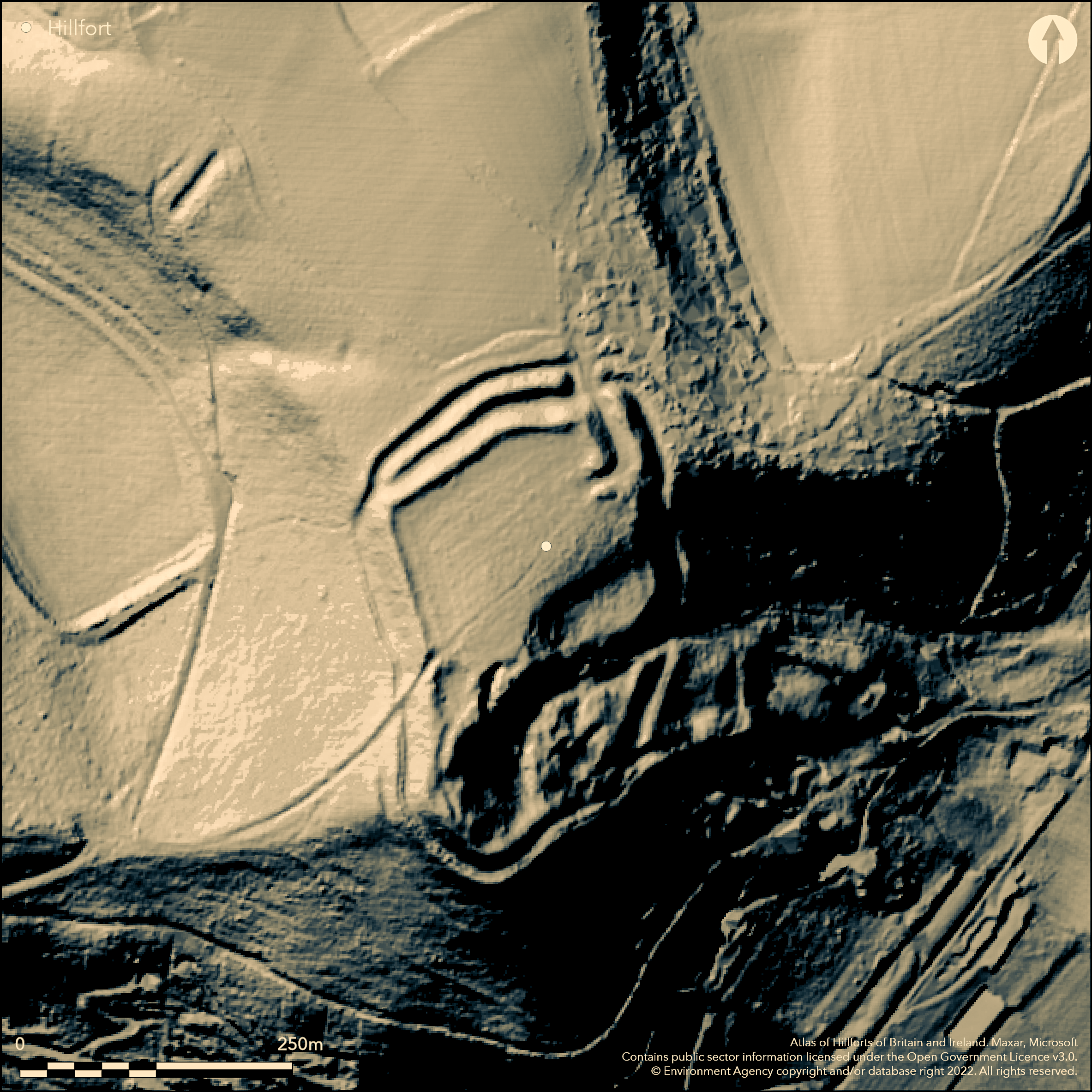
Multivallate, contour hillfort with three banks and ditches, situated on prominent hill summit above important confluences of Rivers Wye and Lugg and Frome and Lugg. Steep surrounding slopes, precipitous on S. Internal area c. 2.8ha. Ramparts continuous on N side, but, although damaged, inner and outer ramparts continuous on W side. Damaged and discontinuous on E and S, probably result of an ancient landslip. Two possibly original entrances in evidence. 'Adam's Rocks' lie in S interior. Spurious association with St. Ethelbert, and not referred to as 'Backbury' until 1926. Although the circuit continuous in part, the site is generally damaged and tree covered. An access track runs NE to SW passing through the NW entrance. On 1st Ed. OS map (1888). Undated.
Citizen Science: ✗
Reliability of Data: Confirmed
Reliability of Interpretation: Confirmed
X: -289837 Y: 6808611 (EPSG: 3857)
Longitude: -2.6036508282115807 Latitude: 52.046907055121885 (EPSG:4326)
Country: England
Current County or Unitary Authority: Herefordshire
Historic County: Herefordshire
Current Parish/Community/Council/Townland: Dormington
Although the circuit continuous in part, the site is generally damaged and tree covered. An ancient landslip seems to have taken the defences on the E and S. An access track runs NE to SW passing through the NW entrance.
| Extant | ✓ |
| Cropmark | ✗ |
| Likely Destroyed | ✗ |
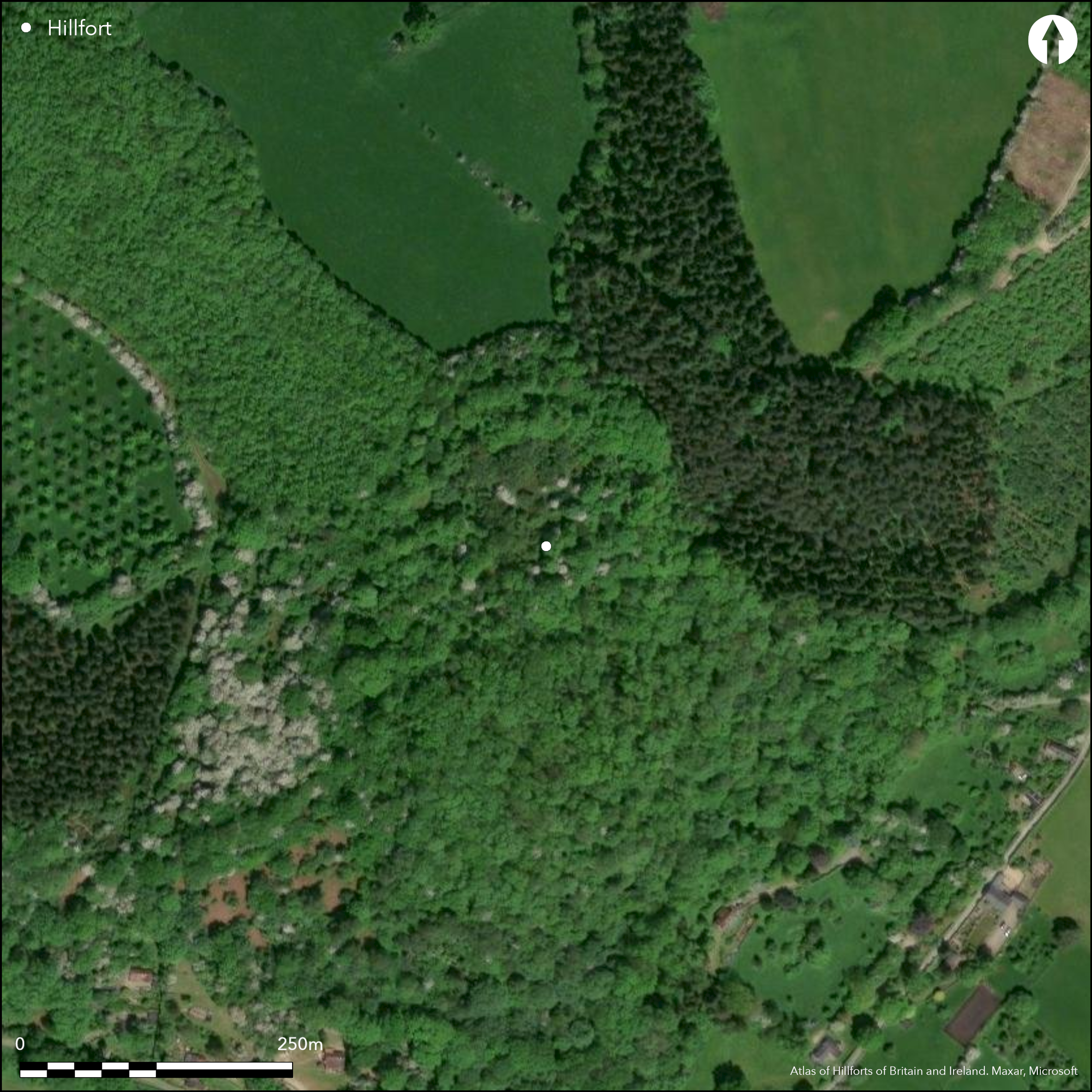
A wooded private site with access problems.
| Woodland | ✓ |
| Commercial Forestry Plantation | ✗ |
| Parkland | ✗ |
| Pasture (Grazing) | ✗ |
| Arable | ✗ |
| Scrub/Bracken | ✗ |
| Bare Outcrop | ✗ |
| Heather/Moorland | ✗ |
| Heath | ✗ |
| Built-up | ✗ |
| Coastal Grassland | ✗ |
| Other | ✗ |
Located part on slopes, part level ground. Sited on top slopes of a prominent hill above important confluences of the Rivers Wye and Lugg and Frome and Lugg
| Contour Fort | ✗ |
| Partial Contour Fort | ✓ |
| Promontory Fort | ✗ |
| Hillslope Fort | ✗ |
| Level Terrain Fort | ✗ |
| Marsh Fort | ✗ |
| Multiple Enclosure Fort | ✗ |
| Hilltop | ✓ |
| Coastal Promontory | ✗ |
| Inland Promontory | ✗ |
| Valley Bottom | ✗ |
| Knoll/Hillock/Outcrop | ✗ |
| Ridge | ✗ |
| Cliff/Plateau-edge/Scarp | ✗ |
| Hillslope | ✓ |
| Lowland | ✗ |
| Spur | ✗ |
Dominant Topographic Feature: Hilltop including the Adam's Rocks outcrop
| North | ✗ |
| Northeast | ✗ |
| East | ✗ |
| Southeast | ✓ |
| South | ✓ |
| Southwest | ✗ |
| West | ✗ |
| Northwest | ✗ |
| Level | ✓ |
Altitude: 225.0m
N/A
The chance finding of a number of cloudy blue flints, two burnt flints and a core from the W rampart does not indicate dating.
Reliability: D - None
| Pre 1200BC | ✗ |
| 1200BC - 800BC | ✗ |
| 800BC - 400BC | ✗ |
| 400BC - AD50 | ✗ |
| AD50 - AD400 | ✗ |
| AD400 - AD 800 | ✗ |
| Post AD800 | ✗ |
| Unknown | ✓ |
| Pre Hillfort: | None |
| Post Hillfort: | None |
On 1st Ed. OS map (1888). Herefordshire Council survey 2012.
| 1st Identified Map Depiction (1888): | OS map |
| Other (2012): | Herefordshire Council survey |
A number of cloudy blue flints, two burnt flints and a core come from the W rampart, otherwise no evidence.
Stream 0.7km located outside the hillfort.
| None | ✓ |
| Spring | ✗ |
| Stream | ✗ |
| Pool | ✗ |
| Flush | ✗ |
| Well | ✗ |
| Other | ✗ |
None
| No Known Features | ✓ |
| Round Stone Structures | ✗ |
| Rectangular Stone Structures | ✗ |
| Curvilinear Platforms | ✗ |
| Other Roundhouse Evidence | ✗ |
| Pits | ✗ |
| Quarry Hollows | ✗ |
| Other | ✗ |
None
| No Known Excavation | ✓ |
| Pits | ✗ |
| Postholes | ✗ |
| Roundhouses | ✗ |
| Rectangular Structures | ✗ |
| Roads/Tracks | ✗ |
| Quarry Hollows | ✗ |
| Other | ✗ |
| Nothing Found | ✗ |
None
| No Known Geophysics | ✓ |
| Pits | ✗ |
| Roundhouses | ✗ |
| Rectangular Structures | ✗ |
| Roads/Tracks | ✗ |
| Quarry Hollows | ✗ |
| Other | ✗ |
| Nothing Found | ✗ |
A number of cloudy blue flints, two burnt flints and a core come from the W rampart.
| No Known Finds | ✗ |
| Pottery | ✗ |
| Metal | ✗ |
| Metalworking | ✗ |
| Human Bones | ✗ |
| Animal Bones | ✗ |
| Lithics | ✓ |
| Environmental | ✗ |
| Other | ✗ |
None
| APs Not Checked | ✓ |
| None | ✗ |
| Roundhouses | ✗ |
| Rectangular Structures | ✗ |
| Pits | ✗ |
| Postholes | ✗ |
| Roads/Tracks | ✗ |
| Other | ✗ |
The curving N entrance is complex with inturn and banks. That to the SW is simple cutting through the ramparts with a natural causeway.
| 2: | Entrances intact |
| 2: | Interesting inturn to N entrance |
Guard Chambers: ✗
Chevaux de Frise: ✗
| 1. In-turned (North): | Complex inturned entrance with curving ramparts and banks. |
| 1. Oblique (North): | Curving ramparts and banks. |
| 2. Simple Gap (South west): | Simple entrance cuttingthrough the ramparts with natural causeway. |
Three ramparts and ditches on the N. Although damaged, inner and outer ramparts continuous on the W side, the outer altered and reduced. Also damaged because of an ancient landslide, the ramparts are discontinuous on the E and S.
| Area 1: | 2.8ha. |
| Total: | 2.8ha. |
Total Footprint Area: Noneha.
None
| ✗ | None |
| ✗ | Ramparts damaged and discontinuous. On the W the inner and outer ramparts are continuous, the latter altered and reduced. |
| NE Quadrant: | 3 |
| SE Quadrant: | 1 |
| SW Quadrant: | 2 |
| NW Quadrant: | 3 |
| Total: | 3 |
| Partial Univallate | ✓ |
| Univallate | ✗ |
| Partial Bivallate | ✓ |
| Bivallate | ✗ |
| Partial Multivallate | ✓ |
| Multivallate | ✗ |
| Unknown | ✗ |
| Partial Univallate | ✗ |
| Univallate | ✗ |
| Partial Bivallate | ✗ |
| Bivallate | ✗ |
| Partial Multivallate | ✗ |
| Multivallate | ✗ |
None
| None | ✗ |
| Earthen Bank | ✓ |
| Stone Wall | ✗ |
| Rubble | ✗ |
| Wall-walk | ✗ |
| Evidence of Timber | ✗ |
| Vitrification | ✗ |
| Other Burning | ✗ |
| Palisade | ✗ |
| Counter Scarp Bank | ✗ |
| Berm | ✗ |
| Unfinished | ✗ |
| Other | ✗ |
None
| None | ✗ |
| Earthen Bank | ✗ |
| Stone Wall | ✗ |
| Murus Duplex | ✗ |
| Timber-framed | ✗ |
| Timber-laced | ✗ |
| Vitrification | ✗ |
| Other Burning | ✗ |
| Palisade | ✗ |
| Counter Scarp Bank | ✗ |
| Berm | ✗ |
| Unfinished | ✗ |
| No Known Excavation | ✓ |
| Other | ✗ |
| ✗ | None |
| ✓ | Ditches in evidence in the N, but absent or discontinuous elsewhere. |
Number of Ditches: 2
| ✗ | None |
Cooke, W.H. 1882. Collections towards the history and antiquities of the county of Herefordshire in continuation of Duncumb's History; Vol 3 Greytree Hundred. Book in Hereford Library. III.
Dorling, P. and Wigley, A. 2012. Assessment of the archaeological and conservation status of major later prehistoric enclosures in Herefordshire and Shropshire, EH PNUM, Version 3.2, Hereford and Shrewsbury: Herefordshire Council/Shropshire Council.
Page, W. ed.1908. The Victoria County History of the County of Herefordshire, 1, 209-10, London: St Catherine Press.
RCHME 1934. An Inventory of the Historical Monuments in Herefordshire, 1, 71-2, London: HMSO.
Stanford, S. C. (ed.) 1976. Guide to Prehistoric and Roman Sites in Herefordshire. Woolhope Naturalists' Field Club Archaeological Research Section, 17-18.
Atlas of Hillforts:
Wikidata:
This work is licensed under CC BY-SA 4.0![]()
![]()
![]() and should be cited as:
and should be cited as:
Lock, Gary and Ralston, Ian. 2024. Atlas of Hillforts of Britain and Ireland. Available at: https://hillforts.arch.ox.ac.uk
Document Version 1.1