LiDAR 1m DTM Hillshade
Satellite Imagery
LiDAR 1m DTM Hillshade
Satellite Imagery
Scroll left/right to view further images.
HER: Herefordshire MHE818 (1639)
NMR: SO 47 SW 2 (108810)
SM: 1011016
NGR: SO 400724
X: 340000 Y: 272400 (OSGB36)
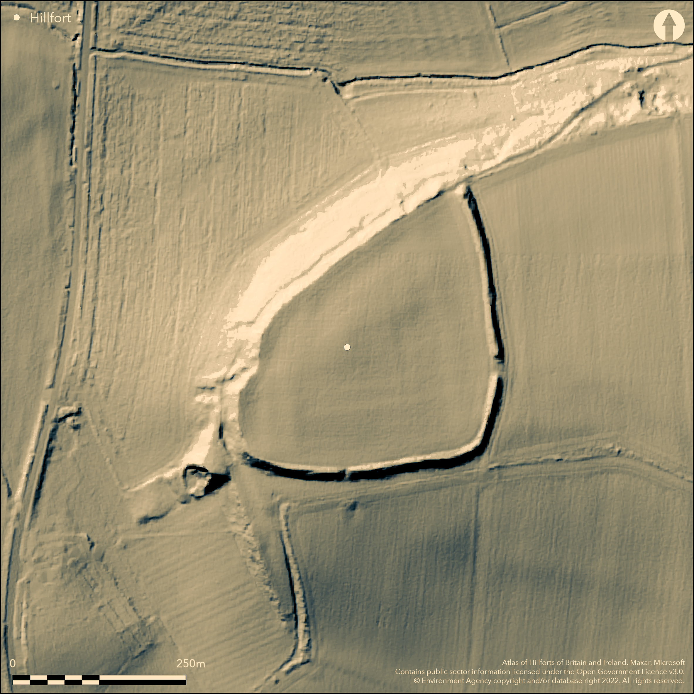
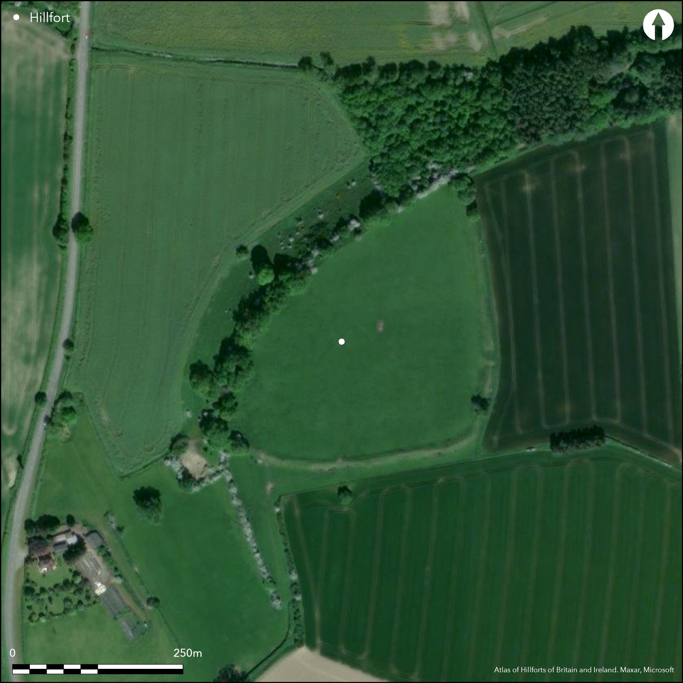
Univallate probable hillslope fort, re-used in the Roman period, located on a slope below the summit of a flat-topped steep hill pointing towards the confluence of the Rivers Teme, Clun and Leintwardine Fishery. Located at a Roman (and possibly earlier) crossing of Branogenium. Opposite to Coxall Knoll hillfort (Atlas No 0010) in an area of prominent hillforts. Iron Age defences comprise two ramparts to the S and E enclosing a triangular area with steep scarp to the NW. Roman defences comprise part of a rampart to the E and bank to the S using the hillfort defences on the N and W. Internal area c. 4.8ha. Possible two entrances. Excavations by S.S. Frere between 1981-85 determined extensive Roman occupation of Neronian date, AD 55-56, with military granary, officer's quarters and commandant's house and trenches of timber buildings cut into the rock. Bronze Age ring-ditch and Iron Age roundhouse found beneath Roman layers. Suggested as possibly part of a larger enclosure to 40ha. The interior is arable and pasture at present. Wooded ramparts. There is a history of ploughing generally. Slumping has occurred around the SE corner. Rabbit problem. However, there has been some general improvement with scrub control measures. On 1st Ed. OS map (1888).
Citizen Science: ✗
Reliability of Data: Confirmed
Reliability of Interpretation: Confirmed
X: -320850 Y: 6862993 (EPSG: 3857)
Longitude: -2.8822421609512636 Latitude: 52.34634387886932 (EPSG:4326)
Country: England
Current County or Unitary Authority: Herefordshire
Historic County: Herefordshire
Current Parish/Community/Council/Townland: Adforton
Slumping has occurred around the SE corner. Rabbit problem. However, there has been some general improvement with scrub control measures.
| Extant | ✓ |
| Cropmark | ✗ |
| Likely Destroyed | ✗ |
The interior is arable and pasture at present. Wooded ramparts. There is a history of ploughing generally.
| Woodland | ✓ |
| Commercial Forestry Plantation | ✗ |
| Parkland | ✗ |
| Pasture (Grazing) | ✓ |
| Arable | ✓ |
| Scrub/Bracken | ✓ |
| Bare Outcrop | ✗ |
| Heather/Moorland | ✗ |
| Heath | ✗ |
| Built-up | ✗ |
| Coastal Grassland | ✗ |
| Other | ✗ |
The site is located on NW slopes just below the summit of a hill and, although it could be called a partial contour site, it is better referred to as a hillslope fort. Sited on a NW slope below the summit of a flat-topped steep hill pointing towards the confluence of the Rivers Teme, Clun and Leintwardine Fishery
| Contour Fort | ✗ |
| Partial Contour Fort | ✗ |
| Promontory Fort | ✗ |
| Hillslope Fort | ✓ |
| Level Terrain Fort | ✗ |
| Marsh Fort | ✗ |
| Multiple Enclosure Fort | ✗ |
| Hilltop | ✓ |
| Coastal Promontory | ✗ |
| Inland Promontory | ✗ |
| Valley Bottom | ✗ |
| Knoll/Hillock/Outcrop | ✗ |
| Ridge | ✗ |
| Cliff/Plateau-edge/Scarp | ✗ |
| Hillslope | ✓ |
| Lowland | ✗ |
| Spur | ✗ |
Dominant Topographic Feature: Flat-topped steep hill.
| North | ✗ |
| Northeast | ✗ |
| East | ✗ |
| Southeast | ✗ |
| South | ✗ |
| Southwest | ✗ |
| West | ✗ |
| Northwest | ✓ |
| Level | ✗ |
Altitude: 150.0m
N/A
Iron Age to Roman and possible later enclosure, based on excavations.
Reliability: B - Medium
| Pre 1200BC | ✗ |
| 1200BC - 800BC | ✗ |
| 800BC - 400BC | ✗ |
| 400BC - AD50 | ✗ |
| AD50 - AD400 | ✓ |
| AD400 - AD 800 | ✓ |
| Post AD800 | ✗ |
| Unknown | ✗ |
| Pre Hillfort: | None |
| Post Hillfort: | None |
| Artefactual: | Iron Age pottery |
| Artefactual: | Samian ware and coins of Neronian date with Spanish amphora. |
In Aubrey's Monumenta Britannica (1665-1693). On 1st Ed. OS map (1888). Excavations by S.S.Frere 1981-85. Aerial Archaeological Survey 2002-2006. Herefordshire Council survey 2012. Brandon Camp Management Plan 2015.
| 1st Identified Map Depiction (1888): | OS map |
| Other (2012): | Herefordshire Council survey. |
| Other (2015): | Management Plan. |
| 1st Identified Written Reference (None): | Aubrey's Monumenta Britannica. |
| Excavation (None): | Excavation by S.S. Frere |
| Other (None): | Herefordshire Aerial Archaeological Survey. |
Possible hut circles 12m-15m in diameter were found in the interior. Excavations proved extensive Roman occupation with possible hut circles in interior. This involved Roman occupation of Neronian date with military granary, officer's quarters and commandant's house and trenches of timber buildings cut into the rock. Large pits also found. Pottery and coins of Neronian date (AD 55-60), including 14 sherds of Samian ware of same date. High status finds in area considered as commandant's quarters. Iron Age iron and bronze buckle. Malvernian Iron Age pottery and Cheshire VCP. Plano-convex flint knife from ring ditch.
Stream 0.1km located outside the hillfort
| None | ✓ |
| Spring | ✗ |
| Stream | ✗ |
| Pool | ✗ |
| Flush | ✗ |
| Well | ✗ |
| Other | ✗ |
Possible hut circles 12m-15m in diameter were found in the interior.
| No Known Features | ✗ |
| Round Stone Structures | ✗ |
| Rectangular Stone Structures | ✗ |
| Curvilinear Platforms | ✗ |
| Other Roundhouse Evidence | ✓ |
| Pits | ✗ |
| Quarry Hollows | ✗ |
| Other | ✗ |
Roman occupation of Neronian date with military granary, officer's quarters and commandant's house and trenches of timber buildings cut into the rock. Large pits also found. Numerous postholes attributed to Iron Age occupation. Evidence of roundhouse near NW rampart. Possible Bronze Age ring ditch at highest point of interior.
| No Known Excavation | ✗ |
| Pits | ✓ |
| Postholes | ✓ |
| Roundhouses | ✓ |
| Rectangular Structures | ✓ |
| Roads/Tracks | ✗ |
| Quarry Hollows | ✗ |
| Other | ✓ |
| Nothing Found | ✗ |
None
| No Known Geophysics | ✓ |
| Pits | ✗ |
| Roundhouses | ✗ |
| Rectangular Structures | ✗ |
| Roads/Tracks | ✗ |
| Quarry Hollows | ✗ |
| Other | ✗ |
| Nothing Found | ✗ |
Pottery and coins of Neronian date (AD 55-60), including 14 sherds of Samian ware of same date. High status finds in area considered as commandant's quarters. Iron Age iron and bronze buckle. Malvernian Iron Age pottery and Cheshire VCP. Plano-convex flint knife from ring ditch.
| No Known Finds | ✗ |
| Pottery | ✓ |
| Metal | ✓ |
| Metalworking | ✗ |
| Human Bones | ✗ |
| Animal Bones | ✗ |
| Lithics | ✓ |
| Environmental | ✗ |
| Other | ✓ |
1959 aerial photograph by J.K. St Josephi interpreted Roman granary and resulted in excavation by Frere 1981-85.
| APs Not Checked | ✗ |
| None | ✗ |
| Roundhouses | ✗ |
| Rectangular Structures | ✓ |
| Pits | ✗ |
| Postholes | ✗ |
| Roads/Tracks | ✗ |
| Other | ✗ |
The gaps to the NE and E have been widened and are possibly original. That to the S is modern.
| 3: | Modern gap to the S. |
| 2: | Off-set entrance on the E. Possibly another to the NW. |
Guard Chambers: ✗
Chevaux de Frise: ✗
| 1. Simple Gap (East): | Gap in rampart widened and possibly original. |
| 2. Simple Gap (North east): | Entrance widened and possibly original. |
Steep natural scarp artificially scarped with berm to 7.5m at the NW. Possible slight inner rampart on the N; remaining sides with simple rampart minus ditch, possibly filled.
| Area 1: | 4.8ha. |
| Total: | 4.8ha. |
Total Footprint Area: Noneha.
None
| ✗ | Area not exact. |
| ✓ | The ramparts are slight but complete the circuit. |
| NE Quadrant: | 1 |
| SE Quadrant: | 1 |
| SW Quadrant: | 1 |
| NW Quadrant: | 1 |
| Total: | 1 |
| Partial Univallate | ✗ |
| Univallate | ✓ |
| Partial Bivallate | ✗ |
| Bivallate | ✗ |
| Partial Multivallate | ✗ |
| Multivallate | ✗ |
| Unknown | ✗ |
| Partial Univallate | ✗ |
| Univallate | ✗ |
| Partial Bivallate | ✗ |
| Bivallate | ✗ |
| Partial Multivallate | ✗ |
| Multivallate | ✗ |
Possible earthen bank with a berm to 7.5m at the NW side.
| None | ✗ |
| Earthen Bank | ✓ |
| Stone Wall | ✗ |
| Rubble | ✗ |
| Wall-walk | ✗ |
| Evidence of Timber | ✗ |
| Vitrification | ✗ |
| Other Burning | ✗ |
| Palisade | ✗ |
| Counter Scarp Bank | ✗ |
| Berm | ✓ |
| Unfinished | ✗ |
| Other | ✗ |
None
| None | ✓ |
| Earthen Bank | ✗ |
| Stone Wall | ✗ |
| Murus Duplex | ✗ |
| Timber-framed | ✗ |
| Timber-laced | ✗ |
| Vitrification | ✗ |
| Other Burning | ✗ |
| Palisade | ✗ |
| Counter Scarp Bank | ✗ |
| Berm | ✗ |
| Unfinished | ✗ |
| No Known Excavation | ✗ |
| Other | ✗ |
| ✗ | None |
| ✗ | Ditches absent and possibly filled. |
Number of Ditches: 0
| ✗ | None |
Dorling, P. and Wigley, A. 2012. Assessment of the archaeological and conservation status of major later prehistoric enclosures in Herefordshire and Shropshire, EH PNUM, Version 3.2, Hereford and Shrewsbury: Herefordshire Council/Shropshire Council.
Frere, S.S. 1987. Brandon Camp, Herefordshire, Britannia,18, 49-92.
RCHME 1934. An Inventory of the Historical Monuments in Herefordshire, 3, NW, 3-4, London: HMSO.
Atlas of Hillforts:
Wikidata:
This work is licensed under CC BY-SA 4.0![]()
![]()
![]() and should be cited as:
and should be cited as:
Lock, Gary and Ralston, Ian. 2024. Atlas of Hillforts of Britain and Ireland. Available at: https://hillforts.arch.ox.ac.uk
Document Version 1.1