LiDAR 1m DTM Hillshade
Satellite Imagery
LiDAR 1m DTM Hillshade
Satellite Imagery
Scroll left/right to view further images.
HER: Herefordshire MHE414 (911)
NMR: SO 53 SE 9 (110314)
SM: 1001759
NGR: SO 593329
X: 359300 Y: 232900 (OSGB36)
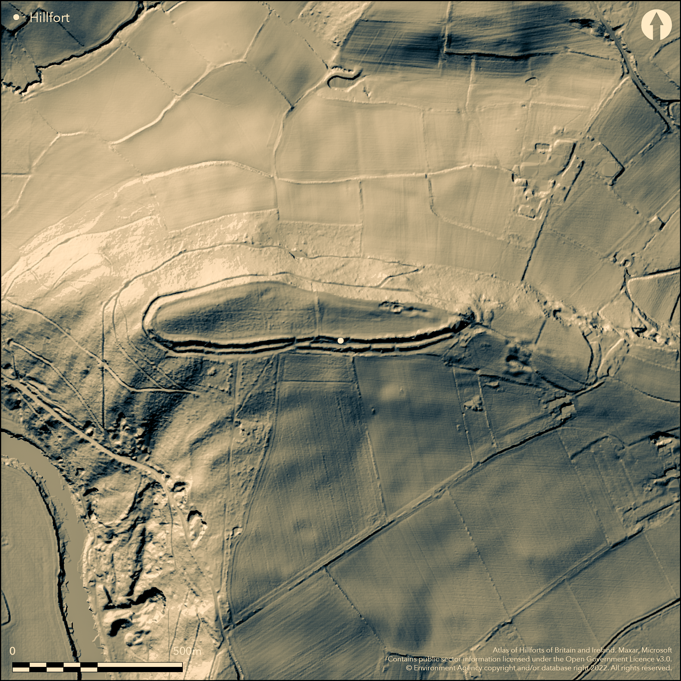
Superbly sited and large, excavated, contour hillfort, strategically located on a steeply sloping spur promontory directly overlooking and dominating a bend in the the River Wye. With strong double and triple ramparts and ditches elsewhere, a sheer drop to the river on the W and N gives maximum protection. Internal area c. 4.6ha. Prominent counterscarp running from the SW corner to NW corner. Entrances to the E (with possible mound or bastion) and midway on S side, which takes a path from Capler Wood, the latter possibly modern. Track runs from the ditch in the NW corner at the base of the scarp edge and possibly masking/utilising a berm. Former 17th/early 18th century cottage in the interior. Long pool in S ditch. E in pasture; W half of site wooded. Site excavated by Jack and Hayter 1925 who opened 15 trenches and found some evidence of metal working and Roman influence. Some tree planting and recreation effects. Pheasant rearing on site with farm landscaping to E. On 1st Ed. OS map (1888). Two
Citizen Science: ✗
Reliability of Data: Confirmed
Reliability of Interpretation: Confirmed
X: -288784 Y: 6798862 (EPSG: 3857)
Longitude: -2.5941871620333394 Latitude: 51.99300935606735 (EPSG:4326)
Country: England
Current County or Unitary Authority: Herefordshire
Historic County: Herefordshire
Current Parish/Community/Council/Townland: Brockhampton (Ross on Wye)
Some tree planting and recreation effects. Pheasant rearing on site with farm landscaping to E.
| Extant | ✓ |
| Cropmark | ✗ |
| Likely Destroyed | ✗ |
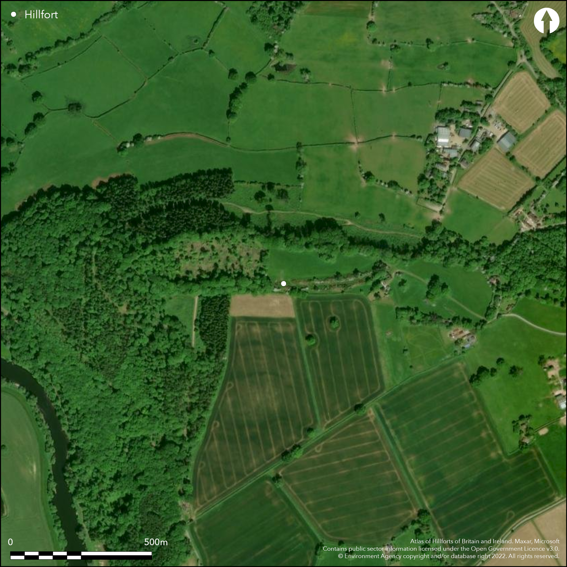
Wooded on the W half of the site with pasture on the E half. Mature trees with general rough grazing and some tree planting. Past remains of post-medieval stone cottage.
| Woodland | ✓ |
| Commercial Forestry Plantation | ✗ |
| Parkland | ✗ |
| Pasture (Grazing) | ✗ |
| Arable | ✗ |
| Scrub/Bracken | ✓ |
| Bare Outcrop | ✗ |
| Heather/Moorland | ✗ |
| Heath | ✗ |
| Built-up | ✓ |
| Coastal Grassland | ✗ |
| Other | ✓ |
The ramparts generally follow the contours at the top of a prominent spur. Sited on a steeply sloping spur directly overlooking and dominating a bend of the the River Wye. Slight slope to the S.
| Contour Fort | ✓ |
| Partial Contour Fort | ✗ |
| Promontory Fort | ✗ |
| Hillslope Fort | ✗ |
| Level Terrain Fort | ✗ |
| Marsh Fort | ✗ |
| Multiple Enclosure Fort | ✗ |
| Hilltop | ✗ |
| Coastal Promontory | ✗ |
| Inland Promontory | ✗ |
| Valley Bottom | ✗ |
| Knoll/Hillock/Outcrop | ✗ |
| Ridge | ✗ |
| Cliff/Plateau-edge/Scarp | ✗ |
| Hillslope | ✗ |
| Lowland | ✗ |
| Spur | ✓ |
Dominant Topographic Feature: Prominent spur
| North | ✗ |
| Northeast | ✗ |
| East | ✗ |
| Southeast | ✗ |
| South | ✓ |
| Southwest | ✗ |
| West | ✗ |
| Northwest | ✗ |
| Level | ✗ |
Altitude: 182.0m
N/A
Possibly Iron Age.
Reliability: C - Low
| Pre 1200BC | ✗ |
| 1200BC - 800BC | ✗ |
| 800BC - 400BC | ✗ |
| 400BC - AD50 | ✗ |
| AD50 - AD400 | ✓ |
| AD400 - AD 800 | ✗ |
| Post AD800 | ✗ |
| Unknown | ✗ |
| Pre Hillfort: | None |
| Post Hillfort: | None |
| Artefactual: | Coin of Lucilla in Hereford Museum and 4th century AD Roman ware fragment suggest Roman influence. |
| Artefactual: | Flint scraper found of possible early date. |
In Aubrey's Monumenta Britannica (1665-1693). On 1st Ed. OS map (1888). Excavation by G.H. Jack and A.G.K. Hayter 1924. Herefordshire Council survey 2012. Visited by Woolhope Club 1990.
| 1st Identified Map Depiction (1888): | OS map |
| Excavation (1924): | Excavation by G.H. Jack and A.G.K. Hayter |
| Other (1990): | Visited by Woolhope Club. |
| Other (2012): | Herefordshire Council survey. |
| 1st Identified Written Reference (None): | Aubrey's Monumenta Britannica (1665-1693) |
Interior surface possibly levelled. Coin of Lucilla in Hereford Museum. 4th century AD Roman ware fragment. Flint scraper of indeterminate date. Lump of iron slag. Boar's tusk fragment, bone fragment (indeterminate) and three snail shells.
Long pond sited in the S ditch between the inner and outer ramparts on site; River Wye located 0.3 km outside hillfort.
| None | ✗ |
| Spring | ✗ |
| Stream | ✓ |
| Pool | ✓ |
| Flush | ✗ |
| Well | ✗ |
| Other | ✗ |
None
| No Known Features | ✓ |
| Round Stone Structures | ✗ |
| Rectangular Stone Structures | ✗ |
| Curvilinear Platforms | ✗ |
| Other Roundhouse Evidence | ✗ |
| Pits | ✗ |
| Quarry Hollows | ✗ |
| Other | ✗ |
Interior surface possibly levelled.
| No Known Excavation | ✗ |
| Pits | ✗ |
| Postholes | ✗ |
| Roundhouses | ✗ |
| Rectangular Structures | ✗ |
| Roads/Tracks | ✗ |
| Quarry Hollows | ✗ |
| Other | ✓ |
| Nothing Found | ✗ |
None
| No Known Geophysics | ✓ |
| Pits | ✗ |
| Roundhouses | ✗ |
| Rectangular Structures | ✗ |
| Roads/Tracks | ✗ |
| Quarry Hollows | ✗ |
| Other | ✗ |
| Nothing Found | ✗ |
Coin of Lucilla in Hereford Museum. 4th century AD Roman ware fragment. Flint scraper of indeterminate date. Lump of iron slag. Boar's tusk fragment, bone fragment (indeterminate) and three snail shells.
| No Known Finds | ✗ |
| Pottery | ✓ |
| Metal | ✗ |
| Metalworking | ✓ |
| Human Bones | ✗ |
| Animal Bones | ✓ |
| Lithics | ✓ |
| Environmental | ✓ |
| Other | ✓ |
None
| APs Not Checked | ✓ |
| None | ✗ |
| Roundhouses | ✗ |
| Rectangular Structures | ✗ |
| Pits | ✗ |
| Postholes | ✗ |
| Roads/Tracks | ✗ |
| Other | ✗ |
There are two entrances, one to the E and another midway on S side, which takes a path from Capler Wood, the latter being possibly modern. E entrance inturned with possible mound or bastion, but not in original condition.
| 2: | Entrance on the S probably modern. |
| 2: | Entrance on the E protected by a mound/possible bastion. |
Guard Chambers: ✗
Chevaux de Frise: ✗
| 1. In-turned (East): | E entrance inturned with possible mound or bastion, but not in original condition. |
| 1. Other Forms (East): | Possible mound or bastian. |
Scarped natural slope on the direct W and N sides, with two ramparts and ditches on the weaker S. To the SW there are three ramparts and second ditch. The S side has substantial ramparts as opposed to the naturally defended N.
| Area 1: | 4.6ha. |
| Total: | 4.6ha. |
Total Footprint Area: Noneha.
None
| ✗ | The site makes full use of the natural contours. |
| ✓ | Scarped natural slope on the direct W and N sides. Strong natural defence on the N and W where there is a sheer drop to river. |
| NE Quadrant: | 1 |
| SE Quadrant: | 2 |
| SW Quadrant: | 3 |
| NW Quadrant: | 2 |
| Total: | 3 |
| Partial Univallate | ✓ |
| Univallate | ✗ |
| Partial Bivallate | ✓ |
| Bivallate | ✗ |
| Partial Multivallate | ✓ |
| Multivallate | ✗ |
| Unknown | ✗ |
| Partial Univallate | ✗ |
| Univallate | ✗ |
| Partial Bivallate | ✗ |
| Bivallate | ✗ |
| Partial Multivallate | ✗ |
| Multivallate | ✗ |
Possible earthen bank. Track runs from the ditch in the NW corner at the base of the scarp edge and possibly masking/utilising a berm. Prominent counterscarp running from the SW corner to NW corner.
| None | ✗ |
| Earthen Bank | ✓ |
| Stone Wall | ✗ |
| Rubble | ✗ |
| Wall-walk | ✗ |
| Evidence of Timber | ✗ |
| Vitrification | ✗ |
| Other Burning | ✗ |
| Palisade | ✗ |
| Counter Scarp Bank | ✓ |
| Berm | ✓ |
| Unfinished | ✗ |
| Other | ✗ |
None
| None | ✓ |
| Earthen Bank | ✗ |
| Stone Wall | ✗ |
| Murus Duplex | ✗ |
| Timber-framed | ✗ |
| Timber-laced | ✗ |
| Vitrification | ✗ |
| Other Burning | ✗ |
| Palisade | ✗ |
| Counter Scarp Bank | ✗ |
| Berm | ✗ |
| Unfinished | ✗ |
| No Known Excavation | ✗ |
| Other | ✗ |
| ✗ | None |
| ✓ | The N and W sides are naturally strong and defended by a ditch only. Ditches with ramparts elsewhere. |
Number of Ditches: 2
| ✗ | None |
Bull, H G. 1883. Woldbury, or Caplar Camp.,Trans Woolhope Natur Field Club, 44-49.
Dorling, P. and Wigley, A. 2012. Assessment of the archaeological and conservation status of major later prehistoric enclosures in Herefordshire and Shropshire, EH PNUM, Version 3.2, Hereford and Shrewsbury: Herefordshire Council/Shropshire Council.
Jack, G.H. and Haytor, A.G.K. 1925. Excavations at the site of Capler Camp. Trans Woolhope Natur Fld Club, 83-88.
Page, W. ed. 1908. The Victoria County History of the County of Herefordshire, 1, 204-5, London: St Catherine Press.
Atlas of Hillforts:
Wikidata:
This work is licensed under CC BY-SA 4.0![]()
![]()
![]() and should be cited as:
and should be cited as:
Lock, Gary and Ralston, Ian. 2024. Atlas of Hillforts of Britain and Ireland. Available at: https://hillforts.arch.ox.ac.uk
Document Version 1.1