LiDAR 1m DTM Hillshade
Satellite Imagery
LiDAR 1m DTM Hillshade
Satellite Imagery
Scroll left/right to view further images.
HER: Herefordshire MHE30 (197); Shropshire MSA868
NMR: SO 37 SE 6 (106821)
SM: 1014107
NGR: SO 366734
X: 336600 Y: 273400 (OSGB36)
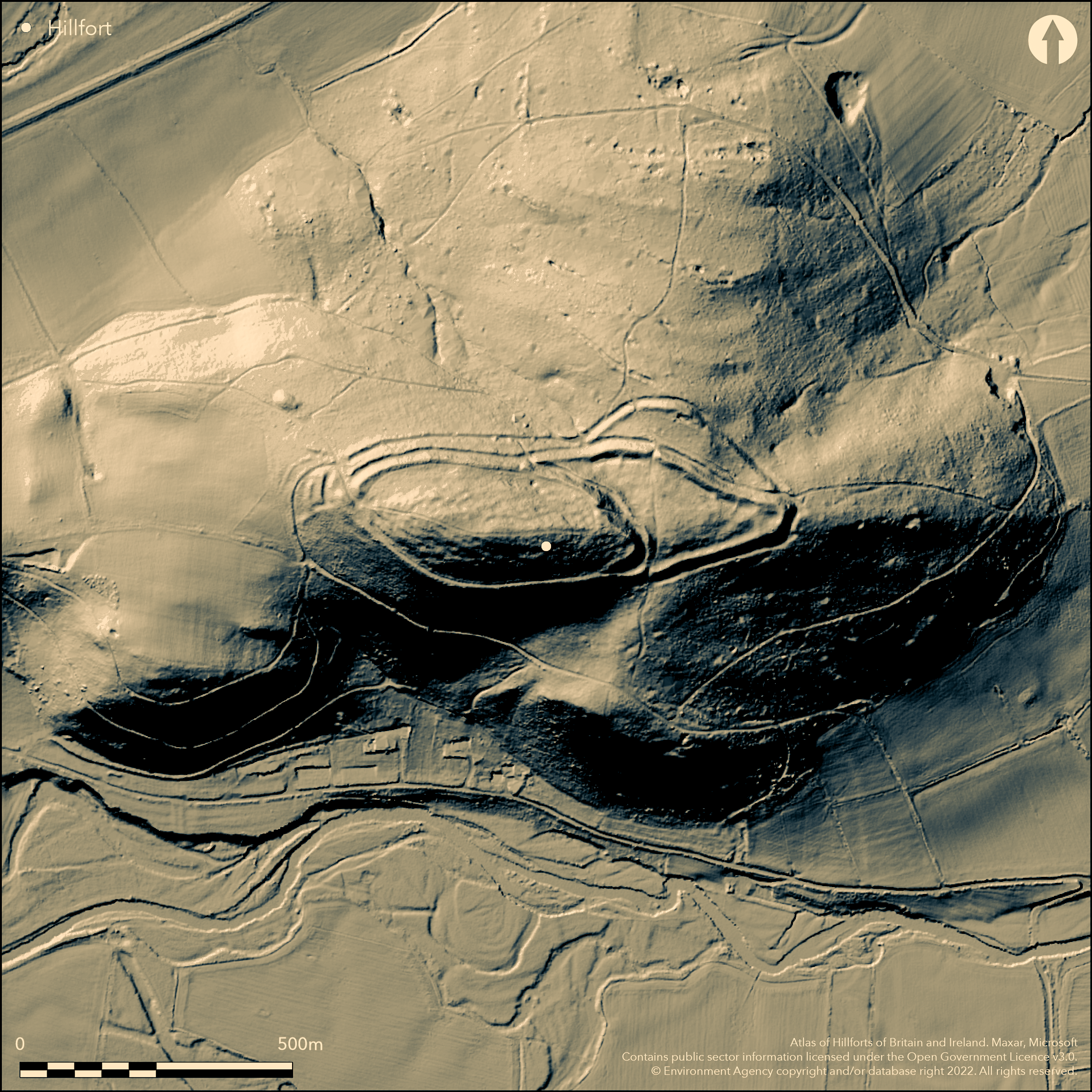
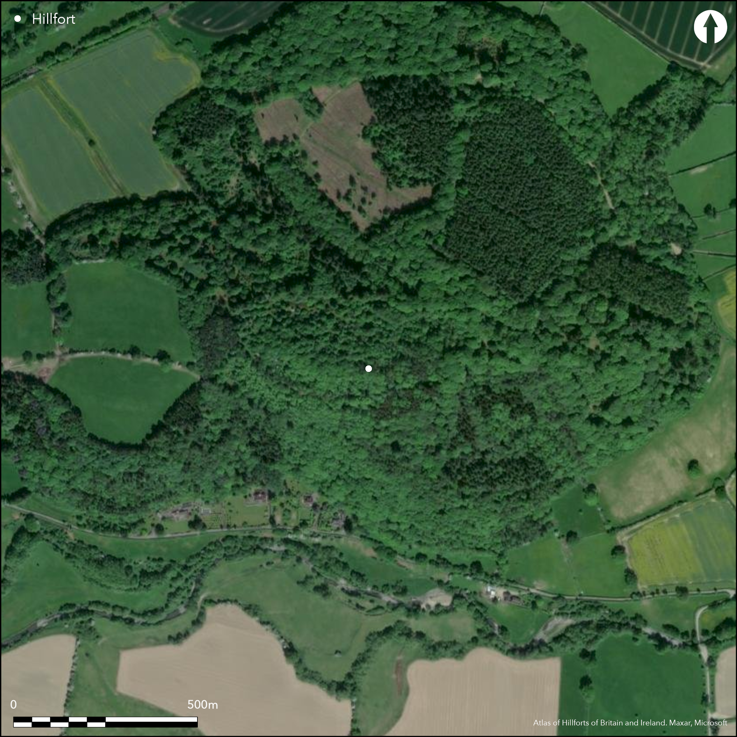
Formerly a fine and large contour hillfort on steep slopes, now tree covered and in three enclosures, above the River Teme and its confluence with the River Clun and Leintwardine Fishery. The three enclosures within a continuous line of defences, some fragmentary, are the result of possible phased construction rather than annexe - Phase I multivallate of 3.2ha; Phase II multivallate of 5.8ha. The W enclosure is defended by three ramparts and two intermediate ditches on the N, and by a berm on the S with a steep natural slope below a steepened scarp above. This is divided from the E enclosure by a double rampart and medial ditch, itself having two ramparts with medial ditch, the outer rampart mostly gone. There is a spoil ditch within the inner rampart. The N and smallest enclosure has a double rampart and medial ditch, the outer fragmented. There are four entrances to the main circuit with internal entrances to the various enclosures. The outwork to the NE outside the defences is not original and considered to be post-medieval linear quarrying. A possible Bronze Age standing stone ("The Frog Stone') is in the NE enclosure. Boundary of Herefordshire and Shropshire passes through site. Only fragments of some of the defences are visible on aerial photographs. Tree covered with conifer plantation and broadleaved woodland. Private site. On 1st Ed. OS map (1888). Undated.
Citizen Science: ✗
Reliability of Data: Confirmed
Reliability of Interpretation: Confirmed
X: -326426 Y: 6864561 (EPSG: 3857)
Longitude: -2.932336667854434 Latitude: 52.354949868229994 (EPSG:4326)
Country: England; England
Current County or Unitary Authority: Herefordshire; Shropshire
Historic County: Herefordshire; Shropshire
Current Parish/Community/Council/Townland: Buckton and Coxall; Bucknell
Private and damaged site precludes further comment.
| Extant | ✓ |
| Cropmark | ✗ |
| Likely Destroyed | ✗ |
Tree covered with conifer plantation and broadleaved woodland.
| Woodland | ✓ |
| Commercial Forestry Plantation | ✓ |
| Parkland | ✗ |
| Pasture (Grazing) | ✗ |
| Arable | ✗ |
| Scrub/Bracken | ✗ |
| Bare Outcrop | ✗ |
| Heather/Moorland | ✗ |
| Heath | ✗ |
| Built-up | ✗ |
| Coastal Grassland | ✗ |
| Other | ✗ |
Complex contour fort on prominent hill. Sited above steep slopes on prominent hill top, now tree covered, above the River Teme and its confluence with the River Clun and Leintwardine Fishery.
| Contour Fort | ✓ |
| Partial Contour Fort | ✗ |
| Promontory Fort | ✗ |
| Hillslope Fort | ✗ |
| Level Terrain Fort | ✗ |
| Marsh Fort | ✗ |
| Multiple Enclosure Fort | ✗ |
| Hilltop | ✓ |
| Coastal Promontory | ✗ |
| Inland Promontory | ✗ |
| Valley Bottom | ✗ |
| Knoll/Hillock/Outcrop | ✗ |
| Ridge | ✗ |
| Cliff/Plateau-edge/Scarp | ✗ |
| Hillslope | ✗ |
| Lowland | ✗ |
| Spur | ✗ |
Dominant Topographic Feature: Prominent Coxall Knoll hill top.
| North | ✗ |
| Northeast | ✗ |
| East | ✗ |
| Southeast | ✗ |
| South | ✗ |
| Southwest | ✗ |
| West | ✗ |
| Northwest | ✗ |
| Level | ✓ |
Altitude: 243.0m
Part of the site is located in Shropshire and part in Herefordshire.
Boundary Type: County
None
Reliability: D - None
| Pre 1200BC | ✗ |
| 1200BC - 800BC | ✗ |
| 800BC - 400BC | ✗ |
| 400BC - AD50 | ✗ |
| AD50 - AD400 | ✗ |
| AD400 - AD 800 | ✗ |
| Post AD800 | ✗ |
| Unknown | ✓ |
| Pre Hillfort: | None |
| Post Hillfort: | None |
In Aubrey's Monumenta Britannica (1665-1693). On 1st Ed. OS map (1888). Herefordshire Council survey 2012.
| 1st Identified Map Depiction (1888): | OS map |
| Other (1967): | Visit by Hillfort Study Group |
| Other (2012): | Herefordshire Council survey |
| 1st Identified Written Reference (None): | In Aubrey's Monumenta Britannica. |
None
River Teme located 0.3 km outside the hillfort.
| None | ✓ |
| Spring | ✗ |
| Stream | ✗ |
| Pool | ✗ |
| Flush | ✗ |
| Well | ✗ |
| Other | ✗ |
None
| No Known Features | ✓ |
| Round Stone Structures | ✗ |
| Rectangular Stone Structures | ✗ |
| Curvilinear Platforms | ✗ |
| Other Roundhouse Evidence | ✗ |
| Pits | ✗ |
| Quarry Hollows | ✗ |
| Other | ✗ |
None
| No Known Excavation | ✓ |
| Pits | ✗ |
| Postholes | ✗ |
| Roundhouses | ✗ |
| Rectangular Structures | ✗ |
| Roads/Tracks | ✗ |
| Quarry Hollows | ✗ |
| Other | ✗ |
| Nothing Found | ✗ |
None
| No Known Geophysics | ✓ |
| Pits | ✗ |
| Roundhouses | ✗ |
| Rectangular Structures | ✗ |
| Roads/Tracks | ✗ |
| Quarry Hollows | ✗ |
| Other | ✗ |
| Nothing Found | ✗ |
None
| No Known Finds | ✓ |
| Pottery | ✗ |
| Metal | ✗ |
| Metalworking | ✗ |
| Human Bones | ✗ |
| Animal Bones | ✗ |
| Lithics | ✗ |
| Environmental | ✗ |
| Other | ✗ |
None
| APs Not Checked | ✗ |
| None | ✓ |
| Roundhouses | ✗ |
| Rectangular Structures | ✗ |
| Pits | ✗ |
| Postholes | ✗ |
| Roads/Tracks | ✗ |
| Other | ✗ |
The principal inturned W entrance is staggered with outworks. Those to the N and S gaps with slight inturns.
| 4: | One of the N entrances (gap) is possibly later. |
| 2: | W, S and one to the N possibly original. |
Guard Chambers: ✗
Chevaux de Frise: ✗
| 1. In-turned (North): | Gap entrance with slight inturns through the ramparts. |
| 2. In-turned (South): | Gap entrance with slight inturns through the ramparts to E enclosure. |
| 3. In-turned (West): | Complex staggered and principal entrance, defended by return of the inner rampart on both sides. |
| 3. Over-lapping (West): | Complex and staggered |
| 3. Outworks (West): | None |
The W enclosure is defended by three ramparts and two intermediate ditches on the N, and by a berm on the S with a steep natural slope below a steepened scarp above. This is divided from the E enclosure by a double rampart and medial ditch, itself having two ramparts with medial ditch, the outer rampart mostly gone. There is a spoil ditch within the inner rampart. The N and smallest enclosure has a double rampart and medial ditch, the outer fragmented. Complex detail to the defences of the three enclosures.
| Area 1: | 3.2ha. |
| Area 2: | 5.8ha. |
| Total: | 5.8ha. |
Total Footprint Area: 9.0ha.
None
| ✓ | The first phase measured 3.2ha; the Phase II to 5.8ha. The three enclosures suggest a multi- period site, but there is no direct evidence for this. Multi period details not determined. |
| ✓ | A complex series of banks define the site. Multi period details not determined. |
| NE Quadrant: | 4 |
| SE Quadrant: | 4 |
| SW Quadrant: | 2 |
| NW Quadrant: | 3 |
| Total: | 4 |
| Partial Univallate | ✗ |
| Univallate | ✗ |
| Partial Bivallate | ✓ |
| Bivallate | ✗ |
| Partial Multivallate | ✓ |
| Multivallate | ✗ |
| Unknown | ✗ |
| Partial Univallate | ✗ |
| Univallate | ✗ |
| Partial Bivallate | ✗ |
| Bivallate | ✗ |
| Partial Multivallate | ✗ |
| Multivallate | ✗ |
Berm on S.
| None | ✗ |
| Earthen Bank | ✓ |
| Stone Wall | ✗ |
| Rubble | ✗ |
| Wall-walk | ✗ |
| Evidence of Timber | ✗ |
| Vitrification | ✗ |
| Other Burning | ✗ |
| Palisade | ✗ |
| Counter Scarp Bank | ✗ |
| Berm | ✓ |
| Unfinished | ✗ |
| Other | ✗ |
None
| None | ✗ |
| Earthen Bank | ✗ |
| Stone Wall | ✗ |
| Murus Duplex | ✗ |
| Timber-framed | ✗ |
| Timber-laced | ✗ |
| Vitrification | ✗ |
| Other Burning | ✗ |
| Palisade | ✗ |
| Counter Scarp Bank | ✗ |
| Berm | ✗ |
| Unfinished | ✗ |
| No Known Excavation | ✓ |
| Other | ✗ |
| ✗ | None |
| ✓ | The ditches are very complex and vary between two and three. |
Number of Ditches: 2
| ✗ | The three enclosures within a continuous line of defences, some fragmentary, are the result of possible phased construction rather than annexe. |
Dorling, P. and Wigley, A. 2012. Assessment of the archaeological and conservation status of major later prehistoric enclosures in Herefordshire and Shropshire, EH PNUM, Version 3.2, Hereford and Shrewsbury: Herefordshire Council/Shropshire Council.
Page, W. ed. 1908. The Victoria County History of the County of Herefordshire, 1, 203, London: St Catherine Press.
RCHME 1931-34. An Inventory of the Historical Monuments in Herefordshire, 3 (NW), 27, London: HMSO.
Atlas of Hillforts:
Wikidata:
This work is licensed under CC BY-SA 4.0![]()
![]()
![]() and should be cited as:
and should be cited as:
Lock, Gary and Ralston, Ian. 2024. Atlas of Hillforts of Britain and Ireland. Available at: https://hillforts.arch.ox.ac.uk
Document Version 1.1