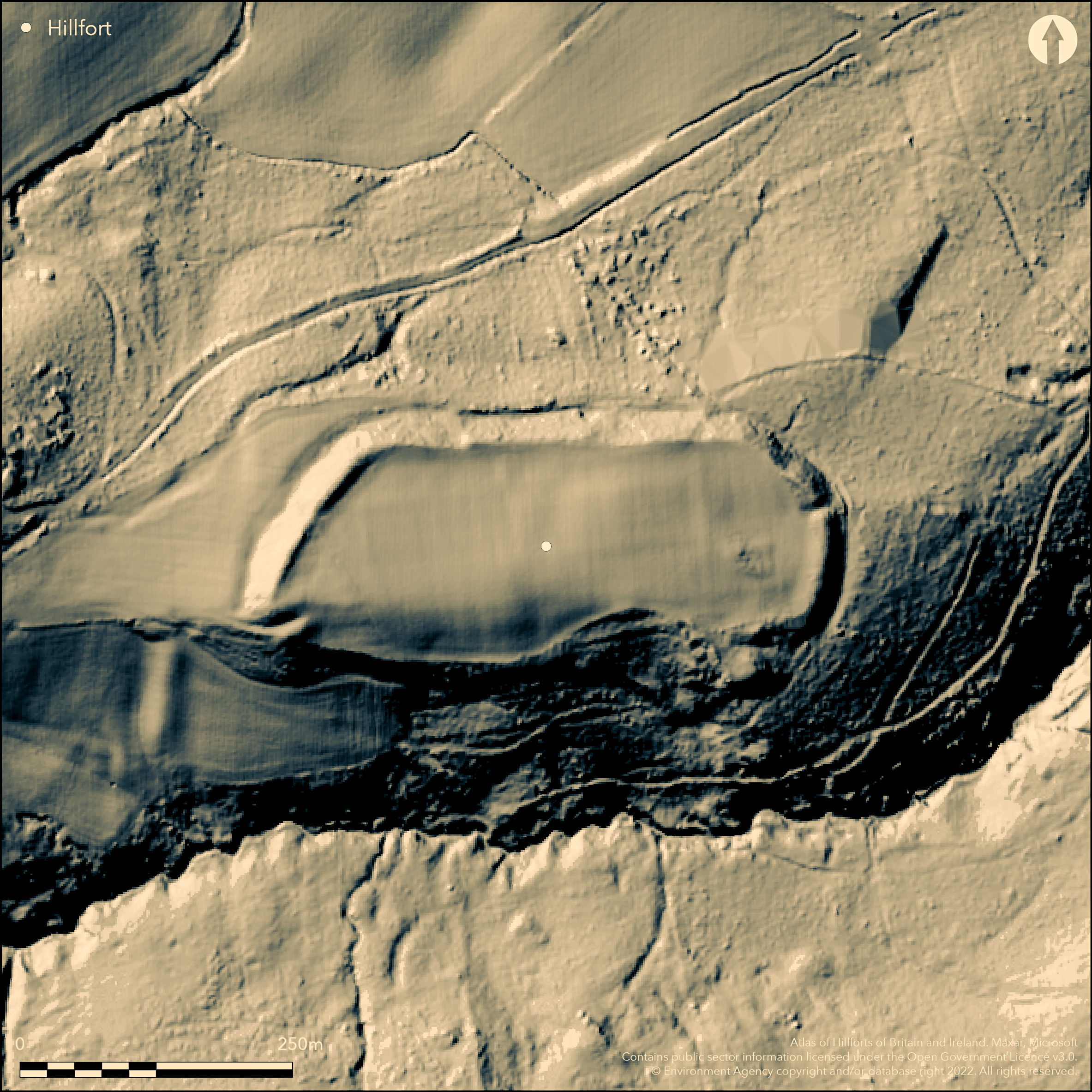
LiDAR 1m DTM Hillshade
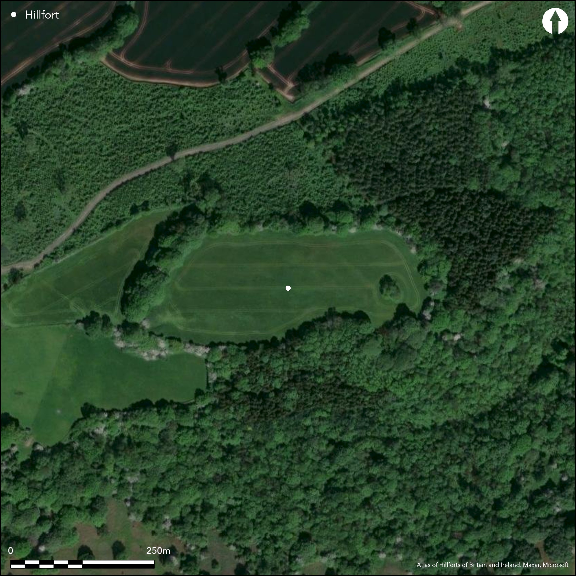
Satellite Imagery
LiDAR 1m DTM Hillshade
Satellite Imagery
Scroll left/right to view further images.
HER: Worcestershire WSM05313 (WSM05313)
NMR: SO 66 SW5 (112664)
SM: 1002942
NGR: SO 620618
X: 362042 Y: 261835 (OSGB36)
Hillslope fort located on steep slopes overlooking the Kyre Brook and the headwaters of the River Frome to the S and W. On 1st Ed OS map (1888). Encloses 3.6ha. Univallate with strong bank and ditch across the W end of a narrow ridge, Naturally steep slopes on the other sides and protected by a bank, which is best preserved to the N and NW. There are four potential entrances, but only two are deemed entirely original. The site is nearly destroyed and is seen as a scarp above natural slopes, best to the W and E ends. The ditch is nearly gone, with vestigial remains on the N side. Roman bricks have been found. Generally grazed pasture.
Citizen Science: ✗
Reliability of Data: Confirmed
Reliability of Interpretation: Confirmed
X: -284699 Y: 6846062 (EPSG: 3857)
Longitude: -2.55749073923361 Latitude: 52.253337408733806 (EPSG:4326)
Country: England
Current County or Unitary Authority: Worcestershire
Historic County: Herefordshire
Current Parish/Community/Council/Townland: Stoke Bliss
The site is almost destroyed with only vestigal remains extant.
| Extant | ✓ |
| Cropmark | ✗ |
| Likely Destroyed | ✓ |
Generally grazed pasture, but near destruction.
| Woodland | ✗ |
| Commercial Forestry Plantation | ✗ |
| Parkland | ✗ |
| Pasture (Grazing) | ✓ |
| Arable | ✗ |
| Scrub/Bracken | ✗ |
| Bare Outcrop | ✗ |
| Heather/Moorland | ✗ |
| Heath | ✗ |
| Built-up | ✗ |
| Coastal Grassland | ✗ |
| Other | ✗ |
A (former) hillslope enclosure. Located on steep slopes overlooking the Kyre Brook and the headwaters of the River Frome to the S and W.
| Contour Fort | ✗ |
| Partial Contour Fort | ✗ |
| Promontory Fort | ✗ |
| Hillslope Fort | ✓ |
| Level Terrain Fort | ✗ |
| Marsh Fort | ✗ |
| Multiple Enclosure Fort | ✗ |
| Hilltop | ✗ |
| Coastal Promontory | ✗ |
| Inland Promontory | ✗ |
| Valley Bottom | ✗ |
| Knoll/Hillock/Outcrop | ✗ |
| Ridge | ✗ |
| Cliff/Plateau-edge/Scarp | ✗ |
| Hillslope | ✓ |
| Lowland | ✗ |
| Spur | ✗ |
Dominant Topographic Feature: Hillslope.
| North | ✗ |
| Northeast | ✗ |
| East | ✓ |
| Southeast | ✗ |
| South | ✗ |
| Southwest | ✗ |
| West | ✗ |
| Northwest | ✗ |
| Level | ✗ |
Altitude: 196.0m
N/A
Roman bricks found.
Reliability: C - Low
| Pre 1200BC | ✗ |
| 1200BC - 800BC | ✗ |
| 800BC - 400BC | ✗ |
| 400BC - AD50 | ✗ |
| AD50 - AD400 | ✗ |
| AD400 - AD 800 | ✗ |
| Post AD800 | ✗ |
| Unknown | ✓ |
| Pre Hillfort: | None |
| Post Hillfort: | Possible Roman use. |
| Artefactual: | Roman bricks found. |
On 1st Ed OS map (1888).
| 1st Identified Map Depiction (1888): | OS map |
None
Stream located 0.1 km outside enclsoure.
| None | ✓ |
| Spring | ✗ |
| Stream | ✗ |
| Pool | ✗ |
| Flush | ✗ |
| Well | ✗ |
| Other | ✗ |
None
| No Known Features | ✓ |
| Round Stone Structures | ✗ |
| Rectangular Stone Structures | ✗ |
| Curvilinear Platforms | ✗ |
| Other Roundhouse Evidence | ✗ |
| Pits | ✗ |
| Quarry Hollows | ✗ |
| Other | ✗ |
None
| No Known Excavation | ✓ |
| Pits | ✗ |
| Postholes | ✗ |
| Roundhouses | ✗ |
| Rectangular Structures | ✗ |
| Roads/Tracks | ✗ |
| Quarry Hollows | ✗ |
| Other | ✗ |
| Nothing Found | ✗ |
None
| No Known Geophysics | ✓ |
| Pits | ✗ |
| Roundhouses | ✗ |
| Rectangular Structures | ✗ |
| Roads/Tracks | ✗ |
| Quarry Hollows | ✗ |
| Other | ✗ |
| Nothing Found | ✗ |
Roman bricks
| No Known Finds | ✗ |
| Pottery | ✗ |
| Metal | ✗ |
| Metalworking | ✗ |
| Human Bones | ✗ |
| Animal Bones | ✗ |
| Lithics | ✗ |
| Environmental | ✗ |
| Other | ✓ |
None
| APs Not Checked | ✓ |
| None | ✗ |
| Roundhouses | ✗ |
| Rectangular Structures | ✗ |
| Pits | ✗ |
| Postholes | ✗ |
| Roads/Tracks | ✗ |
| Other | ✗ |
Although there are four gaps through the ramparts, only W (in-turned) and E (simple gap) can be said to be original.
| 4: | Additional midway gap on E modern; N possibly modern |
| 2: | W and E, possibly original, entrances can be seen |
Guard Chambers: ✗
Chevaux de Frise: ✗
| 1. In-turned (West): | No detail recorded, but probably original. |
| 2. Simple Gap (East): | No detail recorded, but probably original. |
Strong bank and ditch across W end of narrow ridge, naturally steep slopes and bank protection elsewhere.
| Area 1: | 3.6ha. |
| Total: | 3.6ha. |
Total Footprint Area: Noneha.
The southern single rampart is destroyed making interpretation difficult.
| ✗ | The site is nearly destroyed and is thus seen as a scarp above natural slopes, best to the W and E ends. Identification therefore difficult. |
| ✗ | The rampart is nearly destroyed and can only be seen in small sections at the W and E ends of the site. |
| NE Quadrant: | 1 |
| SE Quadrant: | 1 |
| SW Quadrant: | 1 |
| NW Quadrant: | 1 |
| Total: | 1 |
| Partial Univallate | ✗ |
| Univallate | ✓ |
| Partial Bivallate | ✗ |
| Bivallate | ✗ |
| Partial Multivallate | ✗ |
| Multivallate | ✗ |
| Unknown | ✗ |
| Partial Univallate | ✗ |
| Univallate | ✗ |
| Partial Bivallate | ✗ |
| Bivallate | ✗ |
| Partial Multivallate | ✗ |
| Multivallate | ✗ |
None
| None | ✗ |
| Earthen Bank | ✓ |
| Stone Wall | ✗ |
| Rubble | ✗ |
| Wall-walk | ✗ |
| Evidence of Timber | ✗ |
| Vitrification | ✗ |
| Other Burning | ✗ |
| Palisade | ✗ |
| Counter Scarp Bank | ✗ |
| Berm | ✗ |
| Unfinished | ✗ |
| Other | ✗ |
None
| None | ✗ |
| Earthen Bank | ✗ |
| Stone Wall | ✗ |
| Murus Duplex | ✗ |
| Timber-framed | ✗ |
| Timber-laced | ✗ |
| Vitrification | ✗ |
| Other Burning | ✗ |
| Palisade | ✗ |
| Counter Scarp Bank | ✗ |
| Berm | ✗ |
| Unfinished | ✗ |
| No Known Excavation | ✓ |
| Other | ✗ |
| ✗ | None |
| ✓ | The ditch is nearly gone, with vestigial remains on the N side |
Number of Ditches: 1
| ✗ | None |
Bowen, A.R. 1952. The hill-forts of Worcestershire and its borders, Trans Worcs Archaeol Soc, 29, 33-37.
Montgomerie, D.H. 1924. Ancient earthworks, Victoria County History, Worcestershire.
Pevsner, N. 1968. The Buildings of England: Worcestershire, 265.
Phillips, W. 1893. Garmsley Camp (near Tenbury), Trans Woolhope Natur Fld Club, 1893, 142-43.
Atlas of Hillforts:
Wikidata:
This work is licensed under CC BY-SA 4.0![]()
![]()
![]() and should be cited as:
and should be cited as:
Lock, Gary and Ralston, Ian. 2024. Atlas of Hillforts of Britain and Ireland. Available at: https://hillforts.arch.ox.ac.uk
Document Version 1.1