
LiDAR 1m DTM Hillshade
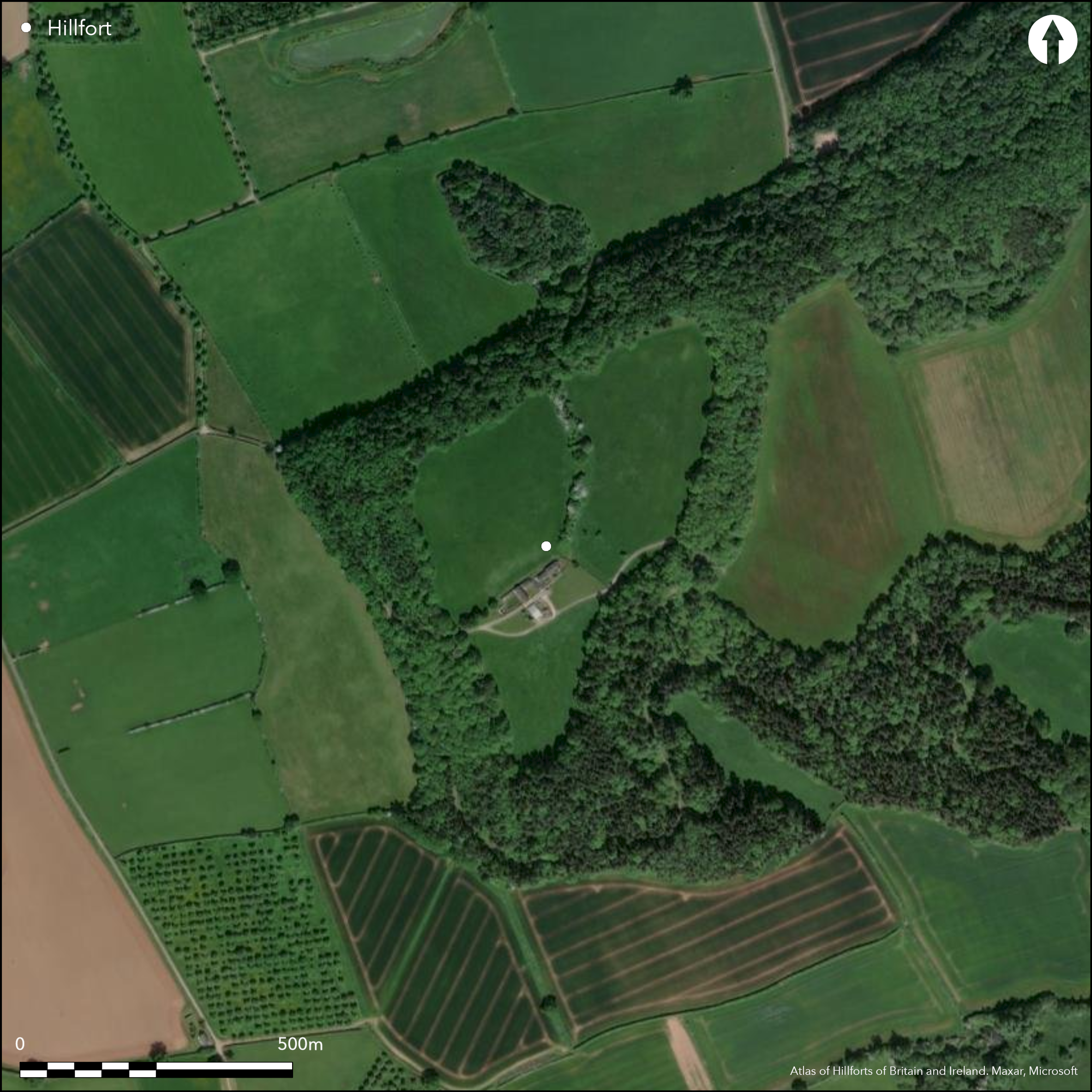
Satellite Imagery
LiDAR 1m DTM Hillshade
Satellite Imagery
Scroll left/right to view further images.
HER: Herefordshire MHE408 (905)
NMR: SO 45 SE 6 (108278)
SM: 1018856
NGR: SO484546
X: 348446 Y: 254689 (OSGB36)
Large, impressive and isolated partial contour hillfort located on a hill overlooking the W bank of the River Arrow and near the confluence of the Rivers Lugg and Arrow. The unusual shape is the result of modern buildings in the interior, wooded ramparts and possible phased construction. There are two enclosures in the interior, that to the NW being earlier and defined on the S and E sides by a crescent-shaped rampart. This has been cut into by the buildings of Camp Farm. Row of 36 postholes found within rampart along the 31m surveyed. The defences closely follow the contours apart from the N part of the E side, and include a massive inner rampart and ditch and traces of a second bank, beyond which on the E side there is a ditch. Interior of the earlier enclosure is 1.5m higher than that to the E. There are five entrances, those on the SE and NE being original. The former is particularly elaborate, the latter inturned. Salvage recording of service trench 1996 found Iron Age pottery and Cheshire and Droitwich VCP. Despite modern buildings of Camp Farm in the interior, wooded ramparts and former quarrying, it is still an impressive site. Permissive path. On 1st Ed OS map (1888).
Citizen Science: ✗
Reliability of Data: Confirmed
Reliability of Interpretation: Confirmed
X: -306747 Y: 6834188 (EPSG: 3857)
Longitude: -2.7555552016460862 Latitude: 52.187988202005414 (EPSG:4326)
Country: England
Current County or Unitary Authority: Herefordshire
Historic County: Herefordshire
Current Parish/Community/Council/Townland: Leominster
Despite modern buildings of Camp Farm in the interior, wooded ramparts and former quarrying, it is still an impressive site. Permissive path.
| Extant | ✓ |
| Cropmark | ✗ |
| Likely Destroyed | ✗ |
Interior devoted to Camp Farm and agriculture. Quarrying.
| Woodland | ✓ |
| Commercial Forestry Plantation | ✗ |
| Parkland | ✗ |
| Pasture (Grazing) | ✓ |
| Arable | ✗ |
| Scrub/Bracken | ✗ |
| Bare Outcrop | ✗ |
| Heather/Moorland | ✗ |
| Heath | ✗ |
| Built-up | ✓ |
| Coastal Grassland | ✗ |
| Other | ✓ |
Ramparts closely follow the contours apart from N half of east side. Located on a hill overlooking the W bank of the River Arrow and near the confluence of the Rivers Lugg and Arrow.
| Contour Fort | ✗ |
| Partial Contour Fort | ✓ |
| Promontory Fort | ✗ |
| Hillslope Fort | ✗ |
| Level Terrain Fort | ✗ |
| Marsh Fort | ✗ |
| Multiple Enclosure Fort | ✗ |
| Hilltop | ✓ |
| Coastal Promontory | ✗ |
| Inland Promontory | ✗ |
| Valley Bottom | ✗ |
| Knoll/Hillock/Outcrop | ✗ |
| Ridge | ✗ |
| Cliff/Plateau-edge/Scarp | ✗ |
| Hillslope | ✗ |
| Lowland | ✗ |
| Spur | ✗ |
Dominant Topographic Feature: Hilltop
| North | ✗ |
| Northeast | ✓ |
| East | ✗ |
| Southeast | ✗ |
| South | ✗ |
| Southwest | ✗ |
| West | ✗ |
| Northwest | ✗ |
| Level | ✓ |
Altitude: 167.0m
N/A
Iron Age pottery (eg Malvernian ware) and briquetage found suggest late Iron Age date of occupation.
Reliability: B - Medium
| Pre 1200BC | ✗ |
| 1200BC - 800BC | ✗ |
| 800BC - 400BC | ✗ |
| 400BC - AD50 | ✓ |
| AD50 - AD400 | ✗ |
| AD400 - AD 800 | ✗ |
| Post AD800 | ✗ |
| Unknown | ✗ |
| Pre Hillfort: | None |
| Post Hillfort: | None |
| Artefactual: | Narrow trench excavation found Iron Age pottery and briquetage. |
In Aubrey's Monumenta Britannica (1665-1693). On 1st Ed OS map (1888). Recording of narrow service trench 1996. Geophysical survey 1996. Watching Brief found no archaeology 2003. Herefordshire Council survey of 2012.
| 1st Identified Map Depiction (1888): | OS map |
| Other (1968): | Visit by Hillfort Study Group |
| Other (1996): | Salvage recording of service trench. |
| Geophysical Survey (1996): | Salvage investigation. |
| Other (2003): | 2003 Watching Brief found no archaeology. |
| Other (2012): | Herefordshire Council survey. |
| 1st Identified Written Reference (None): | Aubrey's Monumenta Britannica. |
Limestone briquetage, Iron Age pottery and limestone rubble associated with occupation found in 1996 service trench. Row of postholes found along section between two enclosures. Human burials found during limestone quarrying. Good bone survival.
Marl Brook located 2.5 km outside hillfort
| None | ✓ |
| Spring | ✗ |
| Stream | ✗ |
| Pool | ✗ |
| Flush | ✗ |
| Well | ✗ |
| Other | ✗ |
None
| No Known Features | ✓ |
| Round Stone Structures | ✗ |
| Rectangular Stone Structures | ✗ |
| Curvilinear Platforms | ✗ |
| Other Roundhouse Evidence | ✗ |
| Pits | ✗ |
| Quarry Hollows | ✗ |
| Other | ✗ |
Recording of narrow service trench 1996 for 400m, SW from the NE corner to Camp Farm. Shallow gullies, postholes and layers of limestone rubble were found associated with occupation.
| No Known Excavation | ✗ |
| Pits | ✗ |
| Postholes | ✓ |
| Roundhouses | ✗ |
| Rectangular Structures | ✗ |
| Roads/Tracks | ✗ |
| Quarry Hollows | ✗ |
| Other | ✓ |
| Nothing Found | ✗ |
Row of postholes found along section between two enclosures found.
| No Known Geophysics | ✗ |
| Pits | ✗ |
| Roundhouses | ✗ |
| Rectangular Structures | ✗ |
| Roads/Tracks | ✗ |
| Quarry Hollows | ✗ |
| Other | ✓ |
| Nothing Found | ✗ |
Late Iron Age pottery and limestone rubble associated with occupation. Cheshire and Droitwich VCP. Single sherd of Severn Valley ware. Human burials found during limestone quarrying. Good bone survival.
| No Known Finds | ✗ |
| Pottery | ✓ |
| Metal | ✗ |
| Metalworking | ✗ |
| Human Bones | ✓ |
| Animal Bones | ✗ |
| Lithics | ✗ |
| Environmental | ✗ |
| Other | ✓ |
None
| APs Not Checked | ✓ |
| None | ✗ |
| Roundhouses | ✗ |
| Rectangular Structures | ✗ |
| Pits | ✗ |
| Postholes | ✗ |
| Roads/Tracks | ✗ |
| Other | ✗ |
The SE entrance is very elaborate and overlapping, that to the NE an interesting inturned passageway.
| 5: | W and E are modern, that E probably not original |
| 2: | SE entrance very elaborate; NE inturned |
Guard Chambers: ✗
Chevaux de Frise: ✗
| 1. Over-lapping (South east): | Very fine and elaborate entrance. |
| 2. In-turned (North east): | Interesting inturned passageway entrance. |
| 2. Passage-way/Corridor (North east): | None |
The defences closely follow the contours apart from the N part of the E side, and include a massive inner rampart and ditch and traces of a second bank, beyond which on the E side there is a ditch. The ramparts are complex in construction with possible stone faces and palisade, that to the S with a continuation in an arc to the W around Camp Wood.
| Area 1: | 10.8ha. |
| Total: | 10.8ha. |
Total Footprint Area: Noneha.
None
| ✓ | The two enclosures and curious shape of the hillfort make a very interesting and complex hillfort. Possibly phased. |
| ✓ | Impressive circuit with massive inner rampart and ditch. |
| NE Quadrant: | 2 |
| SE Quadrant: | 2 |
| SW Quadrant: | 2 |
| NW Quadrant: | 1 |
| Total: | 2 |
| Partial Univallate | ✓ |
| Univallate | ✗ |
| Partial Bivallate | ✓ |
| Bivallate | ✗ |
| Partial Multivallate | ✗ |
| Multivallate | ✗ |
| Unknown | ✗ |
| Partial Univallate | ✗ |
| Univallate | ✓ |
| Partial Bivallate | ✗ |
| Bivallate | ✗ |
| Partial Multivallate | ✗ |
| Multivallate | ✗ |
Parapets possible on the W and N sides. Dumps over which small limestone rubble deposited recorded.
| None | ✗ |
| Earthen Bank | ✓ |
| Stone Wall | ✓ |
| Rubble | ✗ |
| Wall-walk | ✗ |
| Evidence of Timber | ✗ |
| Vitrification | ✗ |
| Other Burning | ✗ |
| Palisade | ✗ |
| Counter Scarp Bank | ✗ |
| Berm | ✓ |
| Unfinished | ✗ |
| Other | ✓ |
Postholes may indicate a palisade.
| None | ✗ |
| Earthen Bank | ✗ |
| Stone Wall | ✗ |
| Murus Duplex | ✗ |
| Timber-framed | ✗ |
| Timber-laced | ✗ |
| Vitrification | ✗ |
| Other Burning | ✗ |
| Palisade | ✓ |
| Counter Scarp Bank | ✗ |
| Berm | ✗ |
| Unfinished | ✗ |
| No Known Excavation | ✗ |
| Other | ✗ |
| ✗ | None |
| ✓ | Ditches in evidence but complex. Separated by berm. |
Number of Ditches: 2
| ✗ | None |
Dalwood, H., Hurst, D. and Pearson, E. 1997. Salvage Recording at Ivington Camp, Leominster: Archive Report. Worcester. Unpublished archive report 570, County Archaeology Service, Hereford and Worcester County Council.
Dorling, P. and Wigley, A. 2012: Assessment of the archaeological and conservation status of major later prehistoric enclosures in Herefordshire and Shropshire, EH PNUM, Version 3.2, Hereford and Shrewsbury: Herefordshire Council/Shropshire Council.
Mayes, S 2003. Camp Farm, Ivington, Herefordshire. Archaeological monitoring. Contractor Report.
Page, W. ed. 1908. The Victoria County History of the County of Herefordshire, 1, 217, London: St Catherine Press.
RCHME 1931-34. An Inventory of the Historical Monuments in Herefordshire, 3 (NW), 131-32, 52, London: HMSO.
Atlas of Hillforts:
Wikidata:
This work is licensed under CC BY-SA 4.0![]()
![]()
![]() and should be cited as:
and should be cited as:
Lock, Gary and Ralston, Ian. 2024. Atlas of Hillforts of Britain and Ireland. Available at: https://hillforts.arch.ox.ac.uk
Document Version 1.1