
LiDAR 1m DTM Hillshade
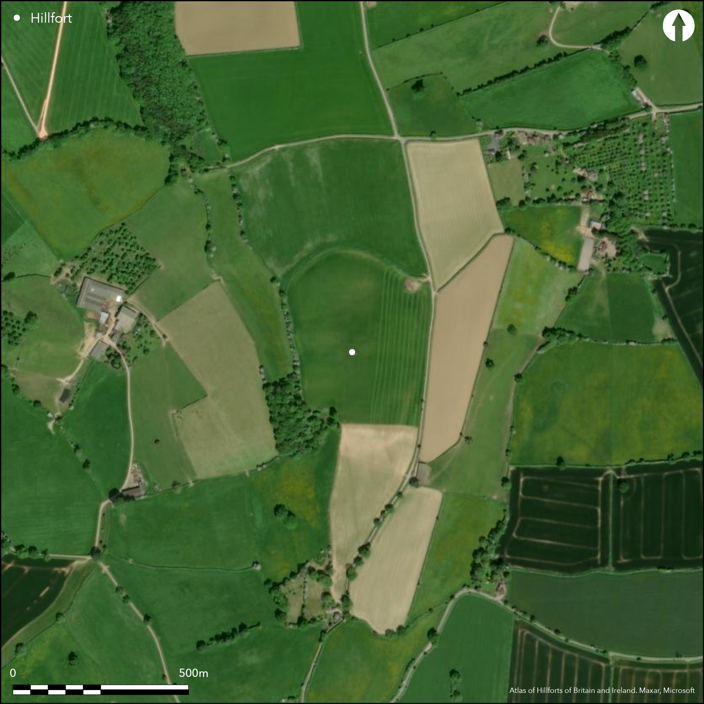
Satellite Imagery
LiDAR 1m DTM Hillshade
Satellite Imagery
Scroll left/right to view further images.
HER: Herefordshire MHE419 (916)
NMR: SO 63 SW 6 (112135)
SM: None
NGR: SO 632325
X: 363206 Y: 232563 (OSGB36)
Large, oval, contour hillfort located on Ridge Hill on the interfluve of the Rivers Severn and Wye, overlooking a sharp bend of the Wye to the W and the valley of Preston Brook to the E, and above Caplar Camp (Atlas No ). Internal area 5.7ha. The ridge has steep slopes on the W, less so on the E. The N rampart rises to 2m-3m above level of field; possibly scarped from ridge. E side is similar. W has steep scarp and berm. The scarping enhances the monumentality of the site. At S end of W ramparts a berm becomes a ditch (faint traces) with external counterscarp bank. The site is in poor condition due to ploughing, but mostly visible. Surface finds suggest late Iron Age to early Romano-British date. On 1st Ed OS map (1888).
Citizen Science: ✗
Reliability of Data: Confirmed
Reliability of Interpretation: Confirmed
X: -282447 Y: 6798363 (EPSG: 3857)
Longitude: -2.5372660060448933 Latitude: 51.99025278025921 (EPSG:4326)
Country: England
Current County or Unitary Authority: Herefordshire
Historic County: Herefordshire
Current Parish/Community/Council/Townland: Much Marcle
In poor condition and badly affected by ploughing over centuries.
| Extant | ✓ |
| Cropmark | ✗ |
| Likely Destroyed | ✗ |
Part wooded, but most under arable.
| Woodland | ✓ |
| Commercial Forestry Plantation | ✗ |
| Parkland | ✗ |
| Pasture (Grazing) | ✗ |
| Arable | ✓ |
| Scrub/Bracken | ✗ |
| Bare Outcrop | ✗ |
| Heather/Moorland | ✗ |
| Heath | ✗ |
| Built-up | ✗ |
| Coastal Grassland | ✗ |
| Other | ✗ |
Site generally follows the contours. Located on the plateau top of Ridge Hill on the interfluve of the Rivers Severn and Wye.
| Contour Fort | ✓ |
| Partial Contour Fort | ✗ |
| Promontory Fort | ✗ |
| Hillslope Fort | ✗ |
| Level Terrain Fort | ✗ |
| Marsh Fort | ✗ |
| Multiple Enclosure Fort | ✗ |
| Hilltop | ✓ |
| Coastal Promontory | ✗ |
| Inland Promontory | ✗ |
| Valley Bottom | ✗ |
| Knoll/Hillock/Outcrop | ✗ |
| Ridge | ✓ |
| Cliff/Plateau-edge/Scarp | ✗ |
| Hillslope | ✗ |
| Lowland | ✗ |
| Spur | ✗ |
Dominant Topographic Feature: Plateau top of ridge.
| North | ✗ |
| Northeast | ✗ |
| East | ✗ |
| Southeast | ✗ |
| South | ✗ |
| Southwest | ✗ |
| West | ✗ |
| Northwest | ✗ |
| Level | ✓ |
Altitude: 180.0m
N/A
Chance finds indicate a late iron Age to Romano-British date for occupation of the fort. Fragments of 'duck stamped' pottery from ploughed-down rampart at NE corner. Coarse black pottery similar to that from Sutton Walls (Atlas No 0031). Small fragment of Romano-British globular jar from W side of fort.
Reliability: C - Low
| Pre 1200BC | ✗ |
| 1200BC - 800BC | ✗ |
| 800BC - 400BC | ✗ |
| 400BC - AD50 | ✓ |
| AD50 - AD400 | ✓ |
| AD400 - AD 800 | ✗ |
| Post AD800 | ✗ |
| Unknown | ✗ |
| Pre Hillfort: | None |
| Post Hillfort: | None |
| Artefactual: | Chance finds of: bronze looped palstave. Bronze Age barbed and tanged grey flint arrowhead. Broken microlith. Worked flint implements. |
| Artefactual: | Fragments of 'duck stamped pottery from ploughed down rampart at NE corner. coarse black pottery similar to that from Sutton Walls. Small fragment of Romano-British globular jar from W side of fort. |
On 1st Ed OS map (1888). Herefordshire Council survey 2012
| 1st Identified Map Depiction (1888): | OS map |
| Other (2012): | Herefordshire Council survey |
No evidence for interior features. Stray finds of 'duck stamped' pottery from ploughed-down rampart at NE corner. coarse black pottery similar to that from Sutton Walls (Atlas No 0031). Small fragment of Romano-British globular jar from W side of fort.
Spring located 0.2 km outside hillfort.
| None | ✓ |
| Spring | ✗ |
| Stream | ✗ |
| Pool | ✗ |
| Flush | ✗ |
| Well | ✗ |
| Other | ✗ |
None
| No Known Features | ✓ |
| Round Stone Structures | ✗ |
| Rectangular Stone Structures | ✗ |
| Curvilinear Platforms | ✗ |
| Other Roundhouse Evidence | ✗ |
| Pits | ✗ |
| Quarry Hollows | ✗ |
| Other | ✗ |
None
| No Known Excavation | ✓ |
| Pits | ✗ |
| Postholes | ✗ |
| Roundhouses | ✗ |
| Rectangular Structures | ✗ |
| Roads/Tracks | ✗ |
| Quarry Hollows | ✗ |
| Other | ✗ |
| Nothing Found | ✗ |
None
| No Known Geophysics | ✓ |
| Pits | ✗ |
| Roundhouses | ✗ |
| Rectangular Structures | ✗ |
| Roads/Tracks | ✗ |
| Quarry Hollows | ✗ |
| Other | ✗ |
| Nothing Found | ✗ |
Fragments of 'duck stamped pottery from ploughed-down rampart at NE corner. Coarse black pottery similar to that from Sutton Walls. Small fragment of Romano-British globular jar from W side of fort.
| No Known Finds | ✗ |
| Pottery | ✓ |
| Metal | ✗ |
| Metalworking | ✗ |
| Human Bones | ✗ |
| Animal Bones | ✗ |
| Lithics | ✗ |
| Environmental | ✗ |
| Other | ✗ |
None
| APs Not Checked | ✓ |
| None | ✗ |
| Roundhouses | ✗ |
| Rectangular Structures | ✗ |
| Pits | ✗ |
| Postholes | ✗ |
| Roads/Tracks | ✗ |
| Other | ✗ |
Shallow valley running up to SW ramparts and strengthening may indicate an entrance, but only slight indication.
| 1: | Possible. |
| 2: | Shallow valley running up to SW ramparts and strengthening may indicate an entrance. |
Guard Chambers: ✗
Chevaux de Frise: ✗
| 1. Other Forms (South west): | Shallow valley running up to SW ramparts and strengthening may indicate an entrance. |
The N rampart rises to 2m-3m above level of field; possibly scarped from ridge. E side is similar. W has steep scarp and berm. At S end of W defences berm becomes a ditch with external counterscarp bank. Although ploughed-down the structure of the site is visible.
| Area 1: | 5.7ha. |
| Total: | 5.7ha. |
Total Footprint Area: Noneha.
None
| ✗ | None |
| ✓ | Ramparts much eroded and ploughed-down except to the N. Large site in poor condition, but area definition possible. |
| NE Quadrant: | 1 |
| SE Quadrant: | 1 |
| SW Quadrant: | 1 |
| NW Quadrant: | 1 |
| Total: | 1 |
| Partial Univallate | ✗ |
| Univallate | ✓ |
| Partial Bivallate | ✗ |
| Bivallate | ✗ |
| Partial Multivallate | ✗ |
| Multivallate | ✗ |
| Unknown | ✗ |
| Partial Univallate | ✗ |
| Univallate | ✗ |
| Partial Bivallate | ✗ |
| Bivallate | ✗ |
| Partial Multivallate | ✗ |
| Multivallate | ✗ |
The detail of the site is visible. At S end of W defences a berm becomes a ditch (faint traces) with external counterscarp bank.
| None | ✗ |
| Earthen Bank | ✓ |
| Stone Wall | ✗ |
| Rubble | ✗ |
| Wall-walk | ✗ |
| Evidence of Timber | ✗ |
| Vitrification | ✗ |
| Other Burning | ✗ |
| Palisade | ✗ |
| Counter Scarp Bank | ✓ |
| Berm | ✓ |
| Unfinished | ✗ |
| Other | ✗ |
None
| None | ✗ |
| Earthen Bank | ✗ |
| Stone Wall | ✗ |
| Murus Duplex | ✗ |
| Timber-framed | ✗ |
| Timber-laced | ✗ |
| Vitrification | ✗ |
| Other Burning | ✗ |
| Palisade | ✗ |
| Counter Scarp Bank | ✗ |
| Berm | ✗ |
| Unfinished | ✗ |
| No Known Excavation | ✓ |
| Other | ✗ |
| ✗ | None |
| ✓ | Faint traces of a ditch to the W. |
Number of Ditches: 1
| ✗ | None |
Dorling, P. and Wigley, A. 2012. Assessment of the archaeological and conservation status of major later prehistoric enclosures in Herefordshire and Shropshire, EH PNUM, Version 3.2, Hereford and Shrewsbury: Herefordshire Council/Shropshire Council.
Page, W. ed.1908. The Victoria County History of the County of Herefordshire, 1, 218, London: St Catherine Press.
RCHME 1931-34. An Inventory of the Historical Monuments in Herefordshire, 2 (E), 134, 41, London: HMSO.
Stanford, S.C. ed. 1976. Guide to Prehistoric and Roman Sites in Herefordshire, Woolhope Naturalists' Field Club Archaeological Research Section, 24.
Atlas of Hillforts:
Wikidata:
This work is licensed under CC BY-SA 4.0![]()
![]()
![]() and should be cited as:
and should be cited as:
Lock, Gary and Ralston, Ian. 2024. Atlas of Hillforts of Britain and Ireland. Available at: https://hillforts.arch.ox.ac.uk
Document Version 1.1