LiDAR 1m DTM Hillshade
Satellite Imagery
LiDAR 1m DTM Hillshade
Satellite Imagery
Scroll left/right to view further images.
HER: Herefordshire MHE41 (208)
NMR: SO 36 SW 14 (106547)
SM: 1011017
NGR: SO 345624
X: 334500 Y: 262400 (OSGB36)
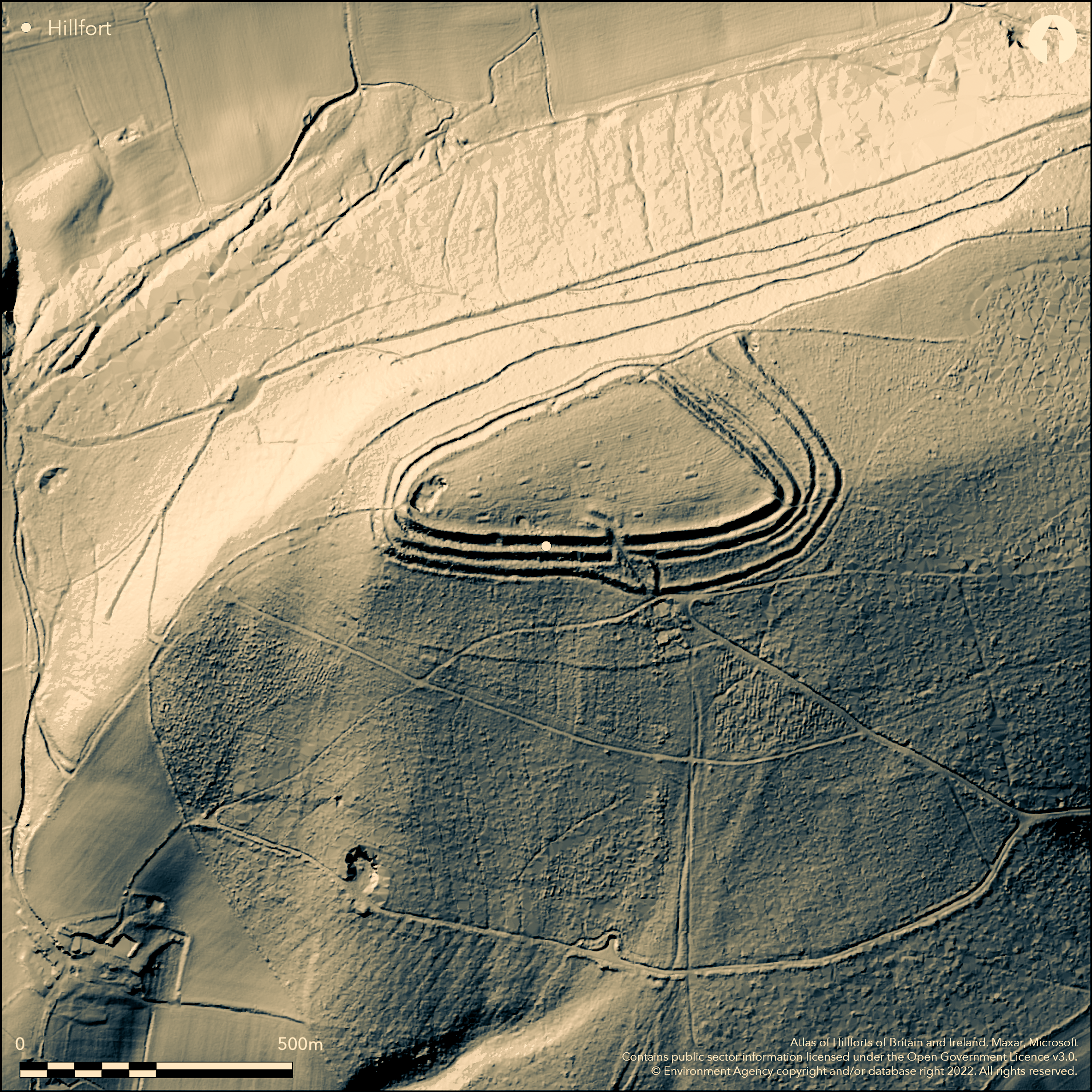
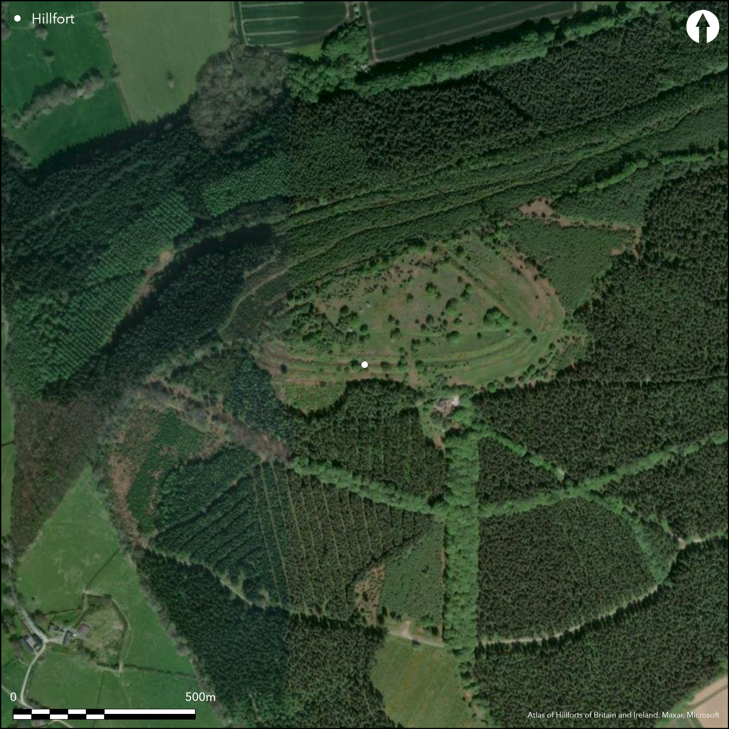
Large, triangular, contour hillfort located on the wooded summit of Wapley Hill overlooking the River Lugg and Hindwell Brook confluence and River Arrow to the S. Triangular asymetric enclosure measuring 420m by 200m, with internal area c. 5.4ha. Defences from the valley below look massive with three banks on the E and W and two scarps on the N. Two banks appear 7m-8m high with berm on outer. Two original entrances to the N and S two others to E and W modern. There are three pillow mounds in the interior and three others outside. Ridge and furrow in interior. Most of site, apart from the outer N rampart, under Forestry Commission ownership. Scrub clearance and bracken and bramble control in Forestry Commission area undertaken through management agreement since 2004, including removal of conifers. Possible harvesting problems in N part of site. Conjecture of reuse by Owain Glyndwr. Undated. On 1st Ed OS map (1886).
Citizen Science: ✗
Reliability of Data: Confirmed
Reliability of Interpretation: Confirmed
X: -329620 Y: 6846514 (EPSG: 3857)
Longitude: -2.9610227881128237 Latitude: 52.25582202987954 (EPSG:4326)
Country: England
Current County or Unitary Authority: Herefordshire
Historic County: Herefordshire
Current Parish/Community/Council/Townland: Staunton on Arrow
Most of site, apart from the outer N rampart,under Forestry Commission ownership. Scrub clearance and bracken and bramble control in Forestry Commission area undertaken through management agreement since 2004, including removal of conifers. Possible harvesting problems in N part of site.
| Extant | ✓ |
| Cropmark | ✗ |
| Likely Destroyed | ✗ |
Part of N rampart under commercial conifer plantation.
| Woodland | ✗ |
| Commercial Forestry Plantation | ✓ |
| Parkland | ✗ |
| Pasture (Grazing) | ✗ |
| Arable | ✗ |
| Scrub/Bracken | ✓ |
| Bare Outcrop | ✗ |
| Heather/Moorland | ✗ |
| Heath | ✗ |
| Built-up | ✗ |
| Coastal Grassland | ✗ |
| Other | ✗ |
Site roughly follows the contours. Large isolated hillfort located on the wooded summit of Wapley Hill.
| Contour Fort | ✓ |
| Partial Contour Fort | ✗ |
| Promontory Fort | ✗ |
| Hillslope Fort | ✗ |
| Level Terrain Fort | ✗ |
| Marsh Fort | ✗ |
| Multiple Enclosure Fort | ✗ |
| Hilltop | ✓ |
| Coastal Promontory | ✗ |
| Inland Promontory | ✗ |
| Valley Bottom | ✗ |
| Knoll/Hillock/Outcrop | ✗ |
| Ridge | ✗ |
| Cliff/Plateau-edge/Scarp | ✗ |
| Hillslope | ✗ |
| Lowland | ✗ |
| Spur | ✗ |
Dominant Topographic Feature: Hill top
| North | ✗ |
| Northeast | ✗ |
| East | ✗ |
| Southeast | ✗ |
| South | ✗ |
| Southwest | ✗ |
| West | ✗ |
| Northwest | ✗ |
| Level | ✓ |
Altitude: 320.0m
N/A
None.
Reliability: D - None
| Pre 1200BC | ✗ |
| 1200BC - 800BC | ✗ |
| 800BC - 400BC | ✗ |
| 400BC - AD50 | ✗ |
| AD50 - AD400 | ✗ |
| AD400 - AD 800 | ✗ |
| Post AD800 | ✗ |
| Unknown | ✓ |
| Pre Hillfort: | None |
| Post Hillfort: | Conjecture of reuse by Owain Glyndwr. Pillow mounds in interior and outside. Ridge and furrow in interior. |
On 1st Ed OS map (1886). Management agreement post 2004. Herefordshire Council survey 2012.
| 1st Identified Map Depiction (1886): | OS map. |
| Other (1968): | Visit by Hillfort Study Group |
| Other (2004): | Management agreement post 2004. |
| Other (2012): | Herefordshire Council survey. |
Three pillow mounds and modern quarry in the interior, otherwise no features recorded.
Hindwell Brook located 0.7 km outside the hillfort.
| None | ✓ |
| Spring | ✗ |
| Stream | ✗ |
| Pool | ✗ |
| Flush | ✗ |
| Well | ✗ |
| Other | ✗ |
Three pillow mounds in the interior. Modern quarry.
| No Known Features | ✗ |
| Round Stone Structures | ✗ |
| Rectangular Stone Structures | ✗ |
| Curvilinear Platforms | ✗ |
| Other Roundhouse Evidence | ✗ |
| Pits | ✗ |
| Quarry Hollows | ✗ |
| Other | ✓ |
None
| No Known Excavation | ✓ |
| Pits | ✗ |
| Postholes | ✗ |
| Roundhouses | ✗ |
| Rectangular Structures | ✗ |
| Roads/Tracks | ✗ |
| Quarry Hollows | ✗ |
| Other | ✗ |
| Nothing Found | ✗ |
None
| No Known Geophysics | ✓ |
| Pits | ✗ |
| Roundhouses | ✗ |
| Rectangular Structures | ✗ |
| Roads/Tracks | ✗ |
| Quarry Hollows | ✗ |
| Other | ✗ |
| Nothing Found | ✗ |
None
| No Known Finds | ✓ |
| Pottery | ✗ |
| Metal | ✗ |
| Metalworking | ✗ |
| Human Bones | ✗ |
| Animal Bones | ✗ |
| Lithics | ✗ |
| Environmental | ✗ |
| Other | ✗ |
None
| APs Not Checked | ✓ |
| None | ✗ |
| Roundhouses | ✗ |
| Rectangular Structures | ✗ |
| Pits | ✗ |
| Postholes | ✗ |
| Roads/Tracks | ✗ |
| Other | ✗ |
To the S an interesting passageway through ramparts with inturns. Possibly the main entrance. To the NE a, possibly original, simple gap through the ramparts. Modern gaps to the E and W.
| 4: | Two modern gaps to the E and W. |
| 2: | Two original entrances to the NE corner and S. |
Guard Chambers: ✗
Chevaux de Frise: ✗
| 1. Simple Gap (North east): | Possibly original gap entrance at NE corner of site. |
| 2. Passage-way/Corridor (South): | Interesting passageway through ramparts with inturns. Possibly the main entrance. |
Defences from the valley below appear massive with three banks on the E and W and two on the N. Two banks 7m-8m high with berm on outer. Two ditches.
| Area 1: | 5.4ha. |
| Total: | 5.4ha. |
Total Footprint Area: Noneha.
None
| ✗ | Triangular asymetric enclosure 420m by 200m. |
| ✓ | The ramparts are variable but complete the circuit. Three banks on the E and W and two on the N. |
| NE Quadrant: | 2 |
| SE Quadrant: | 3 |
| SW Quadrant: | 3 |
| NW Quadrant: | 2 |
| Total: | 3 |
| Partial Univallate | ✗ |
| Univallate | ✗ |
| Partial Bivallate | ✓ |
| Bivallate | ✗ |
| Partial Multivallate | ✓ |
| Multivallate | ✗ |
| Unknown | ✗ |
| Partial Univallate | ✗ |
| Univallate | ✗ |
| Partial Bivallate | ✗ |
| Bivallate | ✗ |
| Partial Multivallate | ✗ |
| Multivallate | ✗ |
Berm on outer.
| None | ✗ |
| Earthen Bank | ✓ |
| Stone Wall | ✗ |
| Rubble | ✗ |
| Wall-walk | ✗ |
| Evidence of Timber | ✗ |
| Vitrification | ✗ |
| Other Burning | ✗ |
| Palisade | ✗ |
| Counter Scarp Bank | ✗ |
| Berm | ✓ |
| Unfinished | ✗ |
| Other | ✗ |
None
| None | ✗ |
| Earthen Bank | ✗ |
| Stone Wall | ✗ |
| Murus Duplex | ✗ |
| Timber-framed | ✗ |
| Timber-laced | ✗ |
| Vitrification | ✗ |
| Other Burning | ✗ |
| Palisade | ✗ |
| Counter Scarp Bank | ✗ |
| Berm | ✗ |
| Unfinished | ✗ |
| No Known Excavation | ✓ |
| Other | ✗ |
| ✗ | None |
| ✓ | Two ditches variable about the site. |
Number of Ditches: 2
| ✗ | None |
Dorling, P. and Wigley, A. 2012. Assessment of the archaeological and conservation status of major later prehistoric enclosures in Herefordshire and Shropshire, EH PNUM, Version 3.2, Hereford and Shrewsbury: Herefordshire Council/Shropshire Council.
Page, W. ed. 1908. The Victoria County History of the County of Herefordshire, 1, 219, London: St Catherine Press.
RCHME 1931-34. An Inventory of the Historical Monuments in Herefordshire, 3, (NW), 185, 12, London: HMSO.
Atlas of Hillforts:
Wikidata:
This work is licensed under CC BY-SA 4.0![]()
![]()
![]() and should be cited as:
and should be cited as:
Lock, Gary and Ralston, Ian. 2024. Atlas of Hillforts of Britain and Ireland. Available at: https://hillforts.arch.ox.ac.uk
Document Version 1.1