LiDAR 1m DTM Hillshade
Satellite Imagery
LiDAR 1m DTM Hillshade
Satellite Imagery
Scroll left/right to view further images.
HER: Shropshire 1245 (None)
NMR: SO 49 SW 19 (109358)
SM: 1009309
NGR: SO 445948
X: 344503 Y: 294794 (OSGB36)
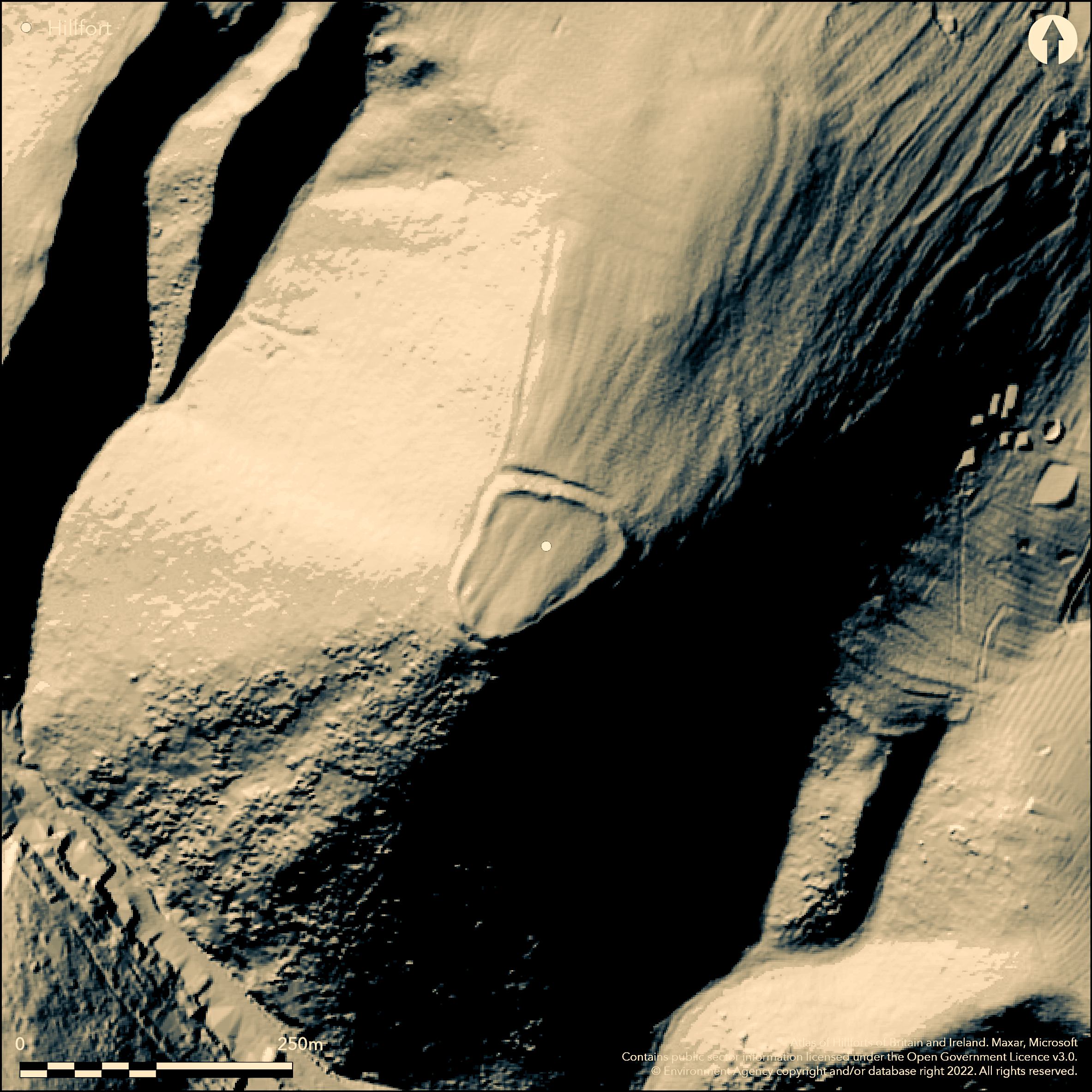
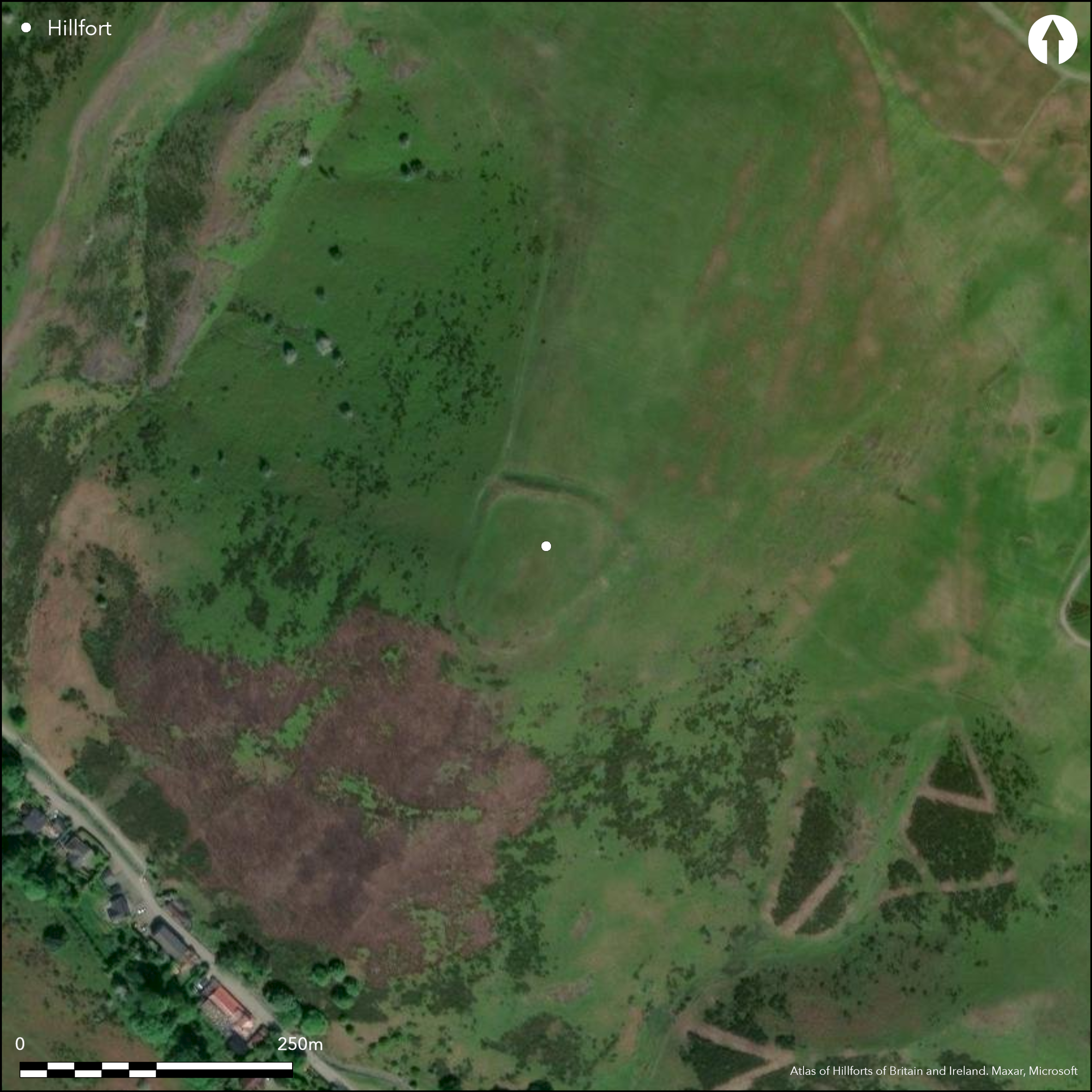
Outstanding, small, inland promontory fort located in a superb position on the summit of Bodbury Hill commanding the Cardingmill Valley and access into the Long Mynd, with precipitous slopes on all side but the N. Measures 0.49ha internal area. Single rampart rising to nearly 2m from the interior, and dropping between c. 5m-6m+ to the deep surrounding ditch, which continues around the headland as a berm of c. 2m width. A simple entrance crosses the N bank at its E end. The bank was possibly originally a cross-dyke cutting off the spur, with the entrance cut later in prehistory and the slopes scarped to form the present enclosure. The scarping with berm emphasises the monumentality of the site. Tumulus to the NE of the site. On 1st Ed OS map (1885-1900).
Citizen Science: ✗
Reliability of Data: Confirmed
Reliability of Interpretation: Confirmed
X: -313907 Y: 6899847 (EPSG: 3857)
Longitude: -2.8198745373615024 Latitude: 52.54812476825069 (EPSG:4326)
Country: England
Current County or Unitary Authority: Shropshire
Historic County: Shropshire
Current Parish/Community/Council/Townland: Church Stretton
Repairs were undertaken 1986-7, 1992 by National Trust and stock reduced over the past decade. To a degree latter resulted in increased bracken encroachment.
| Extant | ✓ |
| Cropmark | ✗ |
| Likely Destroyed | ✗ |
Good pasture, but best seen in winter as badly affected by bracken.
| Woodland | ✗ |
| Commercial Forestry Plantation | ✗ |
| Parkland | ✗ |
| Pasture (Grazing) | ✓ |
| Arable | ✗ |
| Scrub/Bracken | ✓ |
| Bare Outcrop | ✗ |
| Heather/Moorland | ✗ |
| Heath | ✗ |
| Built-up | ✗ |
| Coastal Grassland | ✗ |
| Other | ✗ |
Good example of an inland promontory fort. Located on the promontory summit of Bodbury Hill, with precipitous slopes above the Cardingmill Valley and access into the Long Mynd.
| Contour Fort | ✗ |
| Partial Contour Fort | ✗ |
| Promontory Fort | ✓ |
| Hillslope Fort | ✗ |
| Level Terrain Fort | ✗ |
| Marsh Fort | ✗ |
| Multiple Enclosure Fort | ✗ |
| Hilltop | ✗ |
| Coastal Promontory | ✗ |
| Inland Promontory | ✓ |
| Valley Bottom | ✗ |
| Knoll/Hillock/Outcrop | ✗ |
| Ridge | ✗ |
| Cliff/Plateau-edge/Scarp | ✗ |
| Hillslope | ✗ |
| Lowland | ✗ |
| Spur | ✗ |
Dominant Topographic Feature: Promontory above the Cardingmill Valley.
| North | ✗ |
| Northeast | ✗ |
| East | ✗ |
| Southeast | ✗ |
| South | ✗ |
| Southwest | ✗ |
| West | ✗ |
| Northwest | ✗ |
| Level | ✓ |
Altitude: 373.0m
N/A
The site could have had late Bronze Age origins, the N bank possibly originally a late Bronze Age cross-dyke later incorporated into the hillfort in the Iron Age.
Reliability: D - None
| Pre 1200BC | ✗ |
| 1200BC - 800BC | ✗ |
| 800BC - 400BC | ✗ |
| 400BC - AD50 | ✗ |
| AD50 - AD400 | ✗ |
| AD400 - AD 800 | ✗ |
| Post AD800 | ✗ |
| Unknown | ✓ |
| Pre Hillfort: | None |
| Post Hillfort: | None |
On 1st Ed OS map (1885-1900). Field observation Ordnance Survey 1972. Field observation Shropshire CC 1981. Survey National Trust 1995. Air Photograph Interpretation RCHME: Marches Uplands NMP 1993-2000. Shropshire. Shropshire Council survey 2012.
| Other (1972): | Field observation OS. |
| Other (1981): | Field observation Shropshire CC. |
| Other (1995): | Survey NT. |
| Other (2009): | Visited by Hillfort Study Group |
| Other (2012): | Shropshire Council survey. |
| 1st Identified Map Depiction (None): | OS 1st Ed. |
| Other (None): | Air Photograph Interpretation RCHME: Marches Uplands NMP. |
None
Stream located 0.2 km outside the hillfort.
| None | ✓ |
| Spring | ✗ |
| Stream | ✗ |
| Pool | ✗ |
| Flush | ✗ |
| Well | ✗ |
| Other | ✗ |
None
| No Known Features | ✓ |
| Round Stone Structures | ✗ |
| Rectangular Stone Structures | ✗ |
| Curvilinear Platforms | ✗ |
| Other Roundhouse Evidence | ✗ |
| Pits | ✗ |
| Quarry Hollows | ✗ |
| Other | ✗ |
None
| No Known Excavation | ✓ |
| Pits | ✗ |
| Postholes | ✗ |
| Roundhouses | ✗ |
| Rectangular Structures | ✗ |
| Roads/Tracks | ✗ |
| Quarry Hollows | ✗ |
| Other | ✗ |
| Nothing Found | ✗ |
None
| No Known Geophysics | ✓ |
| Pits | ✗ |
| Roundhouses | ✗ |
| Rectangular Structures | ✗ |
| Roads/Tracks | ✗ |
| Quarry Hollows | ✗ |
| Other | ✗ |
| Nothing Found | ✗ |
None
| No Known Finds | ✓ |
| Pottery | ✗ |
| Metal | ✗ |
| Metalworking | ✗ |
| Human Bones | ✗ |
| Animal Bones | ✗ |
| Lithics | ✗ |
| Environmental | ✗ |
| Other | ✗ |
None
| APs Not Checked | ✓ |
| None | ✗ |
| Roundhouses | ✗ |
| Rectangular Structures | ✗ |
| Pits | ✗ |
| Postholes | ✗ |
| Roads/Tracks | ✗ |
| Other | ✗ |
Simple gap entrance through the N bank, with possible slight inturns. Possible timber bridge over the ditch, as no causeway visible. No modern gaps.
| 1: | No modern gaps. |
| 2: | Simple gap entrance with possible slight inturns. Possible timber bridge over the ditch, as no causeway visible. |
Guard Chambers: ✗
Chevaux de Frise: ✗
| 1. Simple Gap (North): | Simple gap entrance with possible slight inturns. Possible timber bridge over the ditch, as no causeway visible. |
| 1. In-turned (North): | Possible slight inturns. |
| 1. Simple Gap (North): | Possible timber bridge over the ditch, as no causeway visible. |
Single rampart rising to nearly 2m from the interior, and dropping between c. 5m-6m+ to the deep surrounding ditch, which continues around the headland as a berm of c. 2. width. A simple entrance crosses the N bank at its E end. The bank was possibly originally a cross-dyke cutting off the spur, with the entrance cut later in prehistory and the slopes scarped to form the present enclosure.
| Area 1: | 0.49ha. |
| Total: | 0.49ha. |
Total Footprint Area: Noneha.
None
| ✗ | Small fort of definite area. |
| ✗ | The N bank was possibly originally a cross-dyke cutting off the spur. |
| NE Quadrant: | 1 |
| SE Quadrant: | 1 |
| SW Quadrant: | 1 |
| NW Quadrant: | 1 |
| Total: | 1 |
| Partial Univallate | ✗ |
| Univallate | ✓ |
| Partial Bivallate | ✗ |
| Bivallate | ✗ |
| Partial Multivallate | ✗ |
| Multivallate | ✗ |
| Unknown | ✗ |
| Partial Univallate | ✗ |
| Univallate | ✗ |
| Partial Bivallate | ✗ |
| Bivallate | ✗ |
| Partial Multivallate | ✗ |
| Multivallate | ✗ |
Deep surrounding ditch continues around the headland as a berm of c. 2. width.
| None | ✗ |
| Earthen Bank | ✓ |
| Stone Wall | ✗ |
| Rubble | ✗ |
| Wall-walk | ✗ |
| Evidence of Timber | ✗ |
| Vitrification | ✗ |
| Other Burning | ✗ |
| Palisade | ✗ |
| Counter Scarp Bank | ✗ |
| Berm | ✓ |
| Unfinished | ✗ |
| Other | ✗ |
None
| None | ✗ |
| Earthen Bank | ✗ |
| Stone Wall | ✗ |
| Murus Duplex | ✗ |
| Timber-framed | ✗ |
| Timber-laced | ✗ |
| Vitrification | ✗ |
| Other Burning | ✗ |
| Palisade | ✗ |
| Counter Scarp Bank | ✗ |
| Berm | ✗ |
| Unfinished | ✗ |
| No Known Excavation | ✓ |
| Other | ✗ |
| ✗ | None |
| ✓ | The deep surrounding ditch continues around the headland as a berm of c. 2 m width. |
Number of Ditches: 1
| ✗ | None |
Dorling, P. and Wigley, A. 2012. Assessment of the archaeological and conservation status of major later prehistoric enclosures in Herefordshire and Shropshire, EH PNUM, Version 3.2, Hereford and Shrewsbury: Herefordshire Council/Shropshire Council.
Newman, J. and Pevsner, N. 2006. The buildings of England - Shropshire, New Haven and London: Yale University Press.
Page, W. ed. 1908. Victoria County History of Shropshire, 1, 354-55, Institute of Historical Research.
Atlas of Hillforts:
Wikidata:
This work is licensed under CC BY-SA 4.0![]()
![]()
![]() and should be cited as:
and should be cited as:
Lock, Gary and Ralston, Ian. 2024. Atlas of Hillforts of Britain and Ireland. Available at: https://hillforts.arch.ox.ac.uk
Document Version 1.1