LiDAR 1m DTM Hillshade
Satellite Imagery
LiDAR 1m DTM Hillshade
Satellite Imagery
Scroll left/right to view further images.
HER: Shropshire 153 (None)
NMR: SO 38 SE 33 (107215)
SM: 1021071
NGR: SO 382830
X: 338204 Y: 283072 (OSGB36)
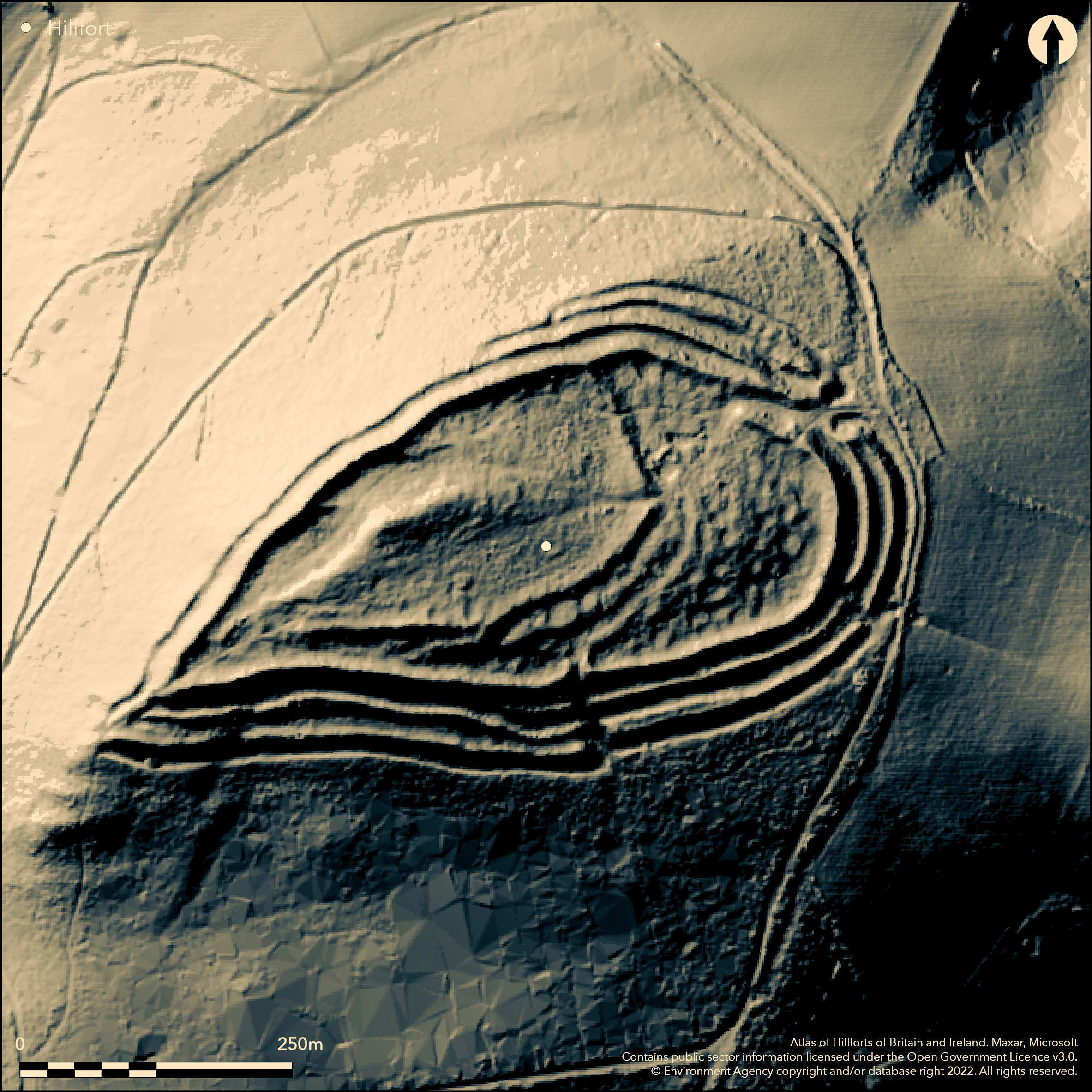
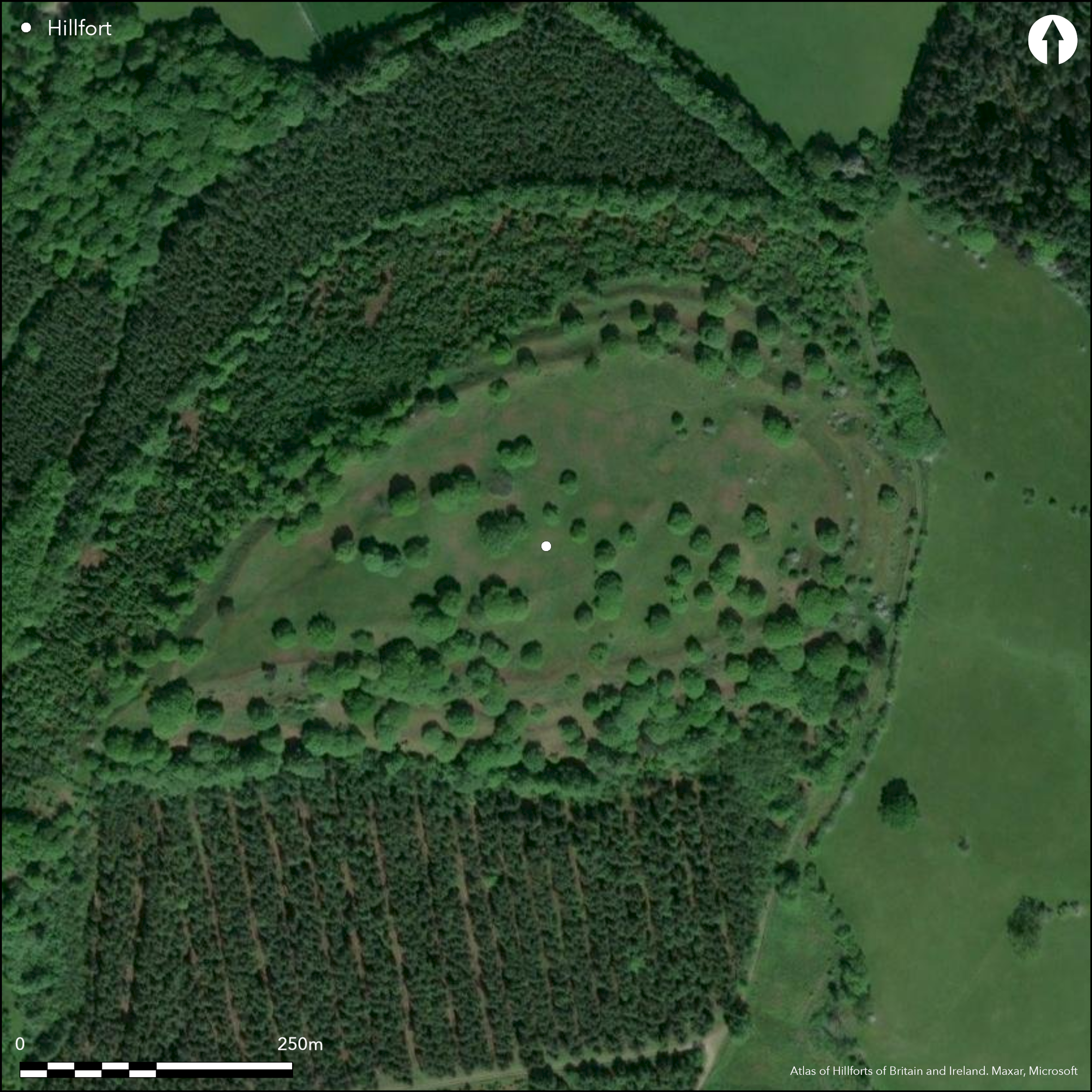
Fine, very steep and prominent, partial contour hillfort located on summit of Burrow Hill near to the confluence of the Rivers Clun and Kemp, in an area of clusters of prominent hillforts. Measures 3.2ha internally. Three massive ramparts in evidence, apart from at the NW where a single rampart and ditch with counterscarp defend the steepest side. Use made of natural outcrops enhance and included in the circuit in the NW sector and on the S side. Three fine probably original entrances. Evidence of c. 20 hut platforms in the SE and NW quadrants. Possible earlier smaller multivallate fort on the highest point as bank runs across hill and site clearly enlarged and strengthened. Small excavation in centre of site by Toller 1978 (unpublished), with evidence of it still remaining on site and trench not filled. Investigation of hut revealed a rock-cut platform and at least two circular hut gullies and postholes. Bracken management and aerial spraying have revealed hut platforms. Finds of 'duck-stamped' pottery of c. 100 BC. Also form, line, contour and resistivity surveys. One of the few sites in the Welsh Marches that has a water supply (spring) on site. Pasture and mature oaks, fine and well preserved, but slopes below tree-covered. On 1st Ed OS map (1885-1900).
Citizen Science: ✗
Reliability of Data: Confirmed
Reliability of Interpretation: Confirmed
X: -324004 Y: 6880457 (EPSG: 3857)
Longitude: -2.91057647130002 Latitude: 52.44207622426947 (EPSG:4326)
Country: England
Current County or Unitary Authority: Shropshire
Historic County: Shropshire
Current Parish/Community/Council/Townland: Hopesay
Bracken management and aerial spraying have revealed hut platforms.
| Extant | ✓ |
| Cropmark | ✗ |
| Likely Destroyed | ✗ |
Pasture and mature oaks, fine and well preserved, but slopes below tree-covered.
| Woodland | ✓ |
| Commercial Forestry Plantation | ✗ |
| Parkland | ✗ |
| Pasture (Grazing) | ✓ |
| Arable | ✗ |
| Scrub/Bracken | ✓ |
| Bare Outcrop | ✗ |
| Heather/Moorland | ✗ |
| Heath | ✗ |
| Built-up | ✗ |
| Coastal Grassland | ✗ |
| Other | ✗ |
Undulating site generally following the contours. Located on the summit of Burrow Hill near to the confluence of the Rivers Clun and Kemp, in an area of clusters of prominent hillforts.
| Contour Fort | ✗ |
| Partial Contour Fort | ✓ |
| Promontory Fort | ✗ |
| Hillslope Fort | ✗ |
| Level Terrain Fort | ✗ |
| Marsh Fort | ✗ |
| Multiple Enclosure Fort | ✗ |
| Hilltop | ✓ |
| Coastal Promontory | ✗ |
| Inland Promontory | ✗ |
| Valley Bottom | ✗ |
| Knoll/Hillock/Outcrop | ✗ |
| Ridge | ✗ |
| Cliff/Plateau-edge/Scarp | ✗ |
| Hillslope | ✗ |
| Lowland | ✗ |
| Spur | ✗ |
Dominant Topographic Feature: Summit of Burrow Hill.
| North | ✗ |
| Northeast | ✗ |
| East | ✗ |
| Southeast | ✗ |
| South | ✗ |
| Southwest | ✗ |
| West | ✗ |
| Northwest | ✗ |
| Level | ✓ |
Altitude: 340.0m
N/A
Excavation found 'duck-stamped' pottery of c. 100 BC. A mortarium rim was found outside the rampart could also indicate Romano-British or Roman interest.
Reliability: B - Medium
| Pre 1200BC | ✗ |
| 1200BC - 800BC | ✗ |
| 800BC - 400BC | ✗ |
| 400BC - AD50 | ✓ |
| AD50 - AD400 | ✓ |
| AD400 - AD 800 | ✗ |
| Post AD800 | ✗ |
| Unknown | ✗ |
| Pre Hillfort: | None |
| Post Hillfort: | None |
| Artefactual: | Excavation found 'duck-stamped' pottery of c. 100 BC. A mortarium rim was found outside the ramparts. |
On 1st Ed OS map (1885-1900). Field observation Ordnance Survey 1973. Small excavation by Toller 1978 (unpublished). Also form, line, contour and resistivity surveys. Field observation Shropshire CC 1981. Field observation English Heritage 1987. Air Photograph Interpretation RCHME: Marches Uplands NMP 1993-2000. Surveys by Shropshire CC 2012.
| Other (1973): | Field observation OS. |
| Excavation (1978): | Small excavation in the interior by Toller, Institute of Archaeology. |
| Other (1981): | Field observation Shropshire CC. |
| Other (1987): | Field observation EH. |
| Other (2009): | Visited by Hillfort Study Group |
| Other (2012): | Shropshire CC survey. |
| 1st Identified Map Depiction (None): | 1st Ed OS |
| Other (None): | Air Photograph Interpretation RCHME: Marches Uplands NMP 1993-2000. |
| Other (None): | Form, line, contour and resistivity surveys. |
Aerial spraying has revealed hut platforms. Evidence of c. 20 hut platforms in the SE and NW quadrants. Investigation of hut revealed a rock-cut platform and at least two circular hut gullies and postholes.
Springs found on site near the NE entrance and at a gap in the third rampart at the SE corner.
| None | ✗ |
| Spring | ✓ |
| Stream | ✗ |
| Pool | ✗ |
| Flush | ✗ |
| Well | ✗ |
| Other | ✗ |
Aerial spraying has revealed hut platforms. Evidence of c. 20 hut platforms in the SE and NW quadrants.
| No Known Features | ✗ |
| Round Stone Structures | ✗ |
| Rectangular Stone Structures | ✗ |
| Curvilinear Platforms | ✓ |
| Other Roundhouse Evidence | ✗ |
| Pits | ✗ |
| Quarry Hollows | ✗ |
| Other | ✗ |
Investigation of hut revealed a rock-cut platform and at least two circular hut gullies and postholes.
| No Known Excavation | ✗ |
| Pits | ✗ |
| Postholes | ✓ |
| Roundhouses | ✓ |
| Rectangular Structures | ✗ |
| Roads/Tracks | ✗ |
| Quarry Hollows | ✗ |
| Other | ✓ |
| Nothing Found | ✗ |
Resistivity surveys of the inner circuit. No details recorded.
| No Known Geophysics | ✗ |
| Pits | ✗ |
| Roundhouses | ✗ |
| Rectangular Structures | ✗ |
| Roads/Tracks | ✗ |
| Quarry Hollows | ✗ |
| Other | ✓ |
| Nothing Found | ✗ |
Sherds of Clee Hill pottery and Malvernian 'duck-stamped' pottery of c. 100 BC. Cheshire VCP. A mortarium rim was found outside the ramparts and an iron or bronze spearhead was found 1893-96; now lost.
| No Known Finds | ✗ |
| Pottery | ✓ |
| Metal | ✓ |
| Metalworking | ✗ |
| Human Bones | ✗ |
| Animal Bones | ✗ |
| Lithics | ✗ |
| Environmental | ✗ |
| Other | ✗ |
None
| APs Not Checked | ✓ |
| None | ✗ |
| Roundhouses | ✗ |
| Rectangular Structures | ✗ |
| Pits | ✗ |
| Postholes | ✗ |
| Roads/Tracks | ✗ |
| Other | ✗ |
Three fine probably original entrances. The principal to the NE is very elaborate with 70 m long passageway and inturned and offset at an oblique angle preventing interior access. That to the S has a causewayed approach to a 30 m long inturn. That to SW (less certain with signs of blocking) has a long narrow passage. The possible earlier hillfort, located where a bank cuts off the hill to the E and S, has a simple entrance on the E..
| 3: | No modern gaps visiible. |
| 2: | Three fine probably original entrances. The principal to the NE is very elaborate with 70 m long passageway and inturned and offset at an oblique angle preventing interior access. That to the S has a causewayed approach to a 30 m long inturn. That to SW (less certain with signs of blocking) has a long narrow passage. The possible earlier hillfort, located where a bank cuts off the hill to the E and S, has a simple entrance on the E. |
Guard Chambers: ✗
Chevaux de Frise: ✗
| 1. Passage-way/Corridor (North east): | The principal entrance to the NE is very elaborate with 70 m long passageway and inturned and offset at an oblique angle preventing interior access. |
| 1. In-turned (North east): | None |
| 1. Oblique (North east): | None |
| 2. In-turned (South): | Entrance to the S has a causewayed approach to a 30 m long inturn. |
| 3. Passage-way/Corridor (South west): | That to SW (less certain with signs of blocking) has a long narrow passage. |
| 3. Blocked (South west): | Signs of blocking. |
Three massive ramparts and ditches in evidence, apart from at the NW where a single rampart and ditch with counterscarp defend the steepest side. Use made of natural outcrops enhance and included in the circuit in the NW sector and on the S side.
| Area 1: | 3.2ha. |
| Total: | 3.2ha. |
Total Footprint Area: Noneha.
None
| ✗ | None |
| ✓ | None |
| NE Quadrant: | 3 |
| SE Quadrant: | 3 |
| SW Quadrant: | 3 |
| NW Quadrant: | 2 |
| Total: | 3 |
| Partial Univallate | ✗ |
| Univallate | ✗ |
| Partial Bivallate | ✓ |
| Bivallate | ✗ |
| Partial Multivallate | ✓ |
| Multivallate | ✗ |
| Unknown | ✗ |
| Partial Univallate | ✗ |
| Univallate | ✗ |
| Partial Bivallate | ✗ |
| Bivallate | ✗ |
| Partial Multivallate | ✗ |
| Multivallate | ✗ |
Counterscarp bank in evidence.
| None | ✗ |
| Earthen Bank | ✓ |
| Stone Wall | ✗ |
| Rubble | ✗ |
| Wall-walk | ✗ |
| Evidence of Timber | ✗ |
| Vitrification | ✗ |
| Other Burning | ✗ |
| Palisade | ✗ |
| Counter Scarp Bank | ✓ |
| Berm | ✗ |
| Unfinished | ✗ |
| Other | ✗ |
No details.
| None | ✓ |
| Earthen Bank | ✗ |
| Stone Wall | ✗ |
| Murus Duplex | ✗ |
| Timber-framed | ✗ |
| Timber-laced | ✗ |
| Vitrification | ✗ |
| Other Burning | ✗ |
| Palisade | ✗ |
| Counter Scarp Bank | ✗ |
| Berm | ✗ |
| Unfinished | ✗ |
| No Known Excavation | ✗ |
| Other | ✗ |
| ✗ | None |
| ✓ | Three massive ramparts and ditches in evidence, apart from at the NW where a single rampart and ditch with counterscarp defend the steepest side. |
Number of Ditches: 3
| ✗ | None |
Dorling, P. and Wigley, A. 2012. Assessment of the archaeological and conservation status of major later prehistoric enclosures in Herefordshire and Shropshire, EH PNUM, Version 3.2, Hereford and Shrewsbury: Herefordshire Council/Shropshire Council.
Page, W. ed. 1908. Victoria County History of Shropshire, 1, 363, Institute of Historical Research.
Watson, M. 2002. Shropshire an archaeological guide, 20-1, plan, Shrewsbury: Shropshire Books.
Atlas of Hillforts:
Wikidata:
This work is licensed under CC BY-SA 4.0![]()
![]()
![]() and should be cited as:
and should be cited as:
Lock, Gary and Ralston, Ian. 2024. Atlas of Hillforts of Britain and Ireland. Available at: https://hillforts.arch.ox.ac.uk
Document Version 1.1