
LiDAR 1m DTM Hillshade
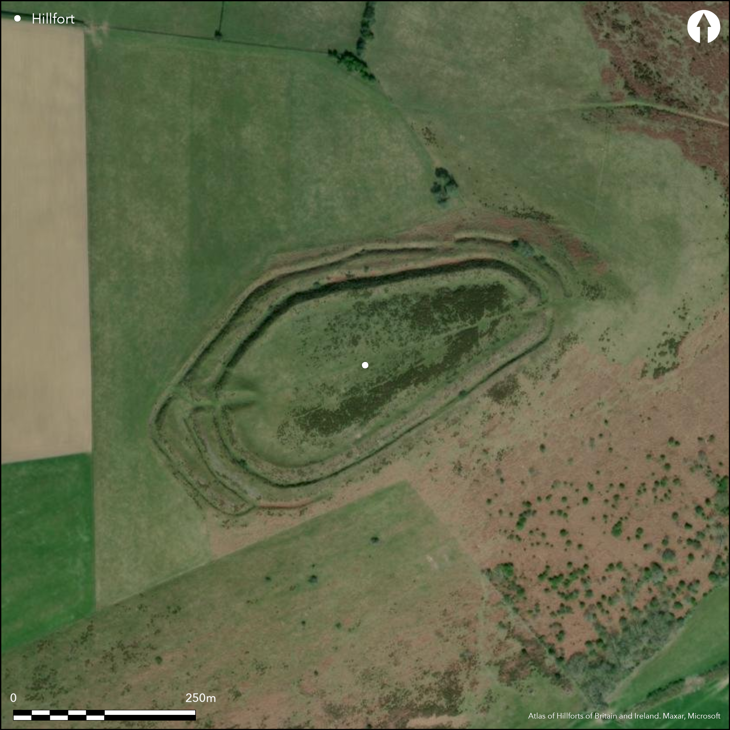
Satellite Imagery
LiDAR 1m DTM Hillshade
Satellite Imagery
Scroll left/right to view further images.
HER: Shropshire 1161 (None)
NMR: SO 37 NW 1 (109138)
SM: 1010723
NGR: SO 310758
X: 331014 Y: 275798 (OSGB36)
Fine, partial contour hillfort located on a spur overlooking the River Redlake, with the Rivers Clun to the N and Teme to the S. Tilted towards the valley of the Redlake. Measures 375m ENE-WSW by 120m transversely at E end widening to maximum of 185m towards the W end, with internal area c. 2.7ha. Defined by two banks and ditches for most of circuit, but outer bank absent on the S where there is a counterscarp, and on the W a third bank and ditch is separated from second ditch by a level space giving added protection to the S flank of the entrance. The ramparts have broad flat tops. Entrances to E and W, both inturned. The slightly staggered W entrance, on the accessible side, is heavily defended by massive widely-spaced curving ramparts up to 7m high from base of a rock-cut ditch. E entrance more simply constructed and gives out onto a narrow ridge with steep natural slopes. Possible minor offset entrance with causeway to the N across the outer ditch. About six hut platforms near the E end. Phased construction of dry-stone wall faced ramparts of flat siltstone flags, later heightened and widened by dump construction. Inner quarry ditch in parts and evidence of hut sites sheltering in the lee of the rampart. Pasture with gorse scrub in the interior. Few investigations for such a major site. On 1st Ed OS map (1885-1900).
Citizen Science: ✗
Reliability of Data: Confirmed
Reliability of Interpretation: Confirmed
X: -335610 Y: 6868368 (EPSG: 3857)
Longitude: -3.0148362115961 Latitude: 52.375829788954164 (EPSG:4326)
Country: England
Current County or Unitary Authority: Shropshire
Historic County: Shropshire
Current Parish/Community/Council/Townland: Clun
Well preserved hillfort with some stock erosion, but gorse in interior which has increased in the past 20 years poses management problems. Successful 1995 erosion repairs at W entrance.
| Extant | ✓ |
| Cropmark | ✗ |
| Likely Destroyed | ✗ |
Pasture with gorse scrub in the interior.
| Woodland | ✗ |
| Commercial Forestry Plantation | ✗ |
| Parkland | ✗ |
| Pasture (Grazing) | ✓ |
| Arable | ✗ |
| Scrub/Bracken | ✓ |
| Bare Outcrop | ✗ |
| Heather/Moorland | ✗ |
| Heath | ✗ |
| Built-up | ✗ |
| Coastal Grassland | ✗ |
| Other | ✗ |
Very good example of a partial contour fort, being tilted towards the valley of the River Redlake to the NE. Superbly sited on a spur overlooking the River Redlake with the Rivers Clun to the N and Teme to the S.
| Contour Fort | ✗ |
| Partial Contour Fort | ✓ |
| Promontory Fort | ✗ |
| Hillslope Fort | ✗ |
| Level Terrain Fort | ✗ |
| Marsh Fort | ✗ |
| Multiple Enclosure Fort | ✗ |
| Hilltop | ✗ |
| Coastal Promontory | ✗ |
| Inland Promontory | ✗ |
| Valley Bottom | ✗ |
| Knoll/Hillock/Outcrop | ✗ |
| Ridge | ✗ |
| Cliff/Plateau-edge/Scarp | ✗ |
| Hillslope | ✗ |
| Lowland | ✗ |
| Spur | ✓ |
Dominant Topographic Feature: Spur
| North | ✗ |
| Northeast | ✓ |
| East | ✗ |
| Southeast | ✗ |
| South | ✗ |
| Southwest | ✗ |
| West | ✗ |
| Northwest | ✗ |
| Level | ✗ |
Altitude: 399.0m
N/A
Probably an Iron Age site, but evidence of earlier activity as Neolithic/Bronze Age worked flints and scrapers found.
Reliability: D - None
| Pre 1200BC | ✗ |
| 1200BC - 800BC | ✗ |
| 800BC - 400BC | ✗ |
| 400BC - AD50 | ✗ |
| AD50 - AD400 | ✗ |
| AD400 - AD 800 | ✗ |
| Post AD800 | ✗ |
| Unknown | ✓ |
| Pre Hillfort: | Neolithic/Bronze Age worked flints and scrapers. |
| Post Hillfort: | None |
| Artefactual: | Neolithic/Bronze Age worked flints and scrapers found. |
In Aubrey's Monumenta Britannica (1665-1693). On 1st Ed OS map (1885-1900). Field observations Ordnance Survey 1973, 1979. Field observations Shropshire CC 1977, 1981. Field observations English Heritage 1980, 1984. Air Photograph Interpretation RCHME: Marches Uplands NMP 1993-2000. Evaluation E.A. Pearson 1995. Shropshire Council survey 2012.
| Other (1995): | Evaluation E.A. Pearson. |
| Other (2012): | Shopshire Council survey. |
| 1st Identified Written Reference (None): | Aubrey's Monumenta Britannica. |
| 1st Identified Map Depiction (None): | 1st Ed OS |
| Other (None): | Field observations OS. |
| Other (None): | Field observations Shropshire CC. |
| Other (None): | Field observations EH. |
| Other (None): | Air Photograph Interpretation RCHME: Marches Uplands NMP. |
Around six hut platforms visible at the E end of the site. Inner quarry ditch in parts and evidence of hut sites sheltering in the lee of the rampart. Neolithic/Bronze Age worked flints and scrapers found. Small conical pit, 5 m in diameter, in the centre of the site, thought to be a grain storage pit, is probably an old mineral shaft.
Stream located 0.4 km outside the fort. Collapsed shaft near centre of enclosure could possibly be a well.
| None | ✓ |
| Spring | ✗ |
| Stream | ✗ |
| Pool | ✗ |
| Flush | ✗ |
| Well | ✓ |
| Other | ✗ |
Around six hut platforms visible at the E end of the site. Inner quarry ditch in parts and evidence of hut sites sheltering in the lee of the rampart. Small conical pit, 5 m in diameter and 1.3 m deep, in the centre of the site, previously thought to be a grain storage pit, is probably an old mineral shaft.
| No Known Features | ✗ |
| Round Stone Structures | ✗ |
| Rectangular Stone Structures | ✗ |
| Curvilinear Platforms | ✓ |
| Other Roundhouse Evidence | ✓ |
| Pits | ✗ |
| Quarry Hollows | ✓ |
| Other | ✓ |
None
| No Known Excavation | ✓ |
| Pits | ✗ |
| Postholes | ✗ |
| Roundhouses | ✗ |
| Rectangular Structures | ✗ |
| Roads/Tracks | ✗ |
| Quarry Hollows | ✗ |
| Other | ✗ |
| Nothing Found | ✗ |
None
| No Known Geophysics | ✓ |
| Pits | ✗ |
| Roundhouses | ✗ |
| Rectangular Structures | ✗ |
| Roads/Tracks | ✗ |
| Quarry Hollows | ✗ |
| Other | ✗ |
| Nothing Found | ✗ |
Neolithic/Bronze Age worked flints and scrapers.
| No Known Finds | ✗ |
| Pottery | ✗ |
| Metal | ✗ |
| Metalworking | ✗ |
| Human Bones | ✗ |
| Animal Bones | ✗ |
| Lithics | ✓ |
| Environmental | ✗ |
| Other | ✗ |
None
| APs Not Checked | ✓ |
| None | ✗ |
| Roundhouses | ✗ |
| Rectangular Structures | ✗ |
| Pits | ✗ |
| Postholes | ✗ |
| Roads/Tracks | ✗ |
| Other | ✗ |
Entrances to E and W, both inturned. The slightly staggered W entrance, on the accessible side, is heavily defended by massive widely-spaced curving ramparts up to 7m high from base of a rock-cut ditch. E entrance more simply constructed and gives out onto a narrow ridge with steep natural slopes. Possible minor offset, entrance with causeway to the N across the outer ditch.
| 3: | No modern gaps in evidence. |
| 2: | Good entrances. |
Guard Chambers: ✗
Chevaux de Frise: ✗
| 1. In-turned (East): | More simply constructed than that on W. |
| 2. In-turned (West): | Slightly staggered W entrance, on the accessible side, heavily defended by massive widely-spaced curving ramparts up to 7 m high from base of a rock-cut ditch. |
| 2. Over-lapping (West): | Slightly staggered. |
| 3. Oblique (North): | Possible minor offset, or possibly oblique, entrance with causeway to the N across the outer ditch. |
Two banks and ditches for most of circuit, but outer bank absent on the S where there is a counterscarp and on the W a third bank and ditch is separated from second ditch by a level space giving added protection to the S flank of the entrance. the ramparts have broad flat tops. Phased construction of dry-stone wall faced ramparts of flat siltstone flags, later heightened and widened by dump construction.
| Area 1: | 2.7ha. |
| Total: | 2.7ha. |
Total Footprint Area: Noneha.
Two banks and ditches for most of circuit, but outer bank absent on the south where there is a counterscarp and on the west a third bank and ditch is separated from second ditch by a level space giving added protection to the south flank of the entrance. Phased construction of dry-stone wall faced ramparts of flat siltstone flags, later heightened and widened by dump construction. Ramparts have broad flat tops.
| ✓ | Phased construction of dry-stone wall faced ramparts of flat siltstone flags, later heightened and widened by dump construction. |
| ✓ | Number of ramparts vary around circuit. No details of phasing. |
| NE Quadrant: | 3 |
| SE Quadrant: | 2 |
| SW Quadrant: | 3 |
| NW Quadrant: | 3 |
| Total: | 3 |
| Partial Univallate | ✗ |
| Univallate | ✗ |
| Partial Bivallate | ✓ |
| Bivallate | ✗ |
| Partial Multivallate | ✓ |
| Multivallate | ✗ |
| Unknown | ✗ |
| Partial Univallate | ✗ |
| Univallate | ✗ |
| Partial Bivallate | ✗ |
| Bivallate | ✗ |
| Partial Multivallate | ✗ |
| Multivallate | ✗ |
Phased construction of dry-stone wall faced ramparts of flat siltstone flags, later heightened and widened by dump construction. Ramparts have broad flat tops.
| None | ✗ |
| Earthen Bank | ✓ |
| Stone Wall | ✓ |
| Rubble | ✗ |
| Wall-walk | ✗ |
| Evidence of Timber | ✗ |
| Vitrification | ✗ |
| Other Burning | ✗ |
| Palisade | ✗ |
| Counter Scarp Bank | ✓ |
| Berm | ✗ |
| Unfinished | ✗ |
| Other | ✗ |
None
| None | ✗ |
| Earthen Bank | ✗ |
| Stone Wall | ✗ |
| Murus Duplex | ✗ |
| Timber-framed | ✗ |
| Timber-laced | ✗ |
| Vitrification | ✗ |
| Other Burning | ✗ |
| Palisade | ✗ |
| Counter Scarp Bank | ✗ |
| Berm | ✗ |
| Unfinished | ✗ |
| No Known Excavation | ✓ |
| Other | ✗ |
| ✗ | None |
| ✓ | Up to three ditches in evidence. |
Number of Ditches: 3
| ✗ | None |
Dorling, P. and Wigley, A. 2012. Assessment of the archaeological and conservation status of major later prehistoric enclosures in Herefordshire and Shropshire, EH PNUM, Version 3.2, Hereford and Shrewsbury: Herefordshire Council/Shropshire Council.
Page, W. ed. 1908. Victoria County History of Shropshire, 1, 362-63, Institute of Historical Research.
Watson, M. 2002. Shropshire an archaeological guide, 23-4, plan and aerial photo, Shrewsbury: Shropshire Books.
Atlas of Hillforts:
Wikidata:
This work is licensed under CC BY-SA 4.0![]()
![]()
![]() and should be cited as:
and should be cited as:
Lock, Gary and Ralston, Ian. 2024. Atlas of Hillforts of Britain and Ireland. Available at: https://hillforts.arch.ox.ac.uk
Document Version 1.1