
LiDAR 1m DTM Hillshade
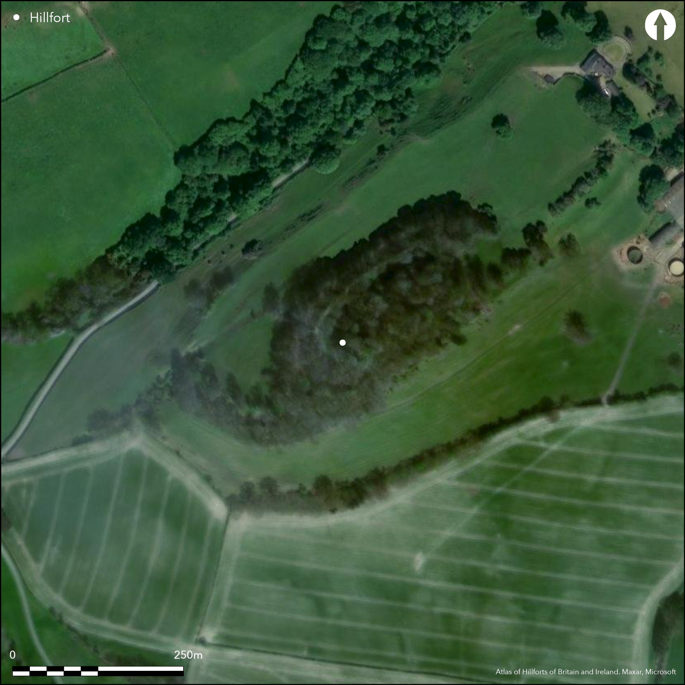
Satellite Imagery
LiDAR 1m DTM Hillshade
Satellite Imagery
Scroll left/right to view further images.
HER: Shropshire 249 (None)
NMR: SJ 30 NW 1 (66343)
SM: 1020147
NGR: SJ337078
X: 333700 Y: 307800 (OSGB36)
The buried remains of a small, multivallate, probable contour hillfort, with the structural remains of a motte and bailey castle and small medieval town or borough. Site is set on a prominent hill at the SE end of Long Mountain. Internal area c. 3.6ha. The defences are bivallate on the NW and SE and trivallate on the NE and SW, separated by ditches. Two entrances are on the E and W, with some masonry still visible, but there is another possibly on the NE. Within the enclosure the motte (15m high) and bailey castle is defended by double banks and date from about the 11th or 12th centuries, the borough having streets, two gates and two chapels of the same date. Gradiometer survey 2015. Pasture and woodland, but some ash tree colonisation and scrub causing problems to be addressed. On 1st Ed OS map (1885-1900).
Citizen Science: ✗
Reliability of Data: Confirmed
Reliability of Interpretation: Unconfirmed
X: -331930 Y: 6921054 (EPSG: 3857)
Longitude: -2.9817775012680556 Latitude: 52.663820583878724 (EPSG:4326)
Country: England
Current County or Unitary Authority: Shropshire
Historic County: Shropshire
Current Parish/Community/Council/Townland: Westbury
Pasture and woodland, but some ash tree colonisation and scrub causing problems to be addressed. Motte and bailey castle.
| Extant | ✓ |
| Cropmark | ✗ |
| Likely Destroyed | ✗ |
Pasture, wood and scrub. Motte and bailey castle.
| Woodland | ✓ |
| Commercial Forestry Plantation | ✗ |
| Parkland | ✗ |
| Pasture (Grazing) | ✓ |
| Arable | ✗ |
| Scrub/Bracken | ✓ |
| Bare Outcrop | ✗ |
| Heather/Moorland | ✗ |
| Heath | ✗ |
| Built-up | ✗ |
| Coastal Grassland | ✗ |
| Other | ✓ |
Fort follows the contours tof hill to its defensive advantage. Set on a prominent hill at the SE end of Long Mountain, overlooking the Rea Brook to the S and E and undulating lowlands to N.
| Contour Fort | ✓ |
| Partial Contour Fort | ✗ |
| Promontory Fort | ✗ |
| Hillslope Fort | ✗ |
| Level Terrain Fort | ✗ |
| Marsh Fort | ✗ |
| Multiple Enclosure Fort | ✗ |
| Hilltop | ✓ |
| Coastal Promontory | ✗ |
| Inland Promontory | ✗ |
| Valley Bottom | ✗ |
| Knoll/Hillock/Outcrop | ✗ |
| Ridge | ✗ |
| Cliff/Plateau-edge/Scarp | ✗ |
| Hillslope | ✗ |
| Lowland | ✗ |
| Spur | ✗ |
Dominant Topographic Feature: Prominent hill.
| North | ✗ |
| Northeast | ✗ |
| East | ✗ |
| Southeast | ✗ |
| South | ✗ |
| Southwest | ✗ |
| West | ✗ |
| Northwest | ✗ |
| Level | ✓ |
Altitude: 200.0m
N/A
The medieval remains are dated to the 11th and 12th centuries. The hillfort is assumed to be of Iron Age date, but its exact date is unknown.
Reliability: D - None
| Pre 1200BC | ✗ |
| 1200BC - 800BC | ✗ |
| 800BC - 400BC | ✗ |
| 400BC - AD50 | ✗ |
| AD50 - AD400 | ✗ |
| AD400 - AD 800 | ✗ |
| Post AD800 | ✗ |
| Unknown | ✓ |
| Pre Hillfort: | None |
| Post Hillfort: | Within the enclosure the motte (15m high) and bailey castle is defended by double banks and date from about the 11th or 12th centuries, the borough having streets, two gates and two chapels of the same date. |
On 1st Ed OS map (1885-1900). Field observationOrdnance Survey 1971. Field observation English heritage 1987. Air Photograph Interpretation RCHME: Marches Uplands NMP 1993-2000. ShropshireShropshire Council survey 2012. Gradiometer survey G. Carey 2015.
| Other (2012): | Shropshire Council survey. |
| Geophysical Survey (2015): | G. Carey. |
| 1st Identified Map Depiction (None): | 1st Ed OS |
| Other (None): | Air Photograph Interpretation RCHME: Marches Uplands NMP. |
None
None
| None | ✓ |
| Spring | ✗ |
| Stream | ✗ |
| Pool | ✗ |
| Flush | ✗ |
| Well | ✗ |
| Other | ✗ |
None
| No Known Features | ✓ |
| Round Stone Structures | ✗ |
| Rectangular Stone Structures | ✗ |
| Curvilinear Platforms | ✗ |
| Other Roundhouse Evidence | ✗ |
| Pits | ✗ |
| Quarry Hollows | ✗ |
| Other | ✗ |
None
| No Known Excavation | ✓ |
| Pits | ✗ |
| Postholes | ✗ |
| Roundhouses | ✗ |
| Rectangular Structures | ✗ |
| Roads/Tracks | ✗ |
| Quarry Hollows | ✗ |
| Other | ✗ |
| Nothing Found | ✗ |
No details of 2015 survey.
| No Known Geophysics | ✗ |
| Pits | ✗ |
| Roundhouses | ✗ |
| Rectangular Structures | ✗ |
| Roads/Tracks | ✗ |
| Quarry Hollows | ✗ |
| Other | ✓ |
| Nothing Found | ✗ |
None
| No Known Finds | ✓ |
| Pottery | ✗ |
| Metal | ✗ |
| Metalworking | ✗ |
| Human Bones | ✗ |
| Animal Bones | ✗ |
| Lithics | ✗ |
| Environmental | ✗ |
| Other | ✗ |
None
| APs Not Checked | ✓ |
| None | ✗ |
| Roundhouses | ✗ |
| Rectangular Structures | ✗ |
| Pits | ✗ |
| Postholes | ✗ |
| Roads/Tracks | ✗ |
| Other | ✗ |
Two entrances are on the E and W, simple gaps, with some masonry still visible, but there is another possibly on the NE, its form not determined.
| 3: | No modern gaps recorded. |
| 2: | Possibly three original entrances. |
Guard Chambers: ✗
Chevaux de Frise: ✗
| 1. Simple Gap (East): | Simple gap with some masonry still visible, |
| 2. Simple Gap (West): | Simple gap with some masonry still visible. |
| 3. Simple Gap (North east): | Form of entrance not determined and simple gap default. |
The defences are bivallate on the NW and SE and trivallate on the NE and SW, separated by ditches. Only parts of the site are visible. Some masonry, stone faces, is visible in the ditches at the entrances.
| Area 1: | 3.6ha. |
| Total: | 3.6ha. |
Total Footprint Area: Noneha.
None
| ✗ | The main enclosure is estimated only at c. 3.6 ha. |
| ✓ | Only parts of the site are visible. |
| NE Quadrant: | 3 |
| SE Quadrant: | 2 |
| SW Quadrant: | 3 |
| NW Quadrant: | 2 |
| Total: | 3 |
| Partial Univallate | ✗ |
| Univallate | ✗ |
| Partial Bivallate | ✓ |
| Bivallate | ✗ |
| Partial Multivallate | ✓ |
| Multivallate | ✗ |
| Unknown | ✗ |
| Partial Univallate | ✗ |
| Univallate | ✗ |
| Partial Bivallate | ✗ |
| Bivallate | ✗ |
| Partial Multivallate | ✗ |
| Multivallate | ✗ |
Some masonry is visible in the ditches at the entrances.
| None | ✗ |
| Earthen Bank | ✗ |
| Stone Wall | ✓ |
| Rubble | ✗ |
| Wall-walk | ✗ |
| Evidence of Timber | ✗ |
| Vitrification | ✗ |
| Other Burning | ✗ |
| Palisade | ✗ |
| Counter Scarp Bank | ✗ |
| Berm | ✗ |
| Unfinished | ✗ |
| Other | ✗ |
None
| None | ✗ |
| Earthen Bank | ✗ |
| Stone Wall | ✗ |
| Murus Duplex | ✗ |
| Timber-framed | ✗ |
| Timber-laced | ✗ |
| Vitrification | ✗ |
| Other Burning | ✗ |
| Palisade | ✗ |
| Counter Scarp Bank | ✗ |
| Berm | ✗ |
| Unfinished | ✗ |
| No Known Excavation | ✓ |
| Other | ✗ |
| ✗ | None |
| ✓ | The ditches are visible only as depressions or sloping terraces. |
Number of Ditches: 2
| ✗ | None |
Dorling, P. and Wigley, A. 2012: Assessment of the archaeological and conservation status of major later prehistoric enclosures in Herefordshire and Shropshire, EH PNUM, Version 3.2, Hereford and Shrewsbury: Herefordshire Council/Shropshire Council.
Atlas of Hillforts:
Wikidata:
This work is licensed under CC BY-SA 4.0![]()
![]()
![]() and should be cited as:
and should be cited as:
Lock, Gary and Ralston, Ian. 2024. Atlas of Hillforts of Britain and Ireland. Available at: https://hillforts.arch.ox.ac.uk
Document Version 1.1