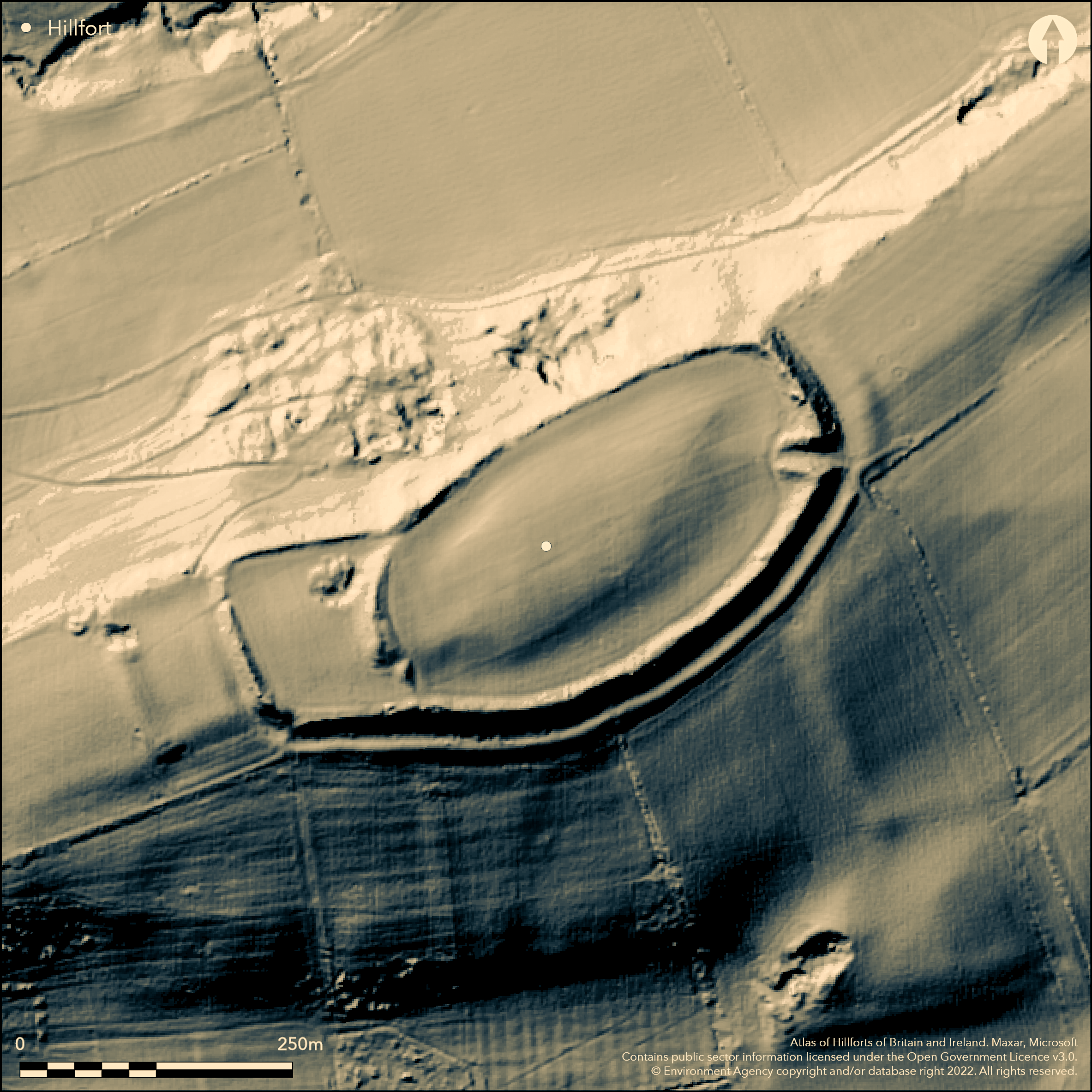
LiDAR 1m DTM Hillshade

Satellite Imagery
LiDAR 1m DTM Hillshade
Satellite Imagery
Scroll left/right to view further images.
HER: Shropshire 419 (None)
NMR: SO 57 SW 13 (111086)
SM: 1010313
NGR: SO 544737
X: 354509 Y: 273723 (OSGB36)
Oval, contour hillfort located on a small, domed and low hill summit above and overlooking the narrow valley of Ledwyche Brook to the W and Caynham Brook to the N and near to the confluence of the Rivers Teme and Corve at Ludlow. This is a fine example of a univallate fort in good order. On E side impressive, part tree-clad rampart up to 5.5m in height with 4m wide ditch and counterscarp bank. On N side, where slope steepest, rampart slight or missing. Excavation showed three phases of rampart construction: Phase I, the earliest, defences to timber-laced of c. 390 BC, replaced in Phase II by smaller stone revetted bank and later in Phase III by present massive defences. Main entrance fine and inturned, with narrow 3m wide passageway for 40m through the ramparts. Bank at W end of interior crosses from N to S. Probably originally the W extremity of the fort, an extension of the S rampart to W and N constructed to form an annexe. Although entrance gaps to this enclosure exist from main E part of site, there appears to be no obvious entrance into it from the perimeter suggesting that the whole hillfort was used as a complete entity. However, this enclosure was later extended itself to the W to form another annexe, with a bank averaging now 2.1m high. There was a possible original entrance to this from outside the perimeter near the NW corner. Excavation by P.S. Gelling 1957-61 when post-holes and unusual semi-circular possible structures found. General pasture interior with part tree-clad on inner ramparts to the N. Fort is in good condition. On 1st Ed. OS map (1885).
Citizen Science: ✗
Reliability of Data: Confirmed
Reliability of Interpretation: Confirmed
X: -297161 Y: 6865415 (EPSG: 3857)
Longitude: -2.6694464579598756 Latitude: 52.35963550308075 (EPSG:4326)
Country: England
Current County or Unitary Authority: Shropshire
Historic County: Shropshire
Current Parish/Community/Council/Townland: Caynham
Fine example of a univallate fort in good condition. Management plan for trees in operation with public access footpath and interpretation. Post-medieval quarry in W just beyond the inner rampart. Some erosion on N rampart top exposing dry-stone walling. Pasture and part tree-clad on inner ramparts to the N. Windthrow has occurred in the past. Some fencing on ramparts.
| Extant | ✓ |
| Cropmark | ✗ |
| Likely Destroyed | ✗ |
General pasture interior with part tree-clad on inner ramparts to the N. Quarrying.
| Woodland | ✗ |
| Commercial Forestry Plantation | ✗ |
| Parkland | ✗ |
| Pasture (Grazing) | ✓ |
| Arable | ✗ |
| Scrub/Bracken | ✓ |
| Bare Outcrop | ✗ |
| Heather/Moorland | ✗ |
| Heath | ✗ |
| Built-up | ✗ |
| Coastal Grassland | ✗ |
| Other | ✓ |
The rampart follows the contours. Located on a small, domed land ow hill summit above and overlooking the narrow valley of Ledwyche Brook to the W and Caynham Brook to the N, and near to the confluence of the Rivers Teme and Corve at Ludlow.
| Contour Fort | ✓ |
| Partial Contour Fort | ✗ |
| Promontory Fort | ✗ |
| Hillslope Fort | ✗ |
| Level Terrain Fort | ✗ |
| Marsh Fort | ✗ |
| Multiple Enclosure Fort | ✗ |
| Hilltop | ✓ |
| Coastal Promontory | ✗ |
| Inland Promontory | ✗ |
| Valley Bottom | ✗ |
| Knoll/Hillock/Outcrop | ✗ |
| Ridge | ✗ |
| Cliff/Plateau-edge/Scarp | ✗ |
| Hillslope | ✗ |
| Lowland | ✗ |
| Spur | ✗ |
Dominant Topographic Feature: Small domed low hill.
| North | ✗ |
| Northeast | ✗ |
| East | ✗ |
| Southeast | ✗ |
| South | ✗ |
| Southwest | ✗ |
| West | ✗ |
| Northwest | ✗ |
| Level | ✓ |
Altitude: 174.0m
N/A
Excavation by P. Gelling 1957-61 found original timber-laced rampart dated to c. 390 BC of the Phase I hillfort replaced by a smaller stone revetted bank and then in Phase III by the massive earth and stone bank of today. Charcoal from ditch associated with timber-laced rampart. C14 from Gelling excavation.
Reliability: B - Medium
| Pre 1200BC | ✗ |
| 1200BC - 800BC | ✗ |
| 800BC - 400BC | ✗ |
| 400BC - AD50 | ✓ |
| AD50 - AD400 | ✗ |
| AD400 - AD 800 | ✗ |
| Post AD800 | ✗ |
| Unknown | ✗ |
| Pre Hillfort: | None |
| Post Hillfort: | None |
| C14: | P. Gelling excavation 1957-61. |
| Morphology/Earthwork/Typology: | None |
On 1st Ed. OS map (1885). Excavation by P.S. Gelling 1957-61. Field observation Shropshire CC 1981. Field observation English Heritage 1981, 1988. Dowsing survey 1994. Air Photograph Interpretation RCHME: Marches Uplands NMP 1993-2000. Shropshire Council survey 2012.
| 1st Identified Map Depiction (1885): | OS map. |
| Other (1968): | Visit by Hillfort Study Group |
| Other (1981): | Field observation Shropshire CC. |
| Other (1994): | Dowsing survey. |
| Other (2012): | Shropshire Council survey 2012. |
| Excavation (None): | Excavation by P.S. Gelling. |
| Other (None): | Field observation EH. |
| Other (None): | Air Photograph Interpretation RCHME: Marches Uplands NMP 1993-2000. |
No evidence of occupation is visible in the interior, but many post-holes and unusual semi-circular possible structures found. Paucity of finds, but few sherds of Malvernian and Clee Hills pottery. Some carbonised grain.
Ledwyche Brook located 0.3 km outside the hillfort.
| None | ✓ |
| Spring | ✗ |
| Stream | ✗ |
| Pool | ✗ |
| Flush | ✗ |
| Well | ✗ |
| Other | ✗ |
None
| No Known Features | ✓ |
| Round Stone Structures | ✗ |
| Rectangular Stone Structures | ✗ |
| Curvilinear Platforms | ✗ |
| Other Roundhouse Evidence | ✗ |
| Pits | ✗ |
| Quarry Hollows | ✗ |
| Other | ✗ |
Many post-holes and unusual semi-circular possible structures found in the interior.
| No Known Excavation | ✗ |
| Pits | ✗ |
| Postholes | ✓ |
| Roundhouses | ✗ |
| Rectangular Structures | ✗ |
| Roads/Tracks | ✗ |
| Quarry Hollows | ✗ |
| Other | ✓ |
| Nothing Found | ✗ |
None
| No Known Geophysics | ✓ |
| Pits | ✗ |
| Roundhouses | ✗ |
| Rectangular Structures | ✗ |
| Roads/Tracks | ✗ |
| Quarry Hollows | ✗ |
| Other | ✗ |
| Nothing Found | ✗ |
Few finds - few sherds of Malvernian and Clee Hills pottery. Some carbonised grain.
| No Known Finds | ✗ |
| Pottery | ✓ |
| Metal | ✗ |
| Metalworking | ✗ |
| Human Bones | ✗ |
| Animal Bones | ✗ |
| Lithics | ✗ |
| Environmental | ✓ |
| Other | ✗ |
None
| APs Not Checked | ✓ |
| None | ✗ |
| Roundhouses | ✗ |
| Rectangular Structures | ✗ |
| Pits | ✗ |
| Postholes | ✗ |
| Roads/Tracks | ✗ |
| Other | ✗ |
The deeply inturned narrow passage at the SE corner is the original main entrance, 40m long and 3m wide. No other modern gaps visible, but a possible original entrance through the NW corner of the far W annexe could be the result of post-medieval limestone quarrying. No obvious entrance into inner annexe from perimeter suggests that whole hillfort used as a complete entity, but gaps exist into main enclosure. There was a possible original entrance into outer W annexe from outside the perimeter near the NW corner.
| 2: | Complex sequence of entrances from two annexes and outside. No other modern gaps appear visible. |
| 2: | On NW possible original entrance could be result of post-medieval limestone quarrying. |
Guard Chambers: ✗
Chevaux de Frise: ✗
| 1. In-turned (South east): | Inturned with deeply inturned narrow passage. |
| 1. Passage-way/Corridor (South east): | Inturned with deeply inturned narrow passage. |
| 2. Simple Gap (North west): | Possibly original, but could be result of post-medieval limestone quarrying. |
| 3. Simple Gap (West): | No obvious entrance into inner annexe from perimeter suggests that whole hillfort used as a complete entity, but gaps exist into main enclosure. |
On E side the impressive, part tree-clad rampart is up to 5.5m in height with a 4m wide ditch and counterscarp bank. On the N side where the slope is steepest, the rampart is slight or missing. Excavation showed three phases of rampart construction: Phase I showed the earliest defences to be timber-laced of c. 390 BC, replaced in Phase II by a smaller stone revetted bank and later in Phase III by the the present massive defences.
| Area 1: | 4.0ha. |
| Total: | 4.0ha. |
Total Footprint Area: Noneha.
None
| ✓ | Multiple phased construction. Phase I, the earliest, defences to timber-laced of c. 390 BC, replaced in Phase II by smaller stone revetted bank and later in Phase III by present massive defences. |
| ✗ | On the N side where the slope is steepest, the rampart is slight or absent. Although seemingly phased annexes to W, site defined as one entity for quadrant purposes. |
| NE Quadrant: | 1 |
| SE Quadrant: | 1 |
| SW Quadrant: | 1 |
| NW Quadrant: | 1 |
| Total: | 1 |
| Partial Univallate | ✗ |
| Univallate | ✓ |
| Partial Bivallate | ✗ |
| Bivallate | ✗ |
| Partial Multivallate | ✗ |
| Multivallate | ✗ |
| Unknown | ✗ |
| Partial Univallate | ✗ |
| Univallate | ✗ |
| Partial Bivallate | ✗ |
| Bivallate | ✗ |
| Partial Multivallate | ✗ |
| Multivallate | ✗ |
Earthen and stone construction to Phase III rampart. Counterscarp bank surrounds site. Some erosion on the N rampart top exposing dry-stone walling.
| None | ✗ |
| Earthen Bank | ✓ |
| Stone Wall | ✓ |
| Rubble | ✗ |
| Wall-walk | ✗ |
| Evidence of Timber | ✗ |
| Vitrification | ✗ |
| Other Burning | ✗ |
| Palisade | ✗ |
| Counter Scarp Bank | ✓ |
| Berm | ✗ |
| Unfinished | ✗ |
| Other | ✗ |
Timber-lacing to Phase I rampart. Stone revetted bank to Phase II and earthen and stone construction to Phase III rampart.
| None | ✗ |
| Earthen Bank | ✓ |
| Stone Wall | ✓ |
| Murus Duplex | ✗ |
| Timber-framed | ✗ |
| Timber-laced | ✓ |
| Vitrification | ✗ |
| Other Burning | ✗ |
| Palisade | ✗ |
| Counter Scarp Bank | ✗ |
| Berm | ✗ |
| Unfinished | ✗ |
| No Known Excavation | ✗ |
| Other | ✗ |
| ✗ | None |
| ✓ | Good ditches visible throughout site. |
Number of Ditches: 1
| ✓ | There are two, possibly phased, annexes located next to each other at the W end of the hillfort. A bank at the W end of the interior crosses the fort from N to S. Probably originally the W extremity of the fort, an extension of the S rampart to the W and N was constructed to form an annexe. Although entrance gaps to this enclosure exist from the main E part of the site, there appearing to be no obvious entrance into it from the perimeter suggests that the whole hillfort was used as a complete entity. However, this enclosure was later extended itself to the W to form another annexe, with a bank averaging now 2.1m high. There was a possible original entrance to this from outside the perimeter near the NW corner. |
Dorling, P. and Wigley, A. 2012. Assessment of the archaeological and conservation status of major later prehistoric enclosures in Herefordshire and Shropshire, EH PNUM, Version 3.2, Hereford and Shrewsbury: Herefordshire Council/Shropshire Council.
Gelling, P.S. 1959. Excavations at Caynham Camp near Ludlow, First Interim Report, Trans Woolhope Natur Fld Club, 56, 2, 145-48.
Gelling, P.S. 1961. Excavations at Caynham Camp, Trans Shropshire Archaeol Hist Soc, 56, 1957-60, 218-27.
Gelling, P.S. 1966. Excavations at Caynham Camp near Ludlow, Trans Shropshire Archaeol Hist Soc, 57, 1961-64, 91-100.
Atlas of Hillforts:
Wikidata:
This work is licensed under CC BY-SA 4.0![]()
![]()
![]() and should be cited as:
and should be cited as:
Lock, Gary and Ralston, Ian. 2024. Atlas of Hillforts of Britain and Ireland. Available at: https://hillforts.arch.ox.ac.uk
Document Version 1.1