LiDAR 1m DTM Hillshade
Satellite Imagery
LiDAR 1m DTM Hillshade
Satellite Imagery
Scroll left/right to view further images.
HER: Shropshire 433 (None)
NMR: SO 79 NE 3 (114486)
SM: 1021065
NGR: SO 786967
X: 378662 Y: 296702 (OSGB36)
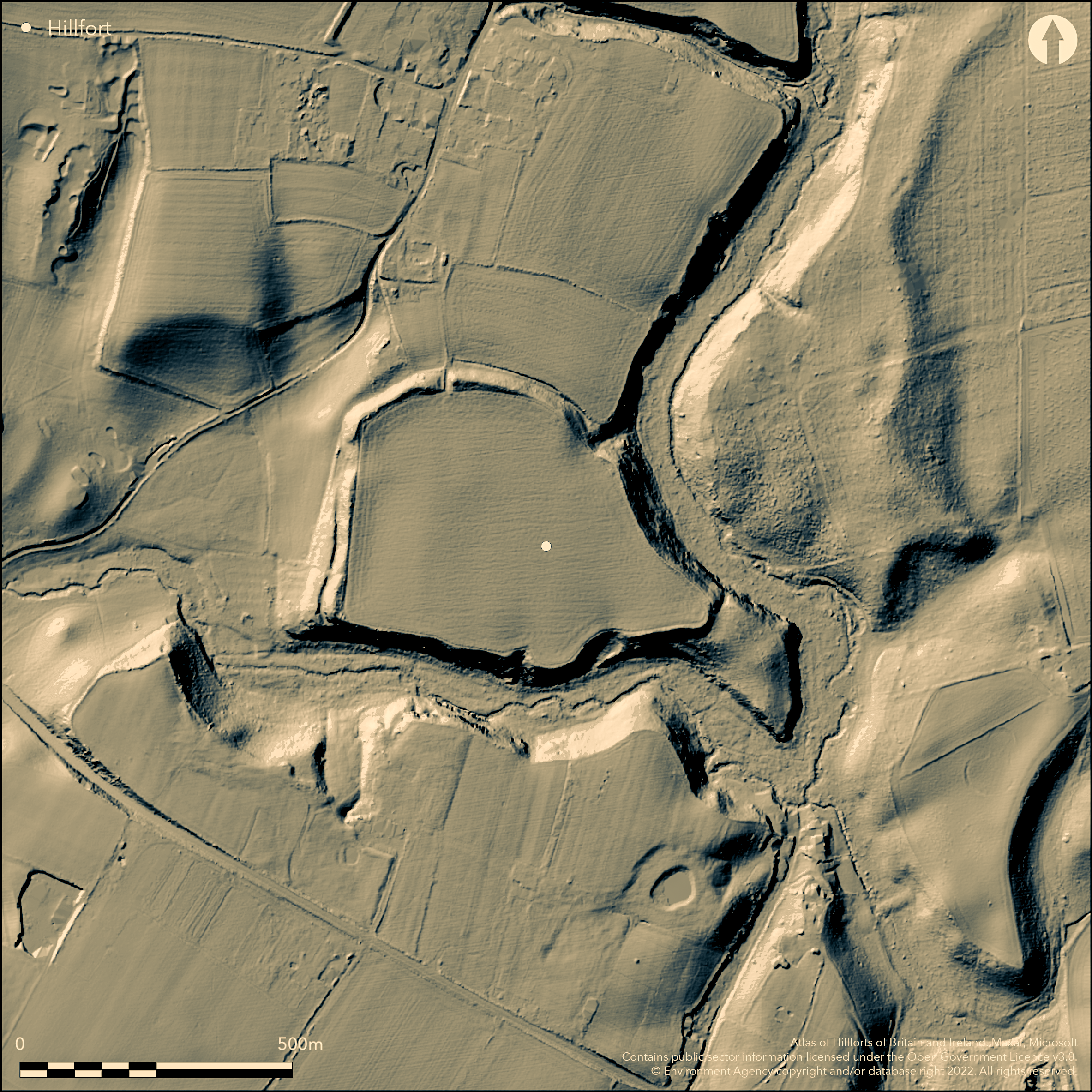
Large, contour hillfort located within a steep-sided bend at confluence of Stratford Brook and another stream, tributaries of the River Worfe. Defended on N and W by bank and ditch, on NE by rampart on the crest of the slope, and on S by precipitous hillside. Rampart strongest on N, where rises 2m+ above interior and falls some 9m+ to deep 3m ditch. In middle of N side is a simple original entrance, with another, but modern, gap at its E end. A tongue of land at the streams junction to the SE, and separated from the main enclosure by a bank c. 4m+ high, forms an annexe. Interior has been under intensive arable for many years and unlikely to be altered at present. Annexe, banks and slopes are tree covered, undergrowth dense in places. Traces of modern stone wall along the bank, particularly on E side. Undated. On 1st Ed OS map (1885-1900).
Citizen Science: ✗
Reliability of Data: Confirmed
Reliability of Interpretation: Confirmed
X: -257845 Y: 6903430 (EPSG: 3857)
Longitude: -2.3162590500780573 Latitude: 52.567694287891825 (EPSG:4326)
Country: England
Current County or Unitary Authority: Shropshire
Historic County: Shropshire
Current Parish/Community/Council/Townland: Worfield
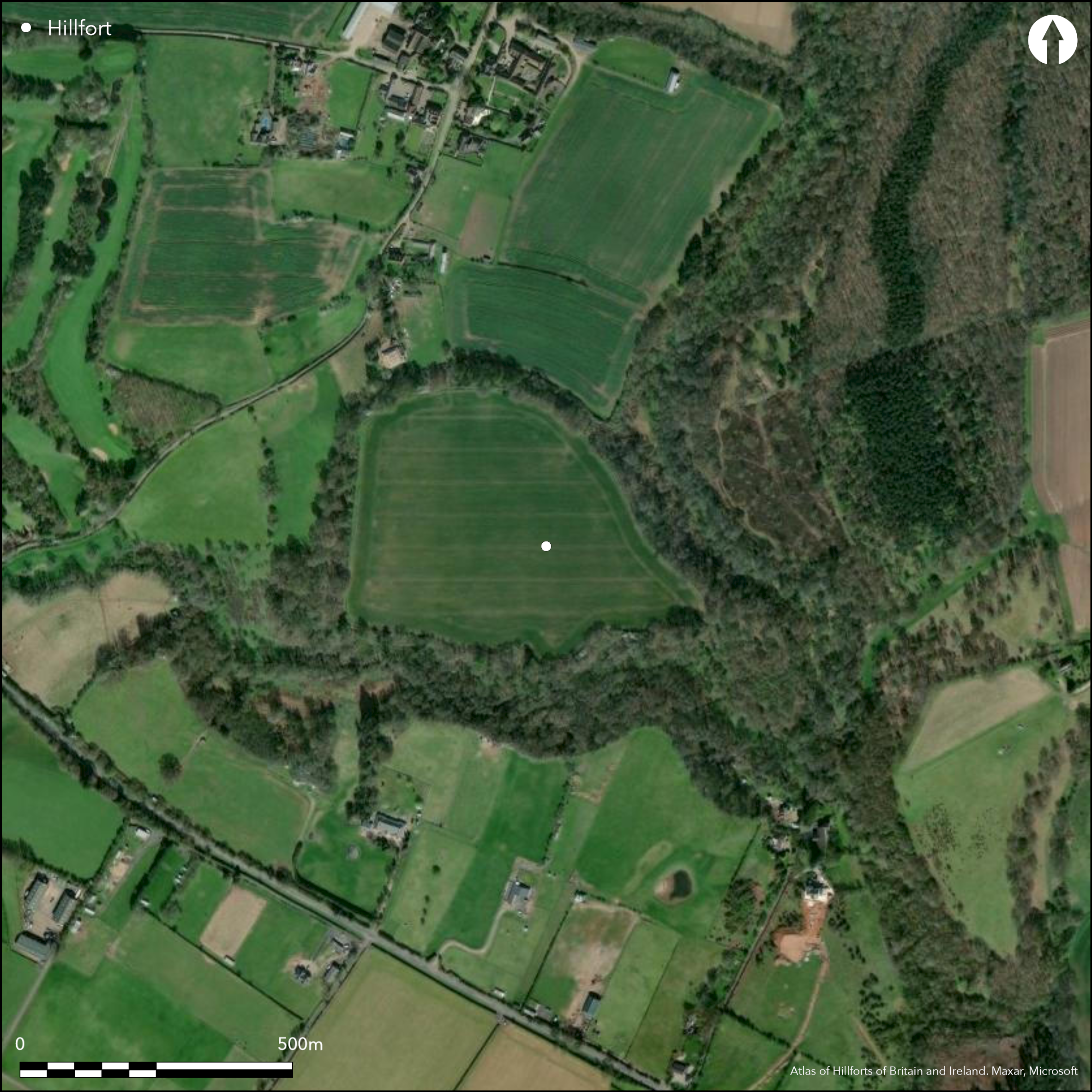
Intensive arable in interior with mature woodland on ramparts has damaged the site. Site unlikely to return to pasture in the foreseeable future.
| Extant | ✓ |
| Cropmark | ✗ |
| Likely Destroyed | ✗ |
Intensive arable in the interior, with mature woodland with scrub understorey on the ramparts. Scrub and woodland in annexe.
| Woodland | ✓ |
| Commercial Forestry Plantation | ✗ |
| Parkland | ✗ |
| Pasture (Grazing) | ✗ |
| Arable | ✓ |
| Scrub/Bracken | ✓ |
| Bare Outcrop | ✗ |
| Heather/Moorland | ✗ |
| Heath | ✗ |
| Built-up | ✗ |
| Coastal Grassland | ✗ |
| Other | ✗ |
Contour hillfort sited within a steep-sided bend at the confluence of Stratford Brook and another stream, tributaries of the River Worfe.
| Contour Fort | ✓ |
| Partial Contour Fort | ✗ |
| Promontory Fort | ✗ |
| Hillslope Fort | ✗ |
| Level Terrain Fort | ✗ |
| Marsh Fort | ✗ |
| Multiple Enclosure Fort | ✗ |
| Hilltop | ✗ |
| Coastal Promontory | ✗ |
| Inland Promontory | ✗ |
| Valley Bottom | ✗ |
| Knoll/Hillock/Outcrop | ✗ |
| Ridge | ✗ |
| Cliff/Plateau-edge/Scarp | ✗ |
| Hillslope | ✗ |
| Lowland | ✗ |
| Spur | ✓ |
Dominant Topographic Feature: Steep-sided spur on bend at the confluence of Stratford Brook and another stream,
| North | ✗ |
| Northeast | ✗ |
| East | ✗ |
| Southeast | ✗ |
| South | ✗ |
| Southwest | ✗ |
| West | ✗ |
| Northwest | ✗ |
| Level | ✓ |
Altitude: 70.0m
N/A
Roman coins found. Site possibly Iron Age by morphology.
Reliability: D - None
| Pre 1200BC | ✗ |
| 1200BC - 800BC | ✗ |
| 800BC - 400BC | ✗ |
| 400BC - AD50 | ✗ |
| AD50 - AD400 | ✗ |
| AD400 - AD 800 | ✗ |
| Post AD800 | ✗ |
| Unknown | ✓ |
| Pre Hillfort: | None |
| Post Hillfort: | Possibly Roman re-use |
| Artefactual: | Roman coins found. |
On 1st Ed OS map (1885-1900). Field observation Ordnance Survey 1979. Field observation English Heritage 1972, 1979, 1982. Field observation Shropshire CC 1981. Air Photograph Interpretation RCHME: Marches Uplands NMP 1993-2000. Shropshire Council survey 2012.
| Other (1979): | Fields observation OS. |
| Other (1981): | Field observation Shropshire CC. |
| Other (2012): | Shropshire Council survey. |
| 1st Identified Map Depiction (None): | 1st Ed OS |
| Other (None): | Field observation EH. |
| Other (None): | Air Photograph Interpretation RCHME: Marches Uplands NMP. |
Roman coins and a gold ring set with lapius lazuli, of uncertain date, are the only stray finds from the site.
None
| None | ✓ |
| Spring | ✗ |
| Stream | ✗ |
| Pool | ✗ |
| Flush | ✗ |
| Well | ✗ |
| Other | ✗ |
None
| No Known Features | ✓ |
| Round Stone Structures | ✗ |
| Rectangular Stone Structures | ✗ |
| Curvilinear Platforms | ✗ |
| Other Roundhouse Evidence | ✗ |
| Pits | ✗ |
| Quarry Hollows | ✗ |
| Other | ✗ |
None
| No Known Excavation | ✓ |
| Pits | ✗ |
| Postholes | ✗ |
| Roundhouses | ✗ |
| Rectangular Structures | ✗ |
| Roads/Tracks | ✗ |
| Quarry Hollows | ✗ |
| Other | ✗ |
| Nothing Found | ✗ |
None
| No Known Geophysics | ✓ |
| Pits | ✗ |
| Roundhouses | ✗ |
| Rectangular Structures | ✗ |
| Roads/Tracks | ✗ |
| Quarry Hollows | ✗ |
| Other | ✗ |
| Nothing Found | ✗ |
Roman coins and a gold ring set with lapius lazuli, of uncertain date, are the only finds from the site.
| No Known Finds | ✗ |
| Pottery | ✗ |
| Metal | ✗ |
| Metalworking | ✗ |
| Human Bones | ✗ |
| Animal Bones | ✗ |
| Lithics | ✗ |
| Environmental | ✗ |
| Other | ✓ |
None
| APs Not Checked | ✓ |
| None | ✗ |
| Roundhouses | ✗ |
| Rectangular Structures | ✗ |
| Pits | ✗ |
| Postholes | ✗ |
| Roads/Tracks | ✗ |
| Other | ✗ |
Original entrance midway along the N side, simple gap. One modern gap at E end of N side.
| 2: | One modern gap at E end of N side. |
| 2: | Original entrance midway along the N side. |
Guard Chambers: ✗
Chevaux de Frise: ✗
| 1. Simple Gap (North): | Located midway along the N side. |
The fort is defended on the N and W by a bank and ditch, on the NE by a rampart on the crest of the slope, and on the S by a precipitous hillside. The rampart is strongest on the N, where it rises 2 m + above the interior and falls some 9m+ to a deep 3m ditch.
| Area 1: | 9.4ha. |
| Total: | 9.4ha. |
Total Footprint Area: Noneha.
None
| ✗ | Enclosed area includes annexe. |
| ✓ | S is protected by a precipitous hillside. |
| NE Quadrant: | 1 |
| SE Quadrant: | 0 |
| SW Quadrant: | 1 |
| NW Quadrant: | 1 |
| Total: | 1 |
| Partial Univallate | ✓ |
| Univallate | ✗ |
| Partial Bivallate | ✗ |
| Bivallate | ✗ |
| Partial Multivallate | ✗ |
| Multivallate | ✗ |
| Unknown | ✗ |
| Partial Univallate | ✗ |
| Univallate | ✗ |
| Partial Bivallate | ✗ |
| Bivallate | ✗ |
| Partial Multivallate | ✗ |
| Multivallate | ✗ |
None
| None | ✗ |
| Earthen Bank | ✓ |
| Stone Wall | ✗ |
| Rubble | ✗ |
| Wall-walk | ✗ |
| Evidence of Timber | ✗ |
| Vitrification | ✗ |
| Other Burning | ✗ |
| Palisade | ✗ |
| Counter Scarp Bank | ✗ |
| Berm | ✗ |
| Unfinished | ✗ |
| Other | ✗ |
None
| None | ✗ |
| Earthen Bank | ✗ |
| Stone Wall | ✗ |
| Murus Duplex | ✗ |
| Timber-framed | ✗ |
| Timber-laced | ✗ |
| Vitrification | ✗ |
| Other Burning | ✗ |
| Palisade | ✗ |
| Counter Scarp Bank | ✗ |
| Berm | ✗ |
| Unfinished | ✗ |
| No Known Excavation | ✓ |
| Other | ✗ |
| ✗ | None |
| ✓ | The ditch on N side smoothed down by ploughing. |
Number of Ditches: 1
| ✓ | A tongue of land at the streams junction to the SE, and separated from the main enclosure by a bank c. 4 m+ high, forms an annexe. |
Dorling, P. and Wigley, A. 2012. Assessment of the archaeological and conservation status of major later prehistoric enclosures in Herefordshire and Shropshire, EH PNUM, Version 3.2, Hereford and Shrewsbury: Herefordshire Council/Shropshire Council.
Page, W. ed. 1908. Victoria County History of Shropshire, 1, 377-78, Institute of Historical Research.
Atlas of Hillforts:
Wikidata:
This work is licensed under CC BY-SA 4.0![]()
![]()
![]() and should be cited as:
and should be cited as:
Lock, Gary and Ralston, Ian. 2024. Atlas of Hillforts of Britain and Ireland. Available at: https://hillforts.arch.ox.ac.uk
Document Version 1.1