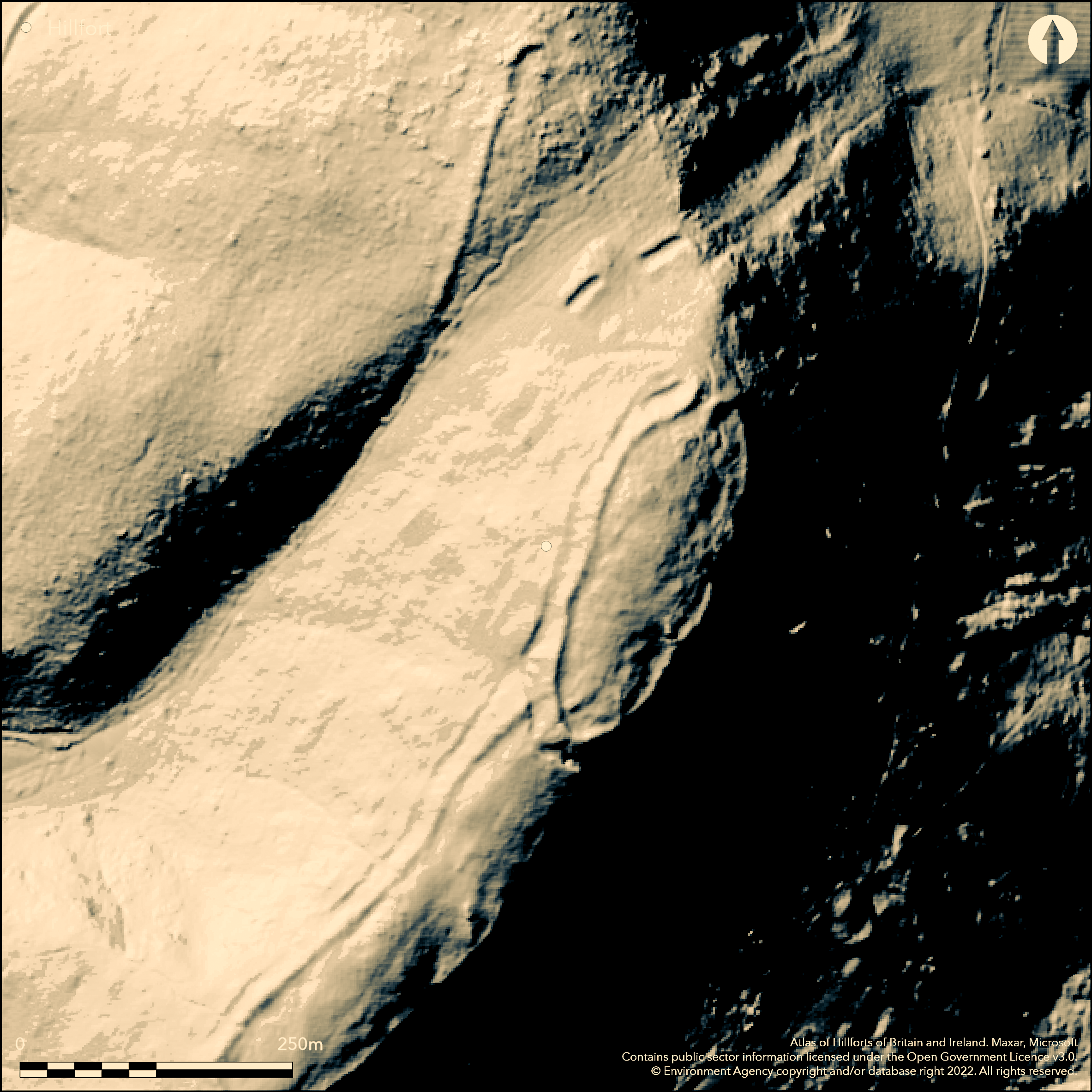
LiDAR 1m DTM Hillshade
Satellite Imagery
LiDAR 1m DTM Hillshade
Satellite Imagery
Scroll left/right to view further images.
HER: Shropshire 1050 (None)
NMR: SJ 40 SW 1 (67797)
SM: 1020152
NGR: SJ 40880483
X: 340889 Y: 304836 (OSGB36)
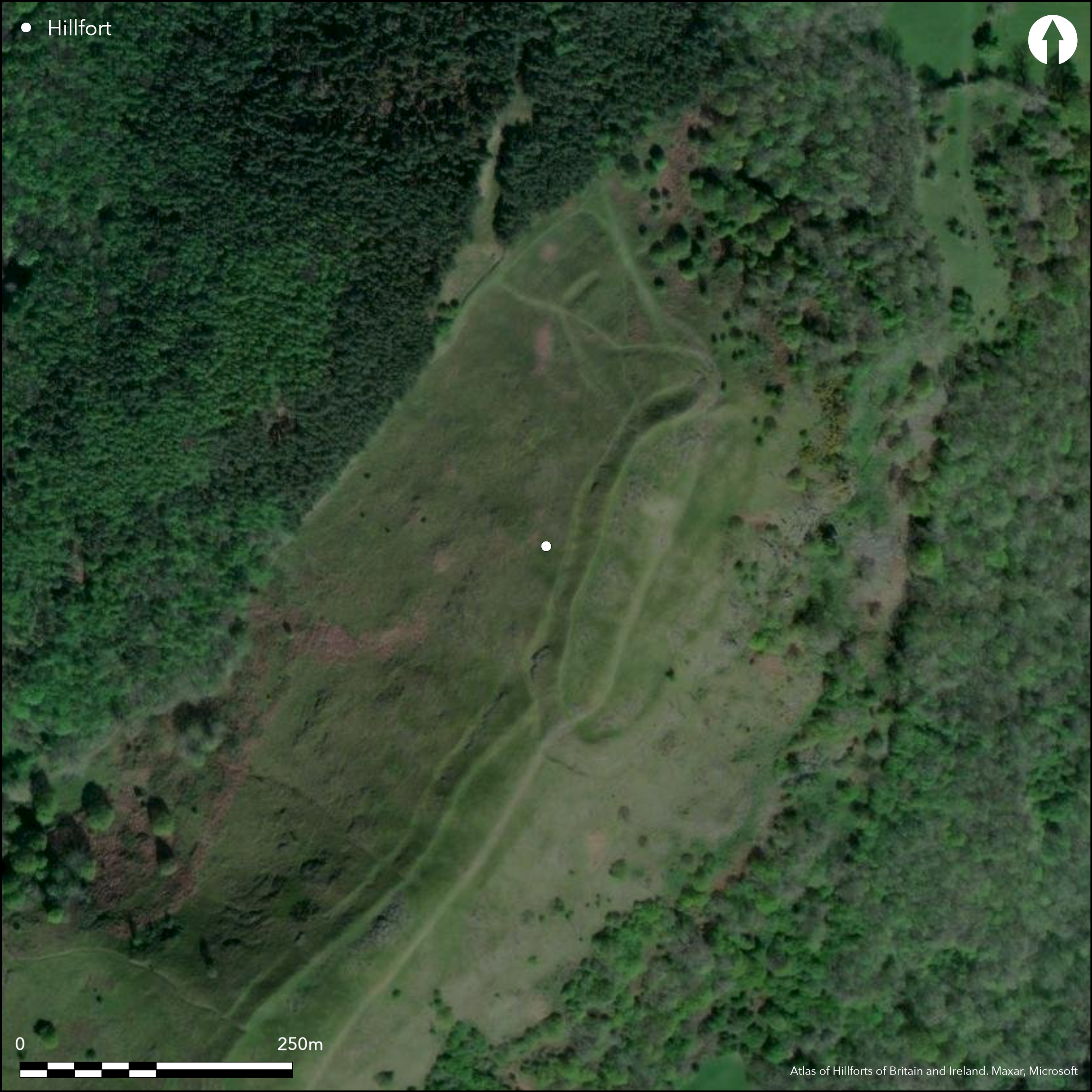
Partial contour hillfort crowning the steep summit and S slopes of Pontesford Hill with far-reaching views commanding the valleys of the Rea and Cound Brooks. Elongated shape, with internal area c. 2.8ha. A main enclosure, created by cutting into the hillside, has a single flat topped rampart and ditch encloses 1.1ha, apart from on the E where the slope is at its most precipitous, and with a slight counterscarp bank to the NW and upper and lower berms to the W. Evidence of a counterscarp bank on the NW. Simple gap in the rampart on the S, over a causeway/ ditch, reaches a 1.7ha elongated possible annexe or addition to site, defended on the S and W by a bank up to 6m high, with intermittent berm and counterscarp bank and ditch to S corner. As with the main enclosure, E is well-defended by precipitous slopes. Entrance to main enclosure is to the NE, with causeway and terrace cutting into the precipitous hillside, with inturn and out-turns to the banks. Outside the main enclosure to the N are two outworks of ditch and bank, with a further outwork 70m beyond these of substantial banks and inturned entrance to the N. These outworks are undated and the largest has been scheduled as a cross-dyke. This could represent an aborted earlier enclosure or possible enhancements to the vulnerable N side of the hill. Possible hut platforms on E and vitrified material. Evidence of WWII activity. Site in good condition and well managed, with small excavation on summit in 2011. On 1st Ed. OS map (1882).
Citizen Science: ✗
Reliability of Data: Confirmed
Reliability of Interpretation: Confirmed
X: -320039 Y: 6916318 (EPSG: 3857)
Longitude: -2.8749611368087526 Latitude: 52.63801048918132 (EPSG:4326)
Country: England
Current County or Unitary Authority: Shropshire
Historic County: Shropshire
Current Parish/Community/Council/Townland: Pontesbury
Good management by Shropshire Wildlife Trust as a nature reserve and well preserved. Some rabbit and visitor erosion.
| Extant | ✓ |
| Cropmark | ✗ |
| Likely Destroyed | ✗ |
Upland pasture with bare rock outcrops. Possible WWII emplacement.
| Woodland | ✗ |
| Commercial Forestry Plantation | ✗ |
| Parkland | ✗ |
| Pasture (Grazing) | ✓ |
| Arable | ✗ |
| Scrub/Bracken | ✗ |
| Bare Outcrop | ✗ |
| Heather/Moorland | ✗ |
| Heath | ✗ |
| Built-up | ✗ |
| Coastal Grassland | ✗ |
| Other | ✓ |
Partial contour hillfort occupies prominent hill top and associated ridge, crowning the steep summit and S slopes of Pontesford Hill with far-reaching views commanding the valleys of the Rea and Cound Brooks.
| Contour Fort | ✗ |
| Partial Contour Fort | ✓ |
| Promontory Fort | ✗ |
| Hillslope Fort | ✗ |
| Level Terrain Fort | ✗ |
| Marsh Fort | ✗ |
| Multiple Enclosure Fort | ✗ |
| Hilltop | ✓ |
| Coastal Promontory | ✗ |
| Inland Promontory | ✗ |
| Valley Bottom | ✗ |
| Knoll/Hillock/Outcrop | ✗ |
| Ridge | ✓ |
| Cliff/Plateau-edge/Scarp | ✗ |
| Hillslope | ✗ |
| Lowland | ✗ |
| Spur | ✗ |
Dominant Topographic Feature: Pontesford Hill summit.
| North | ✗ |
| Northeast | ✗ |
| East | ✗ |
| Southeast | ✗ |
| South | ✓ |
| Southwest | ✗ |
| West | ✗ |
| Northwest | ✗ |
| Level | ✗ |
Altitude: 320.0m
N/A
Probably of Iron Age date with evidence of WWII activity.
Reliability: D - None
| Pre 1200BC | ✗ |
| 1200BC - 800BC | ✗ |
| 800BC - 400BC | ✗ |
| 400BC - AD50 | ✗ |
| AD50 - AD400 | ✗ |
| AD400 - AD 800 | ✗ |
| Post AD800 | ✗ |
| Unknown | ✓ |
| Pre Hillfort: | None |
| Post Hillfort: | Evidence of WWII emplacement. |
| Other: | Evidence of WWII emplacement. |
On 1st Ed. OS map (1882). Field observation Ordnance Survey 1971. Field observation English Heritage 1981, 1987. Field observation Shropshire CC 1978. Condition survey and management plan for Earl's Hill Nature Reserve 1998. Small indeterminate investigation on summit in 2011 to investigate possible gully on the summit of the hill. Air Photograph Interpretation RCHME: Marches Uplands NMP 1993-2000. Shropshire Council survey 2012.
| 1st Identified Map Depiction (1882): | OS map. |
| Other (1971): | Field observation OS. |
| Other (1978): | Field observation Shropshire CC. |
| Other (1998): | Condition survey and management plan for Earl's Hill Nature Reserve. |
| Other (2009): | Visited by Hillfort Study Group |
| Excavation (2011): | Small excavation on summit by A. Wigley and G. Guilbert. |
| Other (2012): | Shropshire Council Survey. |
| Other (None): | Field observation EH. |
| Other (None): | Air Photograph Interpretation RCHME: Marches Uplands NMP. |
Possible hut platforms visible. Small indeterminate excavation on summit 2011 to determine origin of possible gully. Possible evidence of vitrification. Half of an undated bronze ring and flint flakes chance finds, now in Shrewsbury Museum.
Stream located 0.3 km outside the fort.
| None | ✓ |
| Spring | ✗ |
| Stream | ✗ |
| Pool | ✗ |
| Flush | ✗ |
| Well | ✗ |
| Other | ✗ |
Possible hut platforms visible.
| No Known Features | ✗ |
| Round Stone Structures | ✗ |
| Rectangular Stone Structures | ✗ |
| Curvilinear Platforms | ✓ |
| Other Roundhouse Evidence | ✗ |
| Pits | ✗ |
| Quarry Hollows | ✗ |
| Other | ✗ |
Small indeterminate excavation on summit 2011 to determine origin of possible gully.
| No Known Excavation | ✗ |
| Pits | ✗ |
| Postholes | ✗ |
| Roundhouses | ✗ |
| Rectangular Structures | ✗ |
| Roads/Tracks | ✗ |
| Quarry Hollows | ✗ |
| Other | ✓ |
| Nothing Found | ✗ |
None
| No Known Geophysics | ✓ |
| Pits | ✗ |
| Roundhouses | ✗ |
| Rectangular Structures | ✗ |
| Roads/Tracks | ✗ |
| Quarry Hollows | ✗ |
| Other | ✗ |
| Nothing Found | ✗ |
Possible evidence of vitrification. Half of an undated bronze ring and flint flakes chance finds, now in Shrewsbury Museum.
| No Known Finds | ✗ |
| Pottery | ✗ |
| Metal | ✓ |
| Metalworking | ✗ |
| Human Bones | ✗ |
| Animal Bones | ✗ |
| Lithics | ✓ |
| Environmental | ✗ |
| Other | ✓ |
None
| APs Not Checked | ✓ |
| None | ✗ |
| Roundhouses | ✗ |
| Rectangular Structures | ✗ |
| Pits | ✗ |
| Postholes | ✗ |
| Roads/Tracks | ✗ |
| Other | ✗ |
One entrance into the enclosure perimeter and one internal entrance to the annexe. The entrance to the main enclosure is to the NE, with causeway and terrace cutting into the precipitous hillside and with inturn and out-turns to the banks, is interesting, its unusual form possibly because of steep slope on the E. Simple gap to annexe on S.
| 2: | One entrances into the enclosure perimeter and one internal entrance to the annexe. |
| 2: | Main NE entrance interesting as E side inturned and W side out-turned, possibly because of steep slope on the E. |
Guard Chambers: ✗
Chevaux de Frise: ✗
| 1. In-turned (North east): | E side inturned and W side out-turned, possibly because of steep slope on E. |
| 1. Out-turned (North east): | E side inturned and W side out-turned, possibly because of steep slope on E. |
| 1. Outworks (North east): | Outworks to site on N, may, or may not, be related to NE entrance. |
| 2. Simple Gap (South): | Simple internal gap with causeway over a ditch into the annexe. |
The main enclosure, created by cutting into the hillside, has a single flat topped rampart and ditch encloses 1.1ha, apart from on the E where the slope is at its most precipitous and evidence of only a slight scarp, and with a slight counterscarp bank to the NW and upper and lower berms to the W. Possible evidence of vitrification. Evidence of a counterscarp bank on the NW. Simple gap in the rampart on the S, over a causeway/ ditch, reaches a 1.7ha elongated annexe or addition, defended on the S and W by a bank up to 6m high, with intermittent berm and counterscarp bank and ditch to the S corner. As with the main enclosure, the E is well defended by precipitous slopes.
| Area 1: | 2.8ha. |
| Total: | 2.8ha. |
Total Footprint Area: Noneha.
A main enclosure with single rampart and ditch encloses 1.1 ha apart from on the east where the slope is at its most precipitous and evidence of only a slight scarp.
| ✓ | Possibly phased construction. |
| ✗ | Evidence of slight scarp only on the E where the slope is precipitous. |
| NE Quadrant: | 1 |
| SE Quadrant: | 1 |
| SW Quadrant: | 1 |
| NW Quadrant: | 1 |
| Total: | 1 |
| Partial Univallate | ✗ |
| Univallate | ✓ |
| Partial Bivallate | ✗ |
| Bivallate | ✗ |
| Partial Multivallate | ✗ |
| Multivallate | ✗ |
| Unknown | ✗ |
| Partial Univallate | ✗ |
| Univallate | ✗ |
| Partial Bivallate | ✗ |
| Bivallate | ✗ |
| Partial Multivallate | ✗ |
| Multivallate | ✗ |
Possible evidence of vitrification, counterscarp banks and intermittent berms.
| None | ✗ |
| Earthen Bank | ✓ |
| Stone Wall | ✗ |
| Rubble | ✗ |
| Wall-walk | ✗ |
| Evidence of Timber | ✗ |
| Vitrification | ✓ |
| Other Burning | ✗ |
| Palisade | ✗ |
| Counter Scarp Bank | ✓ |
| Berm | ✓ |
| Unfinished | ✗ |
| Other | ✗ |
None
| None | ✗ |
| Earthen Bank | ✗ |
| Stone Wall | ✗ |
| Murus Duplex | ✗ |
| Timber-framed | ✗ |
| Timber-laced | ✗ |
| Vitrification | ✗ |
| Other Burning | ✗ |
| Palisade | ✗ |
| Counter Scarp Bank | ✗ |
| Berm | ✗ |
| Unfinished | ✗ |
| No Known Excavation | ✓ |
| Other | ✗ |
| ✗ | None |
| ✓ | Rampart and ditch to both main and annexe enclosures. |
Number of Ditches: 1
| ✓ | Simple gap in the rampart on S, over a causeway/ ditch, reaches a 1.7 ha elongated annexe or addition to site, defended on S and W by a bank up to 6m high, with intermittent counterscarp and ditch to S. However, it is possible that this may not be an annexe at all, but involve the requirements of the topography when constructing the whole site. |
Dorling, P. and Wigley, A. 2012. Assessment of the archaeological and conservation status of major later prehistoric enclosures in Herefordshire and Shropshire, EH PNUM, Version 3.2, Hereford and Shrewsbury: Herefordshire Council/Shropshire Council.
Page, W. ed. Salop 1908. Victoria County History of Shropshire, 1, 345, Institute of Historical Research.
Watson 2002: Shropshire an archaeological guide, 26-8, aerial photo, Shrewsbury: Shropshire Books.
Atlas of Hillforts:
Wikidata:
This work is licensed under CC BY-SA 4.0![]()
![]()
![]() and should be cited as:
and should be cited as:
Lock, Gary and Ralston, Ian. 2024. Atlas of Hillforts of Britain and Ireland. Available at: https://hillforts.arch.ox.ac.uk
Document Version 1.1