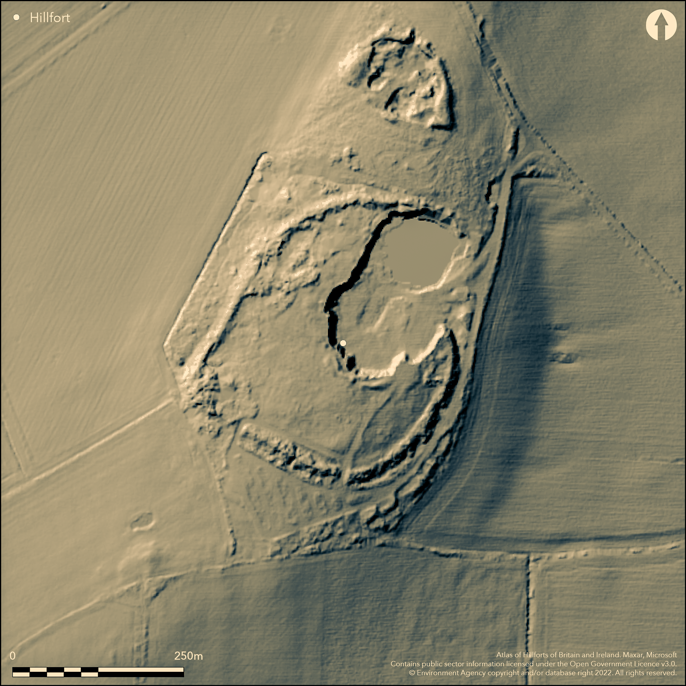
LiDAR 1m DTM Hillshade
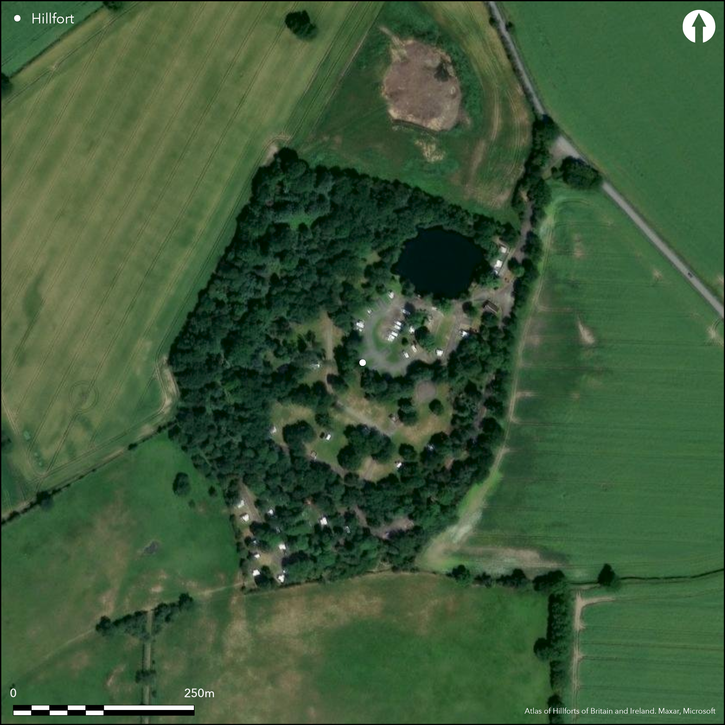
Satellite Imagery
LiDAR 1m DTM Hillshade
Satellite Imagery
Scroll left/right to view further images.
HER: Shropshire 113 (None)
NMR: SJ 51 NW 7 (70355)
SM: 1021283
NGR: SJ 546164
X: 354615 Y: 316446 (OSGB36)
Low-lying lowland hillfort on a slight knoll with the River Severn to the SW and the River Roden to the NE. Now badly affected by wartime works and now a camping and caravan site. Internal area c. 3.8ha. Excavations by Simms 1943 and Stanford 1977 and watching briefs (Hannaford 1997, 1999, 2000). Simms excavated prior to wartime construction, with a trench in SE corner and found traces of a hearth but no finds. Rescue excavations of four small trenches plus a pipe trench surveyed by Stanford in 1977 prior to caravan site developments found no structures and suggested no Roman occupation. Single bank surrounds the site, on SE and SW sides up to c. 2m with an outer ditch. No ditch can be seen on the other sides, but probably existed in prehistory as there appears to be no quarry ditch. Four gaps in ramparts, two in SW sector definitely the result of wartime road construction. Of the other two, on the NE, one may be original, or an original may have been quarried away without record. The large quarry in the NE, taking c. one third of the site of the interior, was started at least by 1841. No structures were found in the excavations, but the possible hearth and VCP (briquetage) suggests Iron Age occupation and contact to the W. Now on, and badly affected by, caravan and camping site and part wooded. On 1st Ed. OS map (1881).
Citizen Science: ✗
Reliability of Data: Confirmed
Reliability of Interpretation: Confirmed
X: -297640 Y: 6935729 (EPSG: 3857)
Longitude: -2.673746615969832 Latitude: 52.74369920822922 (EPSG:4326)
Country: England
Current County or Unitary Authority: Shropshire
Historic County: Shropshire
Current Parish/Community/Council/Townland: Uffington
Badly affected by caravan site and part wooded with WWII station. Permissive paths throughout site for campers
| Extant | ✓ |
| Cropmark | ✗ |
| Likely Destroyed | ✗ |
Camping and caravan site and part wooded.
| Woodland | ✓ |
| Commercial Forestry Plantation | ✗ |
| Parkland | ✗ |
| Pasture (Grazing) | ✓ |
| Arable | ✗ |
| Scrub/Bracken | ✗ |
| Bare Outcrop | ✗ |
| Heather/Moorland | ✗ |
| Heath | ✗ |
| Built-up | ✗ |
| Coastal Grassland | ✗ |
| Other | ✓ |
A lowland hillfort which follows the contours on a small knoll. Low-lying site on a slight knoll with the River Severn to the SW and the River Roden to the NE.
| Contour Fort | ✓ |
| Partial Contour Fort | ✗ |
| Promontory Fort | ✗ |
| Hillslope Fort | ✗ |
| Level Terrain Fort | ✗ |
| Marsh Fort | ✗ |
| Multiple Enclosure Fort | ✗ |
| Hilltop | ✗ |
| Coastal Promontory | ✗ |
| Inland Promontory | ✗ |
| Valley Bottom | ✗ |
| Knoll/Hillock/Outcrop | ✗ |
| Ridge | ✗ |
| Cliff/Plateau-edge/Scarp | ✗ |
| Hillslope | ✗ |
| Lowland | ✓ |
| Spur | ✗ |
Dominant Topographic Feature: Small lowland knoll.
| North | ✗ |
| Northeast | ✗ |
| East | ✗ |
| Southeast | ✗ |
| South | ✗ |
| Southwest | ✗ |
| West | ✗ |
| Northwest | ✗ |
| Level | ✓ |
Altitude: 92.0m
N/A
VCP (briquetage) found in Stanford's excavations suggests date of between the late Bronze Age to the Iron Age for occupation, with no evidence of Roman activity.
Reliability: C - Low
| Pre 1200BC | ✗ |
| 1200BC - 800BC | ✗ |
| 800BC - 400BC | ✓ |
| 400BC - AD50 | ✓ |
| AD50 - AD400 | ✗ |
| AD400 - AD 800 | ✗ |
| Post AD800 | ✗ |
| Unknown | ✗ |
| Pre Hillfort: | None |
| Post Hillfort: | None |
| Artefactual: | VCP (briquetage) found in Stanford's excavations. |
| Morphology/Earthwork/Typology: | Stanford suggested a date of between the late Bronze Age to the Iron Age for occupation, there being no evidence for Roman activity. |
On 1st Ed. OS map (1881). Excavations by Simms 1943 and S.C. Stanford 1977 and Watching Briefs Hannaford 1997, 1999, 2000. Air Photograph Interpretation RCHME: Marches Uplands NMP 1993-2000. Shropshire Council survey 2012.
| 1st Identified Map Depiction (1881): | OS map. |
| Excavation (1943): | Excavations by Simms. |
| Excavation (1977): | Excavations by S. Stanford. |
| Other (2012): | Shropshire Council survey. |
| Other (None): | Air Photograph Interpretation RCHME: Marches Uplands NMP 1993-2000. |
Simms found evidence of a hearth in 1943, but Stanford found no structures in 1977. Quarrying in 1934 found levelled areas quarried into the rock paved with sandstone. In 1997, two small pits were found in the interior. VCP (briquetage) sherds found by Stanford (1977) similar to those found at The Berth and the Wrekin inner camp. Also 20 seeds of, probably, corn.
Pond on site the result of quarrying.
| None | ✓ |
| Spring | ✗ |
| Stream | ✗ |
| Pool | ✗ |
| Flush | ✗ |
| Well | ✗ |
| Other | ✗ |
None
| No Known Features | ✓ |
| Round Stone Structures | ✗ |
| Rectangular Stone Structures | ✗ |
| Curvilinear Platforms | ✗ |
| Other Roundhouse Evidence | ✗ |
| Pits | ✗ |
| Quarry Hollows | ✗ |
| Other | ✗ |
Hearth found by Simms in 1943 and a possible small pit by Stanford in 1977. Quarrying in 1934 found levelled areas quarried into the rock paved with sandstone.
| No Known Excavation | ✗ |
| Pits | ✓ |
| Postholes | ✗ |
| Roundhouses | ✗ |
| Rectangular Structures | ✗ |
| Roads/Tracks | ✗ |
| Quarry Hollows | ✗ |
| Other | ✓ |
| Nothing Found | ✗ |
None
| No Known Geophysics | ✓ |
| Pits | ✗ |
| Roundhouses | ✗ |
| Rectangular Structures | ✗ |
| Roads/Tracks | ✗ |
| Quarry Hollows | ✗ |
| Other | ✗ |
| Nothing Found | ✗ |
VCP (briquetage) sherds found by Stanford (1977) similar to those found at The Berth and the Wrekin inner camp. Also 20 seeds of, probably, corn.
| No Known Finds | ✗ |
| Pottery | ✓ |
| Metal | ✗ |
| Metalworking | ✗ |
| Human Bones | ✗ |
| Animal Bones | ✗ |
| Lithics | ✗ |
| Environmental | ✓ |
| Other | ✗ |
None
| APs Not Checked | ✓ |
| None | ✗ |
| Roundhouses | ✗ |
| Rectangular Structures | ✗ |
| Pits | ✗ |
| Postholes | ✗ |
| Roads/Tracks | ✗ |
| Other | ✗ |
Entrance possibly original on the NE side side, but may have been destroyed. Two gaps on the SW certainly modern and WWII road construction.
| 4: | Two gaps on the SW certainly modern and WWII road construction. One on NE possibly modern also. |
| 2: | Possibly original on NE side, but may have been destroyed. |
Guard Chambers: ✗
Chevaux de Frise: ✗
| 1. Simple Gap (North east): | Possibly on NE side, but may have been destroyed. |
A single bank surrounds the site, on the SE and SW sides up to c. 2m with an outer ditch. No ditch can be seen on the other sides, but probably existed in prehistory as there appears to be no quarry ditch.
| Area 1: | 3.8ha. |
| Total: | 3.8ha. |
Total Footprint Area: Noneha.
None
| ✗ | None |
| ✗ | Damaged circuit. |
| NE Quadrant: | 1 |
| SE Quadrant: | 1 |
| SW Quadrant: | 1 |
| NW Quadrant: | 1 |
| Total: | 1 |
| Partial Univallate | ✗ |
| Univallate | ✓ |
| Partial Bivallate | ✗ |
| Bivallate | ✗ |
| Partial Multivallate | ✗ |
| Multivallate | ✗ |
| Unknown | ✗ |
| Partial Univallate | ✗ |
| Univallate | ✗ |
| Partial Bivallate | ✗ |
| Bivallate | ✗ |
| Partial Multivallate | ✗ |
| Multivallate | ✗ |
None
| None | ✗ |
| Earthen Bank | ✓ |
| Stone Wall | ✗ |
| Rubble | ✗ |
| Wall-walk | ✗ |
| Evidence of Timber | ✗ |
| Vitrification | ✗ |
| Other Burning | ✗ |
| Palisade | ✗ |
| Counter Scarp Bank | ✗ |
| Berm | ✗ |
| Unfinished | ✗ |
| Other | ✗ |
No details.
| None | ✓ |
| Earthen Bank | ✗ |
| Stone Wall | ✗ |
| Murus Duplex | ✗ |
| Timber-framed | ✗ |
| Timber-laced | ✗ |
| Vitrification | ✗ |
| Other Burning | ✗ |
| Palisade | ✗ |
| Counter Scarp Bank | ✗ |
| Berm | ✗ |
| Unfinished | ✗ |
| No Known Excavation | ✗ |
| Other | ✗ |
| ✗ | None |
| ✓ | An outer ditch exists on the SE and SW sides, not visible on the other sides, but probably existed in prehistory. |
Number of Ditches: 1
| ✗ | None |
Dorling, P. and Wigley, A. 2012. Assessment of the archaeological and conservation status of major later prehistoric enclosures in Herefordshire and Shropshire, EH PNUM, Version 3.2, Hereford and Shrewsbury: Herefordshire Council/Shropshire Council.
Page, W. ed. 1908. Victoria County History of Shropshire, 1, 381, Institute of Historical Research.
Stanford, S.C. 1985: Ebury Hill Camp - excavations 1977, Trans Shropshire Archaeol Hist Soc, LXIV, 9-12.
Atlas of Hillforts:
Wikidata:
This work is licensed under CC BY-SA 4.0![]()
![]()
![]() and should be cited as:
and should be cited as:
Lock, Gary and Ralston, Ian. 2024. Atlas of Hillforts of Britain and Ireland. Available at: https://hillforts.arch.ox.ac.uk
Document Version 1.1