LiDAR 1m DTM Hillshade
Satellite Imagery
LiDAR 1m DTM Hillshade
Satellite Imagery
Scroll left/right to view further images.
HER: Shropshire 180 (None)
NMR: SO 58 SE 2 (111286)
SM: 1008390
NGR: SO575847
X: 357581 Y: 284711 (OSGB36)
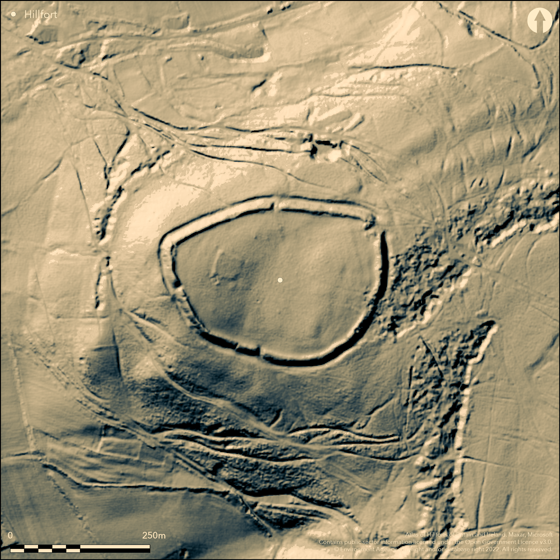
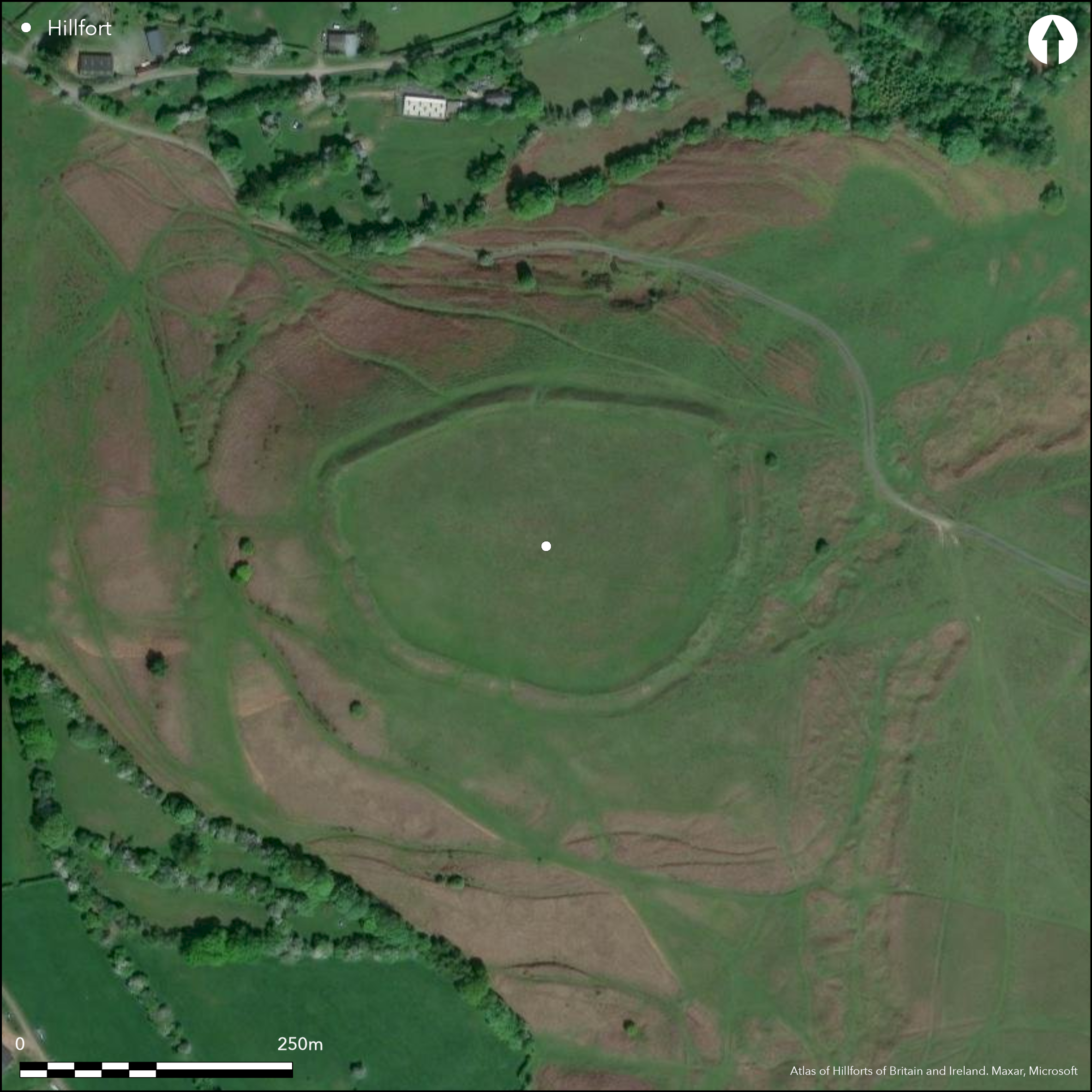
Partial contour hillfort located in a commanding position below the three hillforts (Abdon Burf - Atlas No 0039; Clee Burf - Atlas No 0064 and Titterstone Clee - Atlas No 0091), formerly on the summits of the Clees (Brown and Titterstone) that dominate SE Shropshire. Fine, high, steep and prominent it is sited on a spur top on the lower W slopes of Brown Clee Hill overlooking the valley of the River Corve. The ground falls steeply to the N, S and W. Internal area c. 2.8ha. Unlike its neighbours it is in good order. Strong defences, with single turf-covered rampart to nearly 3m on E and an outer rock-cut ditch to 1.5m in depth and between 5m-8m in width, are in evidence around the circuit. There could be traces of a counterscarp bank. The interior appears terraced and falls slightly from E to W. There is surface evidence of a square low platform with possible E entrance in the NW quadrant and a small ditched enclosure to its SW. The latter is certainly a WWII Home Guard site. There has been some quarrying and WWII disturbance - at the N end and the ditch has been disturbed around the SE quarter by the mining/quarrying encroaching onto the earthworks. There are five gaps in the ramparts, two thought to be original. The main entrance is probably at the NE corner, a widening narrow gap with causeway across the ditch and possible guard chambers. That midway along the S side, with a slight inturn, is also possibly original. Other gaps to the N, W and S are likely to be vestiges of mining/quarrying. To the N, outside the fort, are a series of hollow-ways descending the hill to the E of the entrance. One to the N predates a small quarry that cuts into it. Whilst it is tempting to suggest some prehistoric origin, it is likely that they are the result of industrial activity. Ramparts and entrances mostly well-preserved, but some sheep scrapes on the NE and S. Under pasture. Undated. On 1st Ed OS map (1885-1900).
Citizen Science: ✗
Reliability of Data: Confirmed
Reliability of Interpretation: Confirmed
X: -292295 Y: 6883486 (EPSG: 3857)
Longitude: -2.6257351216491718 Latitude: 52.45866142484317 (EPSG:4326)
Country: England
Current County or Unitary Authority: Shropshire
Historic County: Shropshire
Current Parish/Community/Council/Townland: Clee St Margaret
Ramparts and entrances mostly well-preserved, but some sheep scrapes on the NE and S. Management prescriptions sought.
| Extant | ✓ |
| Cropmark | ✗ |
| Likely Destroyed | ✗ |
Good pasture. Small ditched enclosure to its SW. The latter is certainly a WWII Home Guard site.
| Woodland | ✗ |
| Commercial Forestry Plantation | ✗ |
| Parkland | ✗ |
| Pasture (Grazing) | ✓ |
| Arable | ✗ |
| Scrub/Bracken | ✗ |
| Bare Outcrop | ✗ |
| Heather/Moorland | ✗ |
| Heath | ✗ |
| Built-up | ✗ |
| Coastal Grassland | ✗ |
| Other | ✓ |
Partial contour fort sloping slightly from E to W. Sited on a spur top on the lower W slopes of Brown Clee Hill overlooking the valley of the River Corve.
| Contour Fort | ✗ |
| Partial Contour Fort | ✓ |
| Promontory Fort | ✗ |
| Hillslope Fort | ✗ |
| Level Terrain Fort | ✗ |
| Marsh Fort | ✗ |
| Multiple Enclosure Fort | ✗ |
| Hilltop | ✗ |
| Coastal Promontory | ✗ |
| Inland Promontory | ✗ |
| Valley Bottom | ✗ |
| Knoll/Hillock/Outcrop | ✗ |
| Ridge | ✗ |
| Cliff/Plateau-edge/Scarp | ✗ |
| Hillslope | ✗ |
| Lowland | ✗ |
| Spur | ✓ |
Dominant Topographic Feature: Spur top on lower W slopes.
| North | ✗ |
| Northeast | ✗ |
| East | ✗ |
| Southeast | ✗ |
| South | ✗ |
| Southwest | ✗ |
| West | ✓ |
| Northwest | ✗ |
| Level | ✗ |
Altitude: 330.0m
N/A
None
Reliability: D - None
| Pre 1200BC | ✗ |
| 1200BC - 800BC | ✗ |
| 800BC - 400BC | ✗ |
| 400BC - AD50 | ✗ |
| AD50 - AD400 | ✗ |
| AD400 - AD 800 | ✗ |
| Post AD800 | ✗ |
| Unknown | ✓ |
| Pre Hillfort: | None |
| Post Hillfort: | Small ditched enclosure to its SW is a WWII Home Guard site. |
On 1st Ed. OS map (1885-1900). Air Photograph Interpretation RCHME: Marches Uplands NMP 1993-2000.Shropshire Council survey of 2012.
| Other (1968): | Visit by Hillfort Study Group |
| Other (2009): | Visited by Hillfort Study Group |
| Other (2012): | Shropshire Council survey. |
| 1st Identified Map Depiction (None): | 1st Ed. OS map |
| Other (None): | Air Photograph Interpretation RCHME: Marches Uplands NMP 1993-2000. |
There is surface evidence of a square low platform with possible E entrance in the NW quadrant and a small ditched enclosure to its SW. The latter is certainly a WWII Home Guard site. No evidence of hut platforms.
Clee Brook located 0.25km outside the fort.
| None | ✓ |
| Spring | ✗ |
| Stream | ✗ |
| Pool | ✗ |
| Flush | ✗ |
| Well | ✗ |
| Other | ✗ |
There is surface evidence of a square low platform with possible E entrance in the NW quadrant and a small ditched enclosure to its SW. The latter is certainly a WWII Home Guard site. No evidence of hut platforms.
| No Known Features | ✗ |
| Round Stone Structures | ✗ |
| Rectangular Stone Structures | ✗ |
| Curvilinear Platforms | ✗ |
| Other Roundhouse Evidence | ✗ |
| Pits | ✗ |
| Quarry Hollows | ✗ |
| Other | ✓ |
None
| No Known Excavation | ✓ |
| Pits | ✗ |
| Postholes | ✗ |
| Roundhouses | ✗ |
| Rectangular Structures | ✗ |
| Roads/Tracks | ✗ |
| Quarry Hollows | ✗ |
| Other | ✗ |
| Nothing Found | ✗ |
None
| No Known Geophysics | ✓ |
| Pits | ✗ |
| Roundhouses | ✗ |
| Rectangular Structures | ✗ |
| Roads/Tracks | ✗ |
| Quarry Hollows | ✗ |
| Other | ✗ |
| Nothing Found | ✗ |
None
| No Known Finds | ✓ |
| Pottery | ✗ |
| Metal | ✗ |
| Metalworking | ✗ |
| Human Bones | ✗ |
| Animal Bones | ✗ |
| Lithics | ✗ |
| Environmental | ✗ |
| Other | ✗ |
None
| APs Not Checked | ✓ |
| None | ✗ |
| Roundhouses | ✗ |
| Rectangular Structures | ✗ |
| Pits | ✗ |
| Postholes | ✗ |
| Roads/Tracks | ✗ |
| Other | ✗ |
Five gaps in the ramparts, two possibly original. Main entrance is probably at the NE corner, a widening narrow gap with causeway across the ditch and possible guard chambers. That midway along the S side, with a slight inturn, is also possibly original. Other gaps to the N, W and S are likely to be vestiges of mining/quarrying. Hollow-ways to the NE entrance are probably later and associated with mining/quarrying, but one could be possibly original.
| 5: | There are five gaps in the ramparts, two probably original. |
| 2: | Probably original entrances at the NE corner and midway along S side, both slightly inturned. Other access points probably modern associated with mining/quarrying. Possible paired guard chambers to NE entrance which has a causeway across the ditch. |
Guard Chambers: ✓
Chevaux de Frise: ✗
| 1. In-turned (North east): | Possible paired guard chambers to NE entrance which has a causeway across the ditch. |
| 1. Recesses/Guard Chambers (North east): | Possible paired guard chambers to main NE entrance. |
| 1. Hollow Way (North east): | One of the hollow ways to NE entrance could be original. |
| 2. In-turned (South): | Slightly inturned entrance midway along the S side. |
Strong defences, with single turf-covered rampart to nearly 3m on the E and an outer rock-cut ditch to 1.5m in depth and between 5m-8m in width, are in evidence around the circuit. There could be traces of a counterscarp bank.
| Area 1: | 2.8ha. |
| Total: | 2.8ha. |
Total Footprint Area: Noneha.
None
| ✗ | The boundary of the site is easily discernible over the complete circuit. |
| ✓ | Good evidence around the complete circuit. |
| NE Quadrant: | 1 |
| SE Quadrant: | 1 |
| SW Quadrant: | 1 |
| NW Quadrant: | 1 |
| Total: | 1 |
| Partial Univallate | ✗ |
| Univallate | ✓ |
| Partial Bivallate | ✗ |
| Bivallate | ✗ |
| Partial Multivallate | ✗ |
| Multivallate | ✗ |
| Unknown | ✗ |
| Partial Univallate | ✗ |
| Univallate | ✗ |
| Partial Bivallate | ✗ |
| Bivallate | ✗ |
| Partial Multivallate | ✗ |
| Multivallate | ✗ |
Strong defences, with single turf-covered rampart. There could be traces of a counterscarp bank.
| None | ✗ |
| Earthen Bank | ✓ |
| Stone Wall | ✗ |
| Rubble | ✗ |
| Wall-walk | ✗ |
| Evidence of Timber | ✗ |
| Vitrification | ✗ |
| Other Burning | ✗ |
| Palisade | ✗ |
| Counter Scarp Bank | ✓ |
| Berm | ✗ |
| Unfinished | ✗ |
| Other | ✗ |
None
| None | ✗ |
| Earthen Bank | ✗ |
| Stone Wall | ✗ |
| Murus Duplex | ✗ |
| Timber-framed | ✗ |
| Timber-laced | ✗ |
| Vitrification | ✗ |
| Other Burning | ✗ |
| Palisade | ✗ |
| Counter Scarp Bank | ✗ |
| Berm | ✗ |
| Unfinished | ✗ |
| No Known Excavation | ✓ |
| Other | ✗ |
| ✗ | None |
| ✓ | An outer rock-cut ditch to 1.5m in depth and between 5m-8m in width, is in evidence around the circuit. |
Number of Ditches: 1
| ✗ | None |
Dorling, P. and Wigley, A. 2012. Assessment of the archaeological and conservation status of major later prehistoric enclosures in Herefordshire and Shropshire, EH PNUM, Version 3.2, Hereford and Shrewsbury: Herefordshire Council/Shropshire Council.
Page, W. ed. 1908. Victoria County History of Shropshire, 1, 371, Institute of Historical Research.
Atlas of Hillforts:
Wikidata:
This work is licensed under CC BY-SA 4.0![]()
![]()
![]() and should be cited as:
and should be cited as:
Lock, Gary and Ralston, Ian. 2024. Atlas of Hillforts of Britain and Ireland. Available at: https://hillforts.arch.ox.ac.uk
Document Version 1.1