LiDAR 1m DTM Hillshade
Satellite Imagery
LiDAR 1m DTM Hillshade
Satellite Imagery
Scroll left/right to view further images.
HER: Shropshire 158 (None)
NMR: SO 48 SW 13 (109058)
SM: 1021073
NGR: SO447820
X: 344754 Y: 281945 (OSGB36)
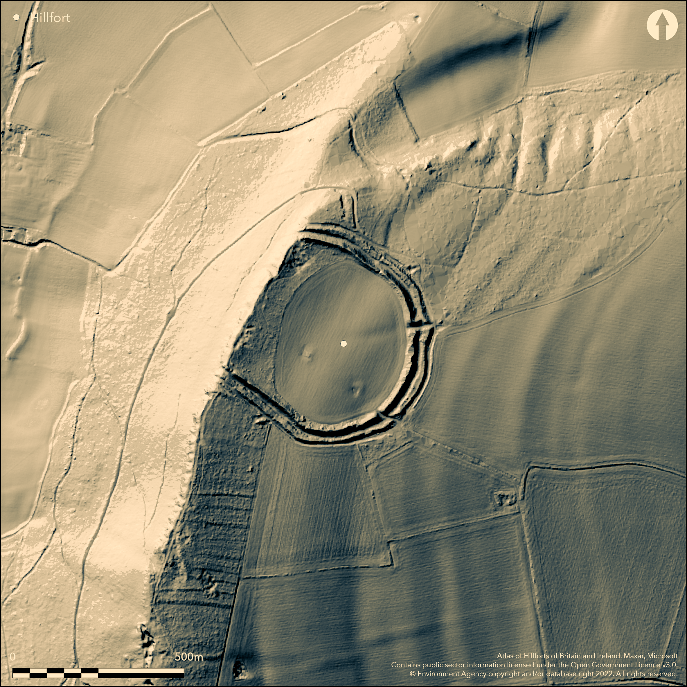
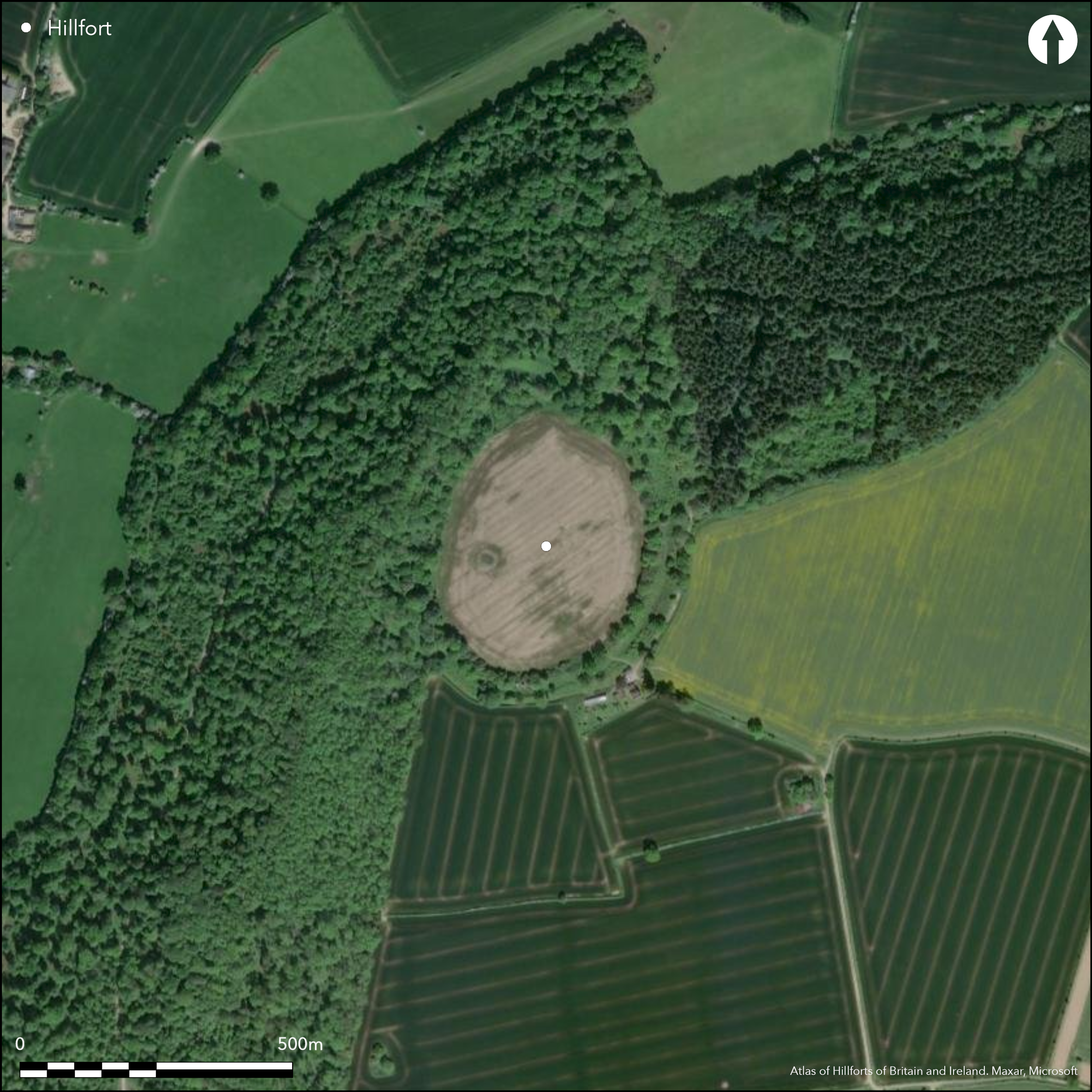
Large and very prominent D-shaped hillfort on steep wooded slopes above the River Onny at Craven Arms. slopes are precipitous to the NW. Internal area c. 6.6ha. There are two ramparts with external ditch, except on the precipitous NW side where there is a single small bank or straight side rampart with evidence of breastwork or low wall on its top. The inner rampart is steep sided with a narrow top, the outer gentler and stepped in places. To the SW the site is reinforced by two additional banks separated by a ditch, which could be late Bronze Age cross-dykes incorporated into the circuit. Rock-cut faces are visible in the medial ditch at the SW and NE ends of the site. There are two elaborate entrances, to the E and SE. There is a possible spring located 50m from the SE entrance as an oval depression. The interior is under intensive arable cultivation and ramparts tree covered with major scrub, including laurel, problems. This has encouraged burrowing animals which are causing major erosion. A Keeper's Cottage abuts the SE corner of the site and tracks and general farming litter disfigure the interior which is deteriorating in condition. Minimal investigations. Undated. On 1st Ed OS map (1885-1900).
Citizen Science: ✗
Reliability of Data: Confirmed
Reliability of Interpretation: Confirmed
X: -313257 Y: 6878735 (EPSG: 3857)
Longitude: -2.8140378910080948 Latitude: 52.43264788603951 (EPSG:4326)
Country: England
Current County or Unitary Authority: Shropshire
Historic County: Shropshire
Current Parish/Community/Council/Townland: Culmington
Interior under intensive arable cultivation and ramparts tree covered with major scrub, including laurel, problems. This has encouraged burrowing animals which are causing major erosion problems. The site is deteriorating in condition. Small stone quarries in the NW sector. On Heritage at Risk Register (2015).
| Extant | ✓ |
| Cropmark | ✗ |
| Likely Destroyed | ✗ |
Ramparts tree covered with dense scrub, including laurel, and interior cultivated.
| Woodland | ✓ |
| Commercial Forestry Plantation | ✗ |
| Parkland | ✗ |
| Pasture (Grazing) | ✗ |
| Arable | ✓ |
| Scrub/Bracken | ✓ |
| Bare Outcrop | ✗ |
| Heather/Moorland | ✗ |
| Heath | ✗ |
| Built-up | ✗ |
| Coastal Grassland | ✗ |
| Other | ✗ |
Partial contour fort with gentle E-facing slopes and summit of hill located above the River Onny.
| Contour Fort | ✗ |
| Partial Contour Fort | ✓ |
| Promontory Fort | ✗ |
| Hillslope Fort | ✗ |
| Level Terrain Fort | ✗ |
| Marsh Fort | ✗ |
| Multiple Enclosure Fort | ✗ |
| Hilltop | ✓ |
| Coastal Promontory | ✗ |
| Inland Promontory | ✗ |
| Valley Bottom | ✗ |
| Knoll/Hillock/Outcrop | ✗ |
| Ridge | ✗ |
| Cliff/Plateau-edge/Scarp | ✗ |
| Hillslope | ✗ |
| Lowland | ✗ |
| Spur | ✗ |
Dominant Topographic Feature: Hill top.
| North | ✗ |
| Northeast | ✗ |
| East | ✓ |
| Southeast | ✗ |
| South | ✗ |
| Southwest | ✗ |
| West | ✗ |
| Northwest | ✗ |
| Level | ✓ |
Altitude: 294.0m
N/A
None
Reliability: D - None
| Pre 1200BC | ✗ |
| 1200BC - 800BC | ✗ |
| 800BC - 400BC | ✗ |
| 400BC - AD50 | ✗ |
| AD50 - AD400 | ✗ |
| AD400 - AD 800 | ✗ |
| Post AD800 | ✗ |
| Unknown | ✓ |
| Pre Hillfort: | None |
| Post Hillfort: | None |
On 1st Ed OS map (1885-1900). Air Photograph Interpretation RCHME: Marches Uplands NMP 1993-2000.Shropshire Council survey 2012.
| Other (2012): | Shropshire Council survey. |
| 1st Identified Map Depiction (None): | 1st Ed OS |
| Other (None): | Air Photograph Interpretation RCHME: Marches Uplands NMP. |
Small stone quarries in the NW sector (modern?).
River Onny is located 0.7km. from the fort. There is a possible spring located 50m from the SE entrance as an oval depression.
| None | ✗ |
| Spring | ✓ |
| Stream | ✗ |
| Pool | ✗ |
| Flush | ✗ |
| Well | ✗ |
| Other | ✗ |
Small stone quarries in the NW sector, probably modern.
| No Known Features | ✗ |
| Round Stone Structures | ✗ |
| Rectangular Stone Structures | ✗ |
| Curvilinear Platforms | ✗ |
| Other Roundhouse Evidence | ✗ |
| Pits | ✗ |
| Quarry Hollows | ✗ |
| Other | ✓ |
None
| No Known Excavation | ✓ |
| Pits | ✗ |
| Postholes | ✗ |
| Roundhouses | ✗ |
| Rectangular Structures | ✗ |
| Roads/Tracks | ✗ |
| Quarry Hollows | ✗ |
| Other | ✗ |
| Nothing Found | ✗ |
None
| No Known Geophysics | ✓ |
| Pits | ✗ |
| Roundhouses | ✗ |
| Rectangular Structures | ✗ |
| Roads/Tracks | ✗ |
| Quarry Hollows | ✗ |
| Other | ✗ |
| Nothing Found | ✗ |
None
| No Known Finds | ✓ |
| Pottery | ✗ |
| Metal | ✗ |
| Metalworking | ✗ |
| Human Bones | ✗ |
| Animal Bones | ✗ |
| Lithics | ✗ |
| Environmental | ✗ |
| Other | ✗ |
None
| APs Not Checked | ✓ |
| None | ✗ |
| Roundhouses | ✗ |
| Rectangular Structures | ✗ |
| Pits | ✗ |
| Postholes | ✗ |
| Roads/Tracks | ✗ |
| Other | ✗ |
There are two elaborate entrances with in and out-turns, to the E and SE. Break in rampart for farm access to NW.
| 3: | Break in rampart for farm access to NW. |
| 2: | Two elaborate entrances with inturns and out-turns. |
Guard Chambers: ✗
Chevaux de Frise: ✗
| 1. In-turned (East): | Elaborate entrance. |
| 1. Out-turned (East): | None |
| 2. In-turned (South east): | Elaborate entance. |
| 2. Out-turned (South east): | None |
There are two ramparts with external ditch, except on the precipitous NW side where there is a single small bank or straight side rampart with evidence of breastwork or low wall on its top. The inner rampart is steep sided with a narrow top, the outer gentler and stepped in places. To the SW the site is reinforced by two additional banks separated by a ditch, which could be late Bronze Age cross-dykes incorporated into the circuit. Rock-cut faces are visible in the medial ditch at the SW and NE ends of the site. Up to three ditches.
| Area 1: | 6.6ha. |
| Total: | 6.6ha. |
Total Footprint Area: Noneha.
None
| ✗ | None |
| ✗ | The number of banks vary about the site. |
| NE Quadrant: | 2 |
| SE Quadrant: | 2 |
| SW Quadrant: | 4 |
| NW Quadrant: | 1 |
| Total: | 4 |
| Partial Univallate | ✓ |
| Univallate | ✗ |
| Partial Bivallate | ✓ |
| Bivallate | ✗ |
| Partial Multivallate | ✓ |
| Multivallate | ✗ |
| Unknown | ✗ |
| Partial Univallate | ✗ |
| Univallate | ✗ |
| Partial Bivallate | ✗ |
| Bivallate | ✗ |
| Partial Multivallate | ✗ |
| Multivallate | ✗ |
Evidence of breastwork or low wall on top of small rampart on NW.
| None | ✗ |
| Earthen Bank | ✓ |
| Stone Wall | ✗ |
| Rubble | ✗ |
| Wall-walk | ✗ |
| Evidence of Timber | ✗ |
| Vitrification | ✗ |
| Other Burning | ✗ |
| Palisade | ✗ |
| Counter Scarp Bank | ✗ |
| Berm | ✗ |
| Unfinished | ✗ |
| Other | ✓ |
None
| None | ✗ |
| Earthen Bank | ✗ |
| Stone Wall | ✗ |
| Murus Duplex | ✗ |
| Timber-framed | ✗ |
| Timber-laced | ✗ |
| Vitrification | ✗ |
| Other Burning | ✗ |
| Palisade | ✗ |
| Counter Scarp Bank | ✗ |
| Berm | ✗ |
| Unfinished | ✗ |
| No Known Excavation | ✓ |
| Other | ✗ |
| ✗ | None |
| ✓ | Up to three ditches. Rock-cut faces are visible in the medial ditch at the SW and NE ends of the site. |
Number of Ditches: 3
| ✗ | None |
Dorling, P. and Wigley, A. 2012. Assessment of the archaeological and conservation status of major later prehistoric enclosures in Herefordshire and Shropshire, EH PNUM, Version 3.2, Hereford and Shrewsbury: Herefordshire Council/Shropshire Council.
Page, W. ed. 1908. Victoria County History of Shropshire, 1, 373-74, Institute of Historical Research.
Atlas of Hillforts:
Wikidata:
This work is licensed under CC BY-SA 4.0![]()
![]()
![]() and should be cited as:
and should be cited as:
Lock, Gary and Ralston, Ian. 2024. Atlas of Hillforts of Britain and Ireland. Available at: https://hillforts.arch.ox.ac.uk
Document Version 1.1