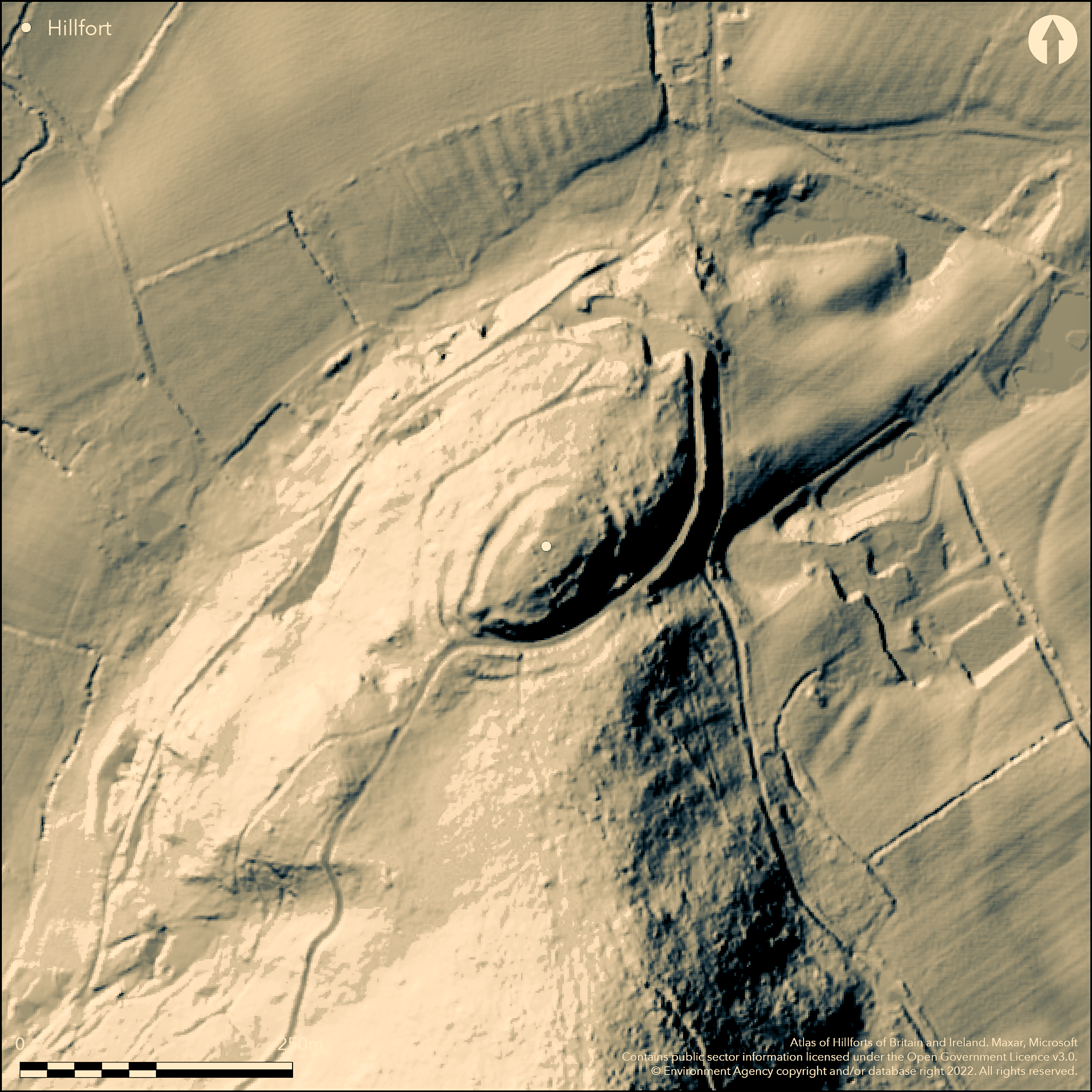
LiDAR 1m DTM Hillshade

Satellite Imagery
LiDAR 1m DTM Hillshade
Satellite Imagery
Scroll left/right to view further images.
HER: Shropshire 1055 (None)
NMR: SJ 40 NW 4 (67697)
SM: 1019829
NGR: SJ 408055
X: 340869 Y: 305575 (OSGB36)
Interesting and complicated fort, despite forestry damage, located on col on the lower NE-facing spur slopes of Pontesford Hill below Earl's Hill hillfort (Atlas No 0066). Suggested as a satellite of the latter, but no evidence for this apart from location. Feature is the massive defence surrounding a small interior of c. 0.28ha.The ramparts appear to be of dump construction of yellow boulder clay of inner rampart up to 2m high, traces of a medial ditch, 7m wide and to 0.3m deep on the W and NE sides, and an outer rampart, up to 4.5m high, and outer ditch. The E to S side has been mostly destroyed by a forestry road. On the weaker W side, is a third outer rampart, 9m wide, and up to 2m high externally, with the inner ditch 6m wide and up to 0.3m deep. A rock outcrop on the NW coincides with the outer rampart. Both rampart and ditch terminate at the original SW entrance, with gap 3.5m wide and marked by the inturning for 10m of the inner rampart scarp to form passageway. Outworks, defined by Cobbold in 1907, cannot be traced. An emergency excavation by P. Barker in 1963, as a result of forestry track operations, focussed on the S defences to the E of the entrance. Three pre-rampart phases were found in a trench through the middle rampart, finding traces of a palisade and flints and pebble surfaces associated with post-built structures and rubbish pit with charcoal of Neolithic date. Young trees, scrub and bracken dominate the site. SSSI. On 1st Ed OS map (1885-1900).
Citizen Science: ✗
Reliability of Data: Confirmed
Reliability of Interpretation: Confirmed
X: -320087 Y: 6917537 (EPSG: 3857)
Longitude: -2.875389263991697 Latitude: 52.64465106395058 (EPSG:4326)
Country: England
Current County or Unitary Authority: Shropshire
Historic County: Shropshire
Current Parish/Community/Council/Townland: Pontesbury
Part-wooded. Forestry Commission access road cuts along main ditch slicing off the front edge of the counterscarp of the outer rampart. Paths and boundary bank confuse matters. Some visitor erosion as open access.
| Extant | ✓ |
| Cropmark | ✗ |
| Likely Destroyed | ✓ |
Young trees, scrub and bracken dominate the site. Substantial forestry road. SSSI.
| Woodland | ✓ |
| Commercial Forestry Plantation | ✗ |
| Parkland | ✗ |
| Pasture (Grazing) | ✗ |
| Arable | ✗ |
| Scrub/Bracken | ✓ |
| Bare Outcrop | ✗ |
| Heather/Moorland | ✗ |
| Heath | ✗ |
| Built-up | ✗ |
| Coastal Grassland | ✗ |
| Other | ✓ |
Site slightly slopes to the NE, partially following the contours. Located on a col on the lower NE facing spur slopes of Pontesford Hill below Earl's Hill hillfort.
| Contour Fort | ✗ |
| Partial Contour Fort | ✓ |
| Promontory Fort | ✗ |
| Hillslope Fort | ✗ |
| Level Terrain Fort | ✗ |
| Marsh Fort | ✗ |
| Multiple Enclosure Fort | ✗ |
| Hilltop | ✗ |
| Coastal Promontory | ✗ |
| Inland Promontory | ✗ |
| Valley Bottom | ✗ |
| Knoll/Hillock/Outcrop | ✗ |
| Ridge | ✗ |
| Cliff/Plateau-edge/Scarp | ✗ |
| Hillslope | ✗ |
| Lowland | ✗ |
| Spur | ✓ |
Dominant Topographic Feature: NE-facing spur.
| North | ✗ |
| Northeast | ✓ |
| East | ✗ |
| Southeast | ✗ |
| South | ✗ |
| Southwest | ✗ |
| West | ✗ |
| Northwest | ✗ |
| Level | ✗ |
Altitude: 185.0m
N/A
Possible Neolithic occupation of the col as flints found. Rampart possibly late Iron Age.
Reliability: C - Low
| Pre 1200BC | ✗ |
| 1200BC - 800BC | ✗ |
| 800BC - 400BC | ✗ |
| 400BC - AD50 | ✓ |
| AD50 - AD400 | ✗ |
| AD400 - AD 800 | ✗ |
| Post AD800 | ✗ |
| Unknown | ✗ |
| Pre Hillfort: | None |
| Post Hillfort: | None |
| Artefactual: | Possible Neolithic occupation of the col as flints found. Rampart possibly late iron Age. |
| Morphology/Earthwork/Typology: | Rampart possibly late Iron Age. |
On 1st Ed OS map (1885-1900). Excavation by Barker in 1963 as a result of forestry track operations. Air Photograph Interpretation RCHME: Marches Uplands NMP 1993-2000. Shropshire Council survey 2012.
| Excavation (1963): | Emergency excavation by P. Barker |
| Other (2009): | Visited by Hillfort Study Group |
| Other (2012): | Shropshire Council survey. |
| 1st Identified Map Depiction (None): | 1st Ed OS |
| Other (None): | Air Photograph Interpretation RCHME: Marches Uplands NMP. |
The excavation concentrated on the S defences near to the E of the SW entrance with no interior excavation, as a result there are no indications, as yet, of interior settlement.
Stream located 0.5km outside the fort.
| None | ✓ |
| Spring | ✗ |
| Stream | ✗ |
| Pool | ✗ |
| Flush | ✗ |
| Well | ✗ |
| Other | ✗ |
None
| No Known Features | ✓ |
| Round Stone Structures | ✗ |
| Rectangular Stone Structures | ✗ |
| Curvilinear Platforms | ✗ |
| Other Roundhouse Evidence | ✗ |
| Pits | ✗ |
| Quarry Hollows | ✗ |
| Other | ✗ |
The excavation concentrated on the S defences near to the E of the SW entrance with no interior excavation.
| No Known Excavation | ✓ |
| Pits | ✗ |
| Postholes | ✗ |
| Roundhouses | ✗ |
| Rectangular Structures | ✗ |
| Roads/Tracks | ✗ |
| Quarry Hollows | ✗ |
| Other | ✗ |
| Nothing Found | ✗ |
None
| No Known Geophysics | ✓ |
| Pits | ✗ |
| Roundhouses | ✗ |
| Rectangular Structures | ✗ |
| Roads/Tracks | ✗ |
| Quarry Hollows | ✗ |
| Other | ✗ |
| Nothing Found | ✗ |
The excavation concentrated on the S defences near to the E of the SW entrance with no interior excavation, finding flint implements, including a Neolithic scraper of Windmill Hill type, charcoal, rubbish pit and pig's tooth.
| No Known Finds | ✗ |
| Pottery | ✗ |
| Metal | ✗ |
| Metalworking | ✗ |
| Human Bones | ✗ |
| Animal Bones | ✓ |
| Lithics | ✓ |
| Environmental | ✗ |
| Other | ✓ |
None
| APs Not Checked | ✓ |
| None | ✗ |
| Roundhouses | ✗ |
| Rectangular Structures | ✗ |
| Pits | ✗ |
| Postholes | ✗ |
| Roads/Tracks | ✗ |
| Other | ✗ |
Both rampart and ditch terminate at the original SW entrance, with gap 3.5m wide and marked by the inturning for 10m of the inner rampart scarp to form passageway.
| 1: | No modern gaps visible. |
| 2: | Existing SW entrance into the interior probably original. |
Guard Chambers: ✗
Chevaux de Frise: ✗
| 1. In-turned (South west): | Both rampart and ditch terminate at the original SW entrance, with gap 3.5m wide and marked by the inturning for 10m of the inner rampart scarp to form passageway. |
| 1. Passage-way/Corridor (South west): | None |
The ramparts appear to be of dump construction of yellow boulder clay of inner rampart up to 2m high, traces of a medial ditch, 7m wide and to 0.3m deep on the W and NE sides, and an outer rampart, up to 4.5m high, and outer ditch. The E to S side has been mostly destroyed by a forestry road. On the weaker W side, is a third outer rampart, 9m wide, and up to 2m high externally, with the inner ditch 6m wide and up to 0.3m deep. A rock outcrop on the NW coincides with the outer rampart.
| Area 1: | 0.28ha. |
| Total: | 0.28ha. |
Total Footprint Area: Noneha.
E to S defences destroyed by a forestry road.
| ✓ | There is a marked contrast between the size of the whole site footprint and the interior area. Three pre-rampart phases were found in a trench through the middle rampart. |
| ✗ | E to S defences destroyed by a forestry road. |
| NE Quadrant: | 0 |
| SE Quadrant: | 0 |
| SW Quadrant: | 3 |
| NW Quadrant: | 3 |
| Total: | 3 |
| Partial Univallate | ✗ |
| Univallate | ✗ |
| Partial Bivallate | ✗ |
| Bivallate | ✗ |
| Partial Multivallate | ✓ |
| Multivallate | ✗ |
| Unknown | ✗ |
| Partial Univallate | ✗ |
| Univallate | ✓ |
| Partial Bivallate | ✗ |
| Bivallate | ✗ |
| Partial Multivallate | ✗ |
| Multivallate | ✗ |
None
| None | ✗ |
| Earthen Bank | ✓ |
| Stone Wall | ✗ |
| Rubble | ✗ |
| Wall-walk | ✗ |
| Evidence of Timber | ✗ |
| Vitrification | ✗ |
| Other Burning | ✗ |
| Palisade | ✗ |
| Counter Scarp Bank | ✗ |
| Berm | ✗ |
| Unfinished | ✗ |
| Other | ✗ |
Rampart of dump construction. Earlier Neolithic palisade found by excavation with widely-spaced postholes and pebble surfaces associated with post-built structures beneath the middle rampart and Neolithic rubbish pit.
| None | ✗ |
| Earthen Bank | ✓ |
| Stone Wall | ✗ |
| Murus Duplex | ✗ |
| Timber-framed | ✗ |
| Timber-laced | ✗ |
| Vitrification | ✗ |
| Other Burning | ✗ |
| Palisade | ✓ |
| Counter Scarp Bank | ✗ |
| Berm | ✗ |
| Unfinished | ✗ |
| No Known Excavation | ✗ |
| Other | ✓ |
| ✗ | None |
| ✓ | Two ditches rising to three in W. E ditches destroyed and ditches generally buried features. Medial ditch between inner and outer rampart is buried and has been mistaken for a berm. |
Number of Ditches: 3
| ✗ | None |
Barker, P. 1972. The emergency excavation at Pontesford Hill Camp 1963. In Lynch, F. and Burgess, C. (eds.) Prehistoric man in Wales and the west, 345-53, plan, Bath: Adams and Dart.
Dorling, P. and Wigley, A. 2012. Assessment of the archaeological and conservation status of major later prehistoric enclosures in Herefordshire and Shropshire, EH PNUM, Version 3.2, Hereford and Shrewsbury: Herefordshire Council/Shropshire Council.
Atlas of Hillforts:
Wikidata:
This work is licensed under CC BY-SA 4.0![]()
![]()
![]() and should be cited as:
and should be cited as:
Lock, Gary and Ralston, Ian. 2024. Atlas of Hillforts of Britain and Ireland. Available at: https://hillforts.arch.ox.ac.uk
Document Version 1.1