LiDAR 1m DTM Hillshade
Satellite Imagery
LiDAR 1m DTM Hillshade
Satellite Imagery
Scroll left/right to view further images.
HER: Shropshire 129 (None)
NMR: SJ 42 SW 1 (68578)
SM: 1004770
NGR: SJ 430236
X: 343022 Y: 323686 (OSGB36)
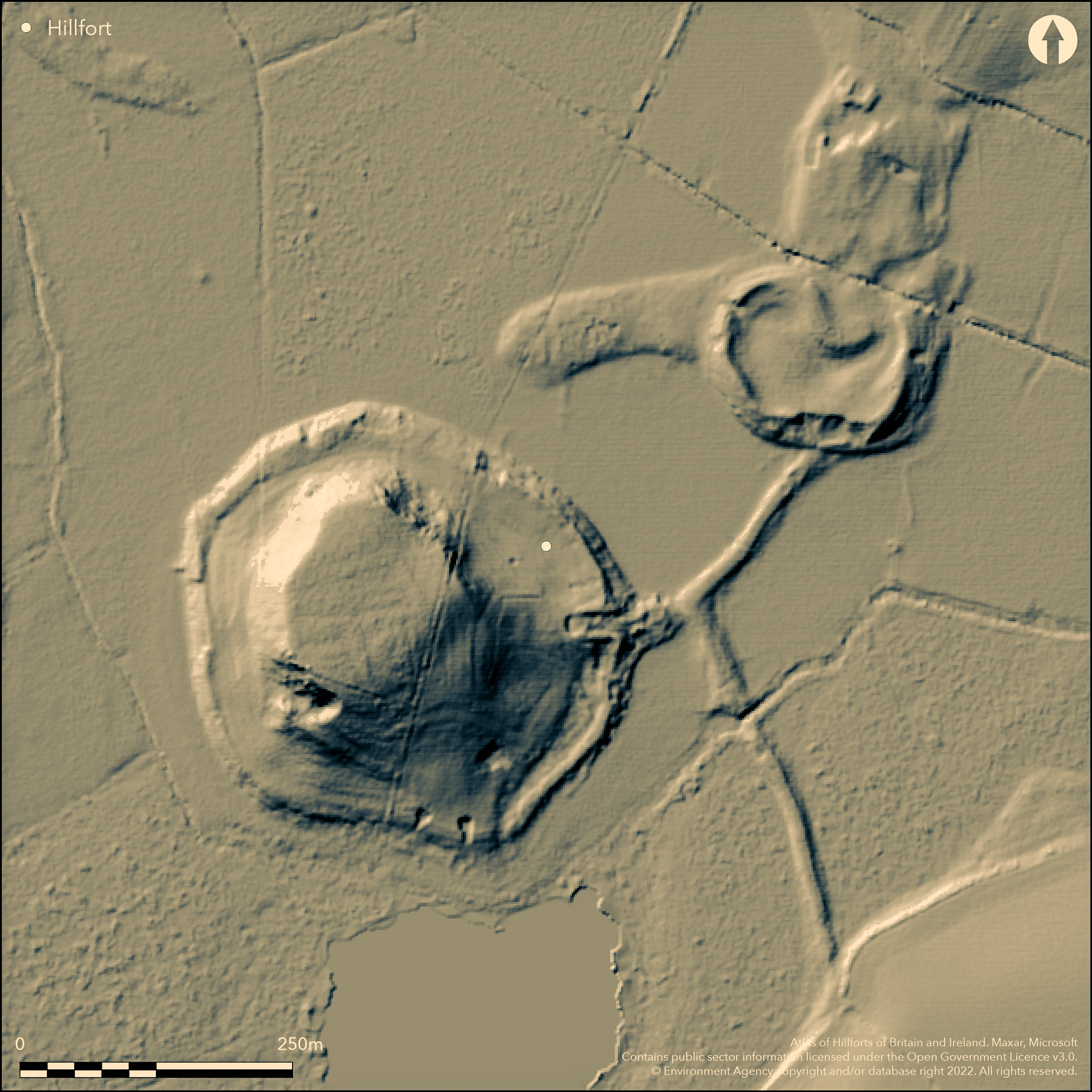
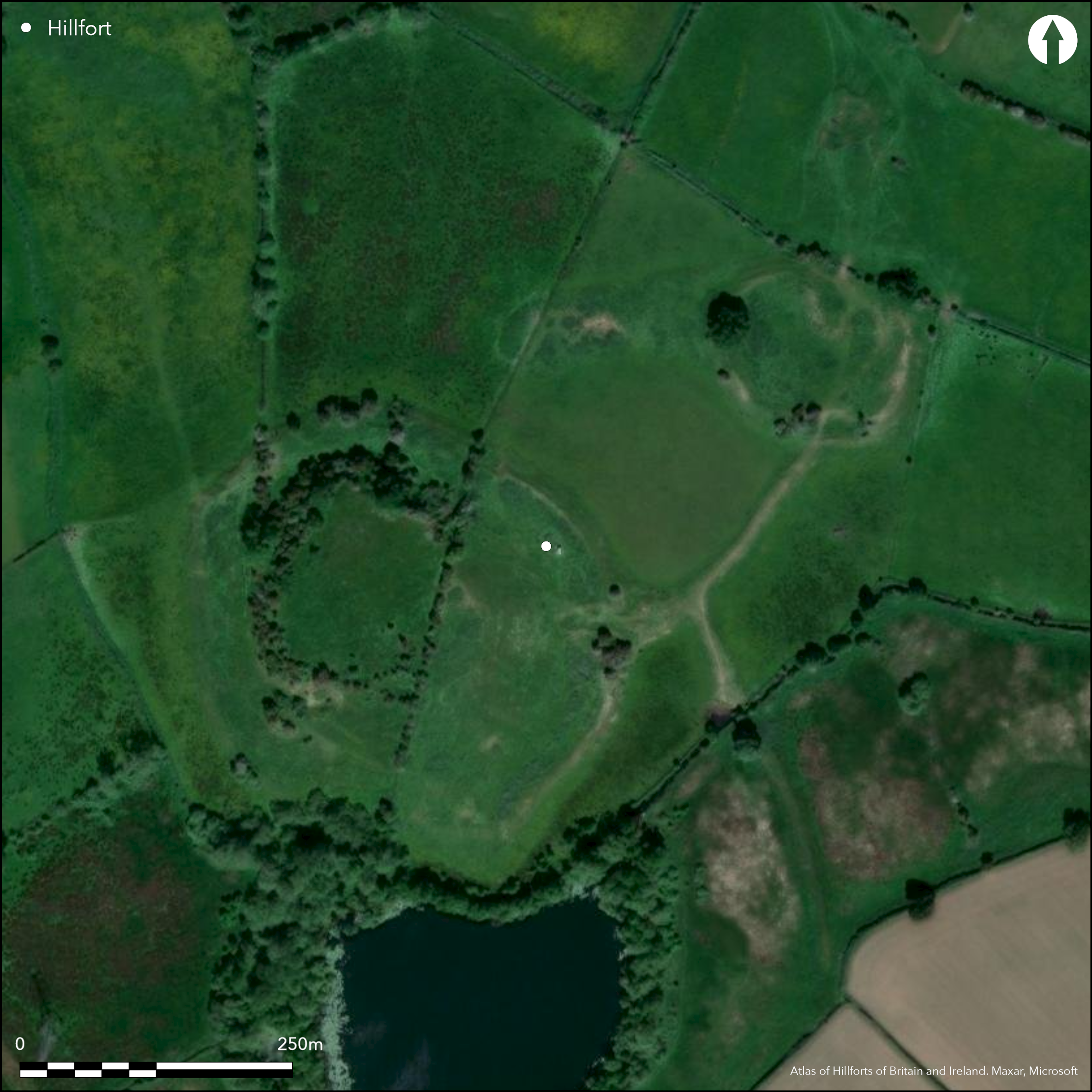
Isolated and important marsh fort located on two glacial gravel mounds and comprising two connected enclosures, formerly surrounded by wetland, lake and fen near to the River Perry and overlooking The Berth Pool. The larger mound, 220m by 250m, at only 92m O.D., is surrounded by a single irregular circuit of scarp cut on the N, W and S sides and bank on the E, possibly two banks in places, and enclosing some 3.1ha, with two possible entrances. To the N, the smaller mound, at 130m by 100m, also has a single rampart on the S, W and E sides, enclosing c. 0.5ha. Both of these enclosures are connected by a gravel, stone, possibly revettted, causeway 120m in length, which is also linked with the rising ground to the S by another causeway some 240m in length (excavation has shown this to be medieval, Shelagh Norton pers. com). This is now cut through by a stream which drains The Berth Pool, and this is where a Roman bronze cauldron was found some time before 1906. The inturned entrance to the main enclosure has been mutilated by 19th century gravel digging as is the ground within the interior to the S of this entrance. There are two entrances to the smaller enclosure, that to the SW also mutilated, with damage also to the rampart from a tractor route which crosses the ramparts. Trial excavations of the large enclosure by P.S. Gelling between 1962-63 showed the rampart to be of slight construction of stone and gravel and at some stage widened without any major increase in height. As a possible protection from lake waters, a rough facing of relatively large stones had been inserted to the lower outside of the rampart. Three main levels of occupation, interspaced with sterile layers, were detected. Finds included Iron Age VCP in all layers (rare in the lowest), with other mid to late Iron Age pottery sherds from the upper levels, metalware and a La Tene brooch, and later a Romano-British glass bead was found. Timber buildings of Iron Age and Roman date were also found. It appears that the site was, therefore, in use from the late Iron Age through to the late Roman 4th century period and possibly beyond. Under, generally wet, unimproved pasture, with some scrub on NE and NW slopes. Despite being farmed, in good condition. A third mound, adjacent to the smaller one, has no artificial defences visible. On 1st Ed OS map (1885-1900).
Citizen Science: ✗
Reliability of Data: Confirmed
Reliability of Interpretation: Confirmed
X: -316895 Y: 6947502 (EPSG: 3857)
Longitude: -2.8467198452110427 Latitude: 52.80767780188597 (EPSG:4326)
Country: England
Current County or Unitary Authority: Shropshire
Historic County: Shropshire
Current Parish/Community/Council/Townland: Baschurch
The site is farmed and generally in good condition, although a tractor track crosses the ramparts in the large enclosure, early quarrying has taken place in the smaller and the entrances have been mutilated.
| Extant | ✓ |
| Cropmark | ✗ |
| Likely Destroyed | ✗ |
Unimproved, poorly drained, pasture with scrub on the NW and NE slopes. Early quarrying.
| Woodland | ✗ |
| Commercial Forestry Plantation | ✗ |
| Parkland | ✗ |
| Pasture (Grazing) | ✓ |
| Arable | ✗ |
| Scrub/Bracken | ✓ |
| Bare Outcrop | ✗ |
| Heather/Moorland | ✗ |
| Heath | ✗ |
| Built-up | ✗ |
| Coastal Grassland | ✗ |
| Other | ✓ |
Definite and unique marsh fort, in being located on two glacial mounds. Isolated marsh fort, comprising two enclosures located on gravel glacial mounds, formerly surrounded by wetland and fen near to the River Perry and located near to the present Berth Pool.
| Contour Fort | ✗ |
| Partial Contour Fort | ✗ |
| Promontory Fort | ✗ |
| Hillslope Fort | ✗ |
| Level Terrain Fort | ✗ |
| Marsh Fort | ✓ |
| Multiple Enclosure Fort | ✗ |
| Hilltop | ✗ |
| Coastal Promontory | ✗ |
| Inland Promontory | ✗ |
| Valley Bottom | ✗ |
| Knoll/Hillock/Outcrop | ✗ |
| Ridge | ✗ |
| Cliff/Plateau-edge/Scarp | ✗ |
| Hillslope | ✗ |
| Lowland | ✓ |
| Spur | ✗ |
Dominant Topographic Feature: Three glacial mounds, two enclosed.
| North | ✗ |
| Northeast | ✗ |
| East | ✗ |
| Southeast | ✗ |
| South | ✗ |
| Southwest | ✗ |
| West | ✗ |
| Northwest | ✗ |
| Level | ✓ |
Altitude: 95.0m
N/A
Middle to late Iron Age to Roman pottery found. Bronze, sub-Roman to Roman cauldron found in 1906 with evidence of Roman timber building of c. 4th century AD.
Reliability: B - Medium
| Pre 1200BC | ✗ |
| 1200BC - 800BC | ✗ |
| 800BC - 400BC | ✗ |
| 400BC - AD50 | ✓ |
| AD50 - AD400 | ✓ |
| AD400 - AD 800 | ✓ |
| Post AD800 | ✗ |
| Unknown | ✗ |
| Pre Hillfort: | None |
| Post Hillfort: | None |
| Artefactual: | Middle to late Iron Age to Roman pottery found. Bronze, sub Roman to Roman cauldron found in 1906 with evidence of Roman timber building of c. 4th century AD. |
On 1st Ed OS map (1885-1900). Trial excavations of larger enclosure by P.S. Gelling in 1962-3. Field observation Shropshire CC 1981. Field observations English Heritage 1978, 1982. Geophysical survey GSB Prospection 1994. Air Photograph Interpretation RCHME: Marches Uplands NMP 1993-2000. Shropshire Council survey 2012.
| Other (1977): | Visit by Hillfort Study Group |
| Other (1981): | Field observation Shropshire CC. |
| Other (1994): | Geophysical survey GSB Prospection. |
| Other (2012): | Shropshire Council survey. |
| 1st Identified Map Depiction (None): | 1st Ed OS |
| Excavation (None): | Excavation by P.S. Gelling. |
| Other (None): | Field observations EH. |
| Other (None): | Air Photograph Interpretation RCHME: Marches Uplands NMP. |
Two platforms have been cut into the slope on the N side of the larger enclosure and may be of late date. In the smaller enclosure are two platforms cut into the rampart on the S and there is evidence of quarrying here, possibly of ancient date. Gelling found evidence of two timber buildings on the same level NW of the main entrance, one of Iron Age and the other of 4th. century AD date. VCP pottery was found in all layers by Gelling, with mid to late Iron Age and Roman ware in the upper layers. This included a sherd of 'duck stamped' ware, typical of the Welsh Marches, and sherds of linear and scored ware and several Roman sherds. VCP made up three-quarters of the pottery found. Metalware included iron knives and a La Tene brooch. Earlier, before 1906, a bronze cauldron of sub-Roman to Roman date, had been found and a Romano-British glass bead was found in 1976.
It is possible that the causeways could have been used to retain water. The site was surrounded by adequate water sources of fen and pools.
| None | ✗ |
| Spring | ✗ |
| Stream | ✗ |
| Pool | ✗ |
| Flush | ✗ |
| Well | ✗ |
| Other | ✓ |
Two platforms have been cut into the slope on the N side of the larger enclosure and may be of late date. In the smaller enclosure are two platforms cut into the rampart on the S and there is evidence of quarrying here, possibly of ancient date.
| No Known Features | ✗ |
| Round Stone Structures | ✗ |
| Rectangular Stone Structures | ✗ |
| Curvilinear Platforms | ✓ |
| Other Roundhouse Evidence | ✗ |
| Pits | ✗ |
| Quarry Hollows | ✓ |
| Other | ✗ |
Gelling found evidence of two timber buildings on the same level NW of the main entrance, one of Iron Age and the other of 4th. century AD date.
| No Known Excavation | ✗ |
| Pits | ✗ |
| Postholes | ✗ |
| Roundhouses | ✓ |
| Rectangular Structures | ✗ |
| Roads/Tracks | ✗ |
| Quarry Hollows | ✗ |
| Other | ✓ |
| Nothing Found | ✗ |
None
| No Known Geophysics | ✓ |
| Pits | ✗ |
| Roundhouses | ✗ |
| Rectangular Structures | ✗ |
| Roads/Tracks | ✗ |
| Quarry Hollows | ✗ |
| Other | ✗ |
| Nothing Found | ✗ |
VCP pottery was found in all layers by Gelling, with mid to late Iron Age and Roman ware in the upper layers. This included a sherd of 'duck-stamped' ware, typical of the Welsh Marches, and sherds of linear and scored ware and several Roman sherds. VCP made up three-quarters of the pottery found. Metalware included iron knives and a La Tene brooch. Earlier, before 1906, a bronze cauldron of sub-Roman to Roman date, had been found and a Romano-British glass bead was found in 1976.
| No Known Finds | ✗ |
| Pottery | ✓ |
| Metal | ✓ |
| Metalworking | ✗ |
| Human Bones | ✗ |
| Animal Bones | ✗ |
| Lithics | ✗ |
| Environmental | ✗ |
| Other | ✓ |
None
| APs Not Checked | ✓ |
| None | ✗ |
| Roundhouses | ✗ |
| Rectangular Structures | ✗ |
| Pits | ✗ |
| Postholes | ✗ |
| Roads/Tracks | ✗ |
| Other | ✗ |
There are two enclosures with three original entrances, one in the larger enclosure and two in the smaller. Larger enclosure has a damaged inturned entrance on the E. The smaller enclosure has traces of damaged N and SW entrances. The enclosures are linked by a causeway, c. 7m wide.
| 4: | There are two enclosures with three original entrances, one in the larger enclosure and two in the smaller. |
| 2: | Larger enclosure has an inturned entrance on the E. The smaller enclosure has traces of N and SW entrances. |
Guard Chambers: ✗
Chevaux de Frise: ✗
| 1. In-turned (East): | Much mutilated entrance from gravel digging in the 19th. century to large enclosure |
| 2. Simple Gap (South west): | Traces of a mutilated entrance to smaller enclosure - possibly simple gap. |
| 3. Simple Gap (North): | Traces of a mutilated entrance to smaller enclosure- possibly simple gap. |
The larger mound, 220m by 250m, at only 92m O.D., is surrounded by a single irregular circuit of scarp cut on the N, W and S sides and bank on the E, and enclosing some 3.1ha. To the N, the smaller mound, at 130m by 100m, also has a single rampart on the S, W and E sides, enclosing c. 0.5ha. Both of these enclosures are connected by a gravel, stone possibly revettted causeway 120m in length, which is also linked with the rising ground to the S by another causeway some 240m in length. This is now cut through by a stream which drains The Berth Pool, No ditches visible.
| Area 1: | 3.6ha. |
| Total: | 3.6ha. |
Total Footprint Area: Noneha.
There are two enclosed areas - the larger of 3.1 ha, the smaller of 0.5 ha, connected by a causeway.
| ✓ | There are two enclosed areas - the larger of 3.1ha, the smaller of 0.5ha, connected by a causeway. Three main levels of occupation. |
| ✓ | There are two enclosed areas - the larger of 3.1ha, the smaller of 0.5ha, connected by a causeway. |
| NE Quadrant: | 1 |
| SE Quadrant: | 1 |
| SW Quadrant: | 1 |
| NW Quadrant: | 1 |
| Total: | 1 |
| Partial Univallate | ✗ |
| Univallate | ✓ |
| Partial Bivallate | ✗ |
| Bivallate | ✗ |
| Partial Multivallate | ✗ |
| Multivallate | ✗ |
| Unknown | ✗ |
| Partial Univallate | ✗ |
| Univallate | ✗ |
| Partial Bivallate | ✗ |
| Bivallate | ✗ |
| Partial Multivallate | ✗ |
| Multivallate | ✗ |
Ramparts composed of gravel and stone. The rampart show evidence of dump construction on the N side.
| None | ✗ |
| Earthen Bank | ✓ |
| Stone Wall | ✗ |
| Rubble | ✓ |
| Wall-walk | ✗ |
| Evidence of Timber | ✗ |
| Vitrification | ✗ |
| Other Burning | ✗ |
| Palisade | ✗ |
| Counter Scarp Bank | ✗ |
| Berm | ✗ |
| Unfinished | ✗ |
| Other | ✗ |
Gelling found the ramparts to be composed of gravel and stone with evidence of revetment to the causeway and relatively large and rough facing stones at the base of the outer face of the rampart of the larger enclosure possibly protecting the bank from the lake outside.
| None | ✗ |
| Earthen Bank | ✓ |
| Stone Wall | ✓ |
| Murus Duplex | ✗ |
| Timber-framed | ✗ |
| Timber-laced | ✗ |
| Vitrification | ✗ |
| Other Burning | ✗ |
| Palisade | ✗ |
| Counter Scarp Bank | ✗ |
| Berm | ✗ |
| Unfinished | ✗ |
| No Known Excavation | ✗ |
| Other | ✗ |
| ✗ | None |
| ✗ | No ditches are visible. |
Number of Ditches: 0
| ✗ | None |
Dorling, P. and Wigley, A. 2012. Assessment of the archaeological and conservation status of major later prehistoric enclosures in Herefordshire and Shropshire, EH PNUM, Version 3.2, Hereford and Shrewsbury: Herefordshire Council/Shropshire Council.
Gelling and Stanford 1967. Dark Age pottery and Iron Age ovens, Trans Birmingham Archaeol Soc, 32, 77.
Morris, E.L and Gelling, P. 1991: A note on The Berth, Trans Shropshire Archaeol Hist Soc, LXVII, 58-62;
Watson, M. 2002: Shropshire. An archaeological guide, 18-19, aerial photo, Shrewsbury: Shropshire Books.
Atlas of Hillforts:
Wikidata:
This work is licensed under CC BY-SA 4.0![]()
![]()
![]() and should be cited as:
and should be cited as:
Lock, Gary and Ralston, Ian. 2024. Atlas of Hillforts of Britain and Ireland. Available at: https://hillforts.arch.ox.ac.uk
Document Version 1.1