LiDAR 1m DTM Hillshade
Satellite Imagery
LiDAR 1m DTM Hillshade
Satellite Imagery
Scroll left/right to view further images.
HER: Shropshire 357 (None)
NMR: SO 59 SE 1 (111407)
SM: 1006284
NGR: SO 562942
X: 356265 Y: 294244 (OSGB36)
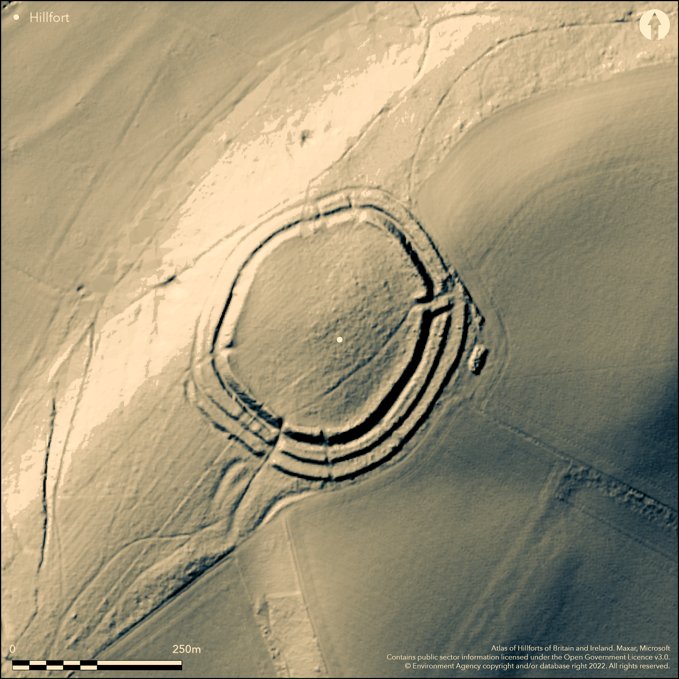
Formerly a fine, isolated, and almost circular, prominent, partial contour hillfort, now tree covered and part-ploughed, located on an interfluve position between the valley of the River Corve to the SE and various brooks to the NW. The interior is gently domed, falling more steeply on the N side. The three lines of well-preserved and widely-spaced defence are strongest on the weaker NE, E and S sides and here the main rampart is massive, being 15m wide and rising to 5.6m externally. The flat topped middle rampart is 16m wide and rises to 2.2m with a small bank or crest of 0.4m high along its outer edge. The outer bank, of some 12m width, rises to 2.3m in height, with a gradual inner and steep outer slope with a narrow crest. Hillwash has reduced the inner bank to a scarp on the NW and the middle and inner ramparts have been damaged near the SW entrance.There are traces of an outer ditch on the NE and SW sides, showing also now as a berm in places, but generally the three ditches are now buried features. The design of the defences tends to change along the escarpment. An E entrance has an out-turn on the S side, with a simpler, but damaged by forestry operations, entrance to the SW. Undated. On 1st Ed OS map (1885-1900)
Citizen Science: ✗
Reliability of Data: Confirmed
Reliability of Interpretation: Confirmed
X: -294591 Y: 6899138 (EPSG: 3857)
Longitude: -2.646357507573166 Latitude: 52.54425467403462 (EPSG:4326)
Country: England
Current County or Unitary Authority: Shropshire
Historic County: Shropshire
Current Parish/Community/Council/Townland: Rushbury
Hillwash has reduced the inner bank to a scarp on the NW and the middle and inner ramparts have been damaged near the SW entrance, itself damaged by a forestry track, but generally ramparts well-preserved. Some windblow problems.
| Extant | ✓ |
| Cropmark | ✗ |
| Likely Destroyed | ✗ |
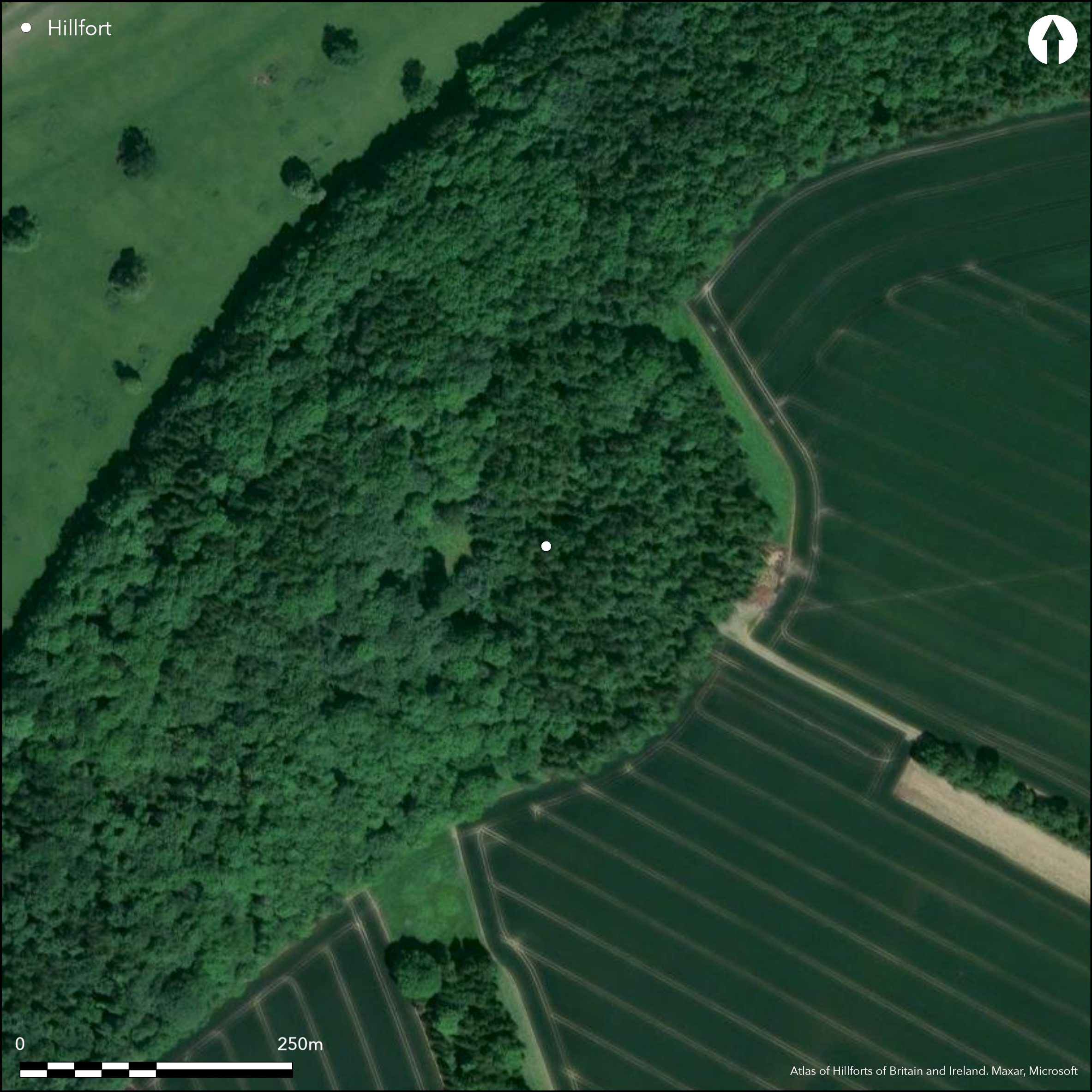
Conifers and old coppice; W part in deciduous woodland. Part-ploughed in the interior.
| Woodland | ✓ |
| Commercial Forestry Plantation | ✗ |
| Parkland | ✗ |
| Pasture (Grazing) | ✓ |
| Arable | ✓ |
| Scrub/Bracken | ✓ |
| Bare Outcrop | ✗ |
| Heather/Moorland | ✗ |
| Heath | ✗ |
| Built-up | ✗ |
| Coastal Grassland | ✗ |
| Other | ✗ |
Located on an interfluve position between the valley of the River Corve and brooks. Interior gently domed.
| Contour Fort | ✗ |
| Partial Contour Fort | ✓ |
| Promontory Fort | ✗ |
| Hillslope Fort | ✗ |
| Level Terrain Fort | ✗ |
| Marsh Fort | ✗ |
| Multiple Enclosure Fort | ✗ |
| Hilltop | ✓ |
| Coastal Promontory | ✗ |
| Inland Promontory | ✗ |
| Valley Bottom | ✗ |
| Knoll/Hillock/Outcrop | ✗ |
| Ridge | ✗ |
| Cliff/Plateau-edge/Scarp | ✗ |
| Hillslope | ✗ |
| Lowland | ✗ |
| Spur | ✗ |
Dominant Topographic Feature: Hill top.
| North | ✓ |
| Northeast | ✗ |
| East | ✗ |
| Southeast | ✗ |
| South | ✗ |
| Southwest | ✗ |
| West | ✗ |
| Northwest | ✗ |
| Level | ✗ |
Altitude: 280.0m
N/A
None
Reliability: D - None
| Pre 1200BC | ✗ |
| 1200BC - 800BC | ✗ |
| 800BC - 400BC | ✗ |
| 400BC - AD50 | ✗ |
| AD50 - AD400 | ✗ |
| AD400 - AD 800 | ✗ |
| Post AD800 | ✗ |
| Unknown | ✓ |
| Pre Hillfort: | None |
| Post Hillfort: | None |
On 1st Ed OS map (1885-1900). Air Photograph Interpretation RCHME: Marches Uplands NMP 1993-2000. Shropshire Council survey 2012.
| Other (2012): | Shropshire Council survey. |
| 1st Identified Map Depiction (None): | 1st Ed OS |
| Other (None): | Air Photograph Interpretation RCHME: Marches Uplands NMP. |
None
Springs located 0.3km outside the fort.
| None | ✓ |
| Spring | ✗ |
| Stream | ✗ |
| Pool | ✗ |
| Flush | ✗ |
| Well | ✗ |
| Other | ✗ |
None
| No Known Features | ✓ |
| Round Stone Structures | ✗ |
| Rectangular Stone Structures | ✗ |
| Curvilinear Platforms | ✗ |
| Other Roundhouse Evidence | ✗ |
| Pits | ✗ |
| Quarry Hollows | ✗ |
| Other | ✗ |
None
| No Known Excavation | ✓ |
| Pits | ✗ |
| Postholes | ✗ |
| Roundhouses | ✗ |
| Rectangular Structures | ✗ |
| Roads/Tracks | ✗ |
| Quarry Hollows | ✗ |
| Other | ✗ |
| Nothing Found | ✗ |
None
| No Known Geophysics | ✓ |
| Pits | ✗ |
| Roundhouses | ✗ |
| Rectangular Structures | ✗ |
| Roads/Tracks | ✗ |
| Quarry Hollows | ✗ |
| Other | ✗ |
| Nothing Found | ✗ |
None
| No Known Finds | ✓ |
| Pottery | ✗ |
| Metal | ✗ |
| Metalworking | ✗ |
| Human Bones | ✗ |
| Animal Bones | ✗ |
| Lithics | ✗ |
| Environmental | ✗ |
| Other | ✗ |
None
| APs Not Checked | ✓ |
| None | ✗ |
| Roundhouses | ✗ |
| Rectangular Structures | ✗ |
| Pits | ✗ |
| Postholes | ✗ |
| Roads/Tracks | ✗ |
| Other | ✗ |
Original entrances on the E and SW sides. Modern forestry gaps on the S and N sides. That on E out-turned on S side. Simple entrance but damaged on the SW.
| 4: | Modern forestry gaps on the S and N sides. |
| 2: | Original entrances on the E and SW sides. |
Guard Chambers: ✗
Chevaux de Frise: ✗
| 1. Out-turned (East): | Out-turned on the S side. |
| 2. Simple Gap (South west): | Simple entrance but damaged. |
The three lines of well-preserved and widely-spaced defence are strongest on the weaker NE, E and S sides and here the main rampart is massive, being 15m wide and rising to 5.6m externally. The flat topped middle rampart is 16m wide and rises to 2.2m with a small bank or creat of 0.4m high along its outer edge. The outer bank, of some 12m width, rises to 2.3m in height, with a gradual inner and steep outer slope with a narrow crest. Hillwash has reduced the inner bank to a scarp on the NW and the middle and inner ramparts have been damaged near the SW entrance. Ditches (3) now mostly as buried features, but traces of outer ditch on the NE and SW sides.
| Area 1: | 2.2ha. |
| Total: | 2.2ha. |
Total Footprint Area: Noneha.
None
| ✗ | None |
| ✓ | Three ramparts complete the circuit. |
| NE Quadrant: | 3 |
| SE Quadrant: | 3 |
| SW Quadrant: | 3 |
| NW Quadrant: | 3 |
| Total: | 3 |
| Partial Univallate | ✗ |
| Univallate | ✗ |
| Partial Bivallate | ✗ |
| Bivallate | ✗ |
| Partial Multivallate | ✗ |
| Multivallate | ✓ |
| Unknown | ✗ |
| Partial Univallate | ✗ |
| Univallate | ✗ |
| Partial Bivallate | ✗ |
| Bivallate | ✗ |
| Partial Multivallate | ✗ |
| Multivallate | ✗ |
Evidence of a berm in places.
| None | ✗ |
| Earthen Bank | ✓ |
| Stone Wall | ✗ |
| Rubble | ✗ |
| Wall-walk | ✗ |
| Evidence of Timber | ✗ |
| Vitrification | ✗ |
| Other Burning | ✗ |
| Palisade | ✗ |
| Counter Scarp Bank | ✗ |
| Berm | ✓ |
| Unfinished | ✗ |
| Other | ✗ |
None
| None | ✗ |
| Earthen Bank | ✗ |
| Stone Wall | ✗ |
| Murus Duplex | ✗ |
| Timber-framed | ✗ |
| Timber-laced | ✗ |
| Vitrification | ✗ |
| Other Burning | ✗ |
| Palisade | ✗ |
| Counter Scarp Bank | ✗ |
| Berm | ✗ |
| Unfinished | ✗ |
| No Known Excavation | ✓ |
| Other | ✗ |
| ✗ | None |
| ✓ | Ditches now mostly as buried features, but traces of outer ditch on the NE and SW sides. |
Number of Ditches: 3
| ✗ | None |
Dorling, P. and Wigley, A. 2012: Assessment of the archaeological and conservation status of major later prehistoric enclosures in Herefordshire and Shropshire, EH PNUM, Version 3.2, Hereford and Shrewsbury: Herefordshire Council/Shropshire Council.
Page, W. ed. 1908. Victoria County History of Shropshire, 1, 337, Institute of Historical Research.
Atlas of Hillforts:
Wikidata:
This work is licensed under CC BY-SA 4.0![]()
![]()
![]() and should be cited as:
and should be cited as:
Lock, Gary and Ralston, Ian. 2024. Atlas of Hillforts of Britain and Ireland. Available at: https://hillforts.arch.ox.ac.uk
Document Version 1.1