LiDAR 1m DTM Hillshade
Satellite Imagery
LiDAR 1m DTM Hillshade
Satellite Imagery
Scroll left/right to view further images.
HER: Shropshire 2541 (None)
NMR: SO 49 NE 28 (109182)
SM: 1008490
NGR: SO 494974
X: 349432 Y: 297411 (OSGB36)
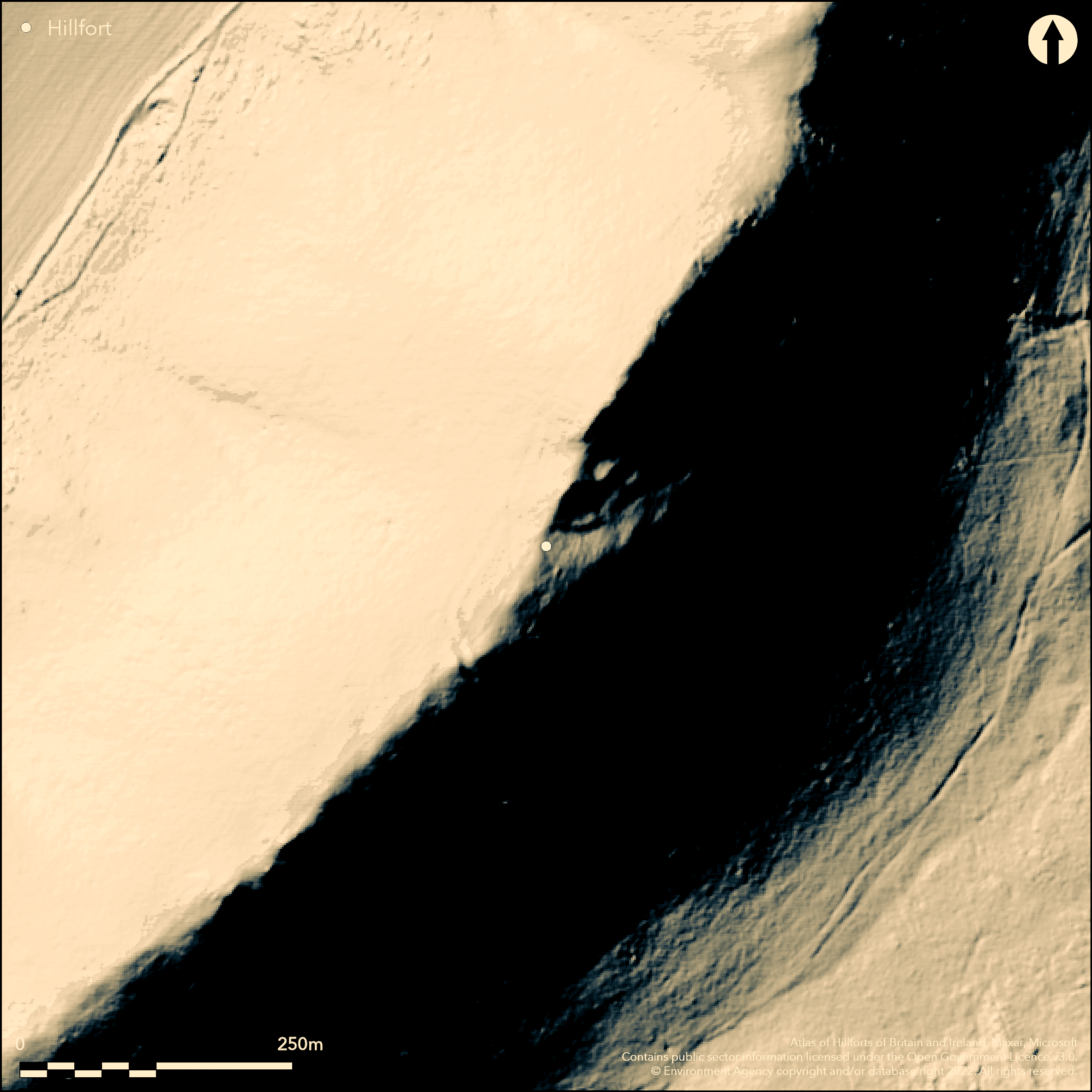
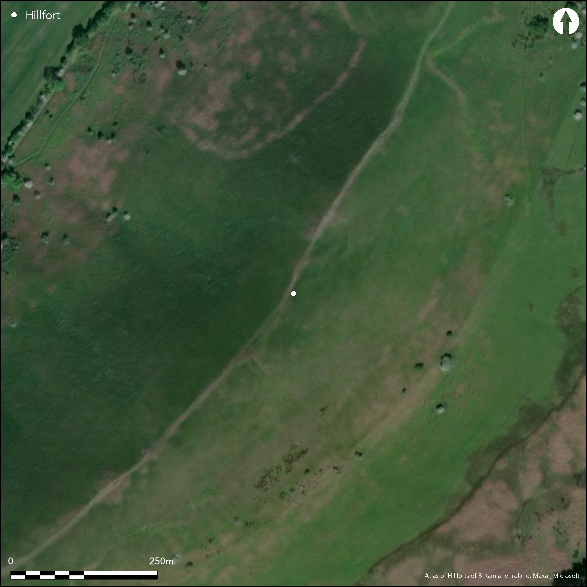
Located on the very exposed sharp ridge of The Lawley, the very distinctive razor-edged hill next (NE) to Caer Caradoc (Atlas No), and surrounded by precipitous slopes on all sides. A cross-dyke some 100m long crosss the the ridge from the NW to SE, SW of the trig point on the summit of the hill, as a well-defined and and partly rock-cut ditch c. 8m wide and 1.5m deep and with an internal bank c. 0.6m wide and 0.9m high. The ditch fades downslope and at the NW side is a slight scarp running along the slopes to beyond the trig point and to return around the NE side of the summit. An entrance was probably located around the S end of the bank. Towards the N end of the site a possible hut platform is visible, scooped out of the E-facing slope and measuring 11m by 7m. No other sign of activity can be seen. Its function is hotly debated and has been suggested as a territorial boundary site of mid to late Bronze Age date, or possibly univallate hillfort remains. The site is very exposed, open, unimproved upland grassland. Undated.
Citizen Science: ✗
Reliability of Data: Confirmed
Reliability of Interpretation: Unconfirmed
X: -305861 Y: 6904243 (EPSG: 3857)
Longitude: -2.74759185134974 Latitude: 52.57213069694558 (EPSG:4326)
Country: England
Current County or Unitary Authority: Shropshire
Historic County: Shropshire
Current Parish/Community/Council/Townland: Longnor
Vestiges remain of the site with some recreation erosion effects.
| Extant | ✓ |
| Cropmark | ✗ |
| Likely Destroyed | ✗ |
Upland acid grassland pasture.
| Woodland | ✗ |
| Commercial Forestry Plantation | ✗ |
| Parkland | ✗ |
| Pasture (Grazing) | ✓ |
| Arable | ✗ |
| Scrub/Bracken | ✗ |
| Bare Outcrop | ✗ |
| Heather/Moorland | ✗ |
| Heath | ✗ |
| Built-up | ✗ |
| Coastal Grassland | ✗ |
| Other | ✗ |
The exact type of hillfort (if indeed one) cannot be exactly defined and partial contour site only estimated, though site makes full use of the topography. Located on the very exposed sharp ridge of The Lawley, the very distinctive razor-edged hill next (NE) to Caer Caradoc and surrounded by precipitous slopes on all sides.
| Contour Fort | ✗ |
| Partial Contour Fort | ✓ |
| Promontory Fort | ✗ |
| Hillslope Fort | ✗ |
| Level Terrain Fort | ✗ |
| Marsh Fort | ✗ |
| Multiple Enclosure Fort | ✗ |
| Hilltop | ✗ |
| Coastal Promontory | ✗ |
| Inland Promontory | ✗ |
| Valley Bottom | ✗ |
| Knoll/Hillock/Outcrop | ✗ |
| Ridge | ✓ |
| Cliff/Plateau-edge/Scarp | ✗ |
| Hillslope | ✗ |
| Lowland | ✗ |
| Spur | ✗ |
Dominant Topographic Feature: Summit ridge of The Lawley.
| North | ✗ |
| Northeast | ✗ |
| East | ✗ |
| Southeast | ✓ |
| South | ✗ |
| Southwest | ✗ |
| West | ✗ |
| Northwest | ✗ |
| Level | ✗ |
Altitude: 377.0m
N/A
Use of cross-dykes suggest a mid to late Bronze Age origin of the site.
Reliability: D - None
| Pre 1200BC | ✗ |
| 1200BC - 800BC | ✗ |
| 800BC - 400BC | ✗ |
| 400BC - AD50 | ✗ |
| AD50 - AD400 | ✗ |
| AD400 - AD 800 | ✗ |
| Post AD800 | ✗ |
| Unknown | ✓ |
| Pre Hillfort: | None |
| Post Hillfort: | None |
| Morphology/Earthwork/Typology: | Use of cross-dykes suggest a mid to late Bronze Age origin of the site. |
Field observation Ordnance Survey 1979. Field observation Shropshire CC 1978. Shropshire Council survey 2012.
| Other (1978): | Field observation Shropshire CC. |
| Other (1979): | Field observation OS. |
| Other (2009): | Visited by Hillfort Study Group |
| Other (2012): | Shropshire Council survey. |
Towards the N end of the site a possible hut platform is visible, scooped out of the E-facing slope and measuring 11m by 7m. No other sign of activity can be seen.
Spring located downslope 0.5km outside the fort.
| None | ✓ |
| Spring | ✗ |
| Stream | ✗ |
| Pool | ✗ |
| Flush | ✗ |
| Well | ✗ |
| Other | ✗ |
Towards the N end of the site a possible hut platform is visible, scooped out of the E-facing slope and measuring 11m by 7m. No other sign of activity can be seen.
| No Known Features | ✗ |
| Round Stone Structures | ✗ |
| Rectangular Stone Structures | ✗ |
| Curvilinear Platforms | ✓ |
| Other Roundhouse Evidence | ✗ |
| Pits | ✗ |
| Quarry Hollows | ✗ |
| Other | ✗ |
None
| No Known Excavation | ✓ |
| Pits | ✗ |
| Postholes | ✗ |
| Roundhouses | ✗ |
| Rectangular Structures | ✗ |
| Roads/Tracks | ✗ |
| Quarry Hollows | ✗ |
| Other | ✗ |
| Nothing Found | ✗ |
None
| No Known Geophysics | ✓ |
| Pits | ✗ |
| Roundhouses | ✗ |
| Rectangular Structures | ✗ |
| Roads/Tracks | ✗ |
| Quarry Hollows | ✗ |
| Other | ✗ |
| Nothing Found | ✗ |
None
| No Known Finds | ✓ |
| Pottery | ✗ |
| Metal | ✗ |
| Metalworking | ✗ |
| Human Bones | ✗ |
| Animal Bones | ✗ |
| Lithics | ✗ |
| Environmental | ✗ |
| Other | ✗ |
None
| APs Not Checked | ✓ |
| None | ✗ |
| Roundhouses | ✗ |
| Rectangular Structures | ✗ |
| Pits | ✗ |
| Postholes | ✗ |
| Roads/Tracks | ✗ |
| Other | ✗ |
An entrance was probably located around the S end of the bank, simple gap. Neither form nor position determined exactly.
| 1: | Possible site only. |
| 2: | An entrance was probably located around the S end of the bank. |
Guard Chambers: ✗
Chevaux de Frise: ✗
| 1. Simple Gap (South): | Possible form and location of entrance only. |
A cross-dyke some 100m long crosss the the ridge from the NW to SE, SW of the trig point on the summit of the hill, as a well-defined and and partly rock-cut ditch c. 8m wide and 1.5m deep and with an internal bank c. 0.6wide and 0.9m high. The ditch fades downslope and at the NW side is a slight scarp running along the slopes to beyond the trig point and to return around the NE side of the summit.
| Area 1: | 1.0ha. |
| Total: | 1.0ha. |
Total Footprint Area: Noneha.
None
| ✗ | Area c. 1ha not exact. |
| ✗ | None |
| NE Quadrant: | 1 |
| SE Quadrant: | 1 |
| SW Quadrant: | 1 |
| NW Quadrant: | 1 |
| Total: | 1 |
| Partial Univallate | ✗ |
| Univallate | ✓ |
| Partial Bivallate | ✗ |
| Bivallate | ✗ |
| Partial Multivallate | ✗ |
| Multivallate | ✗ |
| Unknown | ✗ |
| Partial Univallate | ✗ |
| Univallate | ✗ |
| Partial Bivallate | ✗ |
| Bivallate | ✗ |
| Partial Multivallate | ✗ |
| Multivallate | ✗ |
None
| None | ✗ |
| Earthen Bank | ✓ |
| Stone Wall | ✗ |
| Rubble | ✗ |
| Wall-walk | ✗ |
| Evidence of Timber | ✗ |
| Vitrification | ✗ |
| Other Burning | ✗ |
| Palisade | ✗ |
| Counter Scarp Bank | ✗ |
| Berm | ✗ |
| Unfinished | ✗ |
| Other | ✗ |
None
| None | ✗ |
| Earthen Bank | ✗ |
| Stone Wall | ✗ |
| Murus Duplex | ✗ |
| Timber-framed | ✗ |
| Timber-laced | ✗ |
| Vitrification | ✗ |
| Other Burning | ✗ |
| Palisade | ✗ |
| Counter Scarp Bank | ✗ |
| Berm | ✗ |
| Unfinished | ✗ |
| No Known Excavation | ✓ |
| Other | ✗ |
| ✗ | None |
| ✓ | Partly rock-cut ditch in evidence. |
Number of Ditches: 1
| ✗ | None |
Dorling, P. and Wigley, A. 2012. Assessment of the archaeological and conservation status of major later prehistoric enclosures in Herefordshire and Shropshire, EH PNUM, Version 3.2, Hereford and Shrewsbury: Herefordshire Council/Shropshire Council.
Guilbert, G.C. 1975. Planned hillfort interiors, Proc Prehist Soc, 41, 203-21.
Page, W. ed. 1908. Victoria County History of Shropshire, 1, 360, Institute of Historical Research.
Atlas of Hillforts:
Wikidata:
This work is licensed under CC BY-SA 4.0![]()
![]()
![]() and should be cited as:
and should be cited as:
Lock, Gary and Ralston, Ian. 2024. Atlas of Hillforts of Britain and Ireland. Available at: https://hillforts.arch.ox.ac.uk
Document Version 1.1