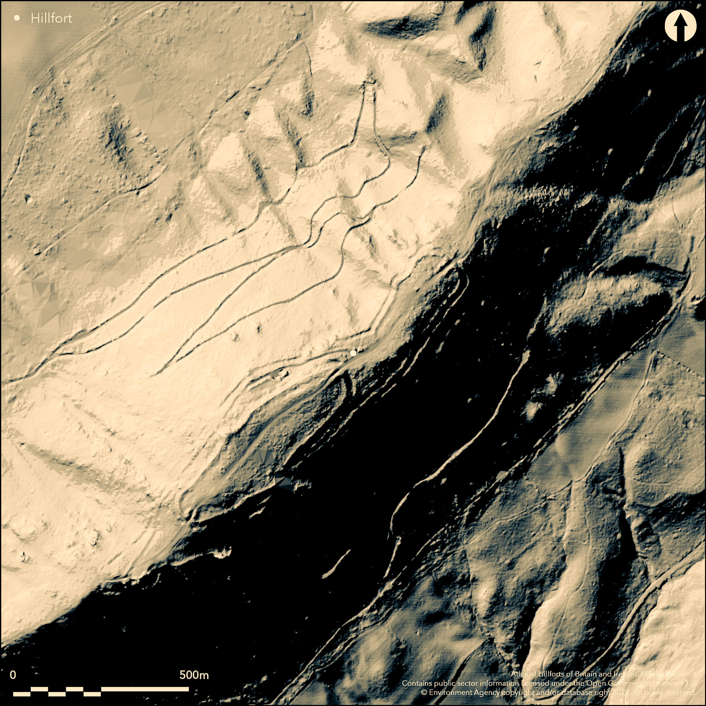
LiDAR 1m DTM Hillshade
Satellite Imagery
LiDAR 1m DTM Hillshade
Satellite Imagery
Scroll left/right to view further images.
HER: Shropshire 1069 (None)
NMR: SJ 60 NW 3 (71909)
SM: 1021275
NGR: SJ 630083
X: 363048 Y: 308337 (OSGB36)
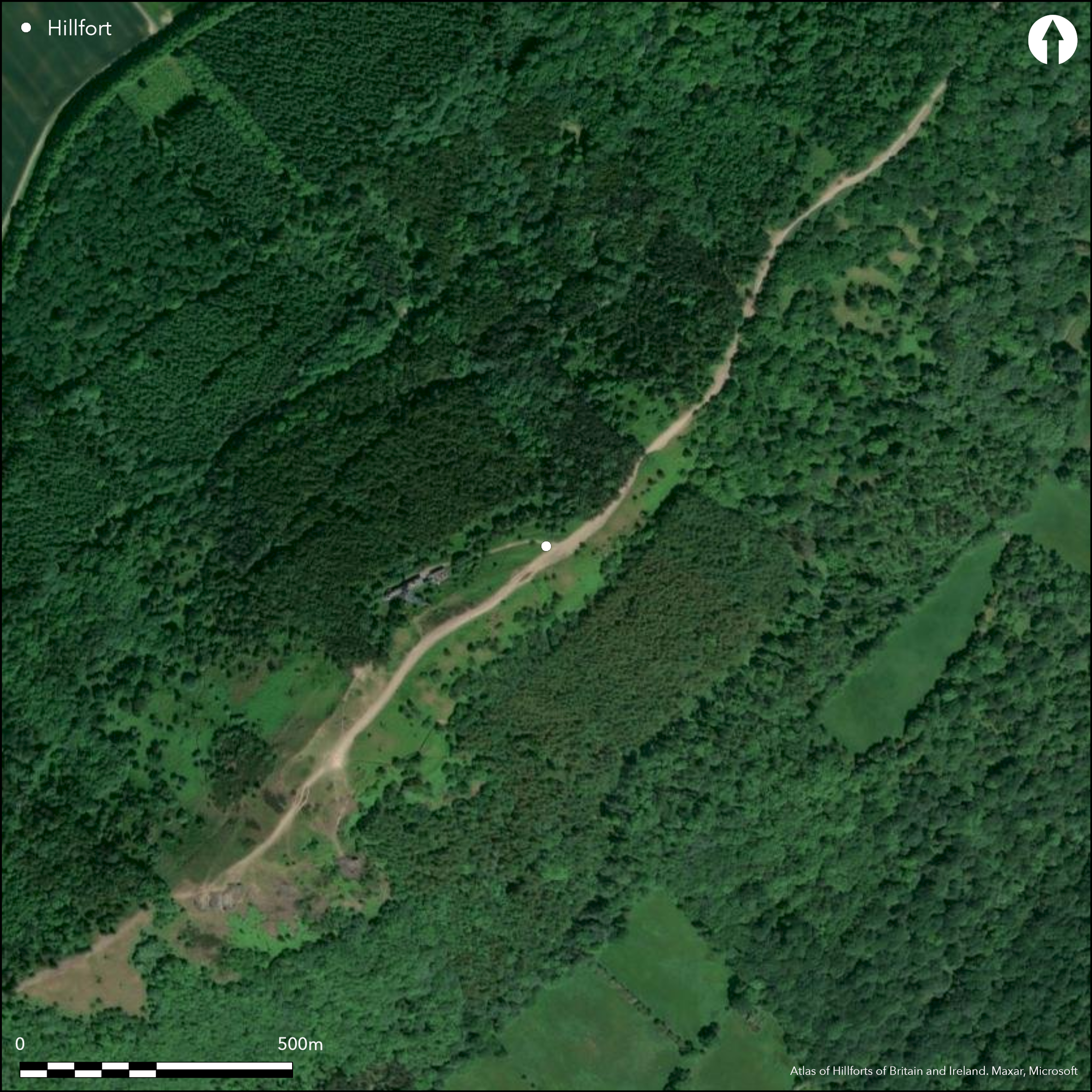
Major and important contour hillfort located on the 'hogsback' ridge of The Wrekin, with steep slopes on all sides above the River Severn to the S and River Tern to the N. There are two enclosures, reflecting the phased construction and occupation of the site. Unusually for a hillfort, an outer enclosure of c. 8ha, with mainly double earth and stone ramparts and infilled ditch, is thought to have been constructed first. This shows today as a series of terraces to 5m in height utilising the rock outcrops and extending around the hillsides and dates to around 7th-5th. centuries BC, lasting till around 5th-4th centuries BC. An inner enclosure of 3.5ha with single rampart, ditch and counterscarp was then constructed and the outer enclosure abandoned, but then to be reoccupied about 100 years later. The bank of the inner enclosure with quarry ditch was initially of clay-stone construction with external dry-stone retaining wall, but was later remodelled with an enlarged rampart and a timber palisade. The ramparts are most substantial near to the entrances, elsewhere now just low mounds. The fort is noted for its fine inturned entrances to both enclosures with guard chambers. Excavations in 1939 and 1973, the latter in advance of the construction of a television mast, found post-built structures (with three to four rebuilding phases) and hearths set into the hillside and possible storage pits. Late Bronze Age pottery of 9th-8th centuries BC suggest an early origin to the fort, in keeping with other major Marches sites such as Y Breiddin (Atlas No 1276), which is visible from The Wrekin. There is a Bronze Age cairn located at the highest point of the hill. The fort was taken by the Roman army c. 48-50 AD and two javelin heads were found of mid 1st century AD date. Essentially moorland with bracken, scrub and tree growth, rock outcrops and modern built features. SSSI. Although damaged by WWII searchlight battery and warning beacon construction and the 1973 television transmitter between the two enclosures to the NW, the site is large enough to show its salient features well. On 1st Ed OS map (1885-1900).
Citizen Science: ✗
Reliability of Data: Confirmed
Reliability of Interpretation: Confirmed
X: -283633 Y: 6922454 (EPSG: 3857)
Longitude: -2.5479198672110615 Latitude: 52.67144805514039 (EPSG:4326)
Country: England; None
Current County or Unitary Authority: Shropshire
Historic County: Shropshire
Current Parish/Community/Council/Townland: Little Wenlock; Telford and Wrekin
Although damaged by WWII searchlight battery and warning beacon construction and the 1973 television transmitter between the two enclosures to the NW, the site is large enough to show its salient features well. Bracken, scrub and tree growth.
| Extant | ✓ |
| Cropmark | ✗ |
| Likely Destroyed | ✗ |
Essentially moorland with rock outcrops and modern built features. SSSI.
| Woodland | ✓ |
| Commercial Forestry Plantation | ✗ |
| Parkland | ✗ |
| Pasture (Grazing) | ✗ |
| Arable | ✗ |
| Scrub/Bracken | ✓ |
| Bare Outcrop | ✗ |
| Heather/Moorland | ✓ |
| Heath | ✗ |
| Built-up | ✓ |
| Coastal Grassland | ✗ |
| Other | ✓ |
Both the inner and outer enclosures follow the contours with slopes in all directions. Steep hogsback ridge located above the River Severn on the S and River Tern to the N.
| Contour Fort | ✓ |
| Partial Contour Fort | ✗ |
| Promontory Fort | ✗ |
| Hillslope Fort | ✗ |
| Level Terrain Fort | ✗ |
| Marsh Fort | ✗ |
| Multiple Enclosure Fort | ✗ |
| Hilltop | ✓ |
| Coastal Promontory | ✗ |
| Inland Promontory | ✗ |
| Valley Bottom | ✗ |
| Knoll/Hillock/Outcrop | ✗ |
| Ridge | ✓ |
| Cliff/Plateau-edge/Scarp | ✗ |
| Hillslope | ✗ |
| Lowland | ✗ |
| Spur | ✗ |
Dominant Topographic Feature: The Wrekin.
| North | ✗ |
| Northeast | ✗ |
| East | ✗ |
| Southeast | ✗ |
| South | ✗ |
| Southwest | ✗ |
| West | ✗ |
| Northwest | ✗ |
| Level | ✓ |
Altitude: 407.0m
Boundary Type: Parish/Townland
7th century BC to c. AD 49. Late Bronze Age pottery of 9th-8th centuries BC suggest an early origin to the fort, in keeping with other major Marches sites such as Y Breiddin. C14 dating of charcoal from a post-built structure found dates of 7th-5th and 5th-4th centuries BC, whilst two javelin heads were found of mid 1st century AD date.
Reliability: A - High
| Pre 1200BC | ✗ |
| 1200BC - 800BC | ✓ |
| 800BC - 400BC | ✓ |
| 400BC - AD50 | ✓ |
| AD50 - AD400 | ✓ |
| AD400 - AD 800 | ✗ |
| Post AD800 | ✗ |
| Unknown | ✗ |
| Pre Hillfort: | None |
| Post Hillfort: | None |
| Artefactual: | Late Bronze Age pottery of 9th-8th centuries BC suggest an early origin to the fort, in keeping with other major Marches sites such as Y Breiddin, |
| Artefactual: | Two javelin heads were found of mid 1st century AD date. |
| C14: | C14 dating of charcoal from a post-built structure found dates of 7th-5th and 5th-4th centuries BC. |
On 1st Ed OS map (1885-1900). Excavations by K.M. Kenyon 1939 and 1973 by S.C. Stanford, 1973, the latter in advance of the construction of a television mast. Field observation Ordnance Survey 1970, 1975. Evaluation Oxford Arch. 1998. Excavation Oxford Arch. Unit 1999-2000. Watching Brief Ironbridge Arch/Nexus Heritage 2010. Shropshire Council survey 2012.
| Excavation (1939): | Excavations by Kenyon. |
| Excavation (1973): | Excavations by S. Stanford in advance of development. |
| Other (1977): | Visit by Hillfort Study Group |
| Other (1998): | Evaluation Oxford Arc. Unit. |
| Other (2009): | Visited by Hillfort Study Group |
| Other (2010): | Watching Brief Ironbridge Arch/Nexus Heritage. |
| Other (2012): | Shropshire Council survey. |
| 1st Identified Map Depiction (None): | 1st Ed OS |
| Other (None): | Field observation OS. |
| Excavation (None): | Oxford Arch. Unit. |
Excavations in 1939 and 1973, the latter in advance of the construction of a television mast, found post-built structures (with three to four rebuilding phases) and hearths set into the hillside and possible storage pits. Late Bronze Age pottery of 9th-8th centuries BC suggest an early origin to the fort, in keeping with other major Marches sites such as Y Breiddin, which is visible from The Wrekin. Late Bronze Age pottery (c. 9th-8th centuries BC) and two Roman javelin heads. found.
Spring located 0.3km outside the fort.
| None | ✓ |
| Spring | ✗ |
| Stream | ✗ |
| Pool | ✗ |
| Flush | ✗ |
| Well | ✗ |
| Other | ✗ |
Surface evidence of quarry ditch.
| No Known Features | ✗ |
| Round Stone Structures | ✗ |
| Rectangular Stone Structures | ✗ |
| Curvilinear Platforms | ✗ |
| Other Roundhouse Evidence | ✗ |
| Pits | ✗ |
| Quarry Hollows | ✓ |
| Other | ✗ |
Excavations in 1939 and 1973, the latter in advance of the construction of a television mast, found post-built structures (with three to four rebuilding phases) and hearths set into the hillside and possible storage pits. Late Bronze Age pottery of 9th-8th centuries BC suggest an early origin to the fort, in keeping with other major Marches sites such as Y Breiddin, which is visible from The Wrekin.
| No Known Excavation | ✗ |
| Pits | ✓ |
| Postholes | ✗ |
| Roundhouses | ✗ |
| Rectangular Structures | ✓ |
| Roads/Tracks | ✗ |
| Quarry Hollows | ✗ |
| Other | ✗ |
| Nothing Found | ✗ |
None
| No Known Geophysics | ✓ |
| Pits | ✗ |
| Roundhouses | ✗ |
| Rectangular Structures | ✗ |
| Roads/Tracks | ✗ |
| Quarry Hollows | ✗ |
| Other | ✗ |
| Nothing Found | ✗ |
Late Bronze Age pottery (c. 9th-8th centuries BC). Two Roman javelin heads. Charcoal.
| No Known Finds | ✗ |
| Pottery | ✓ |
| Metal | ✓ |
| Metalworking | ✗ |
| Human Bones | ✗ |
| Animal Bones | ✗ |
| Lithics | ✗ |
| Environmental | ✓ |
| Other | ✗ |
None
| APs Not Checked | ✓ |
| None | ✗ |
| Roundhouses | ✗ |
| Rectangular Structures | ✗ |
| Pits | ✗ |
| Postholes | ✗ |
| Roads/Tracks | ✗ |
| Other | ✗ |
Inner enclosure entrances at the NE (Heaven Gate) and SW each with two rectangular guard chambers. Strong inturned entrance on the NE (Hell Gate) of the outer enclosure with guard chambers, but only remnants of the SW entrance survive.
| 4: | All breaks original. |
| 2: | Inner enclosure entrances at the NE (Heaven Gate) and SW each with two rectangular guard chambers. Strong inturned entrance on the NE (Hell Gate) of the outer enclosure with guard chambers, but only remnants of the SW entrance survive. |
Guard Chambers: ✓
Chevaux de Frise: ✗
| 1. In-turned (North east): | Inner enclosure entrance at the NE (Heaven Gate) with two rectangular guard chambers. |
| 1. Recesses/Guard Chambers (North east): | Rectangular guard chambers. |
| 2. In-turned (South west): | Inner enclosure entrance at SW with two rectangular guard chambers. |
| 2. Recesses/Guard Chambers (South west): | Rectangular guard chambers. |
| 3. In-turned (North east): | Strong inturned entrance on the NE (Hell Gate) of the outer enclosure with guard chambers. |
| 3. Recesses/Guard Chambers (North east): | None |
| 4. In-turned (South west): | Only remnants of the SW entrance survive. |
There are two enclosures, reflecting the phased construction and occupation of the site. Unusually for a hillfort, an outer enclosure of c. 8ha, with mainly double earth and stone ramparts and infilled ditch, is thought to have been constructed first. This shows today as a series of terraces to 5m in height utilising the rock outcrops and extending around the hillsides and dates to around 7th-5th centuries BC, lasting till around 5th-4th centuries BC. An inner enclosure of 3.5ha with single rampart, ditch and counterscarp was then constructed and the outer enclosure abandoned, but then to be reoccupied about 100 years later. The bank of the inner enclosure, with quarry ditch, was initially of clay-stone construction with external dry-stone retaining wall, but was later remodelled with an enlarged rampart and a timber palisade. The ramparts are most substantial near to the entrances, elsewhere now just low mounds.
| Area 1: | 3.5ha. |
| Area 2: | 8.0ha. |
| Total: | 8.0ha. |
Total Footprint Area: Noneha.
None
| ✓ | The inner enclosure encloses 3.5ha and is of later date than the outer enclosure. Excavations by S.C. Stanford 1973 found post-built structures with three to four rebuilding phases. |
| ✓ | None |
| NE Quadrant: | 2 |
| SE Quadrant: | 2 |
| SW Quadrant: | 2 |
| NW Quadrant: | 2 |
| Total: | 2 |
| Partial Univallate | ✗ |
| Univallate | ✗ |
| Partial Bivallate | ✗ |
| Bivallate | ✓ |
| Partial Multivallate | ✗ |
| Multivallate | ✗ |
| Unknown | ✗ |
| Partial Univallate | ✗ |
| Univallate | ✓ |
| Partial Bivallate | ✗ |
| Bivallate | ✗ |
| Partial Multivallate | ✗ |
| Multivallate | ✗ |
The structure of the ramparts was determined by excavation, but an earthen and stone bank and counterscarp are evident.
| None | ✗ |
| Earthen Bank | ✓ |
| Stone Wall | ✗ |
| Rubble | ✓ |
| Wall-walk | ✗ |
| Evidence of Timber | ✗ |
| Vitrification | ✗ |
| Other Burning | ✗ |
| Palisade | ✗ |
| Counter Scarp Bank | ✓ |
| Berm | ✗ |
| Unfinished | ✗ |
| Other | ✗ |
Unusually for a hillfort, an outer enclosure of c. 8ha, with mainly double earth and stone ramparts and infilled ditch, is thought to have been constructed first. An inner enclosure of 3.5ha with single rampart, ditch and counterscarp was then constructed and the outer enclosure abandoned and later re-occupied. The bank of the inner enclosure with quarry ditch was initially of clay-stone construction with external dry-stone retaining wall, but was later remodelled with an enlarged rampart and a timber palisade.
| None | ✗ |
| Earthen Bank | ✓ |
| Stone Wall | ✓ |
| Murus Duplex | ✗ |
| Timber-framed | ✗ |
| Timber-laced | ✓ |
| Vitrification | ✗ |
| Other Burning | ✗ |
| Palisade | ✓ |
| Counter Scarp Bank | ✓ |
| Berm | ✗ |
| Unfinished | ✗ |
| No Known Excavation | ✗ |
| Other | ✗ |
| ✗ | None |
| ✓ | The ditches are variable around the site. |
Number of Ditches: 2
| ✗ | None |
Dorling, P. and Wigley, A. 2012. Assessment of the archaeological and conservation status of major later prehistoric enclosures in Herefordshire and Shropshire, EH PNUM, Version 3.2, Hereford and Shrewsbury: Herefordshire Council/Shropshire Council.
Kenyon, K.M. 1942. Excavations at the Wrekin, Shropshire 1939, Archaeol J, 99, 99-109.
Stanford, S.C. 1985. The Wrekin hillfort: excavations 1973, Archaeol J, 141, 61-90.
Watson 2002: Shropshire, an archaeologiocal guide, 33-4, Shrewsbury: Shropshire Books.
Atlas of Hillforts:
Wikidata:
This work is licensed under CC BY-SA 4.0![]()
![]()
![]() and should be cited as:
and should be cited as:
Lock, Gary and Ralston, Ian. 2024. Atlas of Hillforts of Britain and Ireland. Available at: https://hillforts.arch.ox.ac.uk
Document Version 1.1