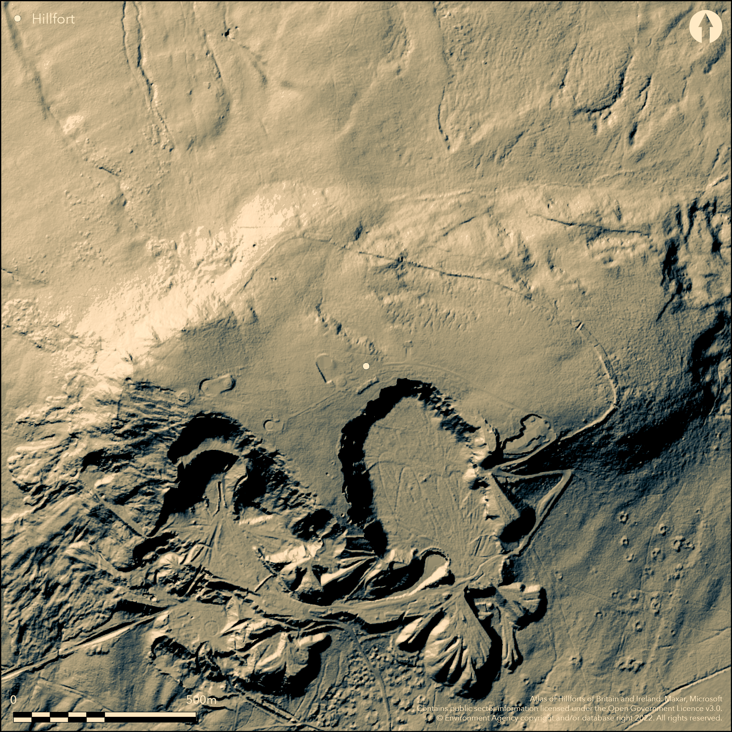
LiDAR 1m DTM Hillshade

Satellite Imagery
LiDAR 1m DTM Hillshade
Satellite Imagery
Scroll left/right to view further images.
HER: Shropshire 427 (None)
NMR: SO 57 NE 4 (110933)
SM: 1008391
NGR: SO 595779
X: 359516 Y: 277973 (OSGB36)
High and exposed contour hillfort, the largest of the three hillforts (and at c. 29.6ha one of the largest in England) formerly on the Clees (Brown and Titterstone), that dominate SE Shropshire overlooking the River Teme and lower lying valleys to the west and Ledwyche Brook and River Rea to the E. Despite being nearly lost on the S side to abandoned quarrying, surprisingly good stone ramparts remain over part of the circuit. There is a single stone rampart to the N and E of the hill up to 13m in width and up to 2.4m on the exterior face. which shows as a tumble of scree. To small sections of turf covered stone bank remain on the S side between the two quarries that here cut into the enclosure. No ditch is visible. O'Neil in his 1932 rescue excavations suggested two phases of construction: Phase I had an earth rampart revetted in front with a timber palisade (suggested as late Bronze Age), a line of post-holes being found. The entrance was incurved with probable bridge and turfed walk over. A period of decay was followed in Phase II by a heightened rampart, faced with dry-stone walling, its collapse shown today as scree lying outside the foot of the bank. There were elaborate guard chambers at the gate. There are two original entrances 'visible'. One (alleged) to the N, 4m wide, has a slight inturn, whilst that to the SE was also inturned and had evidence of guard chambers. This now forms the road and entrance to a CAA/Met Office radar station and is unrecognisable in form. Other gaps in ramparts result of O'Neil's excavation. There is a radar station in the interior. There are two ring cairns in the W quarter and possible, but undefined, evidence of occupation in the interior. Moorland grassy interior. On 1st Ed OS map (1885-1900).
Citizen Science: ✗
Reliability of Data: Confirmed
Reliability of Interpretation: Confirmed
X: -289034 Y: 6872454 (EPSG: 3857)
Longitude: -2.5964405787370564 Latitude: 52.39823580307426 (EPSG:4326)
Country: England; None
Current County or Unitary Authority: Shropshire
Historic County: Shropshire
Current Parish/Community/Council/Townland: Bitterley; Stoke St Milborough
Apart from two small sections between the two large quarries that bite into the fort, the S side has been lost to quarrying for dolorite. The excavated main SE entrance still has the remains of O'Neil's trench exposed. A CAA and Met Office radar station, constructed in the latter 20th century occupies part of the interior.
| Extant | ✓ |
| Cropmark | ✗ |
| Likely Destroyed | ✗ |
A CAA and Met Office radar station, constructed in the latter 20th century occupies part of the interior. Trenches. Quarries.
| Woodland | ✗ |
| Commercial Forestry Plantation | ✗ |
| Parkland | ✗ |
| Pasture (Grazing) | ✗ |
| Arable | ✗ |
| Scrub/Bracken | ✓ |
| Bare Outcrop | ✗ |
| Heather/Moorland | ✓ |
| Heath | ✓ |
| Built-up | ✓ |
| Coastal Grassland | ✗ |
| Other | ✓ |
Site slopes in most directions, but follows the contours. Located on the summit of Titterstone Clee, one of the Clee hills (with Brown), that dominate SE Shropshire overlooking the River Teme and lower lying valleys to the W and Ledwyche Brook and River Rea to the E.
| Contour Fort | ✓ |
| Partial Contour Fort | ✗ |
| Promontory Fort | ✗ |
| Hillslope Fort | ✗ |
| Level Terrain Fort | ✗ |
| Marsh Fort | ✗ |
| Multiple Enclosure Fort | ✗ |
| Hilltop | ✓ |
| Coastal Promontory | ✗ |
| Inland Promontory | ✗ |
| Valley Bottom | ✗ |
| Knoll/Hillock/Outcrop | ✗ |
| Ridge | ✗ |
| Cliff/Plateau-edge/Scarp | ✗ |
| Hillslope | ✗ |
| Lowland | ✗ |
| Spur | ✗ |
Dominant Topographic Feature: Summit of Titterstone Clee.
| North | ✓ |
| Northeast | ✗ |
| East | ✓ |
| Southeast | ✗ |
| South | ✓ |
| Southwest | ✗ |
| West | ✓ |
| Northwest | ✗ |
| Level | ✗ |
Altitude: 500.0m
Boundary Type: Parish/Townland
Late Bronze Age activity on the site in the presence of two ring cairns, a type of monument unusual for Shropshire and early phase of hillfort with timber revetted rampart. Probable Iron Age date to site Phase I and Phase II construction with post-Conquest Roman period dismantling of the gate.
Reliability: B - Medium
| Pre 1200BC | ✗ |
| 1200BC - 800BC | ✗ |
| 800BC - 400BC | ✓ |
| 400BC - AD50 | ✓ |
| AD50 - AD400 | ✓ |
| AD400 - AD 800 | ✗ |
| Post AD800 | ✗ |
| Unknown | ✗ |
| Pre Hillfort: | None |
| Post Hillfort: | None |
| Morphology/Earthwork/Typology: | Timber revetted rampart may be late Bronze Age. |
| Morphology/Earthwork/Typology: | Two late Bronze Age ring cairns in the interior. |
In Aubrey's Monumenta Britannica (1665-1693). On 1st Ed OS map (1885-1900). Rescue excavations by B.H.St.J. O'Neil 1932. Field observation Ordnance Survey 1968. Later investigation in advance of development by CAA and Met Office; BUFAU 1991. Shropshire Council survey 2012. Watching Brief SLR Consulting 2013. Watching Brief N. Baker 2015.
| Excavation (1932): | Rescue excavations by B.H.St.J. O'Neil. |
| Other (1968): | Field observation OS. |
| Other (1968): | Visit by Hillfort Study Group |
| Other (1991): | Investigations by CAA and Met Office (Anon). |
| Other (1991): | Evaluation BUFAU. |
| Other (2009): | Visited by Hillfort Study Group |
| Other (2012): | Shropshire Council survey 2012. |
| Other (2013): | Watching Brief SLR Consulting. |
| Other (2015): | Watching Brief N. Baker. |
| 1st Identified Written Reference (None): | Aubrey's Monumenta Britannica. |
| 1st Identified Map Depiction (None): | 1st Ed OS |
There are two ring cairns in the W quarter and possible, but undefined, evidence of occupation in the interior. Very small fragments of flint and possible pounders or sling stone.
Bensons Brook is located 0.3km outside the hillfort.
| None | ✓ |
| Spring | ✗ |
| Stream | ✗ |
| Pool | ✗ |
| Flush | ✗ |
| Well | ✗ |
| Other | ✗ |
There are two ring cairns in the W quarter and possible, but undefined, evidence of occupation in the interior.
| No Known Features | ✗ |
| Round Stone Structures | ✗ |
| Rectangular Stone Structures | ✗ |
| Curvilinear Platforms | ✗ |
| Other Roundhouse Evidence | ✗ |
| Pits | ✗ |
| Quarry Hollows | ✗ |
| Other | ✓ |
Undefined, evidence of occupation in the interior.
| No Known Excavation | ✗ |
| Pits | ✗ |
| Postholes | ✗ |
| Roundhouses | ✗ |
| Rectangular Structures | ✗ |
| Roads/Tracks | ✗ |
| Quarry Hollows | ✗ |
| Other | ✓ |
| Nothing Found | ✗ |
None
| No Known Geophysics | ✓ |
| Pits | ✗ |
| Roundhouses | ✗ |
| Rectangular Structures | ✗ |
| Roads/Tracks | ✗ |
| Quarry Hollows | ✗ |
| Other | ✗ |
| Nothing Found | ✗ |
Very small fragments of flint and possible pounders or slingstone.
| No Known Finds | ✗ |
| Pottery | ✗ |
| Metal | ✗ |
| Metalworking | ✗ |
| Human Bones | ✗ |
| Animal Bones | ✗ |
| Lithics | ✓ |
| Environmental | ✗ |
| Other | ✓ |
None
| APs Not Checked | ✓ |
| None | ✗ |
| Roundhouses | ✗ |
| Rectangular Structures | ✗ |
| Pits | ✗ |
| Postholes | ✗ |
| Roads/Tracks | ✗ |
| Other | ✗ |
There are two original entrances 'visible'. One (alleged) to the N 4m wide has a slight inturn, whilst that to the SE was also inturned and had evidence of guard chambers. This now forms the road and entrance to a CAA/Met Office radar station and is unrecognisable in form.
| 2: | Two entrances with other gaps being O'Neil's trenches of the 1932 excavation. |
| 2: | SE excavated entrance now lost in form due to road and access to radar station. |
Guard Chambers: ✓
Chevaux de Frise: ✗
| 1. In-turned (North): | Alleged entrance to the N 4m wide with a slight inturn, |
| 2. In-turned (South east): | SE excavated entrance now lost in form due to road and access to radar station. Formerly inturned with evidence of guard chambers. |
| 2. Recesses/Guard Chambers (South east): | Former evidence of guard chambers. |
Despite being nearly lost on the S side to abandoned quarrying, surprisingly good stone ramparts remain over part of the circuit. Phase I had an earth rampart revetted in front with a timber palisade, a line of post-holes being found. There is a single stone rampart to the N and E of the hill up to 13m in width and up to 2.4m on the exterior face. which shows as a tumble of scree. To small sections of turf covered stone bank remain on the S side between the two quarries that here cut into the enclosure. No ditch is visible.
| Area 1: | 29.6ha. |
| Total: | 29.6ha. |
Total Footprint Area: Noneha.
There is a single stone rampart to the north and east of the hill up to 13 m in width and up to 2.4 m on the exterior face. which shows as a tumble of scree. To small sections of turf covered stone bank remain on the south side between the two quarries that here cut into the enclosure.
| ✓ | Two phases of construction found by O'Neil. Large site much affected by quarrying make the actual enclosed area difficult to define exactly. |
| ✗ | The site probably formed a continuous circuit, though the present rampart runs into scree below a precipitous crag at the western end of the site, but what was the original form here is open to conjecture. |
| NE Quadrant: | 1 |
| SE Quadrant: | 1 |
| SW Quadrant: | 1 |
| NW Quadrant: | 1 |
| Total: | 1 |
| Partial Univallate | ✗ |
| Univallate | ✓ |
| Partial Bivallate | ✗ |
| Bivallate | ✗ |
| Partial Multivallate | ✗ |
| Multivallate | ✗ |
| Unknown | ✗ |
| Partial Univallate | ✗ |
| Univallate | ✗ |
| Partial Bivallate | ✗ |
| Bivallate | ✗ |
| Partial Multivallate | ✗ |
| Multivallate | ✗ |
There is a single stone rampart to the north and east of the hill up to 13m in width and up to 2.4m on the exterior face. which shows as a tumble of scree. To small sections of turf covered stone bank remain on the south side between the two quarries that here cut into the enclosure.
| None | ✗ |
| Earthen Bank | ✗ |
| Stone Wall | ✓ |
| Rubble | ✓ |
| Wall-walk | ✗ |
| Evidence of Timber | ✗ |
| Vitrification | ✗ |
| Other Burning | ✗ |
| Palisade | ✗ |
| Counter Scarp Bank | ✗ |
| Berm | ✗ |
| Unfinished | ✗ |
| Other | ✗ |
Phase I had an earth rampart revetted in front with a timber palisade, a line of post-holes being found. The entrance was incurved with probable bridge and turfed walk over. A period of decay was followed in Phase II by a heightened rampart faced with drystone walling, its collape shown today as scree lying outside the foot of the bank. There were elaborate guard chambers at the gate.
| None | ✗ |
| Earthen Bank | ✗ |
| Stone Wall | ✓ |
| Murus Duplex | ✗ |
| Timber-framed | ✗ |
| Timber-laced | ✗ |
| Vitrification | ✗ |
| Other Burning | ✗ |
| Palisade | ✓ |
| Counter Scarp Bank | ✗ |
| Berm | ✗ |
| Unfinished | ✗ |
| No Known Excavation | ✗ |
| Other | ✗ |
| ✗ | None |
| ✗ | No ditch is visible. |
Number of Ditches: 0
| ✗ | None |
Dorling, P. and Wigley, A. 2012. Assessment of the archaeological and conservation status of major later prehistoric enclosures in Herefordshire and Shropshire, EH PNUM, Version 3.2, Hereford and Shrewsbury: Herefordshire Council/Shropshire Council.
O'Neil, B.H.St. J. 1934. Excavations at Titterstone Clee Hill Camp, Shropshire Antiq J, 14 (1934), 13-32.
Page, W. ed. 1908. Victoria County History of Shropshire, 1, 371, Institute of Historical Research.
Rowley, T., 2001: The Welsh Border, 33-4, aerial photo, Stround: Tempus.
Atlas of Hillforts:
Wikidata:
This work is licensed under CC BY-SA 4.0![]()
![]()
![]() and should be cited as:
and should be cited as:
Lock, Gary and Ralston, Ian. 2024. Atlas of Hillforts of Britain and Ireland. Available at: https://hillforts.arch.ox.ac.uk
Document Version 1.1