LiDAR 1m DTM Hillshade
Satellite Imagery
LiDAR 1m DTM Hillshade
Satellite Imagery
Scroll left/right to view further images.
HER: Shropshire 1108 (None)
NMR: SJ 61 NE 14 (72186)
SM: 1020282
NGR: SJ680177
X: 368097 Y: 317789 (OSGB36)
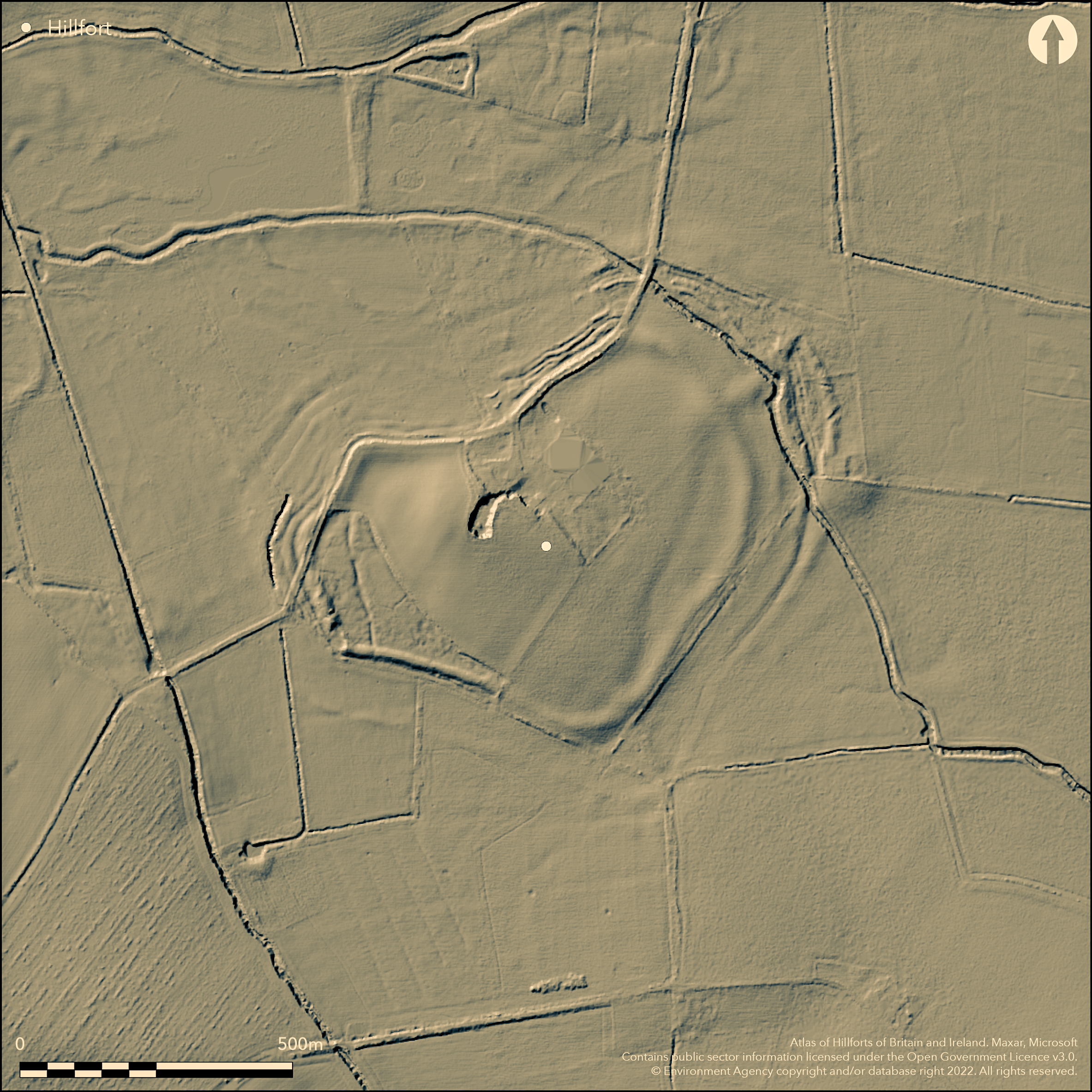
Important and large (12ha), isolated and flat, lowland marsh fort located on Tibberton Moor near to the confluence of the River Strine and River Tern and River Meese and Tern. Oval in shape, and measuring 590m N-S and 69m E-W, it was formerly located on a natural elevated island of sandstone and Boulder Clay, the fort surrounded by wetland and fen and accessed by causeways. Peat now surrounds the site, which is now barely 2m-3m above the surrounds. A rubble and Boulder Clay inner bank, with possible stone retaining walls, is almost intact, apart from where a modern road crosses the summit of the rise, but it is much ploughed and spread, averaging 2.5m wide and 1.5m high on the N. This inner rampart is surrounded by a complex of up to five close-set banks, with ditches, strongest on the NW side, where the ground is slightly higher than on the SE, up to c. 1m high now and 6m-12m wide, with evidence of considerable re-modelling. The outer bank possibly circled the perimeter, apart, it seems, to the SE, but it has long stretches where it is destroyed on the NW and W sides. These banks are all much fragmented and ploughed-down, some now buried and difficult to interpret, but would have formed a very formidable obstacle in prehistory. A particular feature of the site are the causewayed entrances. One an 8m causeway through the inner rampart at the SE corner of the site, the second a flat-topped causeway to the NE. Excavations by the Wrekin Archaeological Group in 1962-65 across the ramparts showed four periods of construction and how complex the site is, but no dating evidence. Limited excavation of the interior in 1983 (Bond 1991) close to Wall Farm, which stands in the centre of the fort, however, found circular and rectangular post-built structures, together with Iron Age pottery and VCP from the brine springs of Cheshire. C14 and pottery dating indicated occupation from the 3rd century BC to the 1st century AD, just before the Roman Conquest. Apart from Wall Farm, with its associated structures and roads, site under permanent pasture, with some scrub and trees dotted about the site. On 1st Ed OS map (1885-1900).
Citizen Science: ✗
Reliability of Data: Confirmed
Reliability of Interpretation: Confirmed
X: -275424 Y: 6938127 (EPSG: 3857)
Longitude: -2.4741749161562248 Latitude: 52.75673823908361 (EPSG:4326)
Country: England; None
Current County or Unitary Authority: Shropshire
Historic County: Shropshire
Current Parish/Community/Council/Townland: Kynnersley; Tibberton
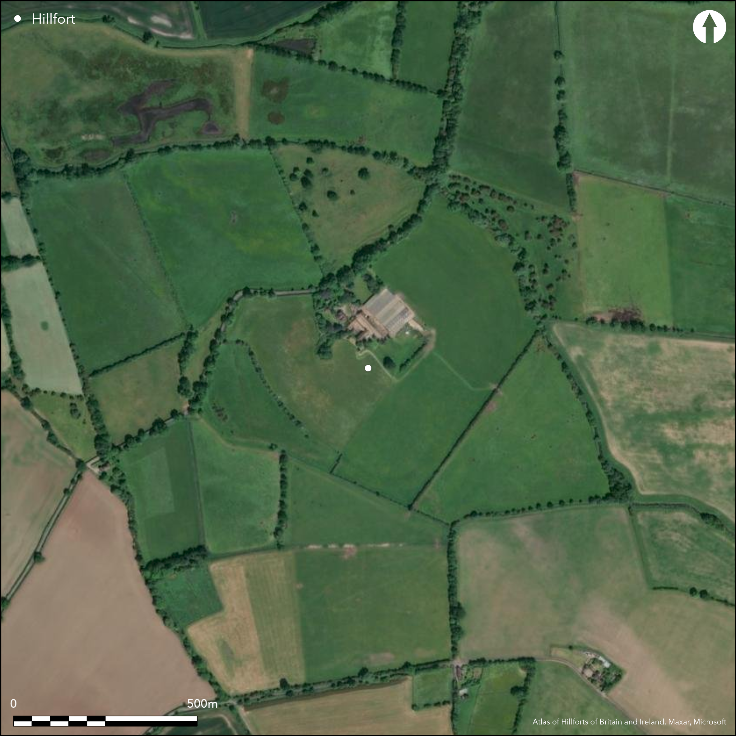
Damaged in the past with Wall Farm located in centre of the fort, with associated buildings, fences, roads etc. Now in good management.
| Extant | ✓ |
| Cropmark | ✗ |
| Likely Destroyed | ✓ |
Under permanent pasture, with some scrub and trees dotted about the site. Wall farm.
| Woodland | ✗ |
| Commercial Forestry Plantation | ✗ |
| Parkland | ✗ |
| Pasture (Grazing) | ✓ |
| Arable | ✗ |
| Scrub/Bracken | ✓ |
| Bare Outcrop | ✗ |
| Heather/Moorland | ✗ |
| Heath | ✗ |
| Built-up | ✓ |
| Coastal Grassland | ✗ |
| Other | ✗ |
Important and large (12ha), isolated and flat lowland marsh fort located on Tibberton Moor near to the confluence of the River Strine and River Tern and River Meese and Tern.
| Contour Fort | ✗ |
| Partial Contour Fort | ✗ |
| Promontory Fort | ✗ |
| Hillslope Fort | ✗ |
| Level Terrain Fort | ✗ |
| Marsh Fort | ✓ |
| Multiple Enclosure Fort | ✗ |
| Hilltop | ✗ |
| Coastal Promontory | ✗ |
| Inland Promontory | ✗ |
| Valley Bottom | ✗ |
| Knoll/Hillock/Outcrop | ✓ |
| Ridge | ✗ |
| Cliff/Plateau-edge/Scarp | ✗ |
| Hillslope | ✗ |
| Lowland | ✓ |
| Spur | ✗ |
Dominant Topographic Feature: Low lying sandstone and Boulder Clay former island in the midst of former fen.
| North | ✗ |
| Northeast | ✗ |
| East | ✗ |
| Southeast | ✗ |
| South | ✗ |
| Southwest | ✗ |
| West | ✗ |
| Northwest | ✗ |
| Level | ✓ |
Altitude: 60.0m
Boundary Type: Parish/Townland
C14 and Iron Age and VCP pottery dating indicated occupation from the 3rd century BC to the 1st century AD, just before the Roman Conquest; dating of 377 cal BC - 52 cal AD. Limited excavation of interior 1983 by D. Bond and E.L. Morris close to Wall Farm, which stands in the centre of fort, found circular and rectangular post-built structures with Iron Age pottery and VCP from brine springs of Cheshire.
Reliability: B - Medium
| Pre 1200BC | ✗ |
| 1200BC - 800BC | ✗ |
| 800BC - 400BC | ✗ |
| 400BC - AD50 | ✓ |
| AD50 - AD400 | ✗ |
| AD400 - AD 800 | ✗ |
| Post AD800 | ✗ |
| Unknown | ✗ |
| Pre Hillfort: | None |
| Post Hillfort: | None |
| Artefactual: | Iron Age and VCP pottery dating. |
| C14: | C14 and Iron Age and VCP pottery dating indicated occupation from the 3rd century BC to the 1st century AD, just before the Roman Conquest. |
On 1st Ed OS map (1885-1900). Small excavation by T.C. Cantrill in 1919 through inner rampart found clay and rubble rampart faced with stone retaining slabs. Excavations by J.A. Pagett 1962-65 of the Wrekin Archaeological Group in 1962-65. Field observation Ordnance Survey 1976. Field observations English Heritage 1979, 1980, 1981, 1987. Limited excavation of interior by D. Bond and E.L. Morris, close to Wall Farm in the centre of the fort 1983. Shropshire Council survey 2012. Geophysical survey 2008, Arch. Services Durham (available on ADS Grey Lit library, OASIS archaeol3-45534). Environmental sampling adjacent to fort 2013.
| Other (1976): | Field observation OS. |
| Other (1981): | Field observation Shropshire CC. |
| Excavation (1983): | Limited excavation of the interior in 1983 by D. Bond and E.L. Morris close to Wall Farm. |
| Geophysical Survey (2008): | ARCUS. |
| Other (2012): | Shropshire Council survey. |
| 1st Identified Map Depiction (None): | 1st Ed OS |
| Excavation (None): | Excavations by J.A. Pagett 1962-65 of the Wrekin Archaeological Group. |
| Other (None): | Field observations English Heritage. |
Limited excavation of the interior in 1983 close to Wall Farm, which stands in the centre of the fort, however, found circular and rectangular post-built structures. Iron Age pottery and VCP from the brine springs of Cheshire.
Strine Book borders site, but an abundance of water sources surrounding the site in prehistory.
| None | ✗ |
| Spring | ✗ |
| Stream | ✗ |
| Pool | ✗ |
| Flush | ✗ |
| Well | ✗ |
| Other | ✓ |
None
| No Known Features | ✓ |
| Round Stone Structures | ✗ |
| Rectangular Stone Structures | ✗ |
| Curvilinear Platforms | ✗ |
| Other Roundhouse Evidence | ✗ |
| Pits | ✗ |
| Quarry Hollows | ✗ |
| Other | ✗ |
Limited excavation of the interior in 1983 close to Wall Farm, which stands in the centre of the fort, however, found circular and rectangular post-built structures.
| No Known Excavation | ✗ |
| Pits | ✗ |
| Postholes | ✗ |
| Roundhouses | ✓ |
| Rectangular Structures | ✓ |
| Roads/Tracks | ✗ |
| Quarry Hollows | ✗ |
| Other | ✗ |
| Nothing Found | ✗ |
None
| No Known Geophysics | ✓ |
| Pits | ✗ |
| Roundhouses | ✗ |
| Rectangular Structures | ✗ |
| Roads/Tracks | ✗ |
| Quarry Hollows | ✗ |
| Other | ✗ |
| Nothing Found | ✗ |
Iron Age pottery and VCP from the brine springs of Cheshire.
| No Known Finds | ✗ |
| Pottery | ✓ |
| Metal | ✗ |
| Metalworking | ✗ |
| Human Bones | ✗ |
| Animal Bones | ✗ |
| Lithics | ✗ |
| Environmental | ✗ |
| Other | ✗ |
None
| APs Not Checked | ✓ |
| None | ✗ |
| Roundhouses | ✗ |
| Rectangular Structures | ✗ |
| Pits | ✗ |
| Postholes | ✗ |
| Roads/Tracks | ✗ |
| Other | ✗ |
A particular feature of the site are the causewayed entrances. One is an 8m causeway through the inner rampart at the SE corner of the site, the second a flat-topped causeway to the NE.
| 2: | Modern gaps probably occur but are not recorded. |
| 2: | A particular feature of the site are the causewayed entrances. One an 8m causeway through the inner rampart at the SE corner of the site, the second a flat topped causeway to the NE. |
Guard Chambers: ✗
Chevaux de Frise: ✗
| 1. Simple Gap (South east): | 8m causeway through the inner rampart corner. |
| 2. Simple Gap (North east): | Flat topped causeway. |
Rubble and Boulder Clay inner bank, with possible stone retaining walls, is almost intact, apart from where a modern road crosses the summit of the rise, but it is much ploughed and spread, averaging 2.5m wide and 1.5m high on the N. This inner rampart is surrounded by a complex of up to five close-set banks, with ditches, strongest on the NW side where the ground is slightly higher than on the SE, up to c. 1m high now and 6m-12m wide, with evidence of considerable re-modelling. The outer bank possibly circled the perimeter, apart, it seems to the SE, but it has long stretches where it is destroyed on the NW and W sides. These banks are all much fragmented and ploughed down, some now buried and difficult to interpret, but would have formed a very formidable obstacle in prehistory. The exact number of banks on each quarter is difficult to assess, but there are up to five in each quarter apart from the SE.
| Area 1: | 12.0ha. |
| Total: | 12.0ha. |
Total Footprint Area: Noneha.
None
| ✓ | Excavations by J.A. Pagett of the Wrekin Archaeological Group in 1962-65 across the defences showed four periods of construction and how complex the site is, but no dating evidence. |
| ✓ | None |
| NE Quadrant: | 5 |
| SE Quadrant: | 1 |
| SW Quadrant: | 5 |
| NW Quadrant: | 4 |
| Total: | 5 |
| Partial Univallate | ✓ |
| Univallate | ✗ |
| Partial Bivallate | ✗ |
| Bivallate | ✗ |
| Partial Multivallate | ✓ |
| Multivallate | ✗ |
| Unknown | ✗ |
| Partial Univallate | ✗ |
| Univallate | ✓ |
| Partial Bivallate | ✗ |
| Bivallate | ✗ |
| Partial Multivallate | ✗ |
| Multivallate | ✗ |
None
| None | ✗ |
| Earthen Bank | ✓ |
| Stone Wall | ✗ |
| Rubble | ✗ |
| Wall-walk | ✗ |
| Evidence of Timber | ✗ |
| Vitrification | ✗ |
| Other Burning | ✗ |
| Palisade | ✗ |
| Counter Scarp Bank | ✗ |
| Berm | ✗ |
| Unfinished | ✗ |
| Other | ✗ |
The banks are composed of rubble and Boulder Clay with stone retaining walls. Small excavation by T.C. Canrill in 1919 through inner rampart found clay and rubble rampart faced with stone retaining slabs.
| None | ✗ |
| Earthen Bank | ✓ |
| Stone Wall | ✓ |
| Murus Duplex | ✗ |
| Timber-framed | ✗ |
| Timber-laced | ✗ |
| Vitrification | ✗ |
| Other Burning | ✗ |
| Palisade | ✗ |
| Counter Scarp Bank | ✗ |
| Berm | ✗ |
| Unfinished | ✗ |
| No Known Excavation | ✗ |
| Other | ✗ |
| ✗ | None |
| ✓ | Up to five ditches, most now buried features. |
Number of Ditches: 5
| ✗ | None |
Bond, D.M. 1991. An excavation at Wall Camp, Kynnersley, Trans Shropshire Archaeol Hist Soc, 67, 98-107.
Dorling, P. and Wigley, A. 2012. Assessment of the archaeological and conservation status of major later prehistoric enclosures in Herefordshire and Shropshire, EH PNUM, Version 3.2, Hereford and Shrewsbury: Herefordshire Council/Shropshire Council.
Malim, C. 2013. The Wall. Prehistoric fort or monumental labyrinth? Brit Archaeol, May/June 2013, 33-7.
Page, W. ed. 1908. Victoria County History of Shropshire, 1, 374, Institute of Historical Research.
Atlas of Hillforts:
Wikidata:
This work is licensed under CC BY-SA 4.0![]()
![]()
![]() and should be cited as:
and should be cited as:
Lock, Gary and Ralston, Ian. 2024. Atlas of Hillforts of Britain and Ireland. Available at: https://hillforts.arch.ox.ac.uk
Document Version 1.1