LiDAR 1m DTM Hillshade
Satellite Imagery
LiDAR 1m DTM Hillshade
Satellite Imagery
Scroll left/right to view further images.
HER: Shropshire 1361 (None)
NMR: SJ 30 NW 2 (66348)
SM: 1021277
NGR: SJ 300057
X: 330055 Y: 305729 (OSGB36)
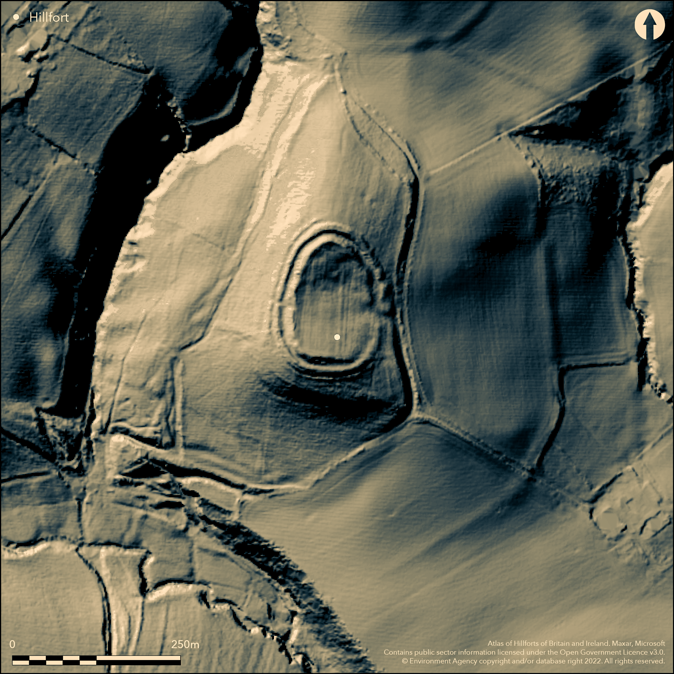
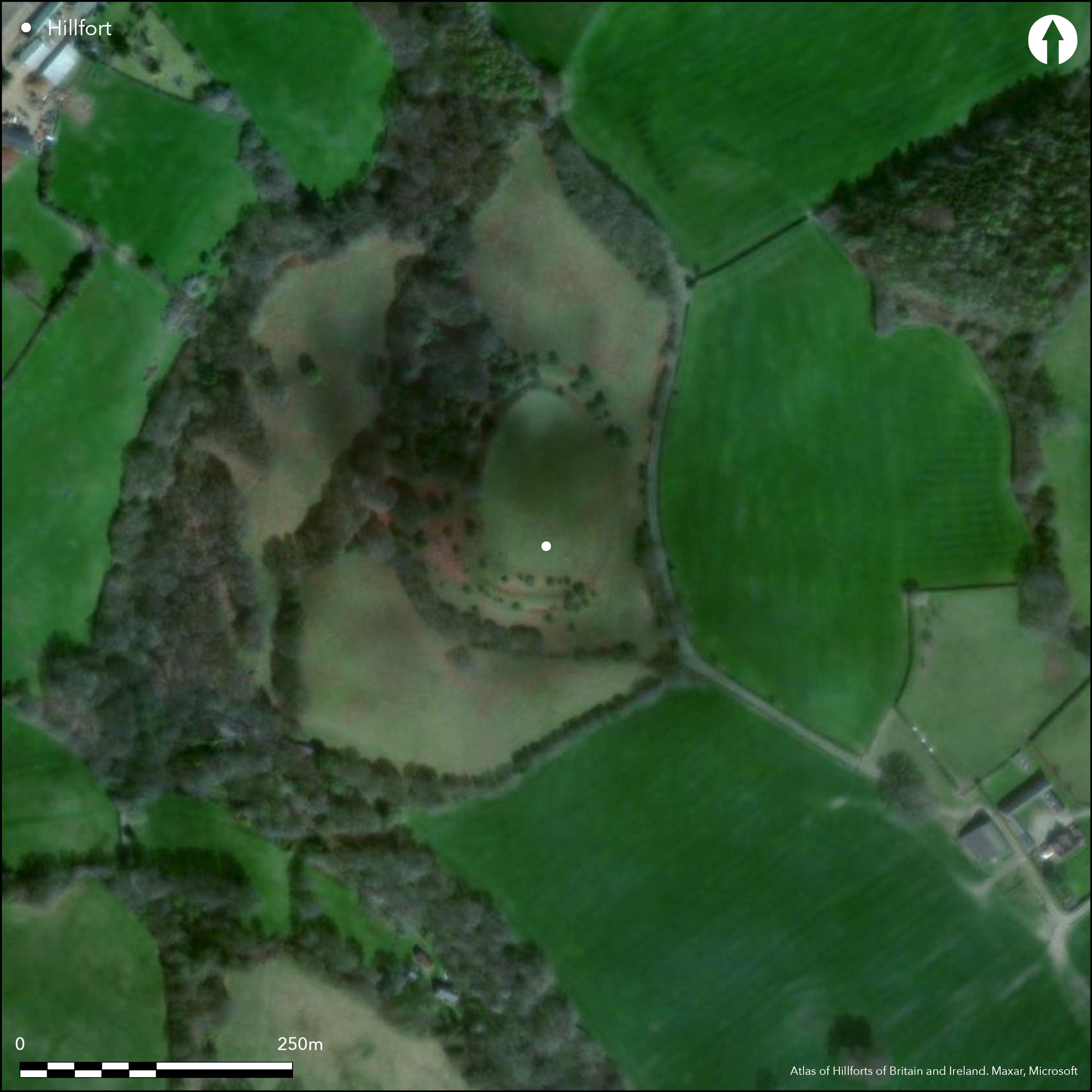
Isolated, bivallate, partial contour fort sited at the S end of a knoll/spur overlooking the valley of the Rea Brook to the S and SW and Rowley Brook and uplands beyond. Commanding site only overlooked from a distance. The site is egg-shaped with the apex to the N. measuring 95 m by 65 m, enclosing 0.44ha. Two lines of bank and ditch have a counterscarp bank on the W and NW sides. In the SE sector the rampart is spread and reduced to only a scarp. There is an inturned entrance on the E with a pronounced holloway leading S 90m long and 8m in width and 1m deep to the E, and turns W before petering out, but could have continued for another 70m to the SW. A geophysical survey of 1999, although being generally inconclusive, found remnants of the inner bank in several places in the interior. No surface features are visible in the interior. The site is under long-standing pasture with some local stock erosion. Ridge and furrow in the interior. The site was only scheduled in 2004. On 1st Ed OS map (1899). Undated.
Citizen Science: ✗
Reliability of Data: Confirmed
Reliability of Interpretation: Confirmed
X: -337880 Y: 6917554 (EPSG: 3857)
Longitude: -3.035224386064255 Latitude: 52.64474693094868 (EPSG:4326)
Country: England
Current County or Unitary Authority: Shropshire
Historic County: Shropshire
Current Parish/Community/Council/Townland: Worthen with Shelve
Stock erosion on inner W rampart and open scrub on ramparts.
| Extant | ✓ |
| Cropmark | ✗ |
| Likely Destroyed | ✗ |
Long managed under unimproved pasture
| Woodland | ✗ |
| Commercial Forestry Plantation | ✗ |
| Parkland | ✗ |
| Pasture (Grazing) | ✓ |
| Arable | ✗ |
| Scrub/Bracken | ✓ |
| Bare Outcrop | ✗ |
| Heather/Moorland | ✗ |
| Heath | ✗ |
| Built-up | ✗ |
| Coastal Grassland | ✗ |
| Other | ✗ |
Interior slopes from N to S. Sited on a the S end of an isolated knoll/ spur overlooking the valley of the Rea Brook to S and SW and Rowley Brook and uplands beyond..
| Contour Fort | ✗ |
| Partial Contour Fort | ✓ |
| Promontory Fort | ✗ |
| Hillslope Fort | ✗ |
| Level Terrain Fort | ✗ |
| Marsh Fort | ✗ |
| Multiple Enclosure Fort | ✗ |
| Hilltop | ✗ |
| Coastal Promontory | ✗ |
| Inland Promontory | ✗ |
| Valley Bottom | ✗ |
| Knoll/Hillock/Outcrop | ✓ |
| Ridge | ✗ |
| Cliff/Plateau-edge/Scarp | ✗ |
| Hillslope | ✗ |
| Lowland | ✗ |
| Spur | ✓ |
Dominant Topographic Feature: Isolated knoll/spur.
| North | ✗ |
| Northeast | ✗ |
| East | ✗ |
| Southeast | ✗ |
| South | ✓ |
| Southwest | ✗ |
| West | ✗ |
| Northwest | ✗ |
| Level | ✗ |
Altitude: 229.0m
N/A
None
Reliability: D - None
| Pre 1200BC | ✗ |
| 1200BC - 800BC | ✗ |
| 800BC - 400BC | ✗ |
| 400BC - AD50 | ✗ |
| AD50 - AD400 | ✗ |
| AD400 - AD 800 | ✗ |
| Post AD800 | ✗ |
| Unknown | ✗ |
| Pre Hillfort: | None |
| Post Hillfort: | None |
On 1st Ed OS map (1899). Field observation Ordnance Survey 1971. Field observation Shropshire CC 1981. Geophysical survey University of Sheffield 1999. Shropshire Council survey 2012.
| 1st Identified Map Depiction (1899): | None |
| Other (1971): | Field observation OS. |
| Other (1981): | Field observation Shropshire CC. |
| Geophysical Survey (1999): | University of Sheffield. |
| Other (2012): | Shropshire Council survey. |
A geophysical survey of 1999, although being generally inconclusive, found remnants of the inner bank in several places in the interior.
Stream located 0.15km outside the fort.
| None | ✓ |
| Spring | ✗ |
| Stream | ✗ |
| Pool | ✗ |
| Flush | ✗ |
| Well | ✗ |
| Other | ✗ |
None
| No Known Features | ✓ |
| Round Stone Structures | ✗ |
| Rectangular Stone Structures | ✗ |
| Curvilinear Platforms | ✗ |
| Other Roundhouse Evidence | ✗ |
| Pits | ✗ |
| Quarry Hollows | ✗ |
| Other | ✗ |
None
| No Known Excavation | ✓ |
| Pits | ✗ |
| Postholes | ✗ |
| Roundhouses | ✗ |
| Rectangular Structures | ✗ |
| Roads/Tracks | ✗ |
| Quarry Hollows | ✗ |
| Other | ✗ |
| Nothing Found | ✗ |
A geophysical survey of 1999, although being generally inconclusive, found remnants of the inner bank in several places in the interior.
| No Known Geophysics | ✗ |
| Pits | ✗ |
| Roundhouses | ✗ |
| Rectangular Structures | ✗ |
| Roads/Tracks | ✗ |
| Quarry Hollows | ✗ |
| Other | ✓ |
| Nothing Found | ✗ |
None
| No Known Finds | ✓ |
| Pottery | ✗ |
| Metal | ✗ |
| Metalworking | ✗ |
| Human Bones | ✗ |
| Animal Bones | ✗ |
| Lithics | ✗ |
| Environmental | ✗ |
| Other | ✗ |
None
| APs Not Checked | ✓ |
| None | ✗ |
| Roundhouses | ✗ |
| Rectangular Structures | ✗ |
| Pits | ✗ |
| Postholes | ✗ |
| Roads/Tracks | ✗ |
| Other | ✗ |
There is an inturned entrance on the E with a pronounced holloway leading S 90 m long and 8 m in width and 1.5 m deep to the E, and turns W before petering out, but could have continued for another 70 m to the SW.
| 1: | No modern gaps. |
| 2: | Inturned entrance on the E original. |
Guard Chambers: ✗
Chevaux de Frise: ✗
| 1. In-turned (East): | There is an inturned entrance on the E with a pronounced holloway leading S 90m long and 8m in width and 1.5 m deep to the E, and turns W before petering out, but could have continued for another 70m to the SW. |
| 1. Hollow Way (East): | Pronounced hollow way. |
Two lines of bank and ditch have a counterscarp bank on the W and NW sides. In the SE sector the rampart is spread and reduced to only a scarp. Geophysical survey of 1999, although being generally inconclusive, found remnants of the inner bank in several places in the interior.
| Area 1: | 0.44ha. |
| Total: | 0.44ha. |
Total Footprint Area: Noneha.
None
| ✗ | None |
| ✓ | Good circuit of two ramparts plus counterscarp bank to W and NW. |
| NE Quadrant: | 2 |
| SE Quadrant: | 2 |
| SW Quadrant: | 2 |
| NW Quadrant: | 2 |
| Total: | 2 |
| Partial Univallate | ✗ |
| Univallate | ✗ |
| Partial Bivallate | ✗ |
| Bivallate | ✓ |
| Partial Multivallate | ✗ |
| Multivallate | ✗ |
| Unknown | ✗ |
| Partial Univallate | ✗ |
| Univallate | ✗ |
| Partial Bivallate | ✗ |
| Bivallate | ✗ |
| Partial Multivallate | ✗ |
| Multivallate | ✗ |
Counterscarp bank to the W and NW.
| None | ✗ |
| Earthen Bank | ✓ |
| Stone Wall | ✗ |
| Rubble | ✗ |
| Wall-walk | ✗ |
| Evidence of Timber | ✗ |
| Vitrification | ✗ |
| Other Burning | ✗ |
| Palisade | ✗ |
| Counter Scarp Bank | ✓ |
| Berm | ✗ |
| Unfinished | ✗ |
| Other | ✗ |
None
| None | ✗ |
| Earthen Bank | ✗ |
| Stone Wall | ✗ |
| Murus Duplex | ✗ |
| Timber-framed | ✗ |
| Timber-laced | ✗ |
| Vitrification | ✗ |
| Other Burning | ✗ |
| Palisade | ✗ |
| Counter Scarp Bank | ✗ |
| Berm | ✗ |
| Unfinished | ✗ |
| No Known Excavation | ✓ |
| Other | ✗ |
| ✗ | None |
| ✓ | Ditches surround the site. |
Number of Ditches: 2
| ✗ | None |
Dorling, P. and Wigley, A. 2012: Assessment of the archaeological and conservation status of major later prehistoric enclosures in Herefordshire and Shropshire, EH PNUM, Version 3.2, Hereford and Shrewsbury: Herefordshire Council/Shropshire Council.
Page, W. ed. 1908. Victoria County History of Shropshire, 1, 370, Institute of Historical Research.
Atlas of Hillforts:
Wikidata:
This work is licensed under CC BY-SA 4.0![]()
![]()
![]() and should be cited as:
and should be cited as:
Lock, Gary and Ralston, Ian. 2024. Atlas of Hillforts of Britain and Ireland. Available at: https://hillforts.arch.ox.ac.uk
Document Version 1.1