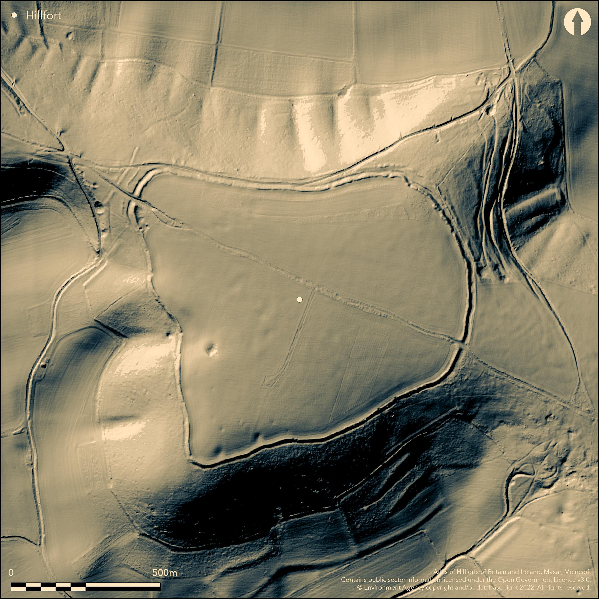
LiDAR 1m DTM Hillshade

Satellite Imagery
LiDAR 1m DTM Hillshade
Satellite Imagery
Scroll left/right to view further images.
HER: West Berkshire MWB1578 (None)
NMR: SU 36 SE 5 (228800)
SM: 1005387
NGR: SU 37408 61800
X: 437408 Y: 161800 (OSGB36)
On the highest part of the Downs between West Berkshire and Hampshire and to the E of Combe Gibbet, a large, trapezoidal, univallate hillfort of 33ha. It is located at the widening of an EW chalk ridge and is the largest hillfort in the former county of Berkshire. An outer bank cuts across the spur in the NE and traces of counterscarp banks occur in places. Slight banks extend from the NW entrance as 'barbican-like' features (Payne 2006:45). The main entrance lies in the N-W with a further entrance in the SE which is considered to be original based on the widening of the ditches. A gap with staggered entrance in the outer bank might also be original. Beyond these In the W, a further 120m length of ditch cuts across the ridge. Both are associated with a hollow way. The presence of internal features is unknown and no excavation has taken place. A magnetometry survey produced a large number of anomalies, only a small number of which were possibly archaeological but would require excavation to confirm (Payne 2006: 47). Because of the large area enclosed, slight enclosing works and lack of evidence for intensive activity it has been classified by Cunliffe (2002: 380) as an 'early hill-top enclosure' with a pastoral function. The monument survives in good condition but is undated other than by morphology. The earliest known reference is in Camden's Britannia c.1586. Recorded on Ordnance Survey drawing of Hungerford 1808.
Citizen Science: ✗
Reliability of Data: Confirmed
Reliability of Interpretation: Confirmed
X: -162994 Y: 6684152 (EPSG: 3857)
Longitude: -1.4642009978529946 Latitude: 51.353995723822806 (EPSG:4326)
Country: England; None
Current County or Unitary Authority: West Berkshire
Historic County: Berkshire; Hampshire
Current Parish/Community/Council/Townland: Combe; Inkpen
None
| Extant | ✓ |
| Cropmark | ✗ |
| Likely Destroyed | ✗ |
Grassland with semi-improved grassland in the northern sector
| Woodland | ✗ |
| Commercial Forestry Plantation | ✗ |
| Parkland | ✗ |
| Pasture (Grazing) | ✗ |
| Arable | ✗ |
| Scrub/Bracken | ✗ |
| Bare Outcrop | ✗ |
| Heather/Moorland | ✗ |
| Heath | ✗ |
| Built-up | ✗ |
| Coastal Grassland | ✗ |
| Other | ✓ |
A univallate contour hiilfort lying on Cretaceous Upper Chalk overlain by calcareous silty soils of the Andover 1 series. The hillfort lies at 295m OD on the highest point on the chalk in Britain. The hillforts of Fosbury, Beacon Hill and Ladle Hill can be seen. Farther afield, both Danebury and Quarley Hill are visible to the S. Under optimum conditions Uffington Castle, Rams Hill and Segsbury can be made out on the northern horizon
| Contour Fort | ✓ |
| Partial Contour Fort | ✗ |
| Promontory Fort | ✗ |
| Hillslope Fort | ✗ |
| Level Terrain Fort | ✗ |
| Marsh Fort | ✗ |
| Multiple Enclosure Fort | ✗ |
| Hilltop | ✗ |
| Coastal Promontory | ✗ |
| Inland Promontory | ✗ |
| Valley Bottom | ✗ |
| Knoll/Hillock/Outcrop | ✗ |
| Ridge | ✓ |
| Cliff/Plateau-edge/Scarp | ✓ |
| Hillslope | ✗ |
| Lowland | ✗ |
| Spur | ✗ |
Dominant Topographic Feature: Situated at the widening of an EW chalk ridge with extensive views in all directions
| North | ✗ |
| Northeast | ✗ |
| East | ✗ |
| Southeast | ✗ |
| South | ✗ |
| Southwest | ✗ |
| West | ✗ |
| Northwest | ✗ |
| Level | ✓ |
Altitude: 295.0m
Formerly bisected by the historic counties of Berkshire and Hampshire. Now in West Berkshire, it crosses two parishes, Combe and Inkpen, although the scheduling record mentions a third parish, that of West Woodhay. The Inkpen or North Hampshire Ridgeway follows the same line, bisecting the hillfort.
Boundary Type: Parish/Townland
Undated. The site has been classified by Cunliffe (2002: 380) as an early hilltop enclosure owing to the size of enclosed area and slightness of the defences.
Reliability: C - Low
| Pre 1200BC | ✗ |
| 1200BC - 800BC | ✓ |
| 800BC - 400BC | ✓ |
| 400BC - AD50 | ✓ |
| AD50 - AD400 | ✗ |
| AD400 - AD 800 | ✗ |
| Post AD800 | ✗ |
| Unknown | ✗ |
| Pre Hillfort: | None |
| Post Hillfort: | None |
| Morphology/Earthwork/Typology: | None |
No authorised excavation has been carried out. A short-lived unauthorised schoolboy excavation of a pit was made by O.G.S. Crawford where charcoal, animal bones and two teeth were recovered. A sketch plan of a survey appears in Williams-Freeman (1915: 114). Field investigation in 1963. Geophysical survey (18.8ha) within the interior as part of the Wessex Hillfort Project (Payne et al. 2006) found no obvious archaeological features and the hillfort possibly saw only low level activity. The site is mentioned in Camden's Britannia c.1586 and Aubrey's Monumenta Britannica (1665-1693). Scheduled
| 1st Identified Written Reference (1586): | Camden's Britannia |
| 1st Identified Map Depiction (1808): | Ordnance Survey Drawing of Hungerford; BL OSD, Two inch to the mile |
| Other (1963): | Field investigation |
| Geophysical Survey (1997): | Wessex Hillforts Project |
| Excavation (None): | O.G.S Crawford pit inside 'north' entrance |
| Other (None): | Scheduled |
No surface features are visible although a pit was briefly excavated by Crawford in 1907
Alleged dew pond within the interior, possibly originating from a chalk pit, said to never run dry
| None | ✗ |
| Spring | ✗ |
| Stream | ✗ |
| Pool | ✓ |
| Flush | ✗ |
| Well | ✗ |
| Other | ✓ |
Pits in the western sector appear to be the result of chalk digging. The interior of the hillfort has been extensively cultivated.
| No Known Features | ✗ |
| Round Stone Structures | ✗ |
| Rectangular Stone Structures | ✗ |
| Curvilinear Platforms | ✗ |
| Other Roundhouse Evidence | ✗ |
| Pits | ✗ |
| Quarry Hollows | ✗ |
| Other | ✓ |
Small pit briefly excavated by O.G.S. Crawford
| No Known Excavation | ✗ |
| Pits | ✓ |
| Postholes | ✗ |
| Roundhouses | ✗ |
| Rectangular Structures | ✗ |
| Roads/Tracks | ✗ |
| Quarry Hollows | ✗ |
| Other | ✗ |
| Nothing Found | ✗ |
In the region of 60 percent of the hillfort interior has been surveyed (Payne, 2006: 44-7). Very few archaeological features could be identified and it is thought that the underlying geology rendered the survey difficult to analyse, although it was also suggested that the hillfort saw only low-level activity.
| No Known Geophysics | ✗ |
| Pits | ✗ |
| Roundhouses | ✗ |
| Rectangular Structures | ✗ |
| Roads/Tracks | ✗ |
| Quarry Hollows | ✗ |
| Other | ✓ |
| Nothing Found | ✗ |
Neolithic flint implements have been found on the surface. A Late Bronze Age globular urn is recorded as coming from the site. Charcoal, animal bones and teeth from pit.
| No Known Finds | ✗ |
| Pottery | ✓ |
| Metal | ✗ |
| Metalworking | ✗ |
| Human Bones | ✗ |
| Animal Bones | ✓ |
| Lithics | ✓ |
| Environmental | ✓ |
| Other | ✗ |
None
| APs Not Checked | ✓ |
| None | ✗ |
| Roundhouses | ✗ |
| Rectangular Structures | ✗ |
| Pits | ✗ |
| Postholes | ✗ |
| Roads/Tracks | ✗ |
| Other | ✗ |
Seven breaks, two original. In-turned to NW and simple gap to SE
| 7: | Based on earthwork plan in the Wessex Hillforts Project report (2006). |
| 2: | None |
Guard Chambers: ✗
Chevaux de Frise: ✗
| 1. In-turned (North west): | None |
| 2. Simple Gap (South east): | None |
Univallate with a steep outward facing scarp and slight outer ditch. Traces of a counterscarp bank in places. The top of the rampart in the N is approximately 5m above the ditch bottom. Slight banks extend from the NW entrance as 'barbican-like' features (Payne 2006:45). Beyond these In the W a further 120m length of ditch cuts across the ridge. Both are associated with a hollow way.
| Area 1: | 33.0ha. |
| Total: | 33.0ha. |
Total Footprint Area: 33.2ha.
Univallate with a steep outward facing scarp and slight outer ditch. In places there are traces of a counterscarp bank. The top of the rampart on the north side is approximately 5m above the ditch bottom. Slight banks extend from the north-west entrance as 'barbican-like' features (Payne 2006:45). Beyond these In the west a further 120 m length of ditch cuts across the ridge. Both are associated with a holloway.
| ✗ | None |
| ✓ | None |
| NE Quadrant: | 1 |
| SE Quadrant: | 1 |
| SW Quadrant: | 1 |
| NW Quadrant: | 1 |
| Total: | 1 |
| Partial Univallate | ✗ |
| Univallate | ✓ |
| Partial Bivallate | ✗ |
| Bivallate | ✗ |
| Partial Multivallate | ✗ |
| Multivallate | ✗ |
| Unknown | ✗ |
| Partial Univallate | ✗ |
| Univallate | ✗ |
| Partial Bivallate | ✗ |
| Bivallate | ✗ |
| Partial Multivallate | ✗ |
| Multivallate | ✗ |
Counterscarp visible in places.
| None | ✗ |
| Earthen Bank | ✓ |
| Stone Wall | ✗ |
| Rubble | ✗ |
| Wall-walk | ✗ |
| Evidence of Timber | ✗ |
| Vitrification | ✗ |
| Other Burning | ✗ |
| Palisade | ✗ |
| Counter Scarp Bank | ✓ |
| Berm | ✗ |
| Unfinished | ✗ |
| Other | ✗ |
None
| None | ✗ |
| Earthen Bank | ✗ |
| Stone Wall | ✗ |
| Murus Duplex | ✗ |
| Timber-framed | ✗ |
| Timber-laced | ✗ |
| Vitrification | ✗ |
| Other Burning | ✗ |
| Palisade | ✗ |
| Counter Scarp Bank | ✗ |
| Berm | ✗ |
| Unfinished | ✗ |
| No Known Excavation | ✓ |
| Other | ✗ |
| ✗ | None |
| ✓ | None |
Number of Ditches: 1
| ✗ | None |
William-Freeman J.P. 1915: An Introduction to Field Archaeology as Illustrated by Hampshire. Monograph
Payne, A., Corney, M. and Cunliffe B 2006: The Wessex Hillforts Project. Extensive Survey of Hillforts in Central Southern England. English Heritage, 44-47.
Metcalf, D. M. 1974. Sceattas Found at the Iron-Age Hill Fort of Walbury Camp, Berkshire. British Numis J 44, 1-12
Stevens, J. 1888. A Parochial History of St. Mary Bourne. Whiting & Company
Cunliffe, B. 2002. Iron Age Communities in Britain. 4th edition. Routledge
Atlas of Hillforts:
Wikidata:
This work is licensed under CC BY-SA 4.0![]()
![]()
![]() and should be cited as:
and should be cited as:
Lock, Gary and Ralston, Ian. 2024. Atlas of Hillforts of Britain and Ireland. Available at: https://hillforts.arch.ox.ac.uk
Document Version 1.1