LiDAR 1m DTM Hillshade
Satellite Imagery
LiDAR 1m DTM Hillshade
Satellite Imagery
Scroll left/right to view further images.
HER: West Berkshire MWB1453 (None)
NMR: SU 57 NW 4 (237273)
SM: 1006973
NGR: SU 52052 77966
X: 452052 Y: 177966 (OSGB36)
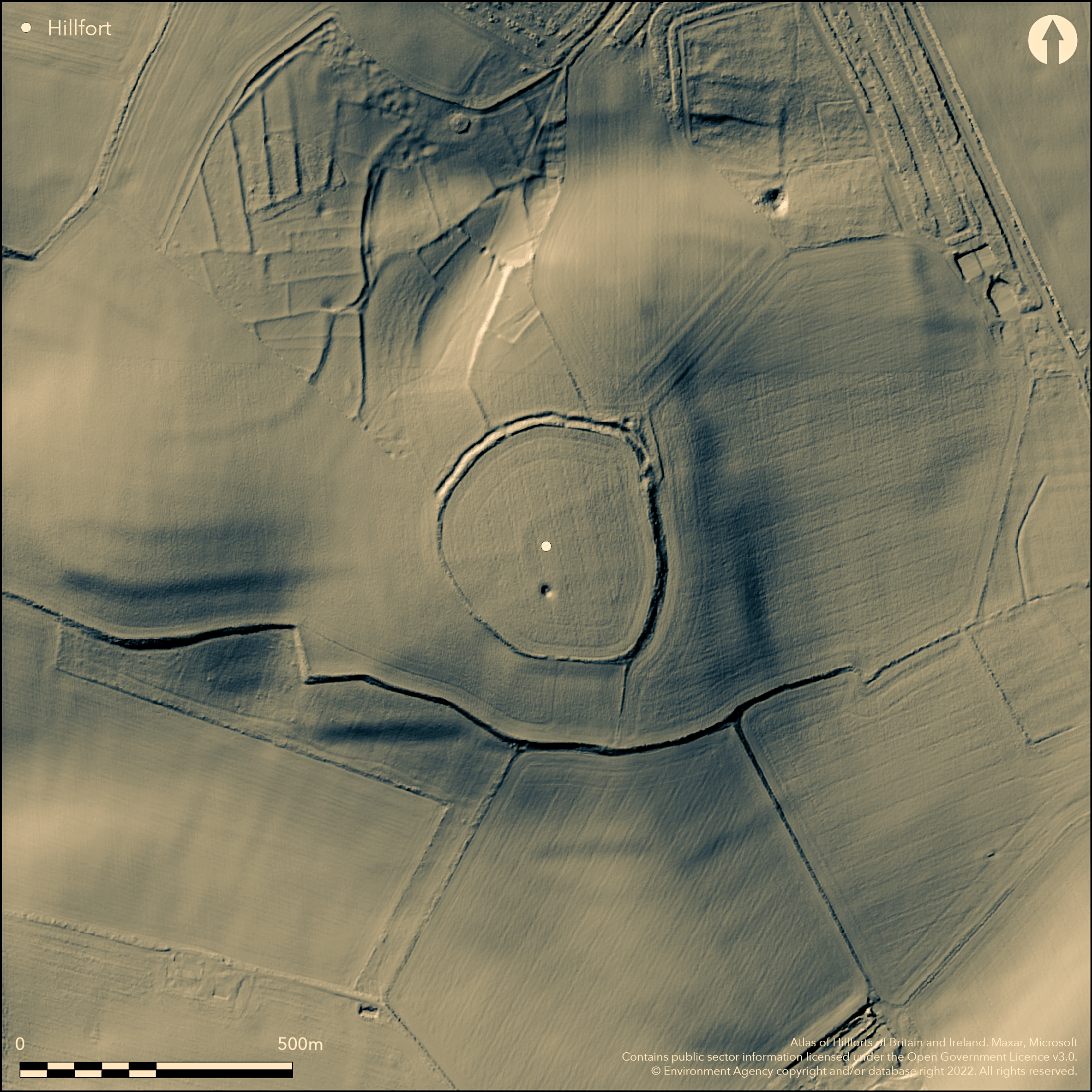
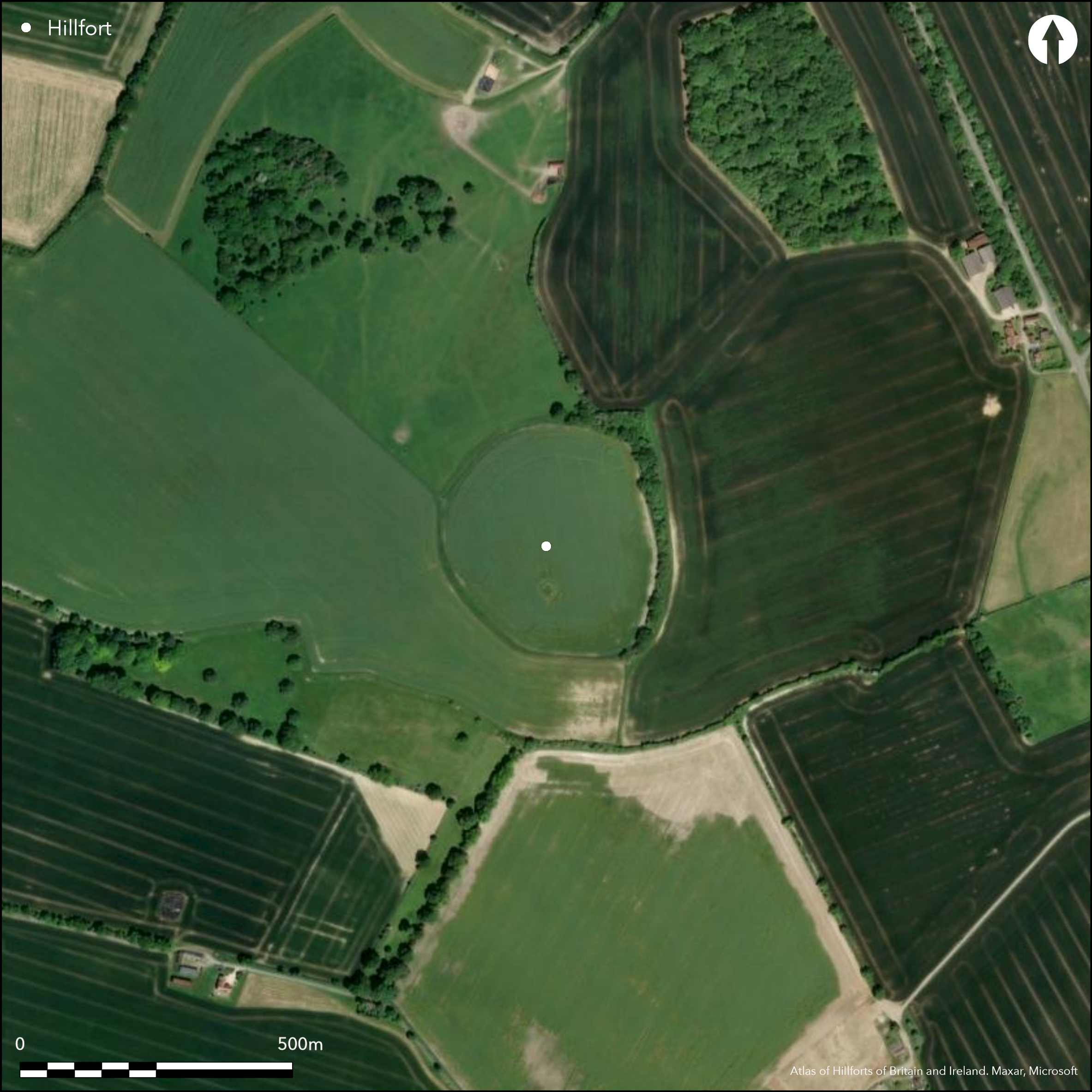
On Cow Down, Compton, an almost circular univallate hillfort of approximately 6ha located on a SE facing spur overlooking the upper reaches of the River Pang. Deep ploughed since World War II and until recent times, the ramparts are now ploughed-down except in the N but the form of the hillfort is preserved in the field boundaries. On the northern side they consist of a bank, ditch, and possible counterscarp. The only known contemporary entrance lies in the N. The presence of features within the interior is unknown. The interior underwent a geophysical survey as part of the Wessex Hillforts Project (Payne et al. 2006) which showed little evidence for intensive or prolonged settlement, but signals from the area of the bank and the fill of the ditch suggested the presence of a considerable quantity of burnt material. Pottery sherds of a 6th-5th century date were recovered from ploughsoil within the interior in the 1930's and 60's but the site is unexcavated and otherwise undated. Immediately to the N are extensive remains of coaxial field systems. Recorded on the 1808 OS East Ilsley drawing.
Citizen Science: ✗
Reliability of Data: Confirmed
Reliability of Interpretation: Confirmed
X: -139322 Y: 6709896 (EPSG: 3857)
Longitude: -1.2515492013768634 Latitude: 51.4981938089108 (EPSG:4326)
Country: England; None
Current County or Unitary Authority: West Berkshire
Historic County: Berkshire
Current Parish/Community/Council/Townland: Compton; Hampstead Norreys
Upstanding but almost destroyed. Best preserved in the N where it lies in unploughed grassland.
| Extant | ✓ |
| Cropmark | ✗ |
| Likely Destroyed | ✗ |
None
| Woodland | ✗ |
| Commercial Forestry Plantation | ✗ |
| Parkland | ✗ |
| Pasture (Grazing) | ✗ |
| Arable | ✓ |
| Scrub/Bracken | ✗ |
| Bare Outcrop | ✗ |
| Heather/Moorland | ✗ |
| Heath | ✗ |
| Built-up | ✗ |
| Coastal Grassland | ✗ |
| Other | ✓ |
A contour fort lying at 137m OD on an E-facing spur overlooking the upper reaches of the River Pang. Wood & Hardy (1962: 53) noted that its position overlooked two early routeways. The first leading to the Pang Valley-Churn gap which breaches the main escarpment of the Downs towards the Vale of the White Horse, and the 'West Ridgeway' which runs between the Thames crossings near Streatley and the Kennet crossing near Newbury.
| Contour Fort | ✓ |
| Partial Contour Fort | ✗ |
| Promontory Fort | ✗ |
| Hillslope Fort | ✗ |
| Level Terrain Fort | ✗ |
| Marsh Fort | ✗ |
| Multiple Enclosure Fort | ✗ |
| Hilltop | ✗ |
| Coastal Promontory | ✗ |
| Inland Promontory | ✗ |
| Valley Bottom | ✗ |
| Knoll/Hillock/Outcrop | ✗ |
| Ridge | ✗ |
| Cliff/Plateau-edge/Scarp | ✗ |
| Hillslope | ✗ |
| Lowland | ✗ |
| Spur | ✓ |
Dominant Topographic Feature: On the E-facing side of a spur
| North | ✗ |
| Northeast | ✗ |
| East | ✗ |
| Southeast | ✗ |
| South | ✗ |
| Southwest | ✗ |
| West | ✗ |
| Northwest | ✗ |
| Level | ✓ |
Altitude: 137.0m
Parish boundary between Compton and Hampstead Norreys runs to the S of the hillfort
Boundary Type: Parish/Townland
Surface finds of pottery suggests an early Iron Age 6th-5th century date, falling out of use by the middle Iron Age.
Reliability: C - Low
| Pre 1200BC | ✗ |
| 1200BC - 800BC | ✗ |
| 800BC - 400BC | ✓ |
| 400BC - AD50 | ✓ |
| AD50 - AD400 | ✗ |
| AD400 - AD 800 | ✗ |
| Post AD800 | ✗ |
| Unknown | ✗ |
| Pre Hillfort: | None |
| Post Hillfort: | None |
| Artefactual: | None |
On 1808 Ordnance Survey drawing of East Ilsley, General reference in Gray (1839). Earthwork survey 1961-2 (Wood and Harding 1962), Field investigation 1964. Geophysical survey 1996 (Payne et al. 2006). Scheduled
| 1st Identified Map Depiction (1808): | Shown as Compton Castle on East Ilsley drawing, BL OSD 158, 2 inch to the mile |
| 1st Identified Written Reference (1839): | None |
| Other (1964): | Field investigation |
| Geophysical Survey (1996): | Wessex Hillforts Project (Payne et al. 2006) |
| Earthwork Survey (None): | Reading University (Wood and Harding 1962) |
| Other (None): | Scheduled |
The interior was deep ploughed during World War II and there is no surface evidence for intensive settlement. 32 sherds of Early Iron Age Pottery were recovered from plough soil in the 1930s; a few more were recovered in the 1960s. Possible quarry hollows. Pits shown by geophysical survey.
None
| None | ✓ |
| Spring | ✗ |
| Stream | ✗ |
| Pool | ✗ |
| Flush | ✗ |
| Well | ✗ |
| Other | ✗ |
Five circular hollows are probably marl pits.
| No Known Features | ✗ |
| Round Stone Structures | ✗ |
| Rectangular Stone Structures | ✗ |
| Curvilinear Platforms | ✗ |
| Other Roundhouse Evidence | ✗ |
| Pits | ✗ |
| Quarry Hollows | ✓ |
| Other | ✗ |
None
| No Known Excavation | ✓ |
| Pits | ✗ |
| Postholes | ✗ |
| Roundhouses | ✗ |
| Rectangular Structures | ✗ |
| Roads/Tracks | ✗ |
| Quarry Hollows | ✗ |
| Other | ✗ |
| Nothing Found | ✗ |
Approximately 100 positive anomolies suggest probable pits and lengths and ditch. The density and clustering of pits is similar to tthat seen at other local hillforts where occupation was short-lived and restricted to the early Iron Age (Payne et al. 2006)
| No Known Geophysics | ✗ |
| Pits | ✓ |
| Roundhouses | ✗ |
| Rectangular Structures | ✗ |
| Roads/Tracks | ✗ |
| Quarry Hollows | ✗ |
| Other | ✗ |
| Nothing Found | ✗ |
32 sherds of Early Iron Age Pottery were recovered from plough soil in the 1930s; a few more were recovered in the 1960s.
| No Known Finds | ✗ |
| Pottery | ✓ |
| Metal | ✗ |
| Metalworking | ✓ |
| Human Bones | ✗ |
| Animal Bones | ✗ |
| Lithics | ✗ |
| Environmental | ✗ |
| Other | ✗ |
None
| APs Not Checked | ✓ |
| None | ✗ |
| Roundhouses | ✗ |
| Rectangular Structures | ✗ |
| Pits | ✗ |
| Postholes | ✗ |
| Roads/Tracks | ✗ |
| Other | ✗ |
A simple gap entrance in the N
| None: | None |
| 2: | None |
Guard Chambers: ✗
Chevaux de Frise: ✗
| 1. Simple Gap (North): | None |
A nearly circular ditch between two banks; the outer bank possibly a counterscarp. The defences around the southern and western sides of the site have been largely ploughed out. On the northern side the defences consist of a bank, ditch, and possible counterscarp. Gray (1839) reported that a farmer had dug up several loads of great sarsen stones that had been laid regularly over a layer of flints. Augering had indicated that similar stones may have been present along part of the bank. Gray also reported that some sarsens from the site were broken up and used to repair roads. Possible gang working.
| Area 1: | 5.7ha. |
| Total: | 5.7ha. |
Total Footprint Area: 6.0ha.
None
| ✗ | Wood & Hardy (1962:55) noted the presence of a large sarsen stone near the south west perimeter and speculated that the ramparts, might have been faced with sarsens. |
| ✗ | A nearly circular ditch between two banks; the outer bank may be a counterscarp.The defences around the southern and western sides of the site have been largely ploughed out. On the northern side the defences consist of a bank, ditch, and possible counterscarp. |
| NE Quadrant: | 1 |
| SE Quadrant: | 0 |
| SW Quadrant: | 0 |
| NW Quadrant: | 1 |
| Total: | 1 |
| Partial Univallate | ✓ |
| Univallate | ✗ |
| Partial Bivallate | ✗ |
| Bivallate | ✗ |
| Partial Multivallate | ✗ |
| Multivallate | ✗ |
| Unknown | ✗ |
| Partial Univallate | ✗ |
| Univallate | ✗ |
| Partial Bivallate | ✗ |
| Bivallate | ✗ |
| Partial Multivallate | ✗ |
| Multivallate | ✗ |
Magnetic signals from the area of the bank and the fill of the ditch were high suggesting the presence of a considerable quantity of burnt material. (Payne et al. 2006, 44). Across the bank it was observed that the magnetic signal was double peaked, possibly indicating the presence of discrete parallel structures within the ramparts. It is suggested that the rampart defences may have been burnt.
| None | ✗ |
| Earthen Bank | ✗ |
| Stone Wall | ✗ |
| Rubble | ✗ |
| Wall-walk | ✗ |
| Evidence of Timber | ✗ |
| Vitrification | ✓ |
| Other Burning | ✓ |
| Palisade | ✗ |
| Counter Scarp Bank | ✓ |
| Berm | ✗ |
| Unfinished | ✗ |
| Other | ✗ |
None
| None | ✗ |
| Earthen Bank | ✗ |
| Stone Wall | ✗ |
| Murus Duplex | ✗ |
| Timber-framed | ✗ |
| Timber-laced | ✗ |
| Vitrification | ✗ |
| Other Burning | ✗ |
| Palisade | ✗ |
| Counter Scarp Bank | ✗ |
| Berm | ✗ |
| Unfinished | ✗ |
| No Known Excavation | ✓ |
| Other | ✗ |
| ✓ | Enclosing banks appear to have been created from a series of straight lengths with angular changes in alignment and possibly dictated by the overlying adjacent field systems. |
| ✓ | None |
Number of Ditches: 1
| ✗ | None |
Cotton, M.A. 1962, Berkshire Hillforts, Berkshire Archaeol J., vol. 60, pp. 30-52
Gray, E. 1839. The History and Antiquities of Newbury and Its Environs: Including Twenty-eight Parishes, Situate in the County of Berks., Hall and Marsh.
Hewett, W. 1844. The History & Antiquities of the Hundred of Compton, Berks., John Snare.
Page, W. 1906. The Victoria History of the Counties of England: Berkshire, London: Constable.
Payne, A., Corney, M. and Cunliffe, B.W. 2006, Wessex Hillforts Project - extensive survey of hillfort interiors in central southern England. London: English Heritage, 39-44
Underhill, F.M. 1946. Notes on Recent Antiquarian Discoveries in Berkshire III. Berkshire Archaeol J. 49, 51
Wood, P. and Hardy, J.R. 1962, Perborough Castle and its field system, Berkshire Archaeol J., 60, 53-60
Atlas of Hillforts:
Wikidata:
This work is licensed under CC BY-SA 4.0![]()
![]()
![]() and should be cited as:
and should be cited as:
Lock, Gary and Ralston, Ian. 2024. Atlas of Hillforts of Britain and Ireland. Available at: https://hillforts.arch.ox.ac.uk
Document Version 1.1