LiDAR 1m DTM Hillshade
Satellite Imagery
LiDAR 1m DTM Hillshade
Satellite Imagery
Scroll left/right to view further images.
HER: Lake District National Park 1094 (20443)
NMR: NY 40 SW 5 (10944)
SM: 1008262
NGR: NY 41445 01054
X: 341445 Y: 501054 (OSGB36)
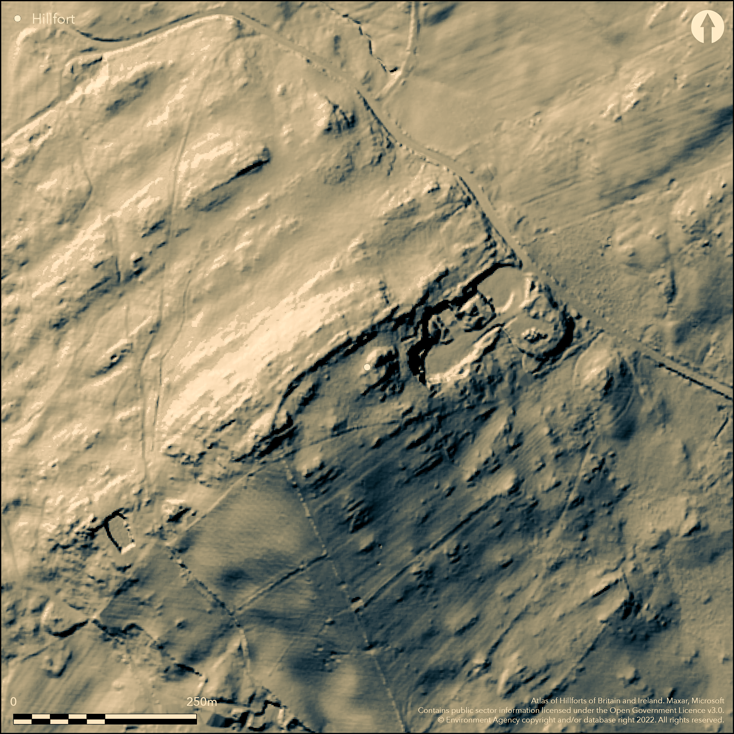
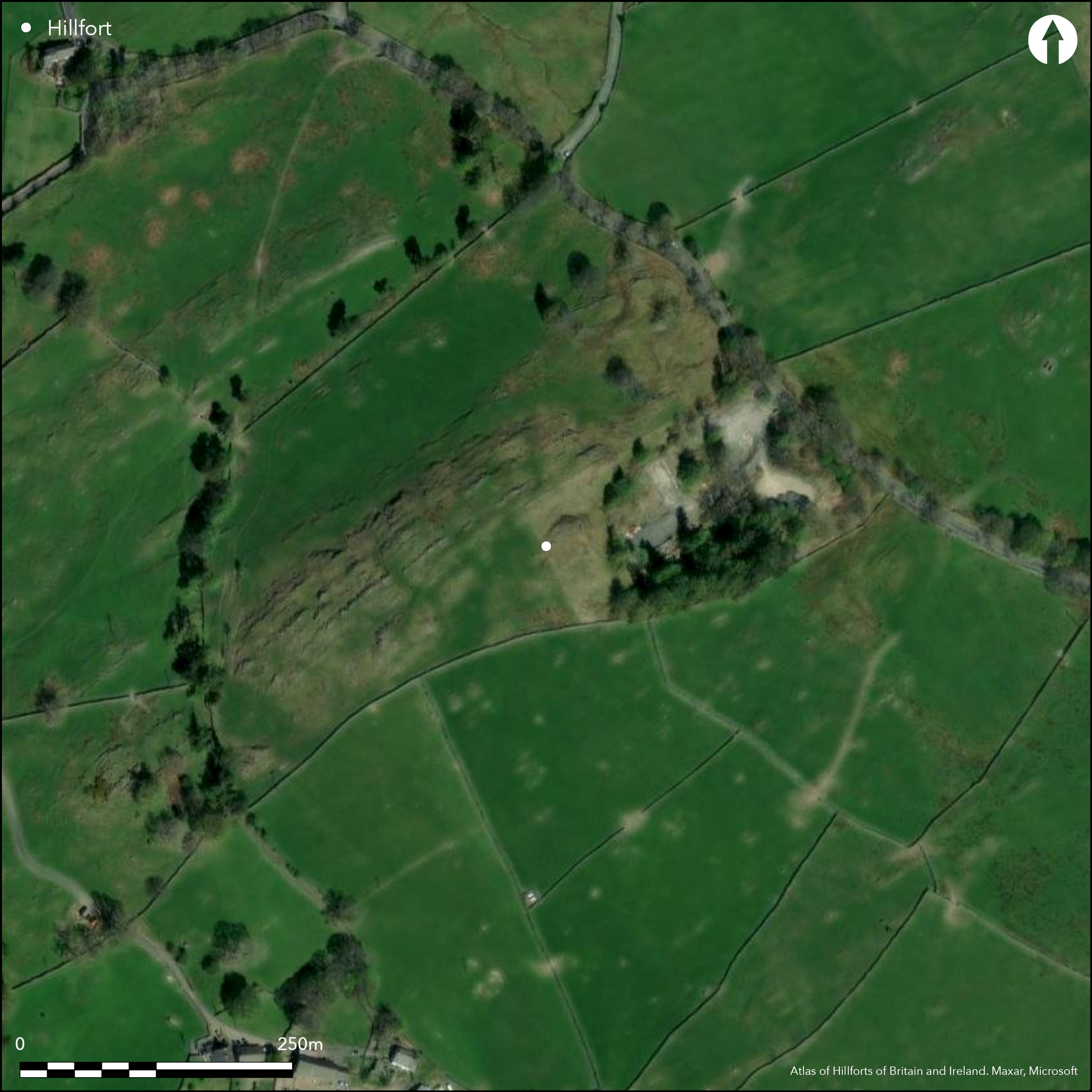
In a strong defensive position on the summit of Allen Knott. A slight univallate hillfort estimated to once cover an area of between 0.8-1.6ha but now destroyed through quarrying in the E and agriculture in the S. It retains a well-defined ditchless earth and stone rampart with stone-revetted bank in the N and W which excavation showed to be 2.4m wide and up to four courses high (Lowndes 1964). No evidence for an entrance or visible surface features have been recorded and the site is undated.
Citizen Science: ✗
Reliability of Data: Confirmed
Reliability of Interpretation: Confirmed
X: -323217 Y: 7246580 (EPSG: 3857)
Longitude: -2.9035079660958054 Latitude: 54.401578393798694 (EPSG:4326)
Country: England
Current County or Unitary Authority: Cumbria
Historic County: Westmorland
Current Parish/Community/Council/Townland: Windermere
Modern quarrying and agriculture have destroyed the southern and eastern extents of the site.
| Extant | ✓ |
| Cropmark | ✗ |
| Likely Destroyed | ✗ |
Appears from satellite imagery to be unimproved grazing. Land owned by the National Trust, No. 20443
| Woodland | ✗ |
| Commercial Forestry Plantation | ✗ |
| Parkland | ✗ |
| Pasture (Grazing) | ✓ |
| Arable | ✗ |
| Scrub/Bracken | ✗ |
| Bare Outcrop | ✗ |
| Heather/Moorland | ✗ |
| Heath | ✗ |
| Built-up | ✗ |
| Coastal Grassland | ✗ |
| Other | ✗ |
A contour fort situated in a strong defensive position at 220m OD on the summit of Allen Knott. From the summit, Lake Windermere, the peaks of Gummers How and Orrest Head, the Langdale Pikes, Crinkle Crags, the Old Man of Coniston and the hills surrounding the Kirkstone Pass are visible.
| Contour Fort | ✓ |
| Partial Contour Fort | ✗ |
| Promontory Fort | ✗ |
| Hillslope Fort | ✗ |
| Level Terrain Fort | ✗ |
| Marsh Fort | ✗ |
| Multiple Enclosure Fort | ✗ |
| Hilltop | ✗ |
| Coastal Promontory | ✗ |
| Inland Promontory | ✗ |
| Valley Bottom | ✗ |
| Knoll/Hillock/Outcrop | ✓ |
| Ridge | ✗ |
| Cliff/Plateau-edge/Scarp | ✗ |
| Hillslope | ✗ |
| Lowland | ✗ |
| Spur | ✗ |
Dominant Topographic Feature: On the summit of Allen Knott
| North | ✗ |
| Northeast | ✗ |
| East | ✗ |
| Southeast | ✗ |
| South | ✗ |
| Southwest | ✗ |
| West | ✗ |
| Northwest | ✗ |
| Level | ✓ |
Altitude: 220.0m
N/A
Undated, presumed Iron Age
Reliability: D - None
| Pre 1200BC | ✗ |
| 1200BC - 800BC | ✗ |
| 800BC - 400BC | ✗ |
| 400BC - AD50 | ✗ |
| AD50 - AD400 | ✗ |
| AD400 - AD 800 | ✗ |
| Post AD800 | ✗ |
| Unknown | ✓ |
| Pre Hillfort: | None |
| Post Hillfort: | Quarrying |
General reference in Collingwood (1913). Limited excavation across the ramparts (Lowndes 1964). Field investigation in 1966 and 1975. Scheduled
| 1st Identified Written Reference (1913): | None |
| Excavation (1963): | Lowndes (1964) |
| Other (1966): | Field investigation |
| Other (1975): | Scheduled |
| Other (1975): | Field investigation |
No known features
None
| None | ✓ |
| Spring | ✗ |
| Stream | ✗ |
| Pool | ✗ |
| Flush | ✗ |
| Well | ✗ |
| Other | ✗ |
None
| No Known Features | ✓ |
| Round Stone Structures | ✗ |
| Rectangular Stone Structures | ✗ |
| Curvilinear Platforms | ✗ |
| Other Roundhouse Evidence | ✗ |
| Pits | ✗ |
| Quarry Hollows | ✗ |
| Other | ✗ |
Ramparts only
| No Known Excavation | ✓ |
| Pits | ✗ |
| Postholes | ✗ |
| Roundhouses | ✗ |
| Rectangular Structures | ✗ |
| Roads/Tracks | ✗ |
| Quarry Hollows | ✗ |
| Other | ✗ |
| Nothing Found | ✗ |
None
| No Known Geophysics | ✓ |
| Pits | ✗ |
| Roundhouses | ✗ |
| Rectangular Structures | ✗ |
| Roads/Tracks | ✗ |
| Quarry Hollows | ✗ |
| Other | ✗ |
| Nothing Found | ✗ |
None
| No Known Finds | ✓ |
| Pottery | ✗ |
| Metal | ✗ |
| Metalworking | ✗ |
| Human Bones | ✗ |
| Animal Bones | ✗ |
| Lithics | ✗ |
| Environmental | ✗ |
| Other | ✗ |
None
| APs Not Checked | ✗ |
| None | ✓ |
| Roundhouses | ✗ |
| Rectangular Structures | ✗ |
| Pits | ✗ |
| Postholes | ✗ |
| Roads/Tracks | ✗ |
| Other | ✗ |
None
| None: | None within surviving ramparts |
| 2: | None |
Guard Chambers: ✗
Chevaux de Frise: ✗
Comprises a ditchless, stone revetted bank with rounded corners. Once covering an area of between 0.8-1.6ha it is now destroyed through quarrying in the E and agriculture in the S. Excavation found the bank to be constructed with an earth and rubble core retained on one side by a drystone wall which survived up to four courses high and 2.4m wide.
| Area 1: | 0.8ha. |
| Total: | 0.8ha. |
Total Footprint Area: Noneha.
Comprises a ditchless, stone revetted bank. Excavation found the bank to be constructed with an earth and rubble core retained on one side by a drystone wall which survived up to four courses high and 2.4m wide.
| ✗ | Area estimated |
| ✗ | Now destroyed in east and south |
| NE Quadrant: | 1 |
| SE Quadrant: | None |
| SW Quadrant: | None |
| NW Quadrant: | 1 |
| Total: | 1 |
| Partial Univallate | ✓ |
| Univallate | ✗ |
| Partial Bivallate | ✗ |
| Bivallate | ✗ |
| Partial Multivallate | ✗ |
| Multivallate | ✗ |
| Unknown | ✗ |
| Partial Univallate | ✗ |
| Univallate | ✗ |
| Partial Bivallate | ✗ |
| Bivallate | ✗ |
| Partial Multivallate | ✗ |
| Multivallate | ✗ |
None
| None | ✗ |
| Earthen Bank | ✓ |
| Stone Wall | ✗ |
| Rubble | ✗ |
| Wall-walk | ✗ |
| Evidence of Timber | ✗ |
| Vitrification | ✗ |
| Other Burning | ✗ |
| Palisade | ✗ |
| Counter Scarp Bank | ✗ |
| Berm | ✗ |
| Unfinished | ✗ |
| Other | ✗ |
Earth and rubble core with dry stone revetted box rampart on one side up Now partially destroyed
| None | ✗ |
| Earthen Bank | ✓ |
| Stone Wall | ✓ |
| Murus Duplex | ✗ |
| Timber-framed | ✗ |
| Timber-laced | ✗ |
| Vitrification | ✗ |
| Other Burning | ✗ |
| Palisade | ✗ |
| Counter Scarp Bank | ✗ |
| Berm | ✗ |
| Unfinished | ✗ |
| No Known Excavation | ✗ |
| Other | ✗ |
| ✗ | None |
| ✗ | None |
Number of Ditches: None
| ✗ | None |
Collingwood, R.G.C. 1913. The Earthworks on Allan Knott. Trans Cumberland Westmorland Antiq Archaeol Soc, 143-6
Lowndes,R.A.C. 1964. Allen Knott Earthwork Trans Cumberland Westmorland Antiq Archaeol Soc New Ser. - Volume: LVIV - 94-7
Atlas of Hillforts:
Wikidata:
This work is licensed under CC BY-SA 4.0![]()
![]()
![]() and should be cited as:
and should be cited as:
Lock, Gary and Ralston, Ian. 2024. Atlas of Hillforts of Britain and Ireland. Available at: https://hillforts.arch.ox.ac.uk
Document Version 1.1