LiDAR 1m DTM Hillshade
Satellite Imagery
LiDAR 1m DTM Hillshade
Satellite Imagery
Scroll left/right to view further images.
HER: Tyne and Wear 13787 (None)
NMR: NZ 35 NE 286 (1547813)
SM: 1402212
NGR: NZ 3798 5522
X: 437980 Y: 555220 (OSGB36)
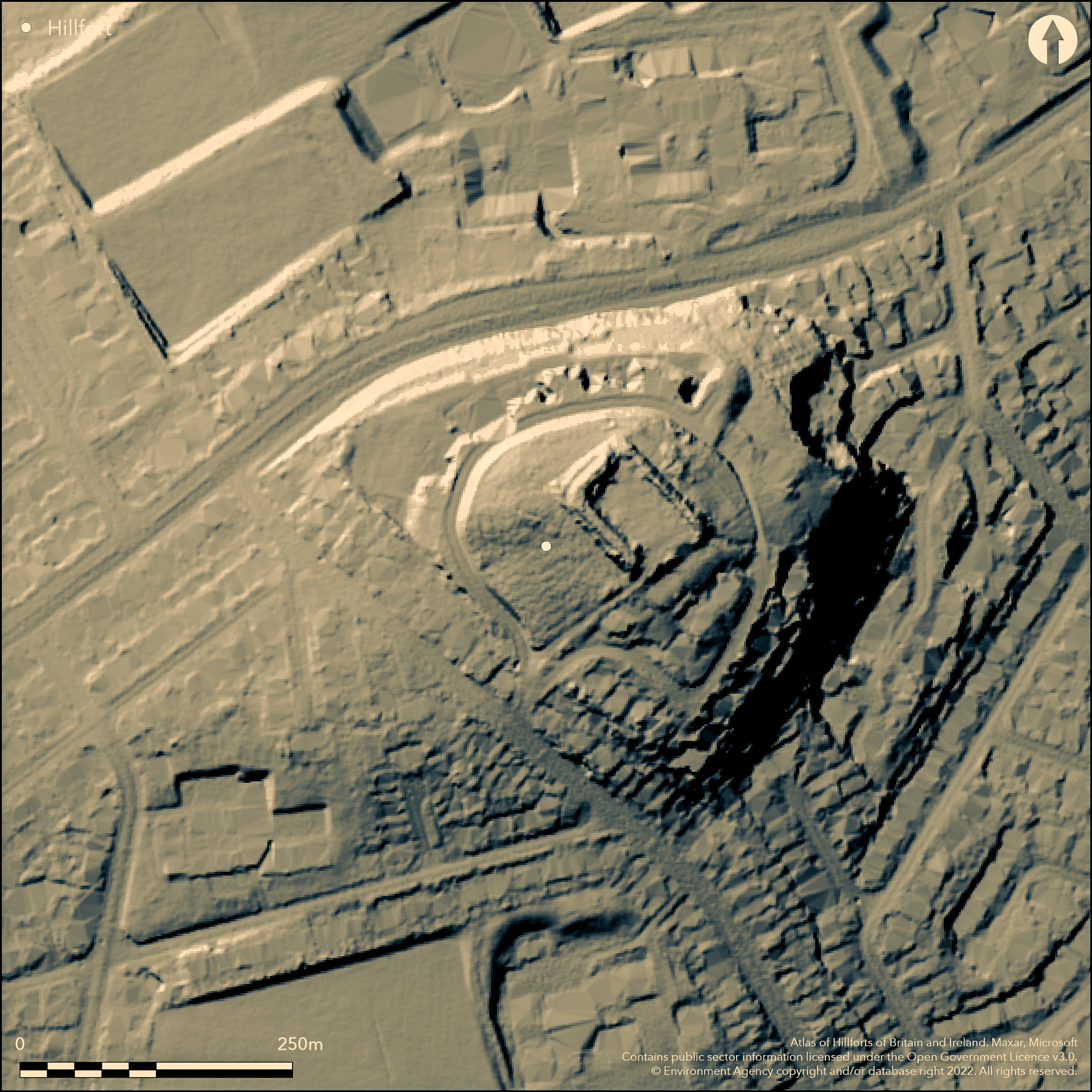
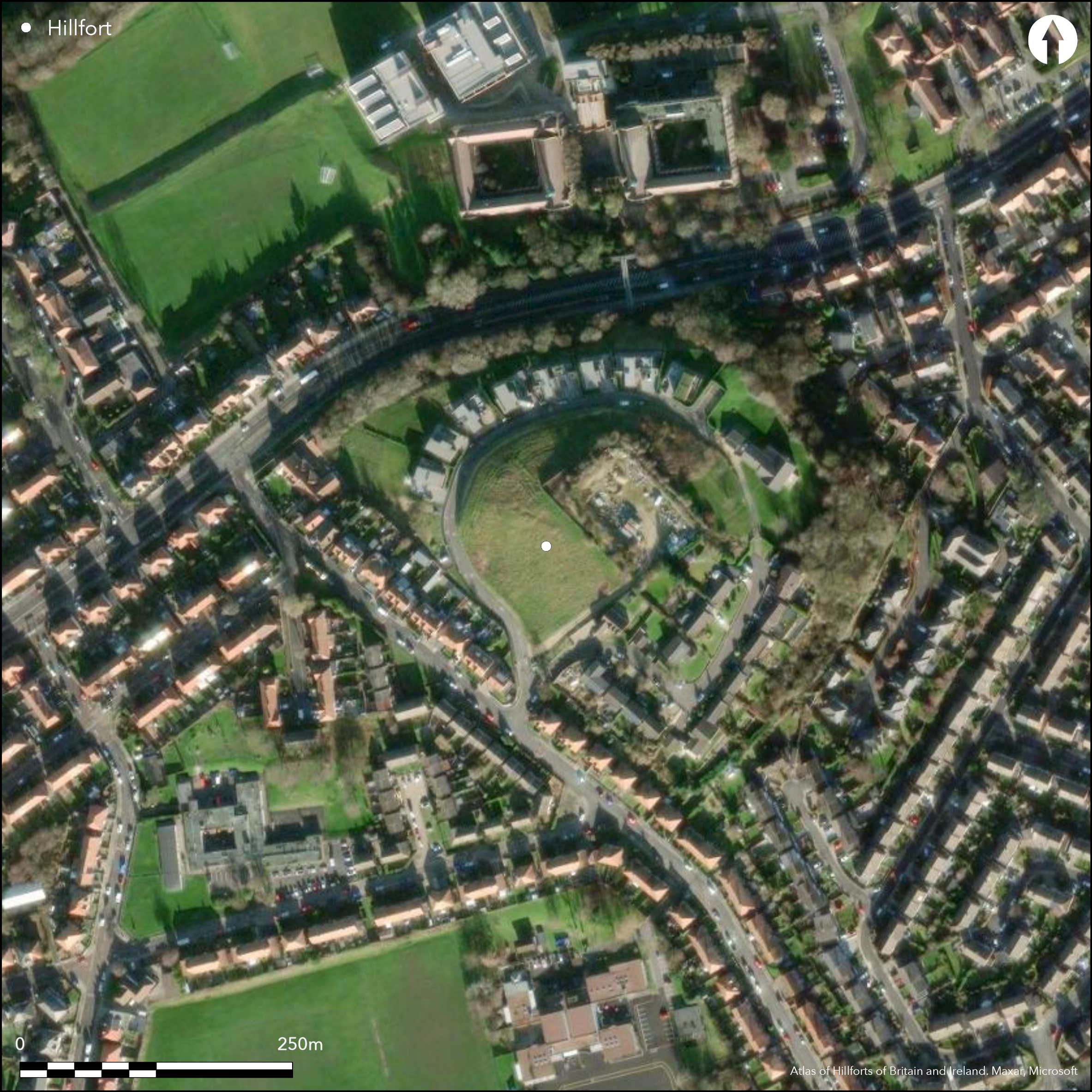
Located within the south-western inner suburbs of Sunderland, a late Bronze Age-early Iron Age defended settlement or hillfort encircling the summit of Humbledon Hill. Lying at approximately 91m OD, the site is scheduled as a rare survival of a lowland coastal hillfort or defended settlement. The enclosure is roughly circular, measuring 75m NE to SW by 62m NW to SE, comprising two ditches 9m apart with a bank between. The outer ditch is 3m wide and 1m deep and the inner ditch, which is considered to be the remains of a palisade trench, 0.5m deep by 0.5m wide. The stone and earth bank, interpreted as the remains of a rampart, survives to a height of 0.8m. The only known entrance lies in the W. Two ditched features immediately outside the settlement on the S and SW sides, with the same character as the outer, more substantial ditch, are considered to be the remains of structures associated with the larger enclosure. The site, which is now partially destroyed by housing and a Victorian reservoir, survives only in the W as the buried remains of ditches, and partially surviving banks. Geophysical survey in 2003 revealed the ditches and other anomalies, probably pits 2m in diameter, and a possible Bronze Age round cairn, within the enclosure (Hale and Still 2003). The construction of the reservoir in 1873 removed a barrow and revealed several cinerary urns with associated cremation burials and at least two inhumations with associated grave goods. Pottery recovered from the ditches during excavations in 2006-7 suggests the site developed in the Iron Age from the late Bronze Age palisaded enclosure (Gaskell 2007). A possible Bronze Age cairn was also uncovered during the excavations. Not recorded on OS mapping.
Citizen Science: ✗
Reliability of Data: Confirmed
Reliability of Interpretation: Confirmed
X: -156895 Y: 7340606 (EPSG: 3857)
Longitude: -1.409411436235919 Latitude: 54.89030519107195 (EPSG:4326)
Country: England
Current County or Unitary Authority: Tyne and Wear
Historic County: County Durham
Current Parish/Community/Council/Townland: Sunderland
Sub-surface ditches with a surviving bank
| Extant | ✓ |
| Cropmark | ✗ |
| Likely Destroyed | ✓ |
Housing Estate with rough grassland in the W
| Woodland | ✗ |
| Commercial Forestry Plantation | ✗ |
| Parkland | ✗ |
| Pasture (Grazing) | ✗ |
| Arable | ✗ |
| Scrub/Bracken | ✗ |
| Bare Outcrop | ✗ |
| Heather/Moorland | ✗ |
| Heath | ✗ |
| Built-up | ✓ |
| Coastal Grassland | ✗ |
| Other | ✓ |
A two-phase contour fort lying at 91m OD on the summit of Humbledon Hill.
| Contour Fort | ✓ |
| Partial Contour Fort | ✗ |
| Promontory Fort | ✗ |
| Hillslope Fort | ✗ |
| Level Terrain Fort | ✗ |
| Marsh Fort | ✗ |
| Multiple Enclosure Fort | ✗ |
| Hilltop | ✓ |
| Coastal Promontory | ✗ |
| Inland Promontory | ✗ |
| Valley Bottom | ✗ |
| Knoll/Hillock/Outcrop | ✗ |
| Ridge | ✗ |
| Cliff/Plateau-edge/Scarp | ✗ |
| Hillslope | ✗ |
| Lowland | ✗ |
| Spur | ✗ |
Dominant Topographic Feature: None
| North | ✗ |
| Northeast | ✗ |
| East | ✗ |
| Southeast | ✗ |
| South | ✗ |
| Southwest | ✗ |
| West | ✗ |
| Northwest | ✗ |
| Level | ✓ |
Altitude: 91.0m
N/A
Discoveries of a barrow, several cinerary urns with associated cremation burials, and at least two inhumations with grave goods were made in 1873 during the construction of the reservoir. Investigations in 2006-7 produced prehistoric pottery from the ditches and a possible Iron Age loom weight fragment
Reliability: B - Medium
| Pre 1200BC | ✗ |
| 1200BC - 800BC | ✗ |
| 800BC - 400BC | ✓ |
| 400BC - AD50 | ✓ |
| AD50 - AD400 | ✗ |
| AD400 - AD 800 | ✗ |
| Post AD800 | ✗ |
| Unknown | ✗ |
| Pre Hillfort: | None |
| Post Hillfort: | None |
| Artefactual: | Animal bone, some burnt; flint and pottery fragments, fragment of a possible Iron Age loom weight |
During the construction the reservoir in 1873 a large round barrow containing three Bronze Age pottery vessels and associated cremations, two inhumations and an iron knife were discovered. Geophysical survey in 2003 revealed the buried remains of the settlement. Limited archaeological evaluation in 2006-7 confirmed the presence of a double ditched enclosure. Fragments of pottery, considered prehistoric, recovered from the ditches demonstrated that the inner ditch was dug during the later Bronze Age, probably for a palisade and the outer ditch during the Iron Age. Scheduled
| Geophysical Survey (2003): | None |
| Other (2011): | Scheduled |
| Excavation (None): | None |
Geophysical survey in 2003 revealed anomalies, probably pits 2m in diameter, and a possible Bronze Age round cairn within the enclosure (Hale and Still 2003).
None
| None | ✓ |
| Spring | ✗ |
| Stream | ✗ |
| Pool | ✗ |
| Flush | ✗ |
| Well | ✗ |
| Other | ✗ |
None
| No Known Features | ✓ |
| Round Stone Structures | ✗ |
| Rectangular Stone Structures | ✗ |
| Curvilinear Platforms | ✗ |
| Other Roundhouse Evidence | ✗ |
| Pits | ✗ |
| Quarry Hollows | ✗ |
| Other | ✗ |
None
| No Known Excavation | ✗ |
| Pits | ✓ |
| Postholes | ✗ |
| Roundhouses | ✗ |
| Rectangular Structures | ✗ |
| Roads/Tracks | ✗ |
| Quarry Hollows | ✗ |
| Other | ✗ |
| Nothing Found | ✗ |
None
| No Known Geophysics | ✗ |
| Pits | ✓ |
| Roundhouses | ✗ |
| Rectangular Structures | ✗ |
| Roads/Tracks | ✗ |
| Quarry Hollows | ✗ |
| Other | ✗ |
| Nothing Found | ✗ |
None
| No Known Finds | ✗ |
| Pottery | ✓ |
| Metal | ✗ |
| Metalworking | ✗ |
| Human Bones | ✗ |
| Animal Bones | ✓ |
| Lithics | ✓ |
| Environmental | ✗ |
| Other | ✓ |
None
| APs Not Checked | ✓ |
| None | ✗ |
| Roundhouses | ✗ |
| Rectangular Structures | ✗ |
| Pits | ✗ |
| Postholes | ✗ |
| Roads/Tracks | ✗ |
| Other | ✗ |
Surviving single entrance in the W, remainder of enclosing works destroyed
| None: | None |
| 2: | None |
Guard Chambers: ✗
Chevaux de Frise: ✗
| 1. Simple Gap (West): | None |
Surviving only in the W. Outer ditch 3m wide and 1m deep and the inner ditch considered to be the remains of a palisade trench 0.5m deep by 0.5m wide. Between the two ditches is a stone and earth rampart 0.8m high.
| Area 1: | 0.36ha. |
| Total: | 0.36ha. |
Total Footprint Area: Noneha.
None
| ✓ | Site almost destroyed, enclosed area estimated from dimensions. Gaskell (2007) suggests the site developed in the Iron Age from the late Bronze Age palisaded enclosure |
| ✗ | Survive only in the west |
| NE Quadrant: | None |
| SE Quadrant: | None |
| SW Quadrant: | 1 |
| NW Quadrant: | 1 |
| Total: | 1 |
| Partial Univallate | ✓ |
| Univallate | ✗ |
| Partial Bivallate | ✗ |
| Bivallate | ✗ |
| Partial Multivallate | ✗ |
| Multivallate | ✗ |
| Unknown | ✗ |
| Partial Univallate | ✗ |
| Univallate | ✗ |
| Partial Bivallate | ✗ |
| Bivallate | ✗ |
| Partial Multivallate | ✗ |
| Multivallate | ✗ |
None
| None | ✗ |
| Earthen Bank | ✓ |
| Stone Wall | ✗ |
| Rubble | ✗ |
| Wall-walk | ✗ |
| Evidence of Timber | ✗ |
| Vitrification | ✗ |
| Other Burning | ✗ |
| Palisade | ✗ |
| Counter Scarp Bank | ✗ |
| Berm | ✗ |
| Unfinished | ✗ |
| Other | ✗ |
Stone and earth bank
| None | ✗ |
| Earthen Bank | ✓ |
| Stone Wall | ✗ |
| Murus Duplex | ✗ |
| Timber-framed | ✗ |
| Timber-laced | ✗ |
| Vitrification | ✗ |
| Other Burning | ✗ |
| Palisade | ✓ |
| Counter Scarp Bank | ✗ |
| Berm | ✗ |
| Unfinished | ✗ |
| No Known Excavation | ✗ |
| Other | ✓ |
| ✗ | None |
| ✓ | Second considered to be a palisade trench |
Number of Ditches: 1
| ✗ | None |
Gaskell, N. 2007. Archaeological Evaluation on Land at 24 Alpine Way, Sunderland, Tyne and Wear, CP/558/07. NPA Ltd: Nenthead, Cumbria. Unpublished Report
Hale, D. and Still, D. 2003. Geophysical Surveys at Picktree, Chester-le-Street and Humbledon Hill, Sunderland. Durham Archaeol J. 17
Atlas of Hillforts:
Wikidata:
This work is licensed under CC BY-SA 4.0![]()
![]()
![]() and should be cited as:
and should be cited as:
Lock, Gary and Ralston, Ian. 2024. Atlas of Hillforts of Britain and Ireland. Available at: https://hillforts.arch.ox.ac.uk
Document Version 1.1