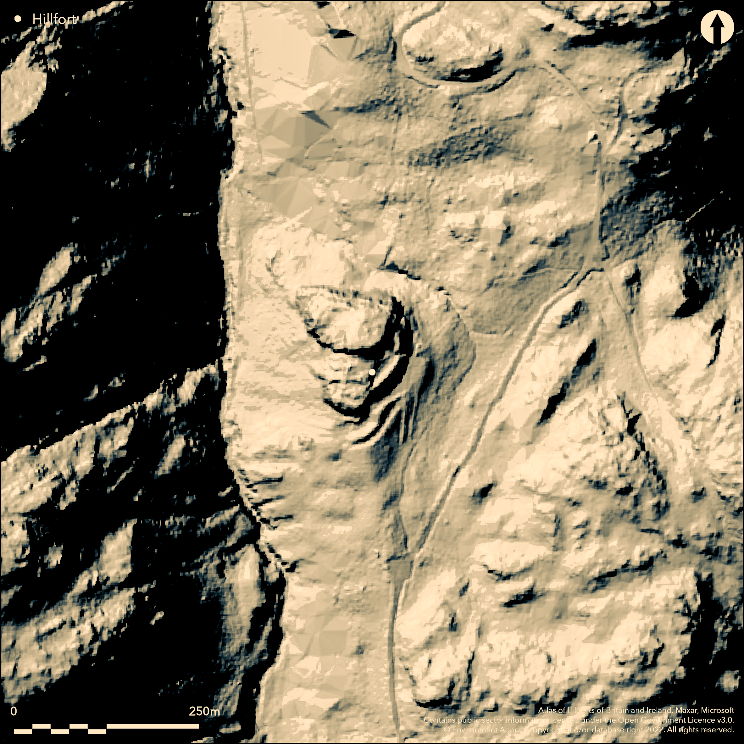
LiDAR 1m DTM Hillshade
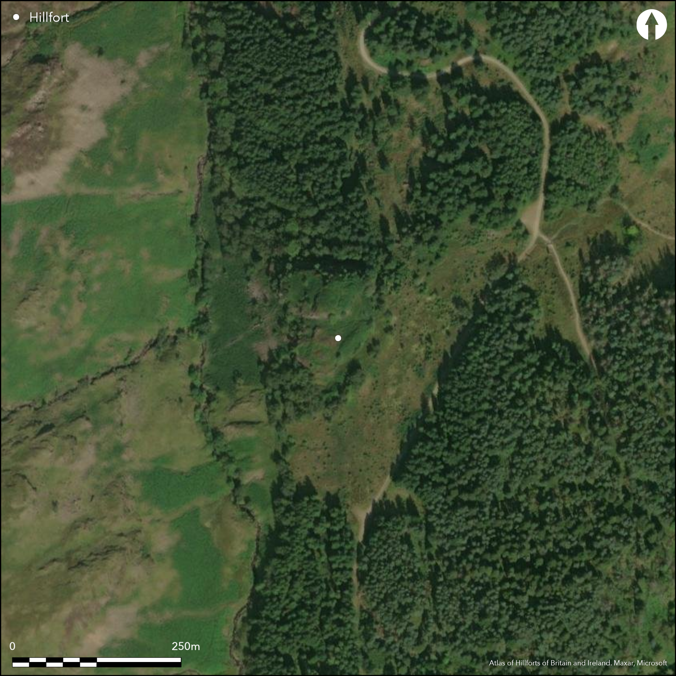
Satellite Imagery
LiDAR 1m DTM Hillshade
Satellite Imagery
Scroll left/right to view further images.
HER: Lake District National Park 5497 (None)
NMR: NY 21 NE 2 (9786)
SM: 1012942
NGR: NY 29989 18844
X: 329989 Y: 518844 (OSGB36)
In the gill above Shoulthwaite, a roughly oval hillfort 140m by 90m sited at 396m OD on the rocky knoll of Castle Crag. Of uncertain date and could possibly be Roman or post-Roman. The site is defended in the N and W by precipitous natural slopes. Bivallate, in the S and E there is an earth and stone rampart up to 6.5m high and approximately 12-15m wide at the base, with an internal ditch. In the SE further defensive earthworks include two closely-spaced banks up to 3m high and two ditches up to 8m wide. At the northern end of these, adjacent to the eastern side of the earth and stone bank, is a level area measuring 28m by 16m. To the S of the knoll is a relatively flat, sub-oval area containing two rectangular rock-cut levelled platforms measuring approximately 21m by 9m and 8m by 7m and also a rectangular shallow rock-cut depression measuring 25m by 7m. A simple, narrow gap entrance close to the foot of the knoll in the E leads to the summit. The interior is rocky and uneven with three rock-cut levelled areas measuring between 6m and 3m are interpreted as hut platforms. The site was investigated in the late 1990's (Huckerby 1999) when a ditch to the S of the entrance was confirmed. A late 6th-early 7th century AD date was provided by radiocarbon dating although it is uncertain if the site was constructed then or in an earlier period and reused. 'Fort' is shown on 1885-1900 OS mapping and its outline depicted on 1888-1913 mapping. Scheduled
Citizen Science: ✗
Reliability of Data: Confirmed
Reliability of Interpretation: Confirmed
X: -343328 Y: 7276932 (EPSG: 3857)
Longitude: -3.0841683370397206 Latitude: 54.55998170598994 (EPSG:4326)
Country: England
Current County or Unitary Authority: Cumbria
Historic County: Cumberland
Current Parish/Community/Council/Townland: St John's Castlerigg and Wythburn
None
| Extant | ✓ |
| Cropmark | ✗ |
| Likely Destroyed | ✗ |
A well-preserved enclosure sited on a bare outcrop with patches of heather
| Woodland | ✗ |
| Commercial Forestry Plantation | ✗ |
| Parkland | ✗ |
| Pasture (Grazing) | ✗ |
| Arable | ✗ |
| Scrub/Bracken | ✗ |
| Bare Outcrop | ✗ |
| Heather/Moorland | ✓ |
| Heath | ✗ |
| Built-up | ✗ |
| Coastal Grassland | ✗ |
| Other | ✗ |
A multiple enclosure hillfort located on a rocky knoll or promontory at 396m OD
| Contour Fort | ✗ |
| Partial Contour Fort | ✗ |
| Promontory Fort | ✗ |
| Hillslope Fort | ✗ |
| Level Terrain Fort | ✗ |
| Marsh Fort | ✗ |
| Multiple Enclosure Fort | ✓ |
| Hilltop | ✗ |
| Coastal Promontory | ✗ |
| Inland Promontory | ✗ |
| Valley Bottom | ✗ |
| Knoll/Hillock/Outcrop | ✓ |
| Ridge | ✗ |
| Cliff/Plateau-edge/Scarp | ✗ |
| Hillslope | ✗ |
| Lowland | ✗ |
| Spur | ✗ |
Dominant Topographic Feature: Sited on a rocky knoll
| North | ✗ |
| Northeast | ✗ |
| East | ✗ |
| Southeast | ✗ |
| South | ✗ |
| Southwest | ✗ |
| West | ✗ |
| Northwest | ✗ |
| Level | ✓ |
Altitude: 396.0m
N/A
Three radiocarbon dates provided 6th-7th century dates for the site, but its origins could be earlier and reused
Reliability: B - Medium
| Pre 1200BC | ✗ |
| 1200BC - 800BC | ✗ |
| 800BC - 400BC | ✗ |
| 400BC - AD50 | ✗ |
| AD50 - AD400 | ✗ |
| AD400 - AD 800 | ✓ |
| Post AD800 | ✗ |
| Unknown | ✗ |
| Pre Hillfort: | None |
| Post Hillfort: | None |
| C14: | AD 538 - 676 and cal AD 560 - 690 |
Recorded on 1885-1900 OS mapping. General reference in Collingwood (1924, 82). Field investigation in 1978. Feld survey in 1996 by Lancaster University Archaeological Unit (LUAU) with a detailed survey carried out in 1997. A stratigraphic survey was undertaken in 1998 immediately to the S of the entrance through an area of land that is currently a mire, in order to investigate the possibility of buried ramparts and to assess the potential for further environmental investigation. A series of core transects showed the ditch to be steep edged but flat-bottomed, in contrast with the adjacent V-shaped rampart ditches to the S. Evidence suggests this had been water-filled and might have served as a moat. it was not possible to determine whether this had been the primary cut or a re-cut of an earlier defensive feature. Three cored sections taken for radiocarbon dating with material from near the base of the ditch providing a date of cal AD 538 - 676 and cal AD 560 - 690 (95% confidence limit).
| 1st Identified Written Reference (1924): | None |
| Other (1924): | Scheduled |
| Other (1978): | Field Investigation |
| Earthwork Survey (1997): | None |
| Other (1998): | Three cores taken for C14 dating |
| Other (1998): | Stratigraphic survey |
| 1st Identified Map Depiction (None): | OS one inch |
Three rock-cut levelled areas lie on the summit measuring between 6m and 3m are interpreted as hut platforms.
Springs to the E of the enclosure
| None | ✓ |
| Spring | ✗ |
| Stream | ✗ |
| Pool | ✗ |
| Flush | ✗ |
| Well | ✗ |
| Other | ✗ |
Rock-cut levelled areas interpreted as hut platforms
| No Known Features | ✗ |
| Round Stone Structures | ✗ |
| Rectangular Stone Structures | ✗ |
| Curvilinear Platforms | ✗ |
| Other Roundhouse Evidence | ✗ |
| Pits | ✗ |
| Quarry Hollows | ✗ |
| Other | ✓ |
None
| No Known Excavation | ✓ |
| Pits | ✗ |
| Postholes | ✗ |
| Roundhouses | ✗ |
| Rectangular Structures | ✗ |
| Roads/Tracks | ✗ |
| Quarry Hollows | ✗ |
| Other | ✗ |
| Nothing Found | ✗ |
None
| No Known Geophysics | ✓ |
| Pits | ✗ |
| Roundhouses | ✗ |
| Rectangular Structures | ✗ |
| Roads/Tracks | ✗ |
| Quarry Hollows | ✗ |
| Other | ✗ |
| Nothing Found | ✗ |
None
| No Known Finds | ✓ |
| Pottery | ✗ |
| Metal | ✗ |
| Metalworking | ✗ |
| Human Bones | ✗ |
| Animal Bones | ✗ |
| Lithics | ✗ |
| Environmental | ✗ |
| Other | ✗ |
None
| APs Not Checked | ✓ |
| None | ✗ |
| Roundhouses | ✗ |
| Rectangular Structures | ✗ |
| Pits | ✗ |
| Postholes | ✗ |
| Roads/Tracks | ✗ |
| Other | ✗ |
A simple gap in the E cuts through the bank close to the foot of the knoll
| None: | None |
| 2: | None |
Guard Chambers: ✗
Chevaux de Frise: ✗
| 1. Simple Gap (East): | None |
An earth and stone rampart up to 6.5m high and approximately 12-15m wide at the base, with an internal ditch in the S and E. Beyond this further defensive earthworks include two closely-spaced banks up to 3m high and ditches up to 8m wide, which defend the site from the easiest line of approach.
| Area 1: | 1.0ha. |
| Total: | 1.0ha. |
Total Footprint Area: Noneha.
None
| ✗ | None |
| ✗ | Two banks in the north and three in the south and east |
| NE Quadrant: | 2 |
| SE Quadrant: | 3 |
| SW Quadrant: | None |
| NW Quadrant: | None |
| Total: | 3 |
| Partial Univallate | ✗ |
| Univallate | ✗ |
| Partial Bivallate | ✓ |
| Bivallate | ✗ |
| Partial Multivallate | ✓ |
| Multivallate | ✗ |
| Unknown | ✗ |
| Partial Univallate | ✗ |
| Univallate | ✗ |
| Partial Bivallate | ✗ |
| Bivallate | ✗ |
| Partial Multivallate | ✗ |
| Multivallate | ✗ |
None
| None | ✗ |
| Earthen Bank | ✓ |
| Stone Wall | ✗ |
| Rubble | ✓ |
| Wall-walk | ✗ |
| Evidence of Timber | ✗ |
| Vitrification | ✗ |
| Other Burning | ✗ |
| Palisade | ✗ |
| Counter Scarp Bank | ✗ |
| Berm | ✗ |
| Unfinished | ✗ |
| Other | ✗ |
None
| None | ✗ |
| Earthen Bank | ✗ |
| Stone Wall | ✗ |
| Murus Duplex | ✗ |
| Timber-framed | ✗ |
| Timber-laced | ✗ |
| Vitrification | ✗ |
| Other Burning | ✗ |
| Palisade | ✗ |
| Counter Scarp Bank | ✗ |
| Berm | ✗ |
| Unfinished | ✗ |
| No Known Excavation | ✓ |
| Other | ✗ |
| ✗ | None |
| ✓ | None |
Number of Ditches: 3
| ✗ | None |
Challis, A.J. and Harding, D.W., 1975. Later prehistory from the Trent to the Tyne BAR British Series 1 (1974) - 20 (ii)
Collingwood, R.G. 1924: Castle How, Peel Wyke.-Trans Cumberland and Westmorland Antiq Archaeol Soc New Series, Volume: 24: 82
Hogg, A.H.A. 1979. British Hill-Forts. An Index. British Archaeological Reports, British Series 62.
Huckerby, E. 1999. Shoulthwaite Hillfort, Thirlmere, Cumbria: stratigraphic survey report. Lancaster University Archaeological Unit. Unpublished.
Atlas of Hillforts:
Wikidata:
This work is licensed under CC BY-SA 4.0![]()
![]()
![]() and should be cited as:
and should be cited as:
Lock, Gary and Ralston, Ian. 2024. Atlas of Hillforts of Britain and Ireland. Available at: https://hillforts.arch.ox.ac.uk
Document Version 1.1