LiDAR 1m DTM Hillshade

Satellite Imagery
LiDAR 1m DTM Hillshade
Satellite Imagery
Scroll left/right to view further images.
HER: County Durham 2402292 (2303627, 2402293, 2303627, 2744876, 2303627)
NMR: NZ 24 SE 38 (24516)
SM: 1008844
NGR: NZ 28297 41697
X: 428297 Y: 541697 (OSGB36)
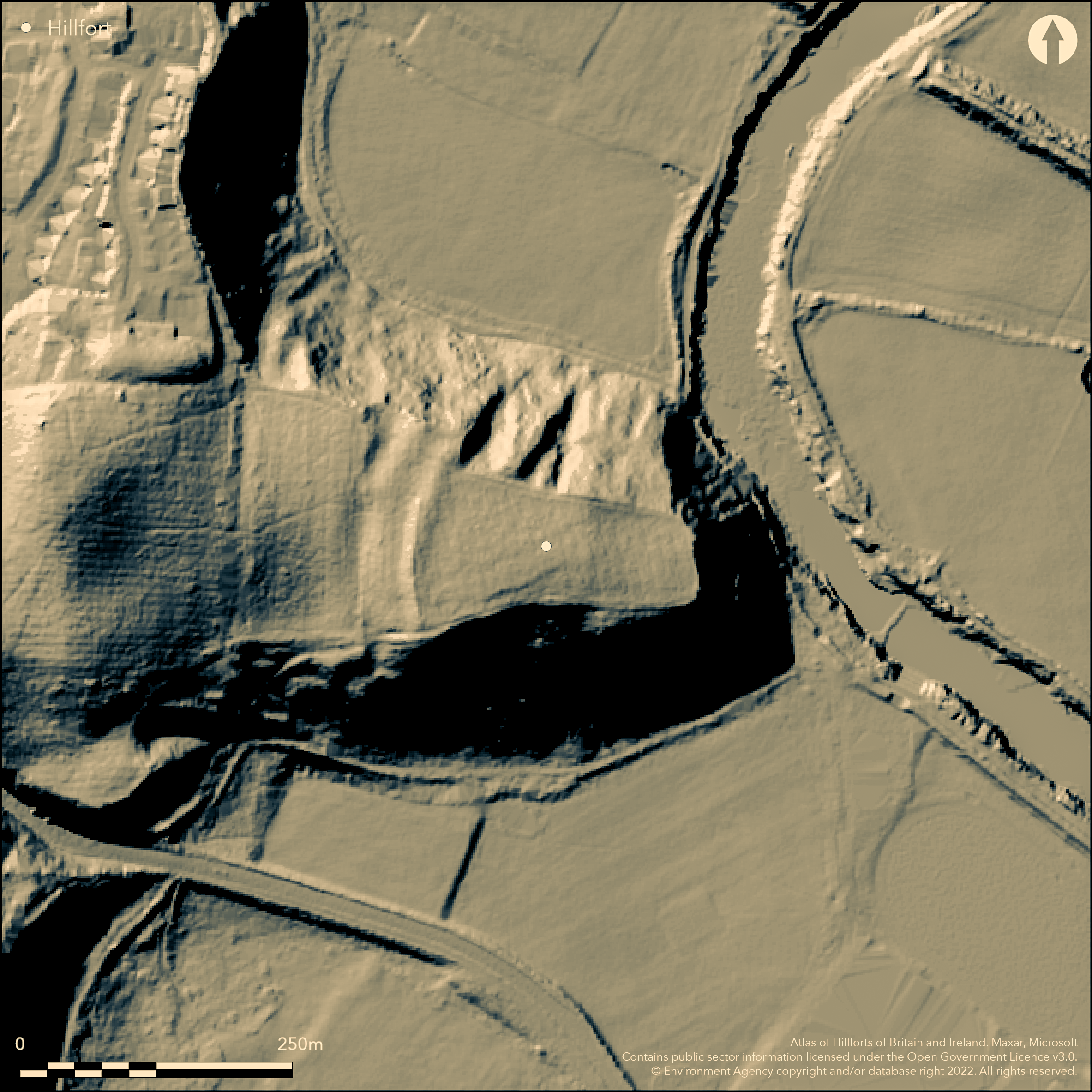
Lying within Maiden Castle Wood to the E of the city of Durham, a promontory fort of 1.23ha. Shown on a drawing of 1773. It lies at 68m OD overlooking the River Wear and its floodplain and is naturally defended by steep slopes except in the W where a single bank 5.5m high by 2m wide and outer ditch 2m deep defend the easiest approach measuring 145m E-W by 50m transversely at the eastern end and 120m at the W, enclosing a wedge-shaped area. A break in the ditch at the northern end of the rampart is possibly original. Limited excavation of the ramparts in 1947 (Jarrett 1958-65) revealed three phases of construction beginning with a clay rampart externally revetted with cobbles and surmounted by a wooden palisade. At a later date the rampart was cut away and a stone wall constructed, strengthened with wooden stakes. A stone bearing a medieval masons mark suggests this was a medieval or post medieval enhancement. The stakes were later burnt. Pottery fragments of a 15th and 16th century date were recovered from the topsoil. The interior of the earthwork is now wooded and no surface features are known. The location and morphology of the fort strongly suggests an Iron Age date with later activity.
Citizen Science: ✗
Reliability of Data: Confirmed
Reliability of Interpretation: Confirmed
X: -173846 Y: 7317244 (EPSG: 3857)
Longitude: -1.5616833311144258 Latitude: 54.76942301881834 (EPSG:4326)
Country: England
Current County or Unitary Authority: County Durham
Historic County: County Durham
Current Parish/Community/Council/Townland: Durham
Deep ploughing associated with the planting of the woodland has caused damage across the interior and the bank in the W, reducing it to an outward facing scarp up to 3 m high, with only minimal traces of a counter scarp towards the southern end.
| Extant | ✓ |
| Cropmark | ✗ |
| Likely Destroyed | ✗ |
Planted with mixed conifers and deciduous trees
| Woodland | ✓ |
| Commercial Forestry Plantation | ✗ |
| Parkland | ✗ |
| Pasture (Grazing) | ✗ |
| Arable | ✗ |
| Scrub/Bracken | ✗ |
| Bare Outcrop | ✗ |
| Heather/Moorland | ✗ |
| Heath | ✗ |
| Built-up | ✗ |
| Coastal Grassland | ✗ |
| Other | ✗ |
Promontory fort situated at 68m on a precipitous promontory above the River Wear
| Contour Fort | ✗ |
| Partial Contour Fort | ✗ |
| Promontory Fort | ✓ |
| Hillslope Fort | ✗ |
| Level Terrain Fort | ✗ |
| Marsh Fort | ✗ |
| Multiple Enclosure Fort | ✗ |
| Hilltop | ✗ |
| Coastal Promontory | ✗ |
| Inland Promontory | ✓ |
| Valley Bottom | ✗ |
| Knoll/Hillock/Outcrop | ✗ |
| Ridge | ✗ |
| Cliff/Plateau-edge/Scarp | ✗ |
| Hillslope | ✗ |
| Lowland | ✗ |
| Spur | ✓ |
Dominant Topographic Feature: Spur
| North | ✗ |
| Northeast | ✗ |
| East | ✗ |
| Southeast | ✗ |
| South | ✗ |
| Southwest | ✗ |
| West | ✗ |
| Northwest | ✗ |
| Level | ✓ |
Altitude: 68.0m
N/A
Nothing contemporary with what is thought to be the main period of construction and use of the hillfort
Reliability: D - None
| Pre 1200BC | ✗ |
| 1200BC - 800BC | ✗ |
| 800BC - 400BC | ✗ |
| 400BC - AD50 | ✗ |
| AD50 - AD400 | ✗ |
| AD400 - AD 800 | ✗ |
| Post AD800 | ✗ |
| Unknown | ✓ |
| Pre Hillfort: | None |
| Post Hillfort: | None |
| Artefactual: | Topsoil finds of 15th or 16th century pottery fragments |
Limited excavations across the ramparts in 1947 (Jarrett 1958-65). Field investigation in 1954 and 1980. Scheduled.
| Other (1773): | Image. View towards the 'Roman hillfort', Samuel Hieronymus Grimm |
| Other (1926): | Scheduled |
| Excavation (1947): | None |
| Other (1954): | Field investigation |
| Other (1980): | Field investigation |
None other than medieval pottery from surface.
None
| None | ✓ |
| Spring | ✗ |
| Stream | ✗ |
| Pool | ✗ |
| Flush | ✗ |
| Well | ✗ |
| Other | ✗ |
Wooded
| No Known Features | ✓ |
| Round Stone Structures | ✗ |
| Rectangular Stone Structures | ✗ |
| Curvilinear Platforms | ✗ |
| Other Roundhouse Evidence | ✗ |
| Pits | ✗ |
| Quarry Hollows | ✗ |
| Other | ✗ |
None
| No Known Excavation | ✓ |
| Pits | ✗ |
| Postholes | ✗ |
| Roundhouses | ✗ |
| Rectangular Structures | ✗ |
| Roads/Tracks | ✗ |
| Quarry Hollows | ✗ |
| Other | ✗ |
| Nothing Found | ✗ |
None
| No Known Geophysics | ✓ |
| Pits | ✗ |
| Roundhouses | ✗ |
| Rectangular Structures | ✗ |
| Roads/Tracks | ✗ |
| Quarry Hollows | ✗ |
| Other | ✗ |
| Nothing Found | ✗ |
Medieval pottery
| No Known Finds | ✗ |
| Pottery | ✗ |
| Metal | ✗ |
| Metalworking | ✗ |
| Human Bones | ✗ |
| Animal Bones | ✗ |
| Lithics | ✗ |
| Environmental | ✗ |
| Other | ✓ |
Wooded
| APs Not Checked | ✓ |
| None | ✗ |
| Roundhouses | ✗ |
| Rectangular Structures | ✗ |
| Pits | ✗ |
| Postholes | ✗ |
| Roads/Tracks | ✗ |
| Other | ✗ |
Single gap entrance in the N, with tentative entrance in the S
| 2: | A second gap lies at the extreme S end of the defences, but a landscaped path has confused the earthworks |
| 2: | None |
Guard Chambers: ✗
Chevaux de Frise: ✗
| 1. Simple Gap (North): | None |
Bank 5.5m high by 2m wide and ditch 2m deep in the W it encloses a wedge-shaped area 145m E-W by 50m transversely at the eastern end, and 120m at the W. Stone walling and palisade discovered during excavation. Further low banks bordering the landscaped path are possibly associated with that feature. Possible counterscarp at S.
| Area 1: | 1.23ha. |
| Total: | 1.23ha. |
Total Footprint Area: Noneha.
None
| ✗ | None |
| ✗ | None |
| NE Quadrant: | None |
| SE Quadrant: | None |
| SW Quadrant: | 1 |
| NW Quadrant: | 1 |
| Total: | 1 |
| Partial Univallate | ✓ |
| Univallate | ✗ |
| Partial Bivallate | ✗ |
| Bivallate | ✗ |
| Partial Multivallate | ✗ |
| Multivallate | ✗ |
| Unknown | ✗ |
| Partial Univallate | ✗ |
| Univallate | ✗ |
| Partial Bivallate | ✗ |
| Bivallate | ✗ |
| Partial Multivallate | ✗ |
| Multivallate | ✗ |
Slight traces of a counterscarp bank are visible inside the rampart towards its southern end.
| None | ✗ |
| Earthen Bank | ✗ |
| Stone Wall | ✗ |
| Rubble | ✗ |
| Wall-walk | ✗ |
| Evidence of Timber | ✗ |
| Vitrification | ✗ |
| Other Burning | ✗ |
| Palisade | ✗ |
| Counter Scarp Bank | ✓ |
| Berm | ✗ |
| Unfinished | ✗ |
| Other | ✗ |
None
| None | ✗ |
| Earthen Bank | ✓ |
| Stone Wall | ✓ |
| Murus Duplex | ✗ |
| Timber-framed | ✗ |
| Timber-laced | ✗ |
| Vitrification | ✗ |
| Other Burning | ✓ |
| Palisade | ✓ |
| Counter Scarp Bank | ✗ |
| Berm | ✗ |
| Unfinished | ✗ |
| No Known Excavation | ✗ |
| Other | ✗ |
| ✗ | None |
| ✓ | None |
Number of Ditches: 1
| ✗ | None |
Jarrett, M.G. 1965. Excavations at Maiden Castle, Durham in 1956. Durham and Northum Archaeol Architec Soc Vol.11, 124-7
Atlas of Hillforts:
Wikidata:
This work is licensed under CC BY-SA 4.0![]()
![]()
![]() and should be cited as:
and should be cited as:
Lock, Gary and Ralston, Ian. 2024. Atlas of Hillforts of Britain and Ireland. Available at: https://hillforts.arch.ox.ac.uk
Document Version 1.1