LiDAR 1m DTM Hillshade
Satellite Imagery
LiDAR 1m DTM Hillshade
Satellite Imagery
Scroll left/right to view further images.
HER: Cumbria 2248 (None)
NMR: SD 27 NE 2 (37725)
SM: 1014875
NGR: SD 27438 75172
X: 327438 Y: 475172 (OSGB36)
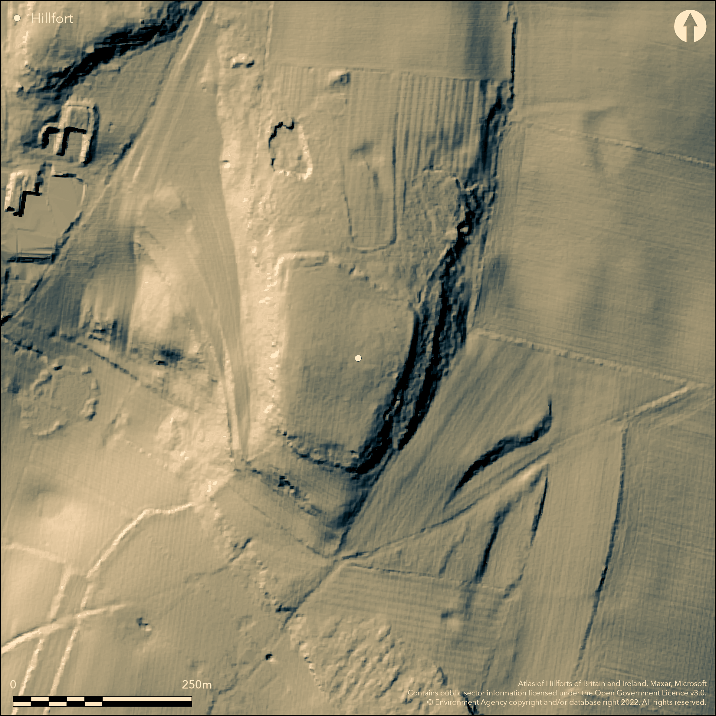
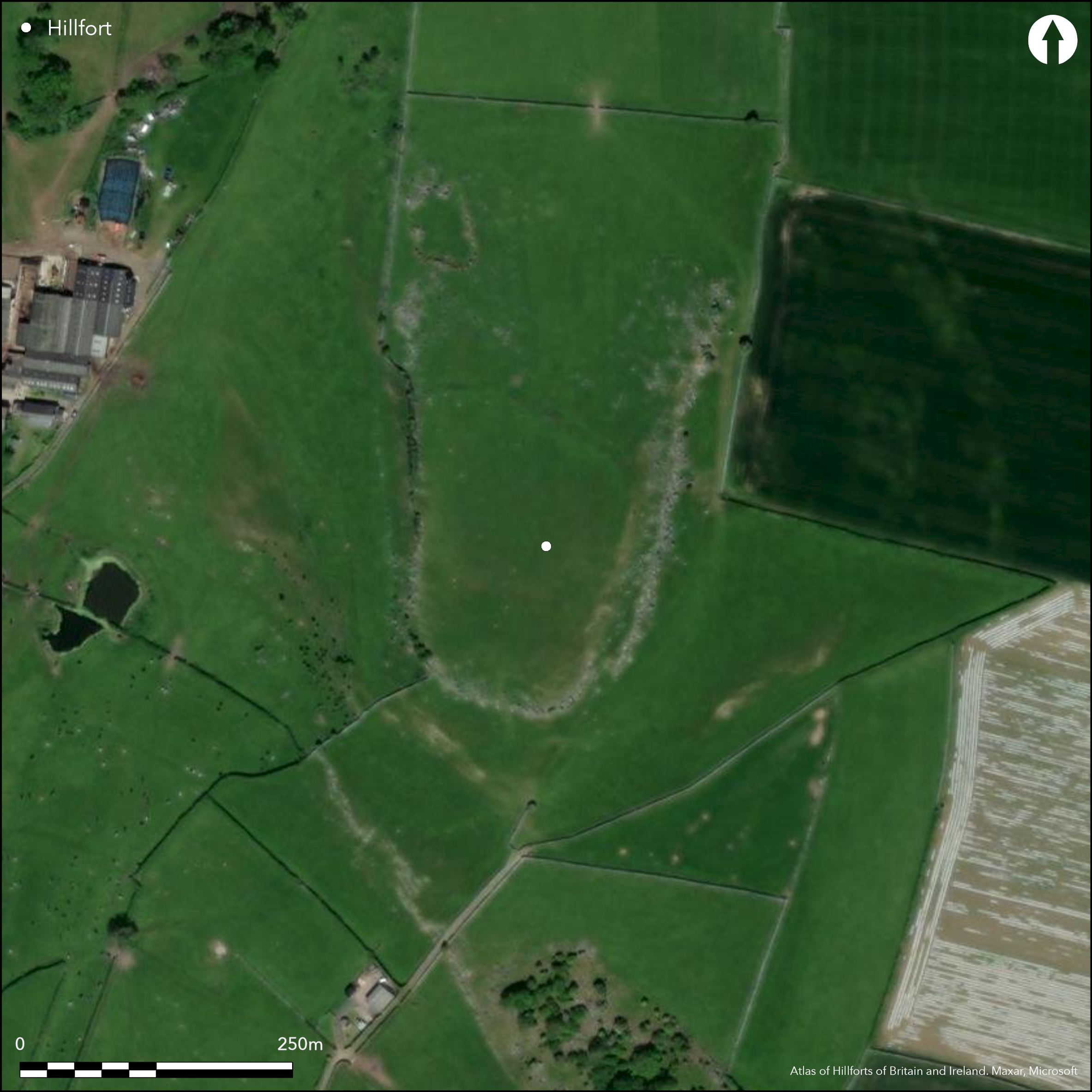
To the N of Great Urswick, a late Bronze Age or early Iron Age palisaded hilltop enclosure, succeeded by a slight univallate hillfort on the low, flat summit of Skelmore Heads. Rectilinear in form, it measures 143m N-S by 106m E-W, with an enclosed area of 1.7ha. A low earth and rock dump rampart and partially infilled rock-cut ditch defend the site in the N, elsewhere it is protected by naturally steep slopes and limestone outcrops. Only traces of the palisade have been found and It is uncertain if it once enclosed the entire hilltop. A narrow, slightly offset entrance lies in the NW. No contemporary internal features are known. The hillfort was excavated by Liverpool University in 1957 and 1959-60 (Powell et al. 1963) which revealed the earth and stone `dump' construction for the rampart, defined at the edges by postholes for vertical strengthening timbers. A palisade trench 20cm deep and 38-46cm wide was seen about 1.3m N of the face of the rampart and also within the SE corner of the fort. Finds from and near the site included pottery of a Bronze Age type, six socketed bronze axes, a saddle quern and a number of roughed out stone axes. The hillfort lies on what might have been one of the routes by which Langdale axes were transported south and could have earlier, Neolithic origins. Recorded on 1969-70 1:2,500 OS mapping.
Citizen Science: ✗
Reliability of Data: Confirmed
Reliability of Interpretation: Confirmed
X: -346532 Y: 7201886 (EPSG: 3857)
Longitude: -3.1129482818379874 Latitude: 54.167203690020976 (EPSG:4326)
Country: England
Current County or Unitary Authority: Cumbria
Historic County: Lancashire
Current Parish/Community/Council/Townland: Urswick
The bank is now low and the ditch partially infilled
| Extant | ✓ |
| Cropmark | ✗ |
| Likely Destroyed | ✗ |
Grassland
| Woodland | ✗ |
| Commercial Forestry Plantation | ✗ |
| Parkland | ✗ |
| Pasture (Grazing) | ✗ |
| Arable | ✗ |
| Scrub/Bracken | ✗ |
| Bare Outcrop | ✗ |
| Heather/Moorland | ✗ |
| Heath | ✗ |
| Built-up | ✗ |
| Coastal Grassland | ✗ |
| Other | ✓ |
A contour fort on the summit of a low, flat topped hill at 95m OD. From the summit there are extensive views in most directions expect in the SE where it is overlooked by Birkrigg Common.
| Contour Fort | ✓ |
| Partial Contour Fort | ✗ |
| Promontory Fort | ✗ |
| Hillslope Fort | ✗ |
| Level Terrain Fort | ✗ |
| Marsh Fort | ✗ |
| Multiple Enclosure Fort | ✗ |
| Hilltop | ✓ |
| Coastal Promontory | ✗ |
| Inland Promontory | ✗ |
| Valley Bottom | ✗ |
| Knoll/Hillock/Outcrop | ✗ |
| Ridge | ✗ |
| Cliff/Plateau-edge/Scarp | ✗ |
| Hillslope | ✗ |
| Lowland | ✗ |
| Spur | ✗ |
Dominant Topographic Feature: Summit of a low flat-topped hill
| North | ✗ |
| Northeast | ✗ |
| East | ✗ |
| Southeast | ✗ |
| South | ✗ |
| Southwest | ✗ |
| West | ✗ |
| Northwest | ✗ |
| Level | ✓ |
Altitude: 95.0m
N/A
Artefactual evidence indicates that human activity at this site and in the vicinity possibly pre-dates the fortification of the hilltop. Finds from and near the site included pottery of a Bronze Age type, six socketed bronze axes, a saddle quern and a number of roughed out stone axes. The hillfort lies on what might have been one of the routes by which Langdale axes were transported south and could have earlier, Neolithic origins. There is no evidence for occupation continuing beyond the 5th century BC.
Reliability: C - Low
| Pre 1200BC | ✗ |
| 1200BC - 800BC | ✓ |
| 800BC - 400BC | ✓ |
| 400BC - AD50 | ✓ |
| AD50 - AD400 | ✗ |
| AD400 - AD 800 | ✗ |
| Post AD800 | ✗ |
| Unknown | ✗ |
| Pre Hillfort: | None |
| Post Hillfort: | None |
| Artefactual: | Neolithic and Bronze Age finds recovered |
OS Field investigation in 1958 and 1967. Excavations carried out by Liverpool University in 1957 and 1959-1960 (Powell et al. 1963). Recorded on 1969-70 1:2,500 OS mapping. Scheduled
| Other (1958): | Field investigation |
| Other (1964): | Scheduled |
| Other (1967): | Field investigation |
| Excavation (None): | Limited excavation across the ramparts |
| 1st Identified Map Depiction (None): | None |
No evidence for internal features, a range of Neolithic and Bronze Age finds.
Small modern dew pond in use in 19th and 20th centuries
| None | ✗ |
| Spring | ✗ |
| Stream | ✗ |
| Pool | ✗ |
| Flush | ✗ |
| Well | ✗ |
| Other | ✓ |
None
| No Known Features | ✓ |
| Round Stone Structures | ✗ |
| Rectangular Stone Structures | ✗ |
| Curvilinear Platforms | ✗ |
| Other Roundhouse Evidence | ✗ |
| Pits | ✗ |
| Quarry Hollows | ✗ |
| Other | ✗ |
No internal structures were discovered contemporary with the occupation of the hillfort.
| No Known Excavation | ✗ |
| Pits | ✗ |
| Postholes | ✗ |
| Roundhouses | ✗ |
| Rectangular Structures | ✗ |
| Roads/Tracks | ✗ |
| Quarry Hollows | ✗ |
| Other | ✗ |
| Nothing Found | ✓ |
None
| No Known Geophysics | ✓ |
| Pits | ✗ |
| Roundhouses | ✗ |
| Rectangular Structures | ✗ |
| Roads/Tracks | ✗ |
| Quarry Hollows | ✗ |
| Other | ✗ |
| Nothing Found | ✗ |
Flint arrowhead and scraper and modern pottery discovered during excavation. Two further fragments of pottery, possibly Bronze Age were also recovered. Within the vicinity of the hillfort, six socketed bronze axes, a saddle quern and a number of roughed out stone axes were recovered. Four of the stone axes had been deliberately hidden
| No Known Finds | ✗ |
| Pottery | ✓ |
| Metal | ✓ |
| Metalworking | ✓ |
| Human Bones | ✗ |
| Animal Bones | ✗ |
| Lithics | ✓ |
| Environmental | ✗ |
| Other | ✗ |
None
| APs Not Checked | ✓ |
| None | ✗ |
| Roundhouses | ✗ |
| Rectangular Structures | ✗ |
| Pits | ✗ |
| Postholes | ✗ |
| Roads/Tracks | ✗ |
| Other | ✗ |
A causeway across the ditch in in the NW leads to a 2.1m wide entrance through the bank, which provides access to the interior.
| 1: | None |
| 2: | None |
Guard Chambers: ✗
Chevaux de Frise: ✗
| 1. Simple Gap (North west): | None |
The northern defences consisted of a bank of earth and stone approximately 3.7m wide and a ditch up to 3.4m wide and 1.2m deep. A number of postholes found near the entrance suggest a timber revetment was used to secure the bank. A row of hollows along the N and in the SE corner between the bank and ditch were interpreted through excavation as a trench for an earlier timber palisade. The palisade trench where excavated was found to be rectangular in section measuring approximately 0.5m wide and 0.2m deep.
| Area 1: | 1.7ha. |
| Total: | 1.7ha. |
Total Footprint Area: Noneha.
The northern defences consisted of a bank of earth and stone approximately 3.7m wide and a ditch up to 3.4m wide and 1.2m deep. A causeway across the ditch leads to an 2.1m wide entrance through the bank, which provides access to the interior. A number of postholes were found near the entrance suggesting a timber revetment was used to secure the bank. A row of hollows along the north and in the south-east corner between the bank and ditch, were interpreted through excavation as a trench for an earlier timber palisade, The trench where excavated, was found to be rectangular in section measuring approximately 0.5m wide and 0.2m deep.
| ✓ | None |
| ✗ | Only in the N |
| NE Quadrant: | 1 |
| SE Quadrant: | None |
| SW Quadrant: | None |
| NW Quadrant: | 1 |
| Total: | 1 |
| Partial Univallate | ✓ |
| Univallate | ✗ |
| Partial Bivallate | ✗ |
| Bivallate | ✗ |
| Partial Multivallate | ✗ |
| Multivallate | ✗ |
| Unknown | ✗ |
| Partial Univallate | ✗ |
| Univallate | ✗ |
| Partial Bivallate | ✗ |
| Bivallate | ✗ |
| Partial Multivallate | ✗ |
| Multivallate | ✗ |
Earth and heaped stones
| None | ✗ |
| Earthen Bank | ✓ |
| Stone Wall | ✗ |
| Rubble | ✓ |
| Wall-walk | ✗ |
| Evidence of Timber | ✗ |
| Vitrification | ✗ |
| Other Burning | ✗ |
| Palisade | ✗ |
| Counter Scarp Bank | ✗ |
| Berm | ✗ |
| Unfinished | ✗ |
| Other | ✗ |
Earth and stone bank with possible earlier pallisade. The discovery of postholes near the entrance suggest a timber revetment was used to secure the bank.
| None | ✗ |
| Earthen Bank | ✓ |
| Stone Wall | ✗ |
| Murus Duplex | ✗ |
| Timber-framed | ✓ |
| Timber-laced | ✗ |
| Vitrification | ✗ |
| Other Burning | ✗ |
| Palisade | ✓ |
| Counter Scarp Bank | ✗ |
| Berm | ✗ |
| Unfinished | ✗ |
| No Known Excavation | ✗ |
| Other | ✗ |
| ✗ | None |
| ✓ | None |
Number of Ditches: 1
| ✗ | None |
Hogg, A.H.A., 1979. British Hill-Forts. An Index. British Archaeological Reports, British Series 62.
Powell, T.G.E.1963. Excavations at Skelmore Heads near Ulverston, 1957 & 1959. Trans Cumberland Westmorland Antiq Archaeol Soc 3 1963; 4-20. plans and illustrations
Atlas of Hillforts:
Wikidata:
This work is licensed under CC BY-SA 4.0![]()
![]()
![]() and should be cited as:
and should be cited as:
Lock, Gary and Ralston, Ian. 2024. Atlas of Hillforts of Britain and Ireland. Available at: https://hillforts.arch.ox.ac.uk
Document Version 1.1