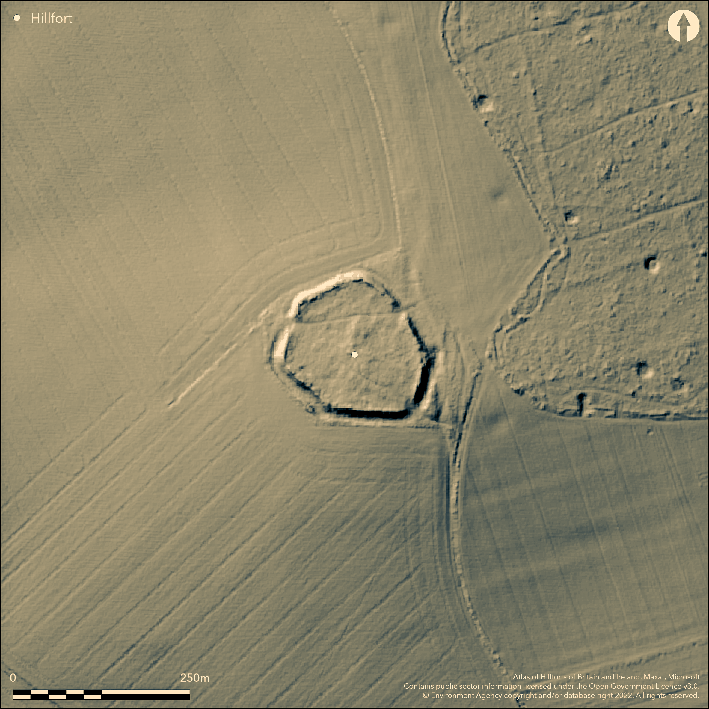
LiDAR 1m DTM Hillshade
Satellite Imagery
LiDAR 1m DTM Hillshade
Satellite Imagery
Scroll left/right to view further images.
HER: Oxfordshire 7333 (MOX44)
NMR: SU 28 SE 10 (225540)
SM: 1015551
NGR: SU 2773 8223
X: 427735 Y: 182235 (OSGB36)
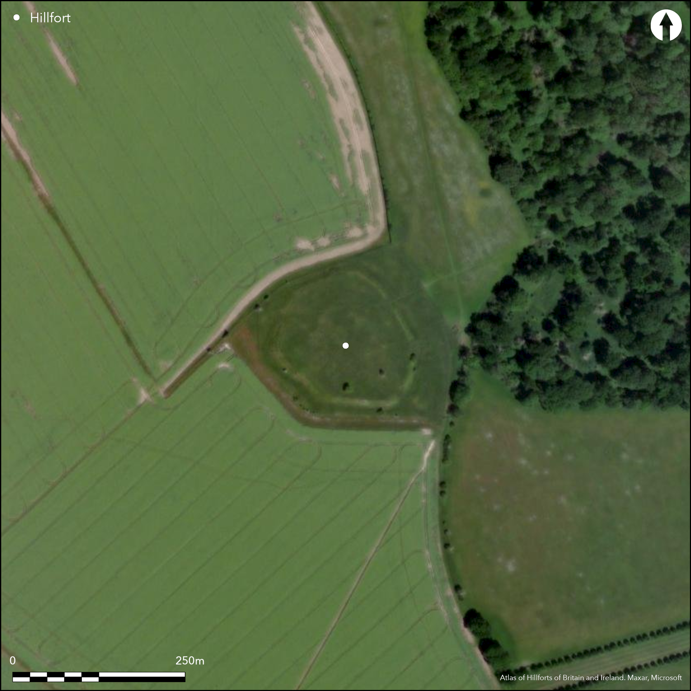
Situated in a large natural 'bowl' overlooked by hills with the Ridgeway to the N, just to the west of Ashdown House (National Trust) consisting of an extant small enclosure, 1.2ha, and a ploughed-out large annex enclosure to the N, approximately 4.1ha. A long history of recognition from Aubrey (17th century) onwards, see Gosden and Lock (2013). The small enclosure is univallate with a good surviving rampart and ditch, approximately hexagonal, three breaks through the rampart at the NE (unknown date), SE (Romano-British) and NW (Iron Age). Geophysics (Payne et. al. 2006) and excavation (Gosden and Lock 2013) have shown occupation within the small enclosure concentrating within the 5th-3rd centuries BC (C14 and archaeo-magnetic dates and pottery), roundhouses, pits, material culture and environmental evidence, plus a Romano-British farmhouse dating to 1st-3rd centuries AD. Pre-dating the hillfort are early Bronze Age round barrows and late Bronze Age linear ditches. The large enclosure seems to have been of a less substantial construction, perhaps an annex for livestock.
Citizen Science: ✓
Reliability of Data: Confirmed
Reliability of Interpretation: Confirmed
X: -178279 Y: 6717069 (EPSG: 3857)
Longitude: -1.6015113519614796 Latitude: 51.53829025422286 (EPSG:4326)
Country: England
Current County or Unitary Authority: Oxfordshire
Historic County: Berkshire
Current Parish/Community/Council/Townland: Ashbury
None
| Extant | ✓ |
| Cropmark | ✗ |
| Likely Destroyed | ✗ |
Small enclosure is extant earthwork (National Trust and pasture), large enclosure is ploughed out and visible as a cropmark.
| Woodland | ✗ |
| Commercial Forestry Plantation | ✗ |
| Parkland | ✗ |
| Pasture (Grazing) | ✓ |
| Arable | ✓ |
| Scrub/Bracken | ✗ |
| Bare Outcrop | ✗ |
| Heather/Moorland | ✗ |
| Heath | ✗ |
| Built-up | ✗ |
| Coastal Grassland | ✗ |
| Other | ✗ |
On slight hillock within a large 'bowl' surrounded by higher hills
| Contour Fort | ✗ |
| Partial Contour Fort | ✗ |
| Promontory Fort | ✗ |
| Hillslope Fort | ✗ |
| Level Terrain Fort | ✓ |
| Marsh Fort | ✗ |
| Multiple Enclosure Fort | ✗ |
On slight hillock within a large 'bowl' surrounded by higher hills
| Hilltop | ✗ |
| Coastal Promontory | ✗ |
| Inland Promontory | ✗ |
| Valley Bottom | ✗ |
| Knoll/Hillock/Outcrop | ✗ |
| Ridge | ✗ |
| Cliff/Plateau-edge/Scarp | ✗ |
| Hillslope | ✗ |
| Lowland | ✓ |
| Spur | ✗ |
Dominant Topographic Feature: Very visible location from surrounding hills.
| North | ✗ |
| Northeast | ✗ |
| East | ✗ |
| Southeast | ✗ |
| South | ✗ |
| Southwest | ✗ |
| West | ✗ |
| Northwest | ✗ |
| Level | ✓ |
Altitude: 190.0m
N/A
Pre-enclosure activity (EBA round barrows, LBA linear ditches). Small enclosure mainly 5th-3rd century BC, minimal LIA activity. Romano-British farmhouse 1st-3rd centuries AD, some Late Saxon activity 9th-11th centuries AD. 24 C14 dates, archaeo-magnetic, pottery and La tene brooch. Horn (Forthcoming) suggests the hillfort start 400-360 BC, ends 350-185 BC, span = 15-155 years.
Reliability: A - High
| Pre 1200BC | ✗ |
| 1200BC - 800BC | ✗ |
| 800BC - 400BC | ✗ |
| 400BC - AD50 | ✓ |
| AD50 - AD400 | ✗ |
| AD400 - AD 800 | ✗ |
| Post AD800 | ✗ |
| Unknown | ✗ |
| Pre Hillfort: | None |
| Post Hillfort: | None |
| Artefactual: | a good pottery typology |
| C14: | a good suite of 24 dates |
Long history of recognition from Aubrey (17th century) onwards, see Gosden and Lock (2013). Geophysics by English Heritage in 1996/98/99 (Payne et. al. 2006), major excavations 1998-2000 (Gosden and Lock 2013)
| 1st Identified Map Depiction (1762): | John Roque map |
| Other (2003): | Visited by Hillfort Study Group |
| 1st Identified Written Reference (None): | Aubrey (Monumenta Britannica) |
| Geophysical Survey (None): | Payne et. al. 2006 |
| Excavation (None): | Gosden and Lock 2013 |
Excavations have shown intensive occupation dating to 5th-3rd centuries BC, roundhouses, pits, all major groups of artefacts, environmental evidence. Romano-British re-use by stone built farmhouse. 1st-3rd centuries AD.
None obvious
| None | ✓ |
| Spring | ✗ |
| Stream | ✗ |
| Pool | ✗ |
| Flush | ✗ |
| Well | ✗ |
| Other | ✗ |
Nothing obvious
| No Known Features | ✓ |
| Round Stone Structures | ✗ |
| Rectangular Stone Structures | ✗ |
| Curvilinear Platforms | ✗ |
| Other Roundhouse Evidence | ✗ |
| Pits | ✗ |
| Quarry Hollows | ✗ |
| Other | ✗ |
Excavations have shown intensive occupation dating to 5th-3rd centuries BC, roundhouses, pits, postholes
| No Known Excavation | ✗ |
| Pits | ✓ |
| Postholes | ✓ |
| Roundhouses | ✓ |
| Rectangular Structures | ✓ |
| Roads/Tracks | ✗ |
| Quarry Hollows | ✗ |
| Other | ✓ |
| Nothing Found | ✗ |
Magnetometry, resistivity and GPR all failed to show any features due to depth and character of the overburden
| No Known Geophysics | ✗ |
| Pits | ✗ |
| Roundhouses | ✗ |
| Rectangular Structures | ✗ |
| Roads/Tracks | ✗ |
| Quarry Hollows | ✗ |
| Other | ✓ |
| Nothing Found | ✗ |
Extensive finds from excavations, all major categories
| No Known Finds | ✗ |
| Pottery | ✓ |
| Metal | ✓ |
| Metalworking | ✓ |
| Human Bones | ✓ |
| Animal Bones | ✓ |
| Lithics | ✓ |
| Environmental | ✓ |
| Other | ✓ |
None
| APs Not Checked | ✗ |
| None | ✓ |
| Roundhouses | ✗ |
| Rectangular Structures | ✗ |
| Pits | ✗ |
| Postholes | ✗ |
| Roads/Tracks | ✗ |
| Other | ✗ |
NW entrance from small enclosure into the large enclosure is Iron Age. NE entrance unknown if original. SE entrance is Romano-British to provide access to farmhouse in the centre of the enclosure. No entrances for the large enclosure are known.
| 3: | None |
| 2: | None |
Guard Chambers: ✗
Chevaux de Frise: ✗
| 1. Simple Gap (North east): | Simple gap, not excavated |
| 2. Simple Gap (North west): | Simple gap, excavated, Iron Age |
Single rampart and ditch around complete circuit, in short straight lengths producing a roughly hexagonal plan
| Area 1: | 1.2ha. |
| Total: | 1.2ha. |
Total Footprint Area: 5.3ha.
None
| ✗ | None |
| ✓ | None |
| NE Quadrant: | 1 |
| SE Quadrant: | 1 |
| SW Quadrant: | 1 |
| NW Quadrant: | 1 |
| Total: | 1 |
| Partial Univallate | ✗ |
| Univallate | ✓ |
| Partial Bivallate | ✗ |
| Bivallate | ✗ |
| Partial Multivallate | ✗ |
| Multivallate | ✗ |
| Unknown | ✗ |
| Partial Univallate | ✗ |
| Univallate | ✗ |
| Partial Bivallate | ✗ |
| Bivallate | ✗ |
| Partial Multivallate | ✗ |
| Multivallate | ✗ |
Blocks of sarsen within the rampart
| None | ✗ |
| Earthen Bank | ✓ |
| Stone Wall | ✓ |
| Rubble | ✗ |
| Wall-walk | ✗ |
| Evidence of Timber | ✗ |
| Vitrification | ✗ |
| Other Burning | ✗ |
| Palisade | ✗ |
| Counter Scarp Bank | ✗ |
| Berm | ✗ |
| Unfinished | ✗ |
| Other | ✗ |
Front face of sarsen rows, revetted by chalk bank behind
| None | ✗ |
| Earthen Bank | ✓ |
| Stone Wall | ✓ |
| Murus Duplex | ✗ |
| Timber-framed | ✗ |
| Timber-laced | ✗ |
| Vitrification | ✗ |
| Other Burning | ✗ |
| Palisade | ✗ |
| Counter Scarp Bank | ✗ |
| Berm | ✗ |
| Unfinished | ✗ |
| No Known Excavation | ✗ |
| Other | ✗ |
| ✗ | None |
| ✓ | Single ditch around the small enclosure, V-shaped c.4m deep |
Number of Ditches: 1
| ✓ | The annex is attached to the N, single bank and ditch (now completely ploughed away but visible on aerial photographs), no obvious entrances but the NW entrance of the small enclosure joins the two. Limited excavation revealed very few features internally, perhaps for livestock? |
Gosden, C. and Lock, G. 2013. Histories in the making. Excavations at Alfred's Castle 1998-2000. Oxford University, School of Archaeology Monograph 79.
Horn, J. Forthcoming. The dating of hillforts in Britain and Ireland. Unpublished PhD thesis, University of Edinburgh.
Payne, A., Corney, M. and Cunliffe B 2006. The Wessex Hillforts Project. Extensive Survey of Hillforts in Central Southern England. English Heritage, 81-88.
Atlas of Hillforts:
Wikidata:
This work is licensed under CC BY-SA 4.0![]()
![]()
![]() and should be cited as:
and should be cited as:
Lock, Gary and Ralston, Ian. 2024. Atlas of Hillforts of Britain and Ireland. Available at: https://hillforts.arch.ox.ac.uk
Document Version 1.1