LiDAR 1m DTM Hillshade
Satellite Imagery
LiDAR 1m DTM Hillshade
Satellite Imagery
Scroll left/right to view further images.
HER: Oxfordshire 1940 (MOX70)
NMR: SU 67 NW 21 (241336)
SM: 1003704
NGR: SU 6431 7825
X: 464350 Y: 178250 (OSGB36)
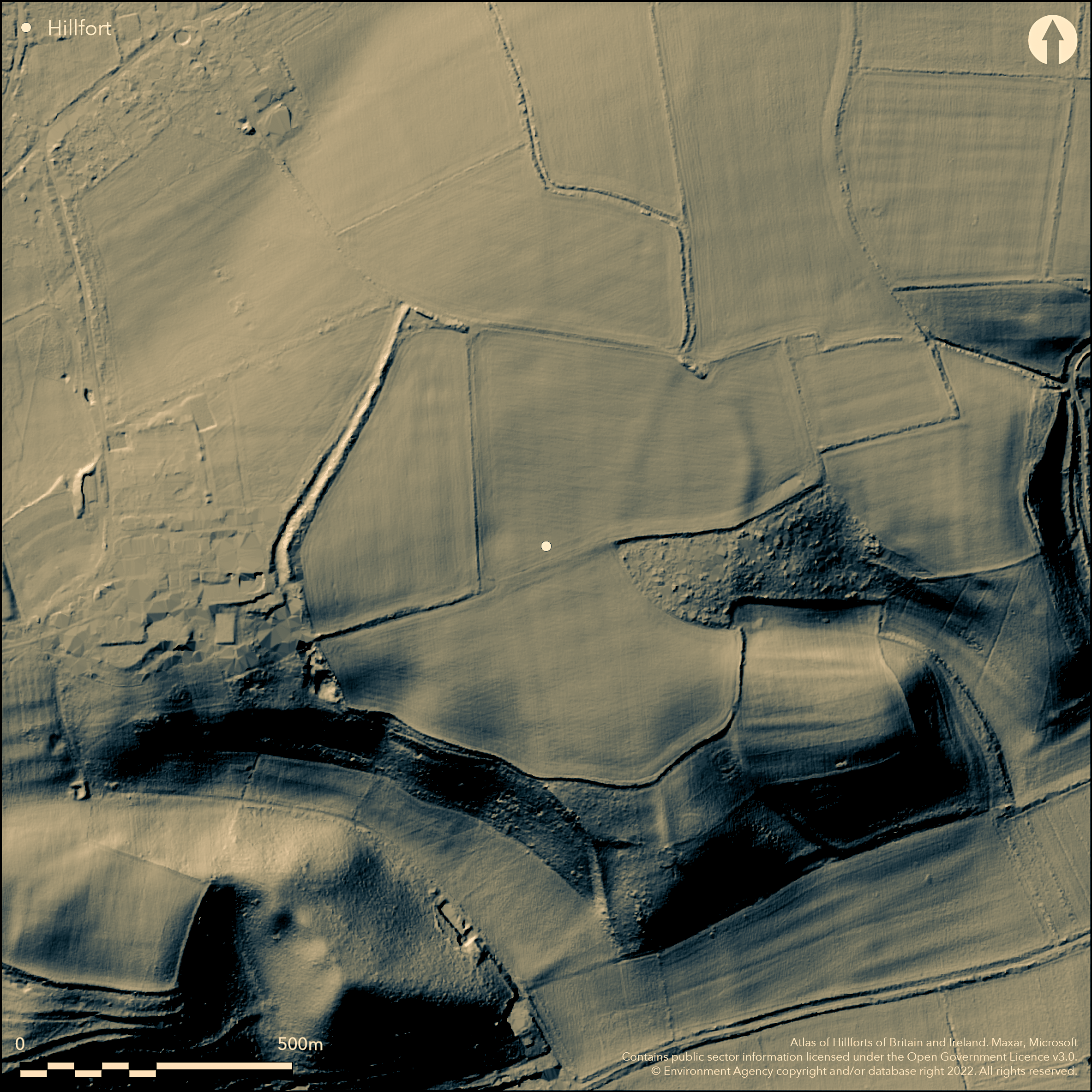
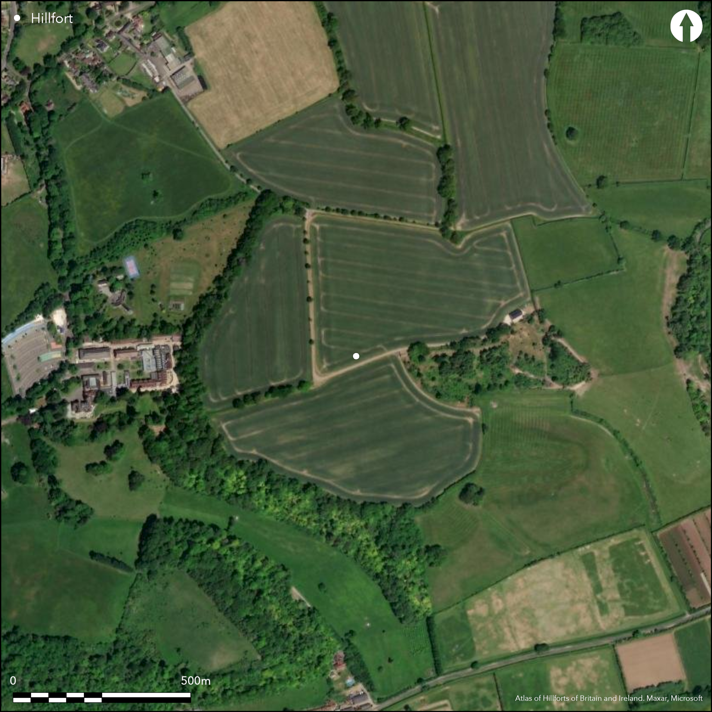
To the N of Whitchurch-on-Thames, a roughly circular enclosure whose S side makes use of the steep scarp overlooking the River Thames. On 2nd Ed. OS map (1937-61). Encloses c. 28.5ha although much of the E and S ramparts are destroyed by ploughing. Univallate with a ditch, possible counterscarp bank survives to the W and NW where the ramparts are best preserved within woodland c.2m high, ditch shown to be c.3.5m deep by small-scale excavation (Wood 1954). Breaks through the N and W are probably not original, it is suggested by the excavator that the original entrance may have been at the head of a dry valley to the E where only small lengths of rampart survive. Early Iron Age pottery from the ditch excavation. Subsequent small-scale excavation close to the ditch at the W revealed a late Bronze Age ditch which may be part of an enclosure which was a precursor to the hillfort.
Citizen Science: ✓
Reliability of Data: Confirmed
Reliability of Interpretation: Confirmed
X: -119597 Y: 6710127 (EPSG: 3857)
Longitude: -1.0743552889771715 Latitude: 51.49948295010118 (EPSG:4326)
Country: England
Current County or Unitary Authority: Oxfordshire
Historic County: Berkshire
Current Parish/Community/Council/Townland: Whitchurch-on-Thames
On Heritage at Risk Register (2015).
| Extant | ✓ |
| Cropmark | ✗ |
| Likely Destroyed | ✗ |
Badly damaged by ploughing and tree cover, some quarrying of the southern ramparts, best preserved run of rampart is in the NW. Interior and much of the rampart under arable.
| Woodland | ✓ |
| Commercial Forestry Plantation | ✗ |
| Parkland | ✗ |
| Pasture (Grazing) | ✗ |
| Arable | ✓ |
| Scrub/Bracken | ✗ |
| Bare Outcrop | ✗ |
| Heather/Moorland | ✗ |
| Heath | ✗ |
| Built-up | ✗ |
| Coastal Grassland | ✗ |
| Other | ✗ |
Follows a slight hill on a slope. Utilises the chalk scarp to the S overlooking the River Thames and sloping towards it, altitude at NW is 131m, at S edge is 99m
| Contour Fort | ✗ |
| Partial Contour Fort | ✓ |
| Promontory Fort | ✗ |
| Hillslope Fort | ✓ |
| Level Terrain Fort | ✗ |
| Marsh Fort | ✗ |
| Multiple Enclosure Fort | ✗ |
| Hilltop | ✗ |
| Coastal Promontory | ✗ |
| Inland Promontory | ✗ |
| Valley Bottom | ✗ |
| Knoll/Hillock/Outcrop | ✗ |
| Ridge | ✗ |
| Cliff/Plateau-edge/Scarp | ✓ |
| Hillslope | ✓ |
| Lowland | ✗ |
| Spur | ✗ |
Dominant Topographic Feature: Overlooks the River Thames to the S
| North | ✗ |
| Northeast | ✗ |
| East | ✗ |
| Southeast | ✗ |
| South | ✓ |
| Southwest | ✗ |
| West | ✗ |
| Northwest | ✗ |
| Level | ✗ |
Altitude: 115.0m
N/A
Early Iron Age (pottery and shale bracelet from excavation)
Reliability: B - Medium
| Pre 1200BC | ✗ |
| 1200BC - 800BC | ✗ |
| 800BC - 400BC | ✓ |
| 400BC - AD50 | ✗ |
| AD50 - AD400 | ✗ |
| AD400 - AD 800 | ✗ |
| Post AD800 | ✗ |
| Unknown | ✗ |
| Pre Hillfort: | None |
| Post Hillfort: | None |
| Artefactual: | Pottery from excavation (Wood 1954) |
On 2nd Ed. OS map (1937-61). Limited excavation of NE rampart (Wood 1954) and just outside the ditch (Howell 1995)
| Excavation (1954): | Wood 1954 |
| Excavation (1994): | Howell 1995 |
| 1st Identified Map Depiction (None): | 2nd Ed. OS |
No evidence for the interior
None obvious
| None | ✓ |
| Spring | ✗ |
| Stream | ✗ |
| Pool | ✗ |
| Flush | ✗ |
| Well | ✗ |
| Other | ✗ |
None
| No Known Features | ✓ |
| Round Stone Structures | ✗ |
| Rectangular Stone Structures | ✗ |
| Curvilinear Platforms | ✗ |
| Other Roundhouse Evidence | ✗ |
| Pits | ✗ |
| Quarry Hollows | ✗ |
| Other | ✗ |
None
| No Known Excavation | ✓ |
| Pits | ✗ |
| Postholes | ✗ |
| Roundhouses | ✗ |
| Rectangular Structures | ✗ |
| Roads/Tracks | ✗ |
| Quarry Hollows | ✗ |
| Other | ✗ |
| Nothing Found | ✗ |
None
| No Known Geophysics | ✓ |
| Pits | ✗ |
| Roundhouses | ✗ |
| Rectangular Structures | ✗ |
| Roads/Tracks | ✗ |
| Quarry Hollows | ✗ |
| Other | ✗ |
| Nothing Found | ✗ |
Pottery and a shale bracelet fragment from the ditch excavation
| No Known Finds | ✗ |
| Pottery | ✓ |
| Metal | ✗ |
| Metalworking | ✗ |
| Human Bones | ✗ |
| Animal Bones | ✗ |
| Lithics | ✗ |
| Environmental | ✗ |
| Other | ✓ |
None
| APs Not Checked | ✗ |
| None | ✓ |
| Roundhouses | ✗ |
| Rectangular Structures | ✗ |
| Pits | ✗ |
| Postholes | ✗ |
| Roads/Tracks | ✗ |
| Other | ✗ |
Original entrance is unknow but supposed to be at the head of a dry valley in the E, only short lengths of ramparts survive in this area
| 3: | Gaps at W and NW probably not original |
| 2: | None |
Guard Chambers: ✗
Chevaux de Frise: ✗
| 1. Simple Gap (East): | Suggested at head of dry valley, no evidence |
Univallate with ditch, possible counterscarp bank which survives partially at the W
| Area 1: | 23.5ha. |
| Total: | 23.5ha. |
Total Footprint Area: Noneha.
Univallate with ditch, possible counterscarp bank which survives partially at the W
| ✗ | None |
| ✗ | They may have originally, the E and S sides are uncertain due to damage |
| NE Quadrant: | 1 |
| SE Quadrant: | 1 |
| SW Quadrant: | 0 |
| NW Quadrant: | 1 |
| Total: | 1 |
| Partial Univallate | ✓ |
| Univallate | ✗ |
| Partial Bivallate | ✗ |
| Bivallate | ✗ |
| Partial Multivallate | ✗ |
| Multivallate | ✗ |
| Unknown | ✗ |
| Partial Univallate | ✗ |
| Univallate | ✗ |
| Partial Bivallate | ✗ |
| Bivallate | ✗ |
| Partial Multivallate | ✗ |
| Multivallate | ✗ |
Earthen bank with counterscarp bank
| None | ✗ |
| Earthen Bank | ✓ |
| Stone Wall | ✗ |
| Rubble | ✗ |
| Wall-walk | ✗ |
| Evidence of Timber | ✗ |
| Vitrification | ✗ |
| Other Burning | ✗ |
| Palisade | ✗ |
| Counter Scarp Bank | ✓ |
| Berm | ✗ |
| Unfinished | ✗ |
| Other | ✗ |
Earthen bank with counterscarp bank
| None | ✗ |
| Earthen Bank | ✓ |
| Stone Wall | ✗ |
| Murus Duplex | ✗ |
| Timber-framed | ✗ |
| Timber-laced | ✗ |
| Vitrification | ✗ |
| Other Burning | ✗ |
| Palisade | ✗ |
| Counter Scarp Bank | ✓ |
| Berm | ✗ |
| Unfinished | ✗ |
| No Known Excavation | ✗ |
| Other | ✗ |
| ✗ | None |
| ✓ | Excavation (Wood 1954) through the NE rampart showed a V-section ditch c.3.5m deep |
Number of Ditches: 1
| ✗ | None |
Wood, P. 1954. The early Iron Age camp on Bozedown, Whitchurch, Oxon. Oxoniensia, 19, 8-14.
Howell, L. 1995. The Excavation of a Bronge Age Ditch at the Field Test Centre at Castrol Technology Centre, Pangbourne, Berkshire. Oxoniensia, 61, 35-9.
Atlas of Hillforts:
Wikidata:
This work is licensed under CC BY-SA 4.0![]()
![]()
![]() and should be cited as:
and should be cited as:
Lock, Gary and Ralston, Ian. 2024. Atlas of Hillforts of Britain and Ireland. Available at: https://hillforts.arch.ox.ac.uk
Document Version 1.1