LiDAR 1m DTM Hillshade
Satellite Imagery
LiDAR 1m DTM Hillshade
Satellite Imagery
Scroll left/right to view further images.
HER: Oxfordshire 7529 (MOX157)
NMR: SU 29 SE 3 (225919)
SM: 1002951
NGR: SU 2886 9281
X: 428850 Y: 192850 (OSGB36)
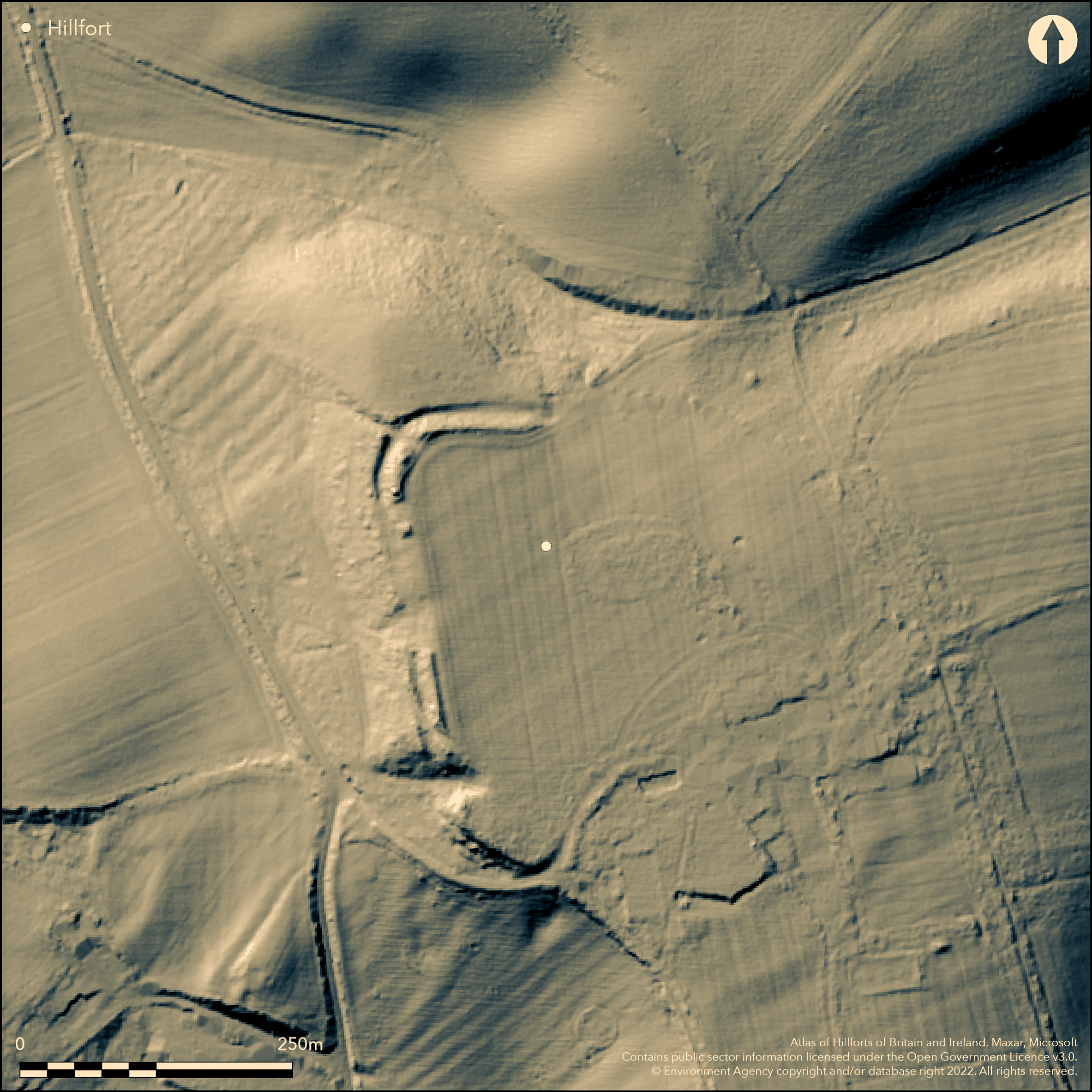
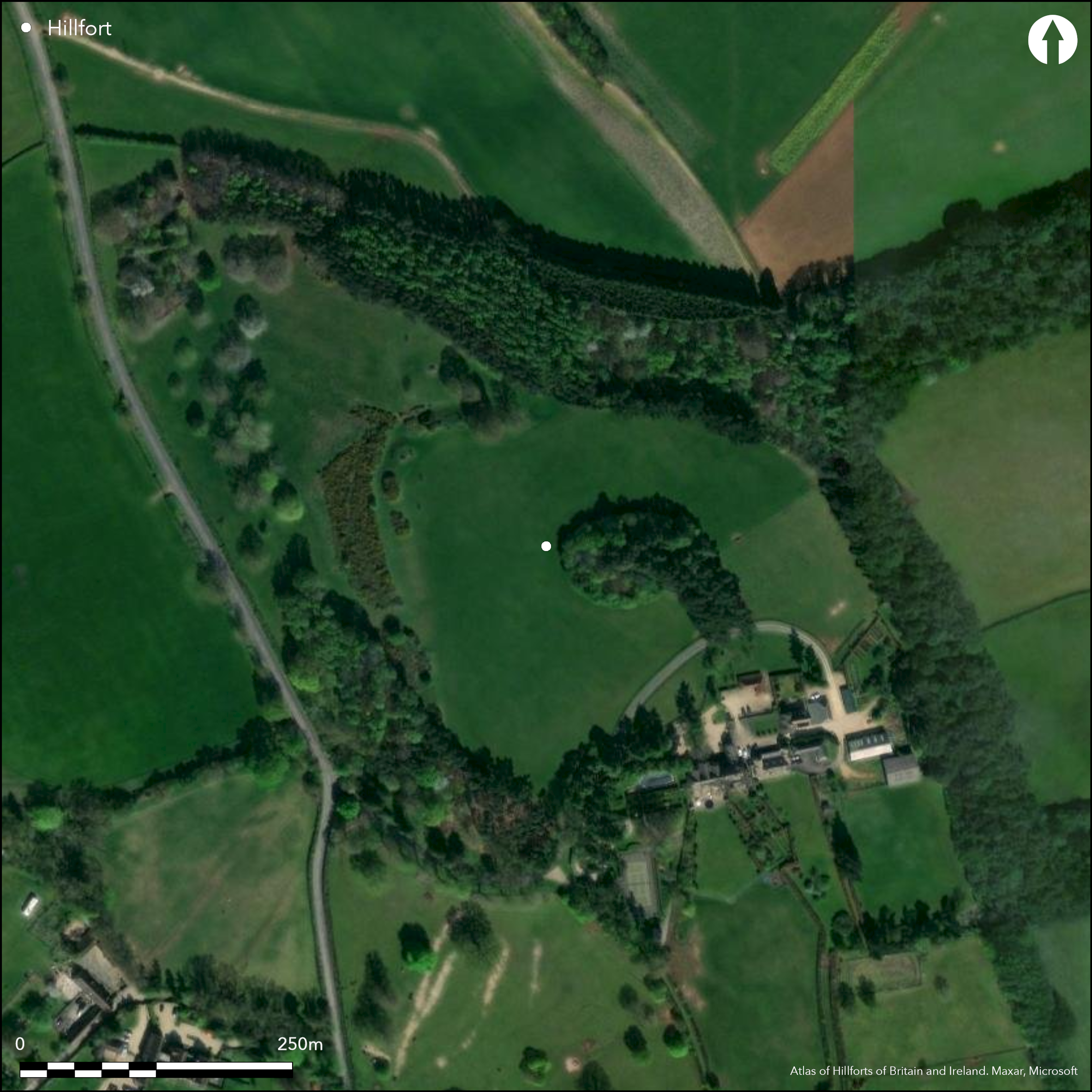
SW of Little Coxwell, a contour fort on Furze Hill with good views in all directions. Described by Aubrey (1665-1693) and in Lysons Magna Britannia (1813), on 2nd Ed. OS map. Univallate with a ditch, encloses 4.9ha, best preserved in NW where bank is c.12m wide, c.1.5m high and the ditch is 1.2m deep, bank destroyed in other areas, some tree cover and agricultural damage, house built over S part of site. Two possible entrances both approached by a hollow way, NW is a simple gap, SW is possibly out-turned. No interventions, Iron Age and Romano-British pottery found on the surface.
Citizen Science: ✗
Reliability of Data: Confirmed
Reliability of Interpretation: Confirmed
X: -176393 Y: 6734159 (EPSG: 3857)
Longitude: -1.5845655836458303 Latitude: 51.63367700390685 (EPSG:4326)
Country: England; None
Current County or Unitary Authority: Oxfordshire
Historic County: Berkshire
Current Parish/Community/Council/Townland: Little Coxwell; Fernham
None
| Extant | ✓ |
| Cropmark | ✗ |
| Likely Destroyed | ✗ |
Single bank and ditch best preserved at north and west, south eastern area destroyed by the building of a house. Stretches of rampart ploughed away.
| Woodland | ✓ |
| Commercial Forestry Plantation | ✗ |
| Parkland | ✗ |
| Pasture (Grazing) | ✗ |
| Arable | ✗ |
| Scrub/Bracken | ✓ |
| Bare Outcrop | ✗ |
| Heather/Moorland | ✗ |
| Heath | ✗ |
| Built-up | ✗ |
| Coastal Grassland | ✗ |
| Other | ✗ |
Follows the contour of hilltop, steep slopes to N and W, gentle to S and E
| Contour Fort | ✓ |
| Partial Contour Fort | ✗ |
| Promontory Fort | ✗ |
| Hillslope Fort | ✗ |
| Level Terrain Fort | ✗ |
| Marsh Fort | ✗ |
| Multiple Enclosure Fort | ✗ |
Follows the contour of hilltop
| Hilltop | ✓ |
| Coastal Promontory | ✗ |
| Inland Promontory | ✗ |
| Valley Bottom | ✗ |
| Knoll/Hillock/Outcrop | ✗ |
| Ridge | ✗ |
| Cliff/Plateau-edge/Scarp | ✗ |
| Hillslope | ✗ |
| Lowland | ✗ |
| Spur | ✗ |
Dominant Topographic Feature: Good views all around
| North | ✗ |
| Northeast | ✗ |
| East | ✗ |
| Southeast | ✗ |
| South | ✗ |
| Southwest | ✗ |
| West | ✗ |
| Northwest | ✗ |
| Level | ✓ |
Altitude: 128.0m
Boundary Type: Parish/Townland
Surface finds of Iron Age and Roman pottery on southern rampart
Reliability: D - None
| Pre 1200BC | ✗ |
| 1200BC - 800BC | ✗ |
| 800BC - 400BC | ✓ |
| 400BC - AD50 | ✓ |
| AD50 - AD400 | ✓ |
| AD400 - AD 800 | ✗ |
| Post AD800 | ✗ |
| Unknown | ✗ |
| Pre Hillfort: | None |
| Post Hillfort: | None |
| Artefactual: | surface pottery |
In Aubrey's Monumenta Britannica (1665-1693). Described in Lysons Magna Britannia (1813), on 2nd Ed. OS map. No excavation. Surface finds of pottery.
| 1st Identified Written Reference (None): | None |
| 1st Identified Map Depiction (None): | 2nd Ed. OS |
Surface finds of Iron Age and Romano-British pottery
None
| None | ✓ |
| Spring | ✗ |
| Stream | ✗ |
| Pool | ✗ |
| Flush | ✗ |
| Well | ✗ |
| Other | ✗ |
None
| No Known Features | ✓ |
| Round Stone Structures | ✗ |
| Rectangular Stone Structures | ✗ |
| Curvilinear Platforms | ✗ |
| Other Roundhouse Evidence | ✗ |
| Pits | ✗ |
| Quarry Hollows | ✗ |
| Other | ✗ |
None
| No Known Excavation | ✓ |
| Pits | ✗ |
| Postholes | ✗ |
| Roundhouses | ✗ |
| Rectangular Structures | ✗ |
| Roads/Tracks | ✗ |
| Quarry Hollows | ✗ |
| Other | ✗ |
| Nothing Found | ✗ |
None
| No Known Geophysics | ✓ |
| Pits | ✗ |
| Roundhouses | ✗ |
| Rectangular Structures | ✗ |
| Roads/Tracks | ✗ |
| Quarry Hollows | ✗ |
| Other | ✗ |
| Nothing Found | ✗ |
Surface finds of Iron Age and Romano-British pottery
| No Known Finds | ✗ |
| Pottery | ✓ |
| Metal | ✗ |
| Metalworking | ✗ |
| Human Bones | ✗ |
| Animal Bones | ✗ |
| Lithics | ✗ |
| Environmental | ✗ |
| Other | ✗ |
None
| APs Not Checked | ✓ |
| None | ✗ |
| Roundhouses | ✗ |
| Rectangular Structures | ✗ |
| Pits | ✗ |
| Postholes | ✗ |
| Roads/Tracks | ✗ |
| Other | ✗ |
Two possible entrances, south-west and north-west, both approached by hollow ways. NW simple, SW possibly out-turned.
| None: | Unknown as rampart circuit isn't complete due to damage |
| 2: | None |
Guard Chambers: ✗
Chevaux de Frise: ✗
| 1. Simple Gap (North west): | simple, approached by hollow way |
| 1. Hollow Way (North west): | None |
| 2. Out-turned (South west): | possibly out-turned, approached by hollow way |
| 2. Hollow Way (South west): | None |
Single bank and ditch, best preserved in NW where bank is c.12m wide, c.1.5m high and the ditch is 1.2m deep.
| Area 1: | 4.9ha. |
| Total: | 4.9ha. |
Total Footprint Area: Noneha.
Single bank and ditch, best preserved in NW where bank is c.12m wide, c.1.5m high and the ditch is 1.2m deep.
| ✗ | None |
| ✗ | Probably did originally |
| NE Quadrant: | 1 |
| SE Quadrant: | 1 |
| SW Quadrant: | 1 |
| NW Quadrant: | 1 |
| Total: | 1 |
| Partial Univallate | ✗ |
| Univallate | ✓ |
| Partial Bivallate | ✗ |
| Bivallate | ✗ |
| Partial Multivallate | ✗ |
| Multivallate | ✗ |
| Unknown | ✗ |
| Partial Univallate | ✗ |
| Univallate | ✗ |
| Partial Bivallate | ✗ |
| Bivallate | ✗ |
| Partial Multivallate | ✗ |
| Multivallate | ✗ |
earthen bank
| None | ✗ |
| Earthen Bank | ✓ |
| Stone Wall | ✗ |
| Rubble | ✗ |
| Wall-walk | ✗ |
| Evidence of Timber | ✗ |
| Vitrification | ✗ |
| Other Burning | ✗ |
| Palisade | ✗ |
| Counter Scarp Bank | ✗ |
| Berm | ✗ |
| Unfinished | ✗ |
| Other | ✗ |
None
| None | ✓ |
| Earthen Bank | ✗ |
| Stone Wall | ✗ |
| Murus Duplex | ✗ |
| Timber-framed | ✗ |
| Timber-laced | ✗ |
| Vitrification | ✗ |
| Other Burning | ✗ |
| Palisade | ✗ |
| Counter Scarp Bank | ✗ |
| Berm | ✗ |
| Unfinished | ✗ |
| No Known Excavation | ✗ |
| Other | ✗ |
| ✗ | None |
| ✓ | Single ditch, c.1.2m deep in NW |
Number of Ditches: 1
| ✗ | None |
Cotton, M. A. 1962. Berkshire Hill Forts. Berkshire Archaeol J, 60, 30-52
Atlas of Hillforts:
Wikidata:
This work is licensed under CC BY-SA 4.0![]()
![]()
![]() and should be cited as:
and should be cited as:
Lock, Gary and Ralston, Ian. 2024. Atlas of Hillforts of Britain and Ireland. Available at: https://hillforts.arch.ox.ac.uk
Document Version 1.1