LiDAR 1m DTM Hillshade

Satellite Imagery
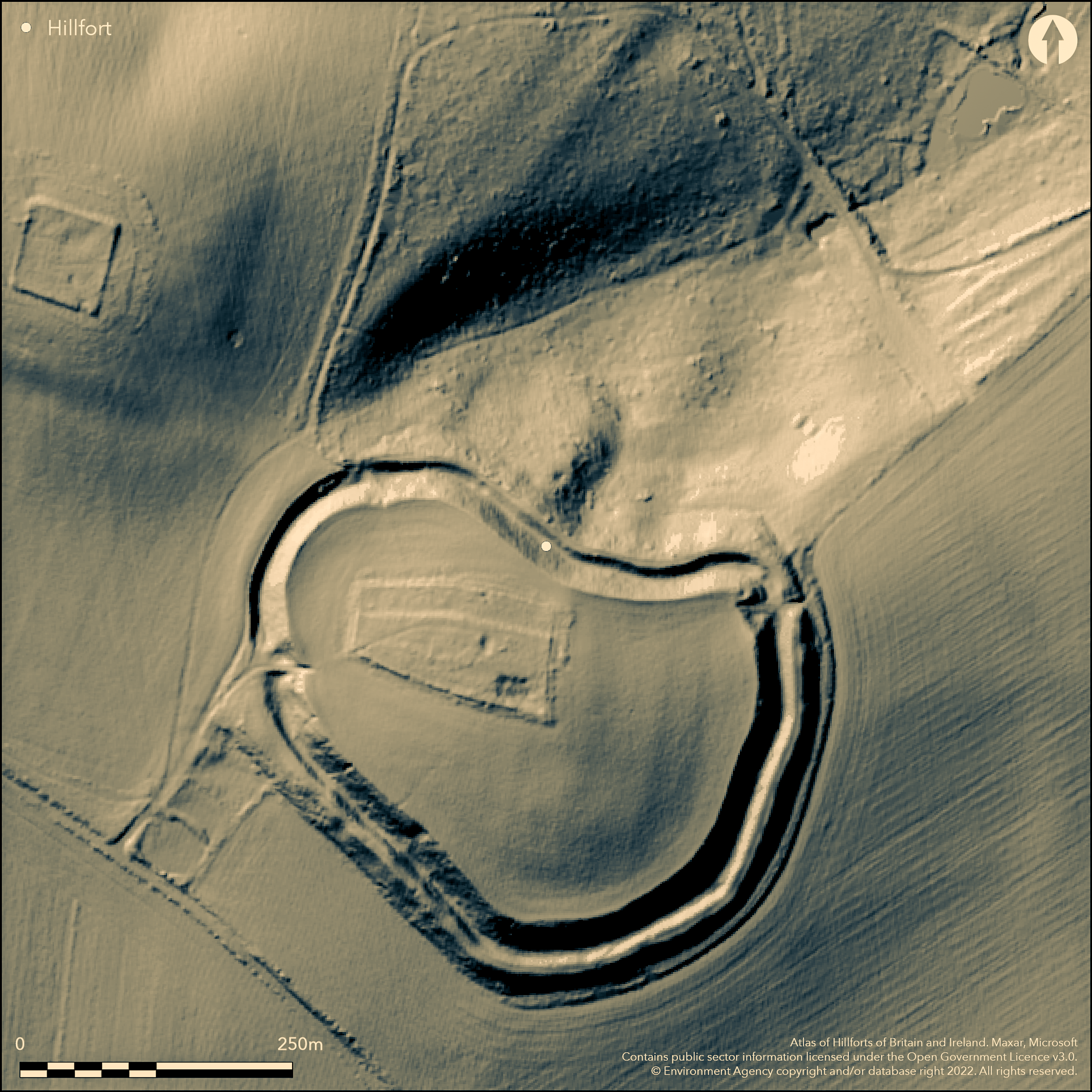
LiDAR 1m DTM Hillshade
Satellite Imagery
Scroll left/right to view further images.
HER: Oxfordshire 3153 (MOX158)
NMR: SU 59 SE 40 (238126)
SM: 1006302
NGR: SU 5695 9244
X: 456950 Y: 192550 (OSGB36)
W of Little Wittenham, a contour fort on Castle Hill with good views in all directions and overlooking the River Thames. Mentioned by Leland (1711), on 1st Ed. OS map. Univallate with ditch and counterscarp bank for the entire circuit, rampart is much denuded, mostly pasture but with tree cover in part of the interior and along the N side. Two possible entrances, NE could be inturned, SW possible outworks. Excavations and geophysics (Allen et. al. 2010) have shown evidence for occupation dating to early and middle Iron Age, also a late Bronze Age enclosure in the middle of the hillfort, late Romano-British re-use and medieval occupation. The report includes work on Iron Age and Romano-British sites and landscape around the hillfort.
Citizen Science: ✗
Reliability of Data: Confirmed
Reliability of Interpretation: Confirmed
X: -131205 Y: 6733292 (EPSG: 3857)
Longitude: -1.1786371332191647 Latitude: 51.62884172706301 (EPSG:4326)
Country: England
Current County or Unitary Authority: Oxfordshire
Historic County: Berkshire
Current Parish/Community/Council/Townland: Little Wittenham
None
| Extant | ✓ |
| Cropmark | ✗ |
| Likely Destroyed | ✗ |
Inner rampart eroded but ditch and counterscarp bank well preserved, mostly pasture, some tree cover in interior and on N and NE ramparts
| Woodland | ✓ |
| Commercial Forestry Plantation | ✗ |
| Parkland | ✗ |
| Pasture (Grazing) | ✓ |
| Arable | ✗ |
| Scrub/Bracken | ✓ |
| Bare Outcrop | ✗ |
| Heather/Moorland | ✗ |
| Heath | ✗ |
| Built-up | ✗ |
| Coastal Grassland | ✗ |
| Other | ✗ |
A contour fort on a prominent hilltop overlooking the River Thames with good views in all directions
| Contour Fort | ✓ |
| Partial Contour Fort | ✗ |
| Promontory Fort | ✗ |
| Hillslope Fort | ✗ |
| Level Terrain Fort | ✗ |
| Marsh Fort | ✗ |
| Multiple Enclosure Fort | ✗ |
A contour fort on a prominent hilltop overlooking the River Thames with good views in all directions
| Hilltop | ✓ |
| Coastal Promontory | ✗ |
| Inland Promontory | ✗ |
| Valley Bottom | ✗ |
| Knoll/Hillock/Outcrop | ✗ |
| Ridge | ✗ |
| Cliff/Plateau-edge/Scarp | ✗ |
| Hillslope | ✗ |
| Lowland | ✗ |
| Spur | ✗ |
Dominant Topographic Feature: Overlooks the River Thames, good views in all directions
| North | ✗ |
| Northeast | ✗ |
| East | ✗ |
| Southeast | ✗ |
| South | ✗ |
| Southwest | ✗ |
| West | ✗ |
| Northwest | ✗ |
| Level | ✓ |
Altitude: 107.0m
N/A
Late Bronze Age enclosure in the middle of the hillfort, identified by geophysics, hillfort dated to early and middle Iron Age through excavation and pottery, late Romano-British re-use (4th century), medieval occupation (12th/13th century)
Reliability: A - High
| Pre 1200BC | ✗ |
| 1200BC - 800BC | ✗ |
| 800BC - 400BC | ✓ |
| 400BC - AD50 | ✓ |
| AD50 - AD400 | ✓ |
| AD400 - AD 800 | ✗ |
| Post AD800 | ✓ |
| Unknown | ✗ |
| Pre Hillfort: | None |
| Post Hillfort: | None |
| Artefactual: | pottery |
Mentioned by Leland (1711), on 1st Ed. OS map. Excavations in 2003-6 by Oxford Archaeology (Allen et. al. 2010), across southern rampart and interior, 9 trenches. Geophysical survey of interior. Work on sites in surrounding landscape
| 1st Identified Written Reference (1711): | Leland |
| 1st Identified Map Depiction (None): | 1st Ed. OS |
| Excavation (None): | Allen et. al. 2010 |
| Geophysical Survey (None): | Allen et. al. 2010 |
Excavation and geophysics have shown pits, postholes and a good range of material culture
None
| None | ✓ |
| Spring | ✗ |
| Stream | ✗ |
| Pool | ✗ |
| Flush | ✗ |
| Well | ✗ |
| Other | ✗ |
None
| No Known Features | ✓ |
| Round Stone Structures | ✗ |
| Rectangular Stone Structures | ✗ |
| Curvilinear Platforms | ✗ |
| Other Roundhouse Evidence | ✗ |
| Pits | ✗ |
| Quarry Hollows | ✗ |
| Other | ✗ |
Pits and postholes
| No Known Excavation | ✗ |
| Pits | ✓ |
| Postholes | ✓ |
| Roundhouses | ✗ |
| Rectangular Structures | ✗ |
| Roads/Tracks | ✗ |
| Quarry Hollows | ✗ |
| Other | ✗ |
| Nothing Found | ✗ |
Pits
| No Known Geophysics | ✗ |
| Pits | ✓ |
| Roundhouses | ✗ |
| Rectangular Structures | ✗ |
| Roads/Tracks | ✗ |
| Quarry Hollows | ✗ |
| Other | ✗ |
| Nothing Found | ✗ |
Good range of material culture from excavation
| No Known Finds | ✗ |
| Pottery | ✓ |
| Metal | ✓ |
| Metalworking | ✗ |
| Human Bones | ✓ |
| Animal Bones | ✓ |
| Lithics | ✗ |
| Environmental | ✓ |
| Other | ✗ |
None
| APs Not Checked | ✗ |
| None | ✓ |
| Roundhouses | ✗ |
| Rectangular Structures | ✗ |
| Pits | ✗ |
| Postholes | ✗ |
| Roads/Tracks | ✗ |
| Other | ✗ |
Two possible original entrances, SW is most likely with possible outworks, NE possibly inturned
| 3: | gap at NW is post Iron Age |
| 2: | None |
Guard Chambers: ✗
Chevaux de Frise: ✗
| 1. Outworks (South west): | simple gap with possible outwork |
| 1. Simple Gap (South west): | None |
| 2. In-turned (North east): | possible inturn |
Single rampart with ditch and counterscarp bank for entire circuit, rampart much denuded
| Area 1: | 4.0ha. |
| Total: | 4.0ha. |
Total Footprint Area: Noneha.
None
| ✗ | None |
| ✓ | None |
| NE Quadrant: | 2 |
| SE Quadrant: | 2 |
| SW Quadrant: | 2 |
| NW Quadrant: | 2 |
| Total: | 2 |
| Partial Univallate | ✗ |
| Univallate | ✗ |
| Partial Bivallate | ✗ |
| Bivallate | ✓ |
| Partial Multivallate | ✗ |
| Multivallate | ✗ |
| Unknown | ✗ |
| Partial Univallate | ✗ |
| Univallate | ✗ |
| Partial Bivallate | ✗ |
| Bivallate | ✗ |
| Partial Multivallate | ✗ |
| Multivallate | ✗ |
Earthen bank much denuded, with earthen counterscarp bank
| None | ✗ |
| Earthen Bank | ✓ |
| Stone Wall | ✗ |
| Rubble | ✗ |
| Wall-walk | ✗ |
| Evidence of Timber | ✗ |
| Vitrification | ✗ |
| Other Burning | ✗ |
| Palisade | ✗ |
| Counter Scarp Bank | ✓ |
| Berm | ✗ |
| Unfinished | ✗ |
| Other | ✗ |
Earthen bank much denuded, with earthen counterscarp bank
| None | ✗ |
| Earthen Bank | ✓ |
| Stone Wall | ✗ |
| Murus Duplex | ✗ |
| Timber-framed | ✗ |
| Timber-laced | ✗ |
| Vitrification | ✗ |
| Other Burning | ✗ |
| Palisade | ✗ |
| Counter Scarp Bank | ✓ |
| Berm | ✗ |
| Unfinished | ✗ |
| No Known Excavation | ✗ |
| Other | ✗ |
| ✗ | None |
| ✓ | Single ditch for entire circuit |
Number of Ditches: 1
| ✗ | None |
Allen, T., Cramp, K., Lamdin-Whymark, H. and Webley, L. 2010. Castle Hill and its landscape: archaeological investigations at the Wittenhams, Oxfordshire. Oxford: Oxford Archaeology Monograph, 9.
Atlas of Hillforts:
Wikidata:
This work is licensed under CC BY-SA 4.0![]()
![]()
![]() and should be cited as:
and should be cited as:
Lock, Gary and Ralston, Ian. 2024. Atlas of Hillforts of Britain and Ireland. Available at: https://hillforts.arch.ox.ac.uk
Document Version 1.1