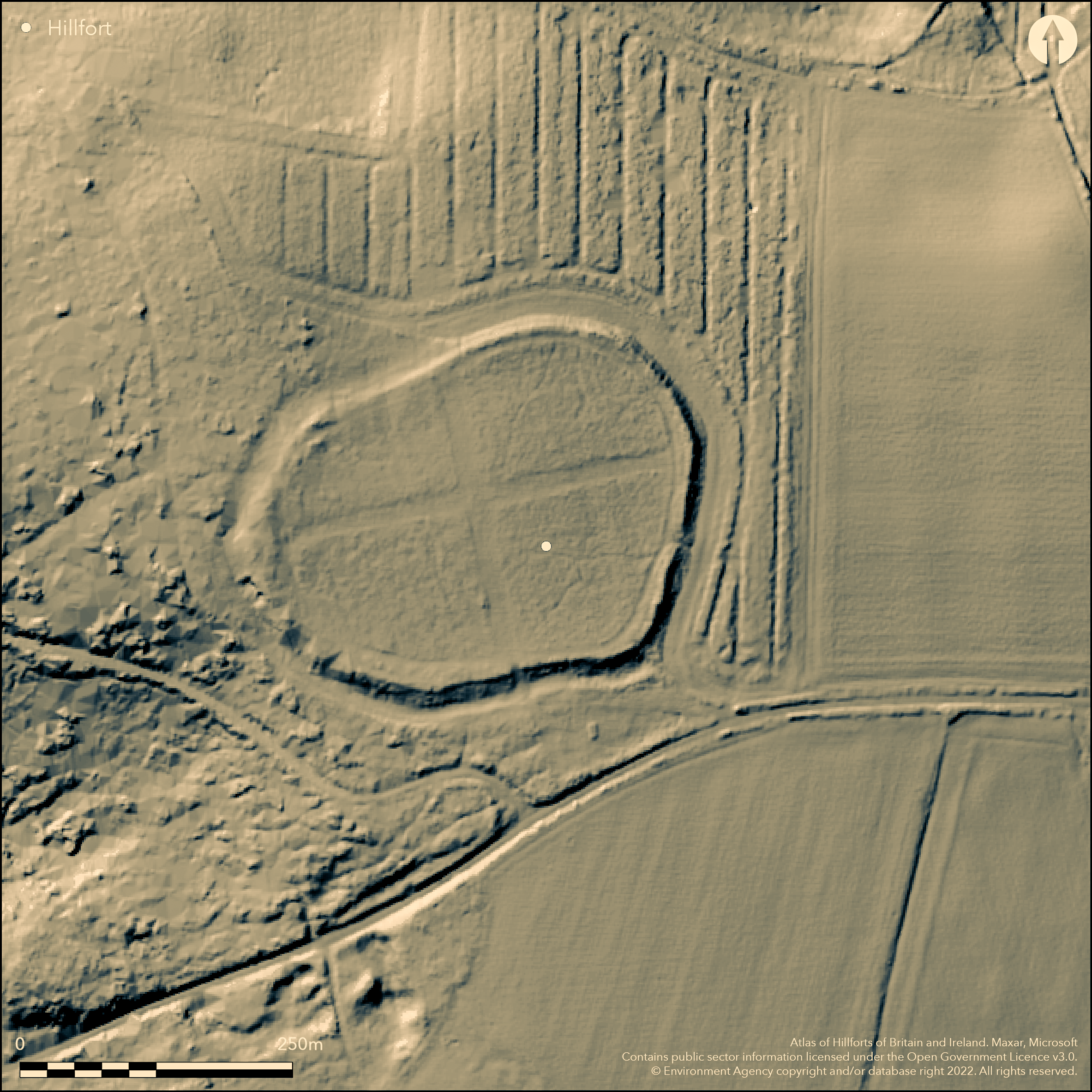
LiDAR 1m DTM Hillshade
Satellite Imagery
LiDAR 1m DTM Hillshade
Satellite Imagery
Scroll left/right to view further images.
HER: Oxfordshire 7101 (MOX198)
NMR: SU 29 SE 17 (225965)
SM: 1004857
NGR: SU 2611 9466
X: 426150 Y: 194650 (OSGB36)
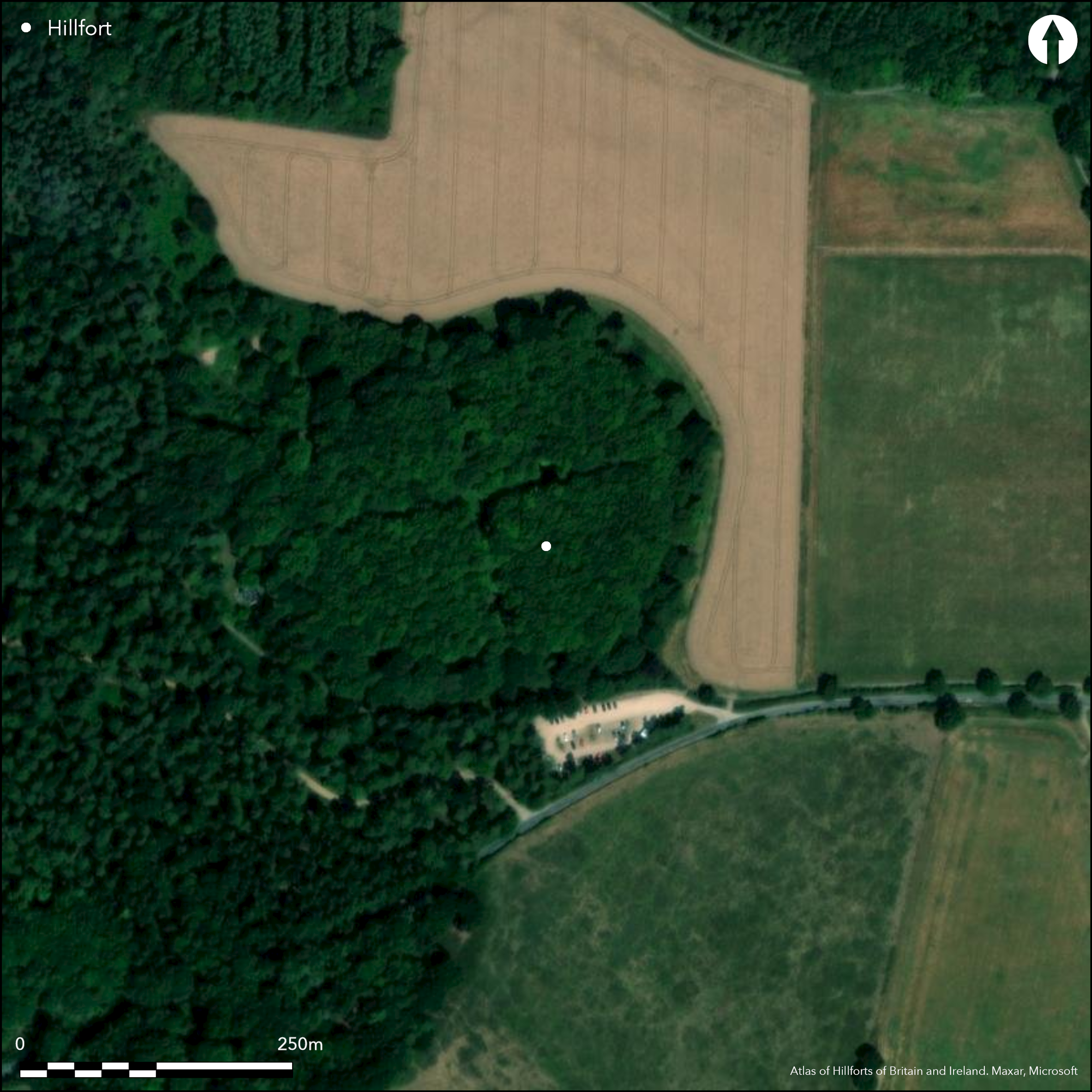
North of Great Coxwell in Badbury Wood (National Trust), a roughly circular contour fort on a slight hill enclosing 3.6ha. Mentioned by various antiquarians, on 1st Ed. OS map. Univallate for entire circuit with possible counterscarp bank to S, rampart up to 0.5m high in places, ditch only survives on S side, rampart much mutilated to W, no more information from LiDAR survey. Wooded over entire site but with two c. 20m wide pathways running N-S and E-W. Entrance at SE, simple gap and geophysics shows a causeway over ditch. Geophysics along the internal pathways shows roundhouses and pits in the interior. Geophysics shows annex ditch running from NE corner, not fully surveyed. Over 100 sherds of late Bronze Age, early and middle Iron Age pottery found by surface collection. Romano-British pottery suggests possible re-use.
Citizen Science: ✓
Reliability of Data: Confirmed
Reliability of Interpretation: Confirmed
X: -180721 Y: 6737085 (EPSG: 3857)
Longitude: -1.6234423326244727 Latitude: 51.6499927608388 (EPSG:4326)
Country: England
Current County or Unitary Authority: Oxfordshire
Historic County: Berkshire
Current Parish/Community/Council/Townland: Great Coxwell
None
| Extant | ✓ |
| Cropmark | ✗ |
| Likely Destroyed | ✗ |
Inner rampart is upstanding earthwork for most of the circuit, within National Trust woodland, some damage due to trees and tracks, possible counterscarp bank is much eroded but still visible in places
| Woodland | ✓ |
| Commercial Forestry Plantation | ✗ |
| Parkland | ✗ |
| Pasture (Grazing) | ✗ |
| Arable | ✗ |
| Scrub/Bracken | ✗ |
| Bare Outcrop | ✗ |
| Heather/Moorland | ✗ |
| Heath | ✗ |
| Built-up | ✗ |
| Coastal Grassland | ✗ |
| Other | ✗ |
Contour fort on flat-topped hill
| Contour Fort | ✓ |
| Partial Contour Fort | ✗ |
| Promontory Fort | ✗ |
| Hillslope Fort | ✗ |
| Level Terrain Fort | ✗ |
| Marsh Fort | ✗ |
| Multiple Enclosure Fort | ✗ |
Contour fort on flat-topped hill
| Hilltop | ✓ |
| Coastal Promontory | ✗ |
| Inland Promontory | ✗ |
| Valley Bottom | ✗ |
| Knoll/Hillock/Outcrop | ✗ |
| Ridge | ✗ |
| Cliff/Plateau-edge/Scarp | ✗ |
| Hillslope | ✗ |
| Lowland | ✗ |
| Spur | ✗ |
Dominant Topographic Feature: Hill with good views
| North | ✗ |
| Northeast | ✗ |
| East | ✗ |
| Southeast | ✗ |
| South | ✗ |
| Southwest | ✗ |
| West | ✗ |
| Northwest | ✗ |
| Level | ✓ |
Altitude: 162.0m
N/A
Possible LBA/EIA sherds, EIA sherds, Romano-British sherds, all from surface collection
Reliability: C - Low
| Pre 1200BC | ✗ |
| 1200BC - 800BC | ✗ |
| 800BC - 400BC | ✓ |
| 400BC - AD50 | ✓ |
| AD50 - AD400 | ✗ |
| AD400 - AD 800 | ✗ |
| Post AD800 | ✗ |
| Unknown | ✗ |
| Pre Hillfort: | None |
| Post Hillfort: | None |
| Artefactual: | Pottery from surface collection |
In Aubrey's Monumenta Britannica (1665-1693). Mentioned by Gough (1790, Biblio Topo Brit 4), on 1st Ed. OS map. Surface finds only, pottery (Hingley 1983). LiDAR and geophysics, 2016 (National Trust and MOLA).
| Other (1983): | Surface survey |
| Other (2003): | Visited by Hillfort Study Group |
| Geophysical Survey (2016): | None |
| LiDAR Survey (2016): | None |
| 1st Identified Written Reference (None): | None |
| 1st Identified Map Depiction (None): | 1st Ed. OS |
No excavation, geophysics shows roundhouses and pits. Surface finds only, pottery (Hingley 1983)
None
| None | ✓ |
| Spring | ✗ |
| Stream | ✗ |
| Pool | ✗ |
| Flush | ✗ |
| Well | ✗ |
| Other | ✗ |
None
| No Known Features | ✓ |
| Round Stone Structures | ✗ |
| Rectangular Stone Structures | ✗ |
| Curvilinear Platforms | ✗ |
| Other Roundhouse Evidence | ✗ |
| Pits | ✗ |
| Quarry Hollows | ✗ |
| Other | ✗ |
None
| No Known Excavation | ✓ |
| Pits | ✗ |
| Postholes | ✗ |
| Roundhouses | ✗ |
| Rectangular Structures | ✗ |
| Roads/Tracks | ✗ |
| Quarry Hollows | ✗ |
| Other | ✗ |
| Nothing Found | ✗ |
None
| No Known Geophysics | ✗ |
| Pits | ✓ |
| Roundhouses | ✓ |
| Rectangular Structures | ✗ |
| Roads/Tracks | ✗ |
| Quarry Hollows | ✗ |
| Other | ✗ |
| Nothing Found | ✗ |
Surface finds only, pottery (Hingley 1983)
| No Known Finds | ✗ |
| Pottery | ✓ |
| Metal | ✗ |
| Metalworking | ✗ |
| Human Bones | ✗ |
| Animal Bones | ✗ |
| Lithics | ✗ |
| Environmental | ✗ |
| Other | ✗ |
None
| APs Not Checked | ✓ |
| None | ✗ |
| Roundhouses | ✗ |
| Rectangular Structures | ✗ |
| Pits | ✗ |
| Postholes | ✗ |
| Roads/Tracks | ✗ |
| Other | ✗ |
Possible entrance represented by 12m gap in rampart on the E side, supported by geophysics showing causeway.
| None: | Unknown due to woodland cover |
| 2: | None |
Guard Chambers: ✗
Chevaux de Frise: ✗
| 1. Simple Gap (South east): | Possible entrance represented by 12m gap in rampart on the E side. |
A low bank averages 10.0m wide overall, 0.5m high internally and 1.0m high externally. An outer ditch, 0.7m deep and 10.0m wide, survives only on the S side.On the E side, 20.0m from the rampart and parallel to it, is a faint rise in the pasture field which may represent a counterscarp bank
| Area 1: | 3.6ha. |
| Total: | 3.6ha. |
Total Footprint Area: Noneha.
Univallate with single ditch for whole circuit, possible second rampart or counterscarp bank to S
| ✗ | None |
| ✓ | None |
| NE Quadrant: | 1 |
| SE Quadrant: | 1 |
| SW Quadrant: | 1 |
| NW Quadrant: | 1 |
| Total: | 1 |
| Partial Univallate | ✗ |
| Univallate | ✓ |
| Partial Bivallate | ✗ |
| Bivallate | ✗ |
| Partial Multivallate | ✗ |
| Multivallate | ✗ |
| Unknown | ✗ |
| Partial Univallate | ✗ |
| Univallate | ✗ |
| Partial Bivallate | ✗ |
| Bivallate | ✗ |
| Partial Multivallate | ✗ |
| Multivallate | ✗ |
Earthen bank
| None | ✗ |
| Earthen Bank | ✓ |
| Stone Wall | ✗ |
| Rubble | ✗ |
| Wall-walk | ✗ |
| Evidence of Timber | ✗ |
| Vitrification | ✗ |
| Other Burning | ✗ |
| Palisade | ✗ |
| Counter Scarp Bank | ✓ |
| Berm | ✗ |
| Unfinished | ✗ |
| Other | ✗ |
None
| None | ✗ |
| Earthen Bank | ✗ |
| Stone Wall | ✗ |
| Murus Duplex | ✗ |
| Timber-framed | ✗ |
| Timber-laced | ✗ |
| Vitrification | ✗ |
| Other Burning | ✗ |
| Palisade | ✗ |
| Counter Scarp Bank | ✗ |
| Berm | ✗ |
| Unfinished | ✗ |
| No Known Excavation | ✓ |
| Other | ✗ |
| ✗ | None |
| ✓ | Single ditch, best on S side, 0.7m deep and 10m wide. |
Number of Ditches: 1
| ✓ | Shown by geophysics, ditch running N form NE corner. |
Cotton, M. A. 1962. Berkshire Hill Forts. Berkshire Archaeol J, 60: 30-52
Hingley, R. 1983. Great Coxwell: Badbury. S Midlands Archaeol, 13, 128-9
National Trust and MOLA. 2016. LiDAR and geophysical survey, Badbury Camp. Unpublished report.
Atlas of Hillforts:
Wikidata:
This work is licensed under CC BY-SA 4.0![]()
![]()
![]() and should be cited as:
and should be cited as:
Lock, Gary and Ralston, Ian. 2024. Atlas of Hillforts of Britain and Ireland. Available at: https://hillforts.arch.ox.ac.uk
Document Version 1.1