LiDAR 1m DTM Hillshade
Satellite Imagery
LiDAR 1m DTM Hillshade
Satellite Imagery
Scroll left/right to view further images.
HER: Oxfordshire 7304 (MOX227)
NMR: SU 28 NE 6 (225401)
SM: 1008412
NGR: SU 2995 8633
X: 429945 Y: 186325 (OSGB36)
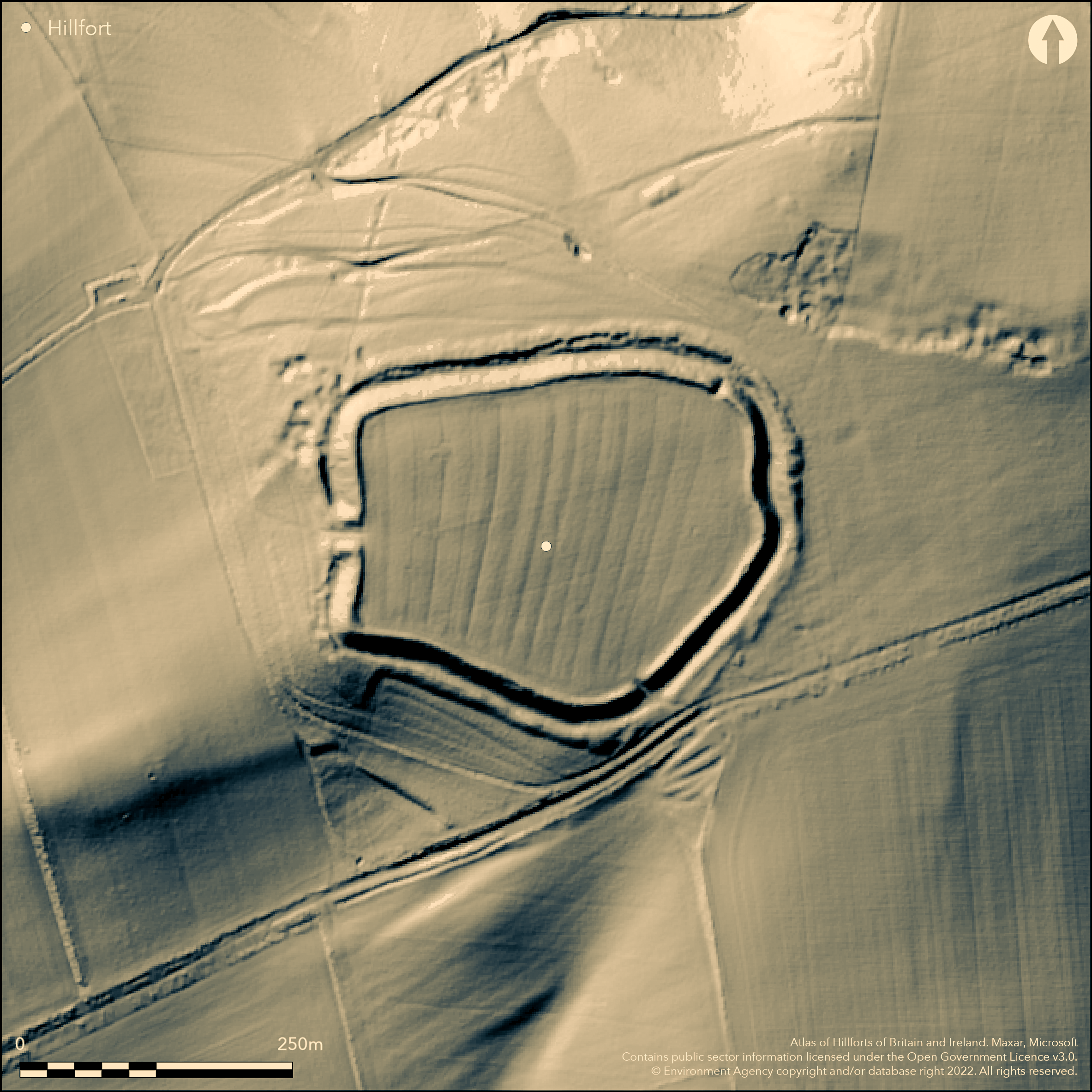
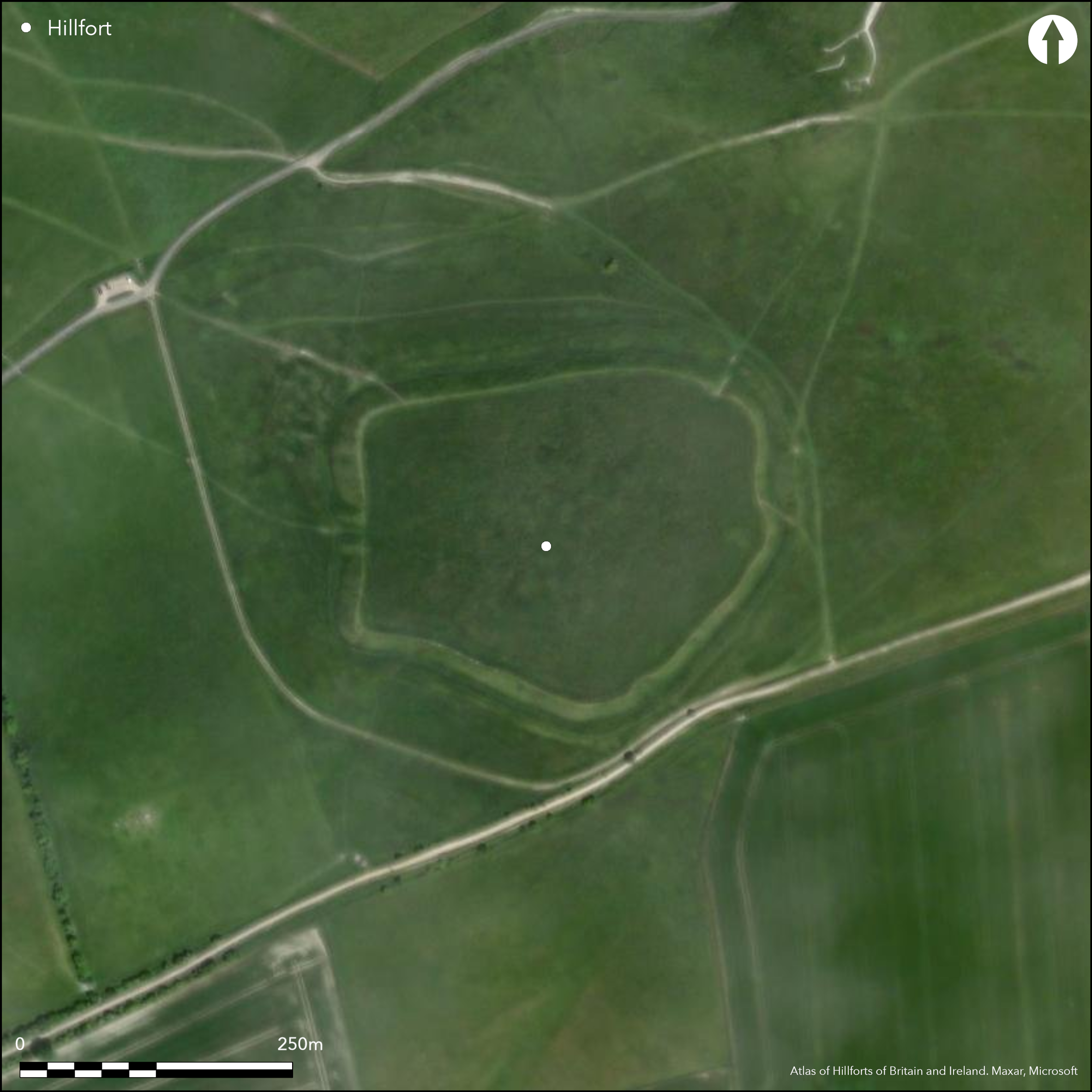
Near the village of Uffington, on White Horse Hill, a dominant position overlooking the Vale of the White Horse to the N and the Berkshire Downs to the S. In Aubrey's Monumenta Britannica (1665-93). Associated with the complex of monuments on the hill, especially the Uffington White Horse and Dragon Hill. A well preserved (National Trust) D-shaped enclosure of 3.2ha, univallate with ditch and counterscarp bank for entire circuit, Blocked entrance to the E which was originally a passageway with guard chambers, original entrance to W which is out-turned and links with enlarged counterscarp bank, two breaks through the rampart at NE and SE which are probably Romano-British. Geophysics and excavation (Miles et al 2003) have revealed internal features and dated the ramparts to two phases: box rampart c.8th/7th century BC, dump rampart c.4th century BC. Romano-British re-use of the enclosure, 2nd-4th centuries AD.
Citizen Science: ✓
Reliability of Data: Confirmed
Reliability of Interpretation: Confirmed
X: -174694 Y: 6723633 (EPSG: 3857)
Longitude: -1.5693000610685042 Latitude: 51.574952162945884 (EPSG:4326)
Country: England
Current County or Unitary Authority: Oxfordshire
Historic County: Berkshire
Current Parish/Community/Council/Townland: Uffington
None
| Extant | ✓ |
| Cropmark | ✗ |
| Likely Destroyed | ✗ |
Preservation is good for rampart, ditch, counterscarp and western entrance. Interior has been ploughed in the past, now National Trust, sheep grazing. SSSI.
| Woodland | ✗ |
| Commercial Forestry Plantation | ✗ |
| Parkland | ✗ |
| Pasture (Grazing) | ✓ |
| Arable | ✗ |
| Scrub/Bracken | ✗ |
| Bare Outcrop | ✗ |
| Heather/Moorland | ✗ |
| Heath | ✗ |
| Built-up | ✗ |
| Coastal Grassland | ✗ |
| Other | ✗ |
A contour fort on a prominent hill on the chalk escarpment overlooking the Vale of the White Horse
| Contour Fort | ✓ |
| Partial Contour Fort | ✗ |
| Promontory Fort | ✗ |
| Hillslope Fort | ✗ |
| Level Terrain Fort | ✗ |
| Marsh Fort | ✗ |
| Multiple Enclosure Fort | ✗ |
A contour fort on a prominent hill on the chalk escarpment overlooking the Vale of the White Horse
| Hilltop | ✗ |
| Coastal Promontory | ✗ |
| Inland Promontory | ✗ |
| Valley Bottom | ✗ |
| Knoll/Hillock/Outcrop | ✗ |
| Ridge | ✗ |
| Cliff/Plateau-edge/Scarp | ✓ |
| Hillslope | ✗ |
| Lowland | ✗ |
| Spur | ✗ |
Dominant Topographic Feature: On the chalk escarpment, good views in all directions.
| North | ✗ |
| Northeast | ✗ |
| East | ✗ |
| Southeast | ✗ |
| South | ✗ |
| Southwest | ✗ |
| West | ✗ |
| Northwest | ✗ |
| Level | ✓ |
Altitude: 260.0m
N/A
1st phase c. 8th/7th century BC (box rampart), 2nd phase c. 4th century BC (dump rampart). Romano-British re-use and modification
Reliability: A - High
| Pre 1200BC | ✗ |
| 1200BC - 800BC | ✗ |
| 800BC - 400BC | ✓ |
| 400BC - AD50 | ✗ |
| AD50 - AD400 | ✓ |
| AD400 - AD 800 | ✗ |
| Post AD800 | ✗ |
| Unknown | ✗ |
| Pre Hillfort: | None |
| Post Hillfort: | None |
| Artefactual: | Iron Age and Romano-British pottery typology |
In Aubrey's Monumenta Britannica (1665-93). Excavations and geophysics 1989-1995, interior, ramparts and surrounding monuments including a RB enclosure, the White Horse, the long barrow and nearby Tower Hill LBA settlement (Miles et. al. 2003).
| Geophysical Survey (1989): | None |
| Geophysical Survey (1990): | None |
| Other (2003): | Visited by Hillfort Study Group |
| 1st Identified Written Reference (None): | Aubrey's Monumenta Britannica |
| Excavation (None): | Miles et al 2003 |
No internal features from surface evidence, pits, postholes, rectangular structures fro geophysics and excavations. A good range of material culture and environmental evidence from excavations.
No water inside, springs at the foot of the escarpment within 1km
| None | ✓ |
| Spring | ✗ |
| Stream | ✗ |
| Pool | ✗ |
| Flush | ✗ |
| Well | ✗ |
| Other | ✗ |
None
| No Known Features | ✓ |
| Round Stone Structures | ✗ |
| Rectangular Stone Structures | ✗ |
| Curvilinear Platforms | ✗ |
| Other Roundhouse Evidence | ✗ |
| Pits | ✗ |
| Quarry Hollows | ✗ |
| Other | ✗ |
Pits and possible 4-poster
| No Known Excavation | ✗ |
| Pits | ✓ |
| Postholes | ✓ |
| Roundhouses | ✗ |
| Rectangular Structures | ✓ |
| Roads/Tracks | ✗ |
| Quarry Hollows | ✗ |
| Other | ✗ |
| Nothing Found | ✗ |
Magnetometry shows pits and other possible features
| No Known Geophysics | ✗ |
| Pits | ✓ |
| Roundhouses | ✗ |
| Rectangular Structures | ✗ |
| Roads/Tracks | ✗ |
| Quarry Hollows | ✗ |
| Other | ✗ |
| Nothing Found | ✗ |
A good range of material culture and environmental evidence from modern excavations
| No Known Finds | ✗ |
| Pottery | ✓ |
| Metal | ✓ |
| Metalworking | ✗ |
| Human Bones | ✓ |
| Animal Bones | ✓ |
| Lithics | ✓ |
| Environmental | ✓ |
| Other | ✗ |
None
| APs Not Checked | ✗ |
| None | ✓ |
| Roundhouses | ✗ |
| Rectangular Structures | ✗ |
| Pits | ✗ |
| Postholes | ✗ |
| Roads/Tracks | ✗ |
| Other | ✗ |
Original entrance to the W, out-turned corridor linking to counterscarp bank. Blocked entrance to E shown by change in the line of the rampart and by excavation, originally a passageway with guard chambers. Two breaks through the rampart (NE and SE) not original, may be Roman.
| 4: | None |
| 2: | None |
Guard Chambers: ✓
Chevaux de Frise: ✗
| 1. Passage-way/Corridor (West): | Original entrance to the W, out-turned corridor linking to counterscarp bank |
| 2. Blocked (East): | Blocked entrance to E shown by change in the line of the rampart and by excavation. |
| 2. Passage-way/Corridor (East): | None |
Univallate with ditch and counterscarp bank for whole circuit. First phase - box rampart, small outer ditch. Second phase - dump rampart, inner low revetting wall of chalk blocks, large V-shaped ditch
| Area 1: | 3.2ha. |
| Total: | 3.2ha. |
Total Footprint Area: Noneha.
Univallate with ditch and counterscarp bank for whole circuit.
| ✗ | None |
| ✓ | None |
| NE Quadrant: | 1 |
| SE Quadrant: | 1 |
| SW Quadrant: | 1 |
| NW Quadrant: | 1 |
| Total: | 1 |
| Partial Univallate | ✗ |
| Univallate | ✓ |
| Partial Bivallate | ✗ |
| Bivallate | ✗ |
| Partial Multivallate | ✗ |
| Multivallate | ✗ |
| Unknown | ✗ |
| Partial Univallate | ✗ |
| Univallate | ✗ |
| Partial Bivallate | ✗ |
| Bivallate | ✗ |
| Partial Multivallate | ✗ |
| Multivallate | ✗ |
Earthen bank with counterscarp
| None | ✗ |
| Earthen Bank | ✓ |
| Stone Wall | ✗ |
| Rubble | ✗ |
| Wall-walk | ✗ |
| Evidence of Timber | ✗ |
| Vitrification | ✗ |
| Other Burning | ✗ |
| Palisade | ✗ |
| Counter Scarp Bank | ✓ |
| Berm | ✗ |
| Unfinished | ✗ |
| Other | ✗ |
First phase - box rampart, small outer ditch. Second phase - dump rampart, inner low revetting wall of chalk blocks, large V-shaped ditch
| None | ✗ |
| Earthen Bank | ✓ |
| Stone Wall | ✓ |
| Murus Duplex | ✗ |
| Timber-framed | ✓ |
| Timber-laced | ✗ |
| Vitrification | ✗ |
| Other Burning | ✗ |
| Palisade | ✗ |
| Counter Scarp Bank | ✓ |
| Berm | ✓ |
| Unfinished | ✗ |
| No Known Excavation | ✗ |
| Other | ✗ |
| ✗ | None |
| ✓ | One ditch for each of the two phases of rampart |
Number of Ditches: 1
| ✗ | None |
Miles, D., Palmer, S., Lock, G., Gosden, C. and Cromarty, A-M. 2003. Uffington White Horse and its landscape. Investigations at White Horse Hill Uffington, 1989-95 and Tower Hill Ashbury, 1993-4. Oxford: Oxford Archaeology. Thames Valley Landscapes Monograph 18.
Noon, S. 1990. UFFINGTON CASTLE, OXFORDSHIRE: REPORT ON GEOPHYSICAL SURVEY, 1989. AM LAB REPORT 94/90
Atlas of Hillforts:
Wikidata:
This work is licensed under CC BY-SA 4.0![]()
![]()
![]() and should be cited as:
and should be cited as:
Lock, Gary and Ralston, Ian. 2024. Atlas of Hillforts of Britain and Ireland. Available at: https://hillforts.arch.ox.ac.uk
Document Version 1.1