LiDAR 1m DTM Hillshade
Satellite Imagery
LiDAR 1m DTM Hillshade
Satellite Imagery
Scroll left/right to view further images.
HER: Oxfordshire 2320 (MOX303)
NMR: SP 43 W 11 (337097)
SM: 1015167
NGR: SP 4378 3055
X: 443779 Y: 230642 (OSGB36)
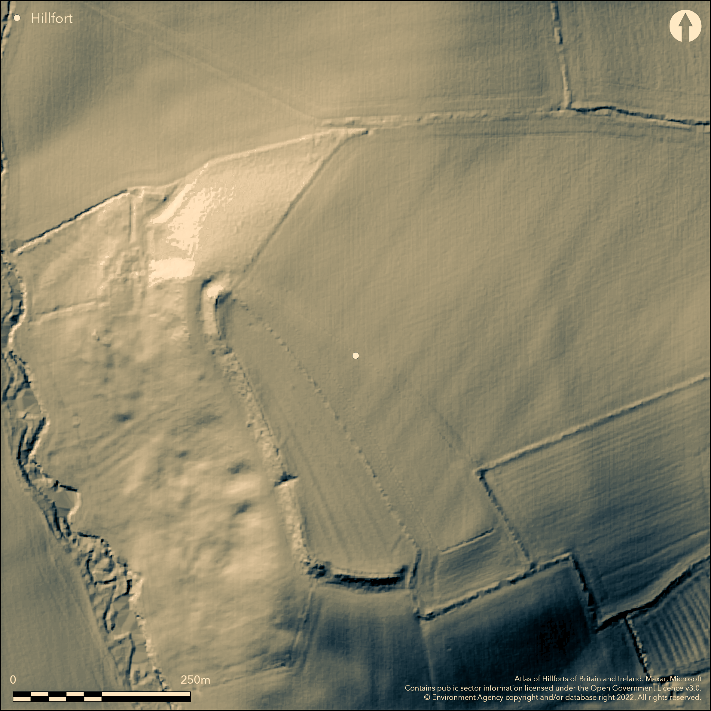
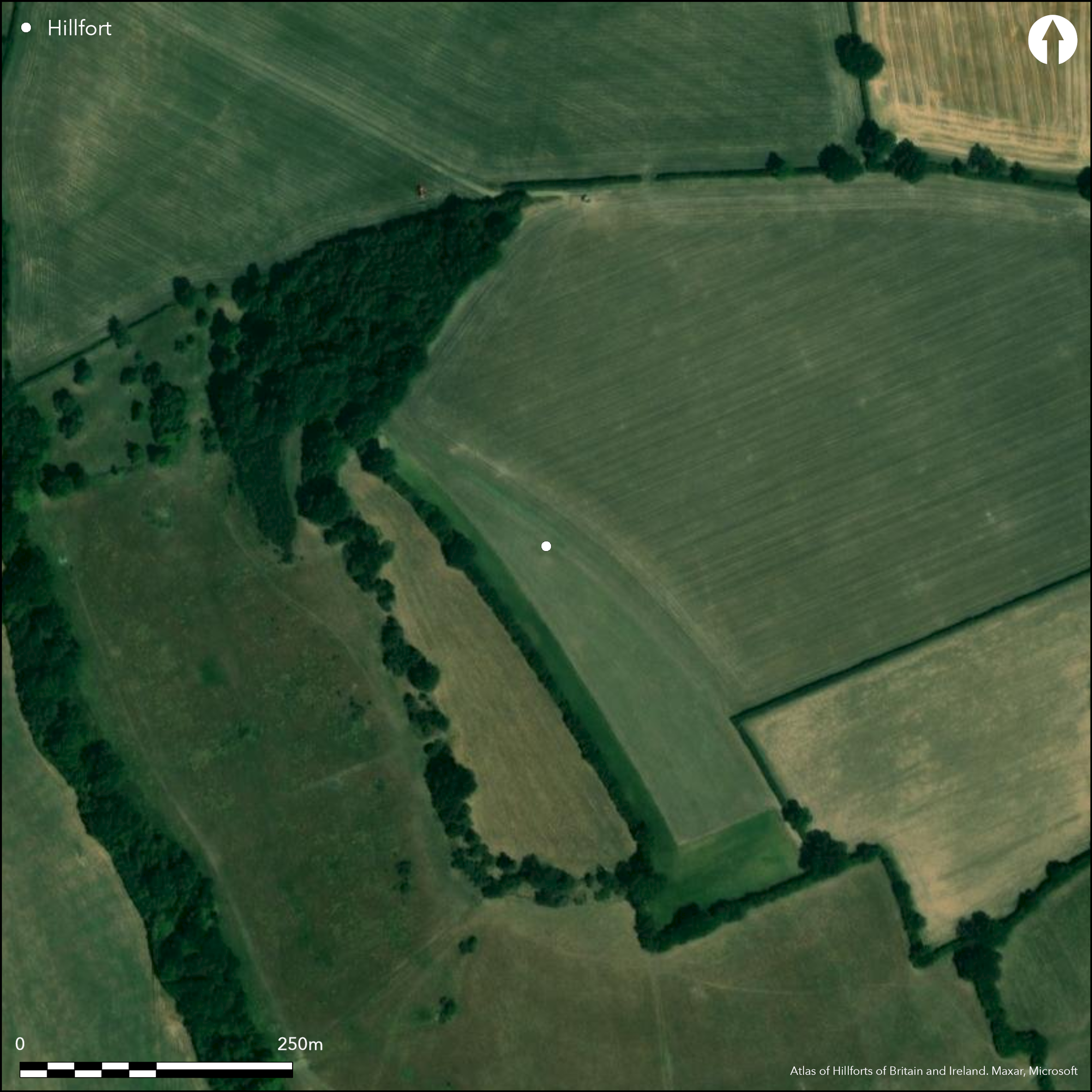
NE of Nether Worton, situated on a prominent hilltop with good views in all directions. Mentioned in the Domesday Book (1086) and on the 1st Ed. OS map. A kidney shaped univallate enclosure of 2.4ha, the rampart contains stone, and survives up to c.4m high and c.10m wide at the NW, ploughed away along the E side bit still visible as c.1m high rise, ditch is c.0.6m deep and c.12m wide on W side and shows as a crop mark along the E. A single entrance at the SE. The interior and E half of the fort have been ploughed, the W rampart is tree and scrub covered. No interventions but surface finds of Iron Age pottery, also early Romano-British and medieval.
Citizen Science: ✓
Reliability of Data: Confirmed
Reliability of Interpretation: Confirmed
X: -151852 Y: 6795153 (EPSG: 3857)
Longitude: -1.364108854773655 Latitude: 51.97248982681769 (EPSG:4326)
Country: England
Current County or Unitary Authority: Oxfordshire
Historic County: Oxfordshire
Current Parish/Community/Council/Townland: Deddington
On Heritage at Risk Register (2015).
| Extant | ✓ |
| Cropmark | ✗ |
| Likely Destroyed | ✗ |
Upstanding mainly around the W half, bank covered by trees and shrubs. Split be fence line through the middle with pasture to the W and arable to the E resulting in the E rampart being much denuded.
| Woodland | ✗ |
| Commercial Forestry Plantation | ✗ |
| Parkland | ✗ |
| Pasture (Grazing) | ✓ |
| Arable | ✓ |
| Scrub/Bracken | ✓ |
| Bare Outcrop | ✗ |
| Heather/Moorland | ✗ |
| Heath | ✗ |
| Built-up | ✗ |
| Coastal Grassland | ✗ |
| Other | ✗ |
A pear-shaped partial contour fort which uses the natural slopes on the W and S sides, on the top of a prominent hill with good views all around.
| Contour Fort | ✓ |
| Partial Contour Fort | ✗ |
| Promontory Fort | ✗ |
| Hillslope Fort | ✗ |
| Level Terrain Fort | ✗ |
| Marsh Fort | ✗ |
| Multiple Enclosure Fort | ✗ |
| Hilltop | ✓ |
| Coastal Promontory | ✗ |
| Inland Promontory | ✗ |
| Valley Bottom | ✗ |
| Knoll/Hillock/Outcrop | ✗ |
| Ridge | ✗ |
| Cliff/Plateau-edge/Scarp | ✗ |
| Hillslope | ✗ |
| Lowland | ✗ |
| Spur | ✗ |
Dominant Topographic Feature: On prominent hill with good views all around
| North | ✗ |
| Northeast | ✗ |
| East | ✗ |
| Southeast | ✗ |
| South | ✗ |
| Southwest | ✗ |
| West | ✗ |
| Northwest | ✗ |
| Level | ✓ |
Altitude: 122.0m
N/A
Iron Age pottery from the interior/rampart surface, also early Romano-British and medieval.
Reliability: C - Low
| Pre 1200BC | ✗ |
| 1200BC - 800BC | ✗ |
| 800BC - 400BC | ✓ |
| 400BC - AD50 | ✓ |
| AD50 - AD400 | ✗ |
| AD400 - AD 800 | ✗ |
| Post AD800 | ✗ |
| Unknown | ✗ |
| Pre Hillfort: | None |
| Post Hillfort: | None |
| Artefactual: | Iron Age pottery from the interior/rampart surface |
Mentioned in the Domesday Book (1086) and on the 1st Ed. OS map. Surface finds of pottery.
| 1st Identified Written Reference (1086): | Domesday Book |
| 1st Identified Map Depiction (None): | 1st Ed. OS |
| Other (None): | Surface finds |
No surface evidence or investigations, interior has been ploughed.
None
| None | ✓ |
| Spring | ✗ |
| Stream | ✗ |
| Pool | ✗ |
| Flush | ✗ |
| Well | ✗ |
| Other | ✗ |
None
| No Known Features | ✓ |
| Round Stone Structures | ✗ |
| Rectangular Stone Structures | ✗ |
| Curvilinear Platforms | ✗ |
| Other Roundhouse Evidence | ✗ |
| Pits | ✗ |
| Quarry Hollows | ✗ |
| Other | ✗ |
None
| No Known Excavation | ✓ |
| Pits | ✗ |
| Postholes | ✗ |
| Roundhouses | ✗ |
| Rectangular Structures | ✗ |
| Roads/Tracks | ✗ |
| Quarry Hollows | ✗ |
| Other | ✗ |
| Nothing Found | ✗ |
None
| No Known Geophysics | ✓ |
| Pits | ✗ |
| Roundhouses | ✗ |
| Rectangular Structures | ✗ |
| Roads/Tracks | ✗ |
| Quarry Hollows | ✗ |
| Other | ✗ |
| Nothing Found | ✗ |
Surface finds of pottery, Iron Age
| No Known Finds | ✗ |
| Pottery | ✓ |
| Metal | ✗ |
| Metalworking | ✗ |
| Human Bones | ✗ |
| Animal Bones | ✗ |
| Lithics | ✗ |
| Environmental | ✗ |
| Other | ✗ |
None
| APs Not Checked | ✓ |
| None | ✗ |
| Roundhouses | ✗ |
| Rectangular Structures | ✗ |
| Pits | ✗ |
| Postholes | ✗ |
| Roads/Tracks | ✗ |
| Other | ✗ |
Original entrance at SE corner (8m gap in rampart), four other gaps not original
| 5: | None |
| 2: | None |
Guard Chambers: ✗
Chevaux de Frise: ✗
| 1. Simple Gap (South east): | Simple gap c8m wide at SE |
A single rampart and ditch around the entire circuit, possible counterscarp bank. Rampart contains stone, and survives up to c.4m high and c.10m wide at the NW, ploughed away along the E side bit still visible as c.1m high rise, ditch is c.0.6m deep and c.12m wide on W side and shows as a crop mark along the E.
| Area 1: | 2.4ha. |
| Total: | 2.4ha. |
Total Footprint Area: Noneha.
A single rampart and ditch around the whole circuit, evidence for a possible counterscarp bank on the W.
| ✗ | None |
| ✓ | None |
| NE Quadrant: | 1 |
| SE Quadrant: | 1 |
| SW Quadrant: | 1 |
| NW Quadrant: | 1 |
| Total: | 1 |
| Partial Univallate | ✗ |
| Univallate | ✓ |
| Partial Bivallate | ✗ |
| Bivallate | ✗ |
| Partial Multivallate | ✗ |
| Multivallate | ✗ |
| Unknown | ✗ |
| Partial Univallate | ✗ |
| Univallate | ✗ |
| Partial Bivallate | ✗ |
| Bivallate | ✗ |
| Partial Multivallate | ✗ |
| Multivallate | ✗ |
Rubble and earthen bank on the W side, possible counterscarp.
| None | ✗ |
| Earthen Bank | ✓ |
| Stone Wall | ✗ |
| Rubble | ✓ |
| Wall-walk | ✗ |
| Evidence of Timber | ✗ |
| Vitrification | ✗ |
| Other Burning | ✗ |
| Palisade | ✗ |
| Counter Scarp Bank | ✓ |
| Berm | ✗ |
| Unfinished | ✗ |
| Other | ✗ |
None
| None | ✓ |
| Earthen Bank | ✗ |
| Stone Wall | ✗ |
| Murus Duplex | ✗ |
| Timber-framed | ✗ |
| Timber-laced | ✗ |
| Vitrification | ✗ |
| Other Burning | ✗ |
| Palisade | ✗ |
| Counter Scarp Bank | ✗ |
| Berm | ✗ |
| Unfinished | ✗ |
| No Known Excavation | ✗ |
| Other | ✗ |
| ✗ | None |
| ✓ | Single ditch all around. |
Number of Ditches: 1
| ✗ | None |
Manning, P. and Leeds, E.T. 1921. An archaeological survey of Oxfordshire. London: Society of Antiquaries.
Page, W. (ed) 1907. The Victoria History of the County of Oxford, Vol II, London, 311.
Sutton, J.E.G. 1966. Iron-Age hill-forts and some other earthworks in Oxfordshire, Oxoniensia, 31, 28-42.
Atlas of Hillforts:
Wikidata:
This work is licensed under CC BY-SA 4.0![]()
![]()
![]() and should be cited as:
and should be cited as:
Lock, Gary and Ralston, Ian. 2024. Atlas of Hillforts of Britain and Ireland. Available at: https://hillforts.arch.ox.ac.uk
Document Version 1.1