LiDAR 1m DTM Hillshade
Satellite Imagery
LiDAR 1m DTM Hillshade
Satellite Imagery
Scroll left/right to view further images.
HER: Oxfordshire 7320 (MOX319)
NMR: SU 28 NE 12 (225417)
SM: 1017820
NGR: SU 2876 8673
X: 428755 Y: 186745 (OSGB36)
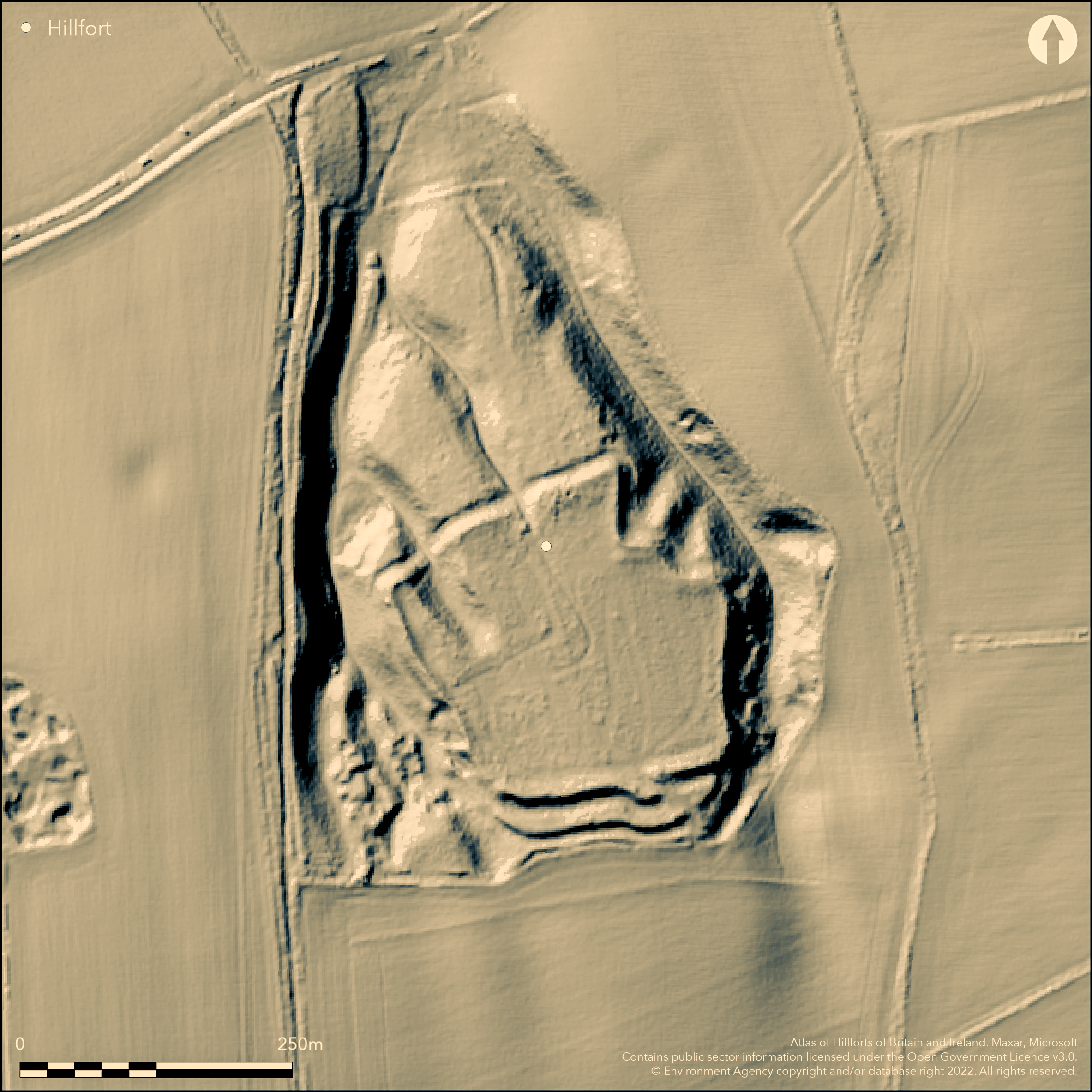
E of Compton Beauchamp, situated on a promontory of the chalk downs overlooking the Vale of the White Horse to the N, not the highest point as it is overlooked, two small valleys run from the site N down the scarp slope. Mentioned in Aubrey's Monumenta Britannica (1665-1693), on the 1st Ed. OS map. A complex site which is difficult to interpret using ramparts, ditches and natural slopes. To the N the main rampart runns along the top edge of the small valleys, built of stone rubble and turf and measures c.10m wide, standing between 0.5m and 1.5m high above the interior. The rampart runs along the E and W sides, and E-W across the relatively level ground to the S where this more open side is further protected by a c.16m wide outer ditch and a second outer bank of similar proportions to the first which connects with the entrance hornwork. One good original entrance in SE corner, possible corridor with outworks/hornwork, possible small N entrance, simple gap directly on to steep slope leading down the scarp face. The whole site is covered with dense woodland and scrub, no interventions but probably middle Iron Age based on the rampart morphology, especially the SE entrance.
Citizen Science: ✗
Reliability of Data: Confirmed
Reliability of Interpretation: Confirmed
X: -176601 Y: 6724321 (EPSG: 3857)
Longitude: -1.5864371938959023 Latitude: 51.57879026275009 (EPSG:4326)
Country: England
Current County or Unitary Authority: Oxfordshire
Historic County: Berkshire
Current Parish/Community/Council/Townland: Compton Beauchamp
None
| Extant | ✓ |
| Cropmark | ✗ |
| Likely Destroyed | ✗ |
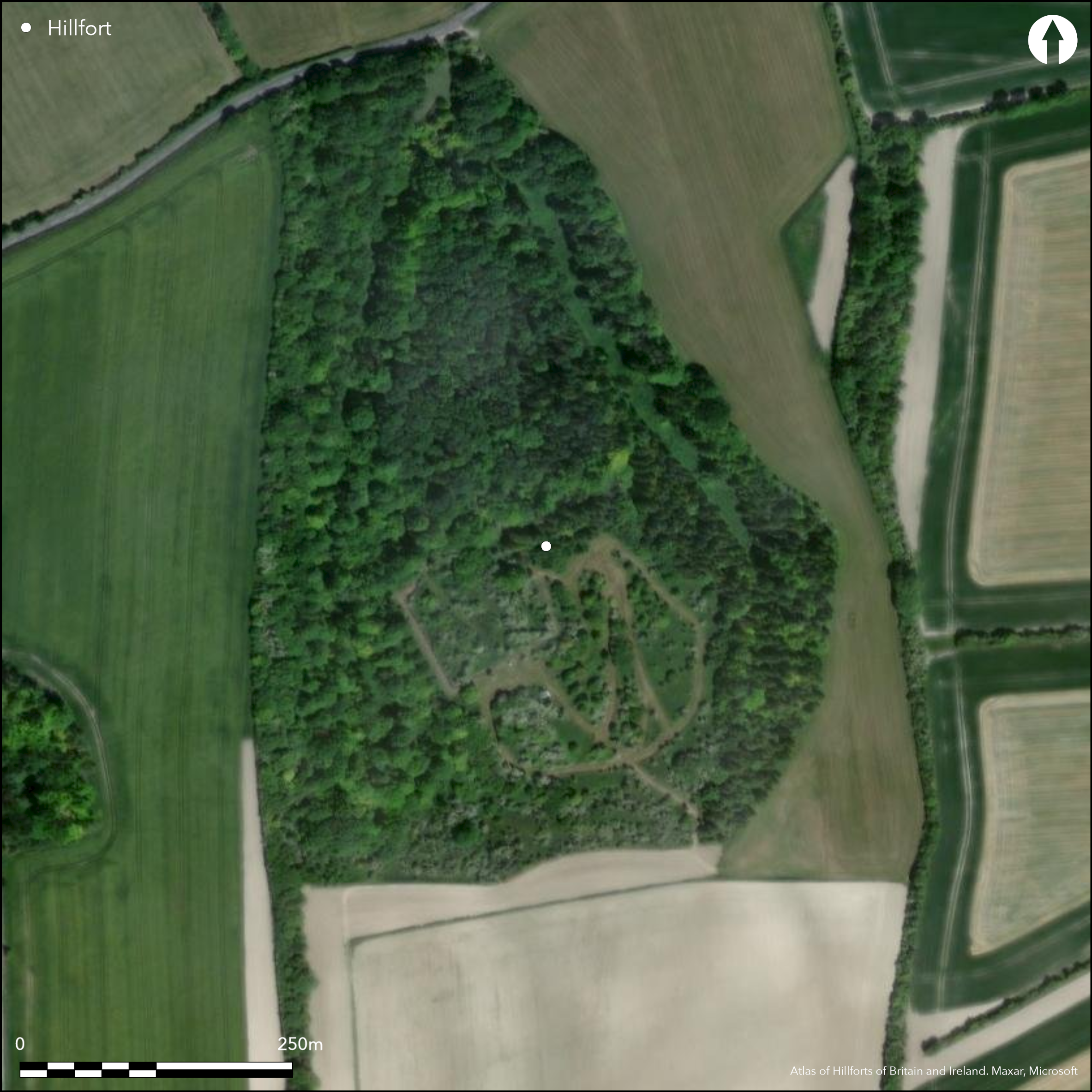
Ramparts upstanding but heavily wooded as is most of interior making it very difficult to interpret
| Woodland | ✓ |
| Commercial Forestry Plantation | ✗ |
| Parkland | ✗ |
| Pasture (Grazing) | ✗ |
| Arable | ✗ |
| Scrub/Bracken | ✓ |
| Bare Outcrop | ✗ |
| Heather/Moorland | ✗ |
| Heath | ✗ |
| Built-up | ✗ |
| Coastal Grassland | ✗ |
| Other | ✗ |
A complex site, situated on a promontory of the chalk escarpment, not the highest point so is overlooked, uses natural slopes of two small steep valleys running from the N, a more gentle approach from the S where themain entrance is
| Contour Fort | ✗ |
| Partial Contour Fort | ✗ |
| Promontory Fort | ✓ |
| Hillslope Fort | ✗ |
| Level Terrain Fort | ✗ |
| Marsh Fort | ✗ |
| Multiple Enclosure Fort | ✗ |
| Hilltop | ✗ |
| Coastal Promontory | ✗ |
| Inland Promontory | ✓ |
| Valley Bottom | ✗ |
| Knoll/Hillock/Outcrop | ✗ |
| Ridge | ✗ |
| Cliff/Plateau-edge/Scarp | ✗ |
| Hillslope | ✗ |
| Lowland | ✗ |
| Spur | ✗ |
Dominant Topographic Feature: On chalk scarp overlooking the Vale of the White Horse to the N
| North | ✓ |
| Northeast | ✗ |
| East | ✗ |
| Southeast | ✗ |
| South | ✗ |
| Southwest | ✗ |
| West | ✗ |
| Northwest | ✗ |
| Level | ✗ |
Altitude: 182.0m
N/A
Probably middle Iron Age based on morphology of the earthworks, especially the SE entrance
Reliability: D - None
| Pre 1200BC | ✗ |
| 1200BC - 800BC | ✗ |
| 800BC - 400BC | ✗ |
| 400BC - AD50 | ✓ |
| AD50 - AD400 | ✗ |
| AD400 - AD 800 | ✗ |
| Post AD800 | ✗ |
| Unknown | ✗ |
| Pre Hillfort: | None |
| Post Hillfort: | None |
| Morphology/Earthwork/Typology: | None |
Mentioned in Aubrey's Monumenta Britannica (1665-1693), on the 1st Ed. OS map. No other investigations.
| Other (2003): | Visited by Hillfort Study Group |
| 1st Identified Written Reference (None): | Aubrey's Monumenta Britannica |
| 1st Identified Map Depiction (None): | 1st Ed. OS |
No evidence for internal features
None
| None | ✓ |
| Spring | ✗ |
| Stream | ✗ |
| Pool | ✗ |
| Flush | ✗ |
| Well | ✗ |
| Other | ✗ |
None
| No Known Features | ✓ |
| Round Stone Structures | ✗ |
| Rectangular Stone Structures | ✗ |
| Curvilinear Platforms | ✗ |
| Other Roundhouse Evidence | ✗ |
| Pits | ✗ |
| Quarry Hollows | ✗ |
| Other | ✗ |
None
| No Known Excavation | ✓ |
| Pits | ✗ |
| Postholes | ✗ |
| Roundhouses | ✗ |
| Rectangular Structures | ✗ |
| Roads/Tracks | ✗ |
| Quarry Hollows | ✗ |
| Other | ✗ |
| Nothing Found | ✗ |
None
| No Known Geophysics | ✓ |
| Pits | ✗ |
| Roundhouses | ✗ |
| Rectangular Structures | ✗ |
| Roads/Tracks | ✗ |
| Quarry Hollows | ✗ |
| Other | ✗ |
| Nothing Found | ✗ |
None
| No Known Finds | ✓ |
| Pottery | ✗ |
| Metal | ✗ |
| Metalworking | ✗ |
| Human Bones | ✗ |
| Animal Bones | ✗ |
| Lithics | ✗ |
| Environmental | ✗ |
| Other | ✗ |
None
| APs Not Checked | ✗ |
| None | ✓ |
| Roundhouses | ✗ |
| Rectangular Structures | ✗ |
| Pits | ✗ |
| Postholes | ✗ |
| Roads/Tracks | ✗ |
| Other | ✗ |
One good original entrance in SE corner, possible corridor with outworks/hornwork. Possible small N entrance, simple gap directly on to steep slope leading down the scarp face.
| None: | Unknown |
| 2: | None |
Guard Chambers: ✗
Chevaux de Frise: ✗
| 1. Hornwork (South east): | None |
| 1. Passage-way/Corridor (South east): | None |
| 2. Simple Gap (North): | None |
A complex design using ramparts, ditches and natural slopes. To the N two enclosed spurs extend from the ridge with the main rampart running along their top edge, built of stone rubble and turf and measures c.10m wide, standing between 0.5m and 1.5m high above the interior. The rampart runs E-W across the relatively level ground to the S where it is interrupted by an original entrance. This more open side is further protected by a c.16m wide outer ditch and a second outer bank of similar proportions to the first which connects with the entrance hornwork.
| Area 1: | 2.4ha. |
| Total: | 2.4ha. |
Total Footprint Area: Noneha.
None
| ✗ | None |
| ✗ | None |
| NE Quadrant: | 1 |
| SE Quadrant: | 2 |
| SW Quadrant: | 1 |
| NW Quadrant: | 1 |
| Total: | 2 |
| Partial Univallate | ✓ |
| Univallate | ✗ |
| Partial Bivallate | ✓ |
| Bivallate | ✗ |
| Partial Multivallate | ✗ |
| Multivallate | ✗ |
| Unknown | ✗ |
| Partial Univallate | ✗ |
| Univallate | ✗ |
| Partial Bivallate | ✗ |
| Bivallate | ✗ |
| Partial Multivallate | ✗ |
| Multivallate | ✗ |
Rubble eroding from the bank in places.
| None | ✗ |
| Earthen Bank | ✗ |
| Stone Wall | ✗ |
| Rubble | ✓ |
| Wall-walk | ✗ |
| Evidence of Timber | ✗ |
| Vitrification | ✗ |
| Other Burning | ✗ |
| Palisade | ✗ |
| Counter Scarp Bank | ✗ |
| Berm | ✗ |
| Unfinished | ✗ |
| Other | ✗ |
None
| None | ✓ |
| Earthen Bank | ✗ |
| Stone Wall | ✗ |
| Murus Duplex | ✗ |
| Timber-framed | ✗ |
| Timber-laced | ✗ |
| Vitrification | ✗ |
| Other Burning | ✗ |
| Palisade | ✗ |
| Counter Scarp Bank | ✗ |
| Berm | ✗ |
| Unfinished | ✗ |
| No Known Excavation | ✗ |
| Other | ✗ |
| ✗ | None |
| ✓ | It is unsure where the ditch runs along the N edge, can be traced to the W and E, best seen at the S where it is c.16m wide. |
Number of Ditches: 1
| ✗ | None |
Ditchfield, P.H. and Page, W. 1906 The Victoria history of Berkshire, Vol. 1., London, 172-3
Cotton, M. A. 1962. Berkshire Hill Forts. Berkshire Archaeol J, 60, 51.
Steane, J. 1982. Hardwell Camp, S Midlands Archaeol, 12, 87-88.
Atlas of Hillforts:
Wikidata:
This work is licensed under CC BY-SA 4.0![]()
![]()
![]() and should be cited as:
and should be cited as:
Lock, Gary and Ralston, Ian. 2024. Atlas of Hillforts of Britain and Ireland. Available at: https://hillforts.arch.ox.ac.uk
Document Version 1.1