
LiDAR 1m DTM Hillshade
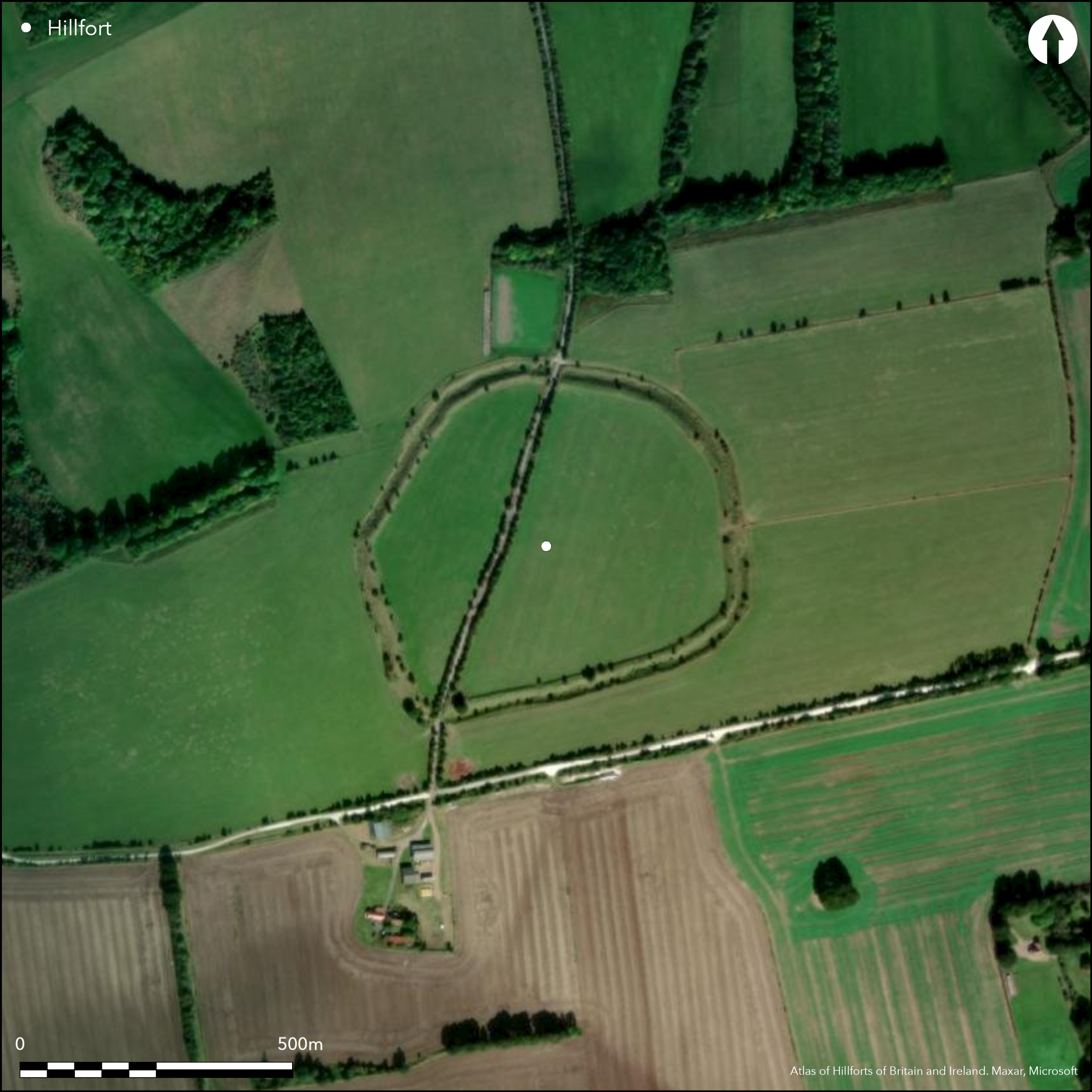
Satellite Imagery
LiDAR 1m DTM Hillshade
Satellite Imagery
Scroll left/right to view further images.
HER: Oxfordshire 7200 (MOX321)
NMR: SU 38 SE 3 (229295)
SM: 1017717
NGR: SU 3850 8448
X: 438500 Y: 184479 (OSGB36)
Overlooking the village of Letcombe Regis on the chalk escarpment with the Ridgeway nearby to the S, a roughly circular contour fort of c.10.7ha. Mentioned in Aubrey's Monumenta Britannica (1665-1693), on Roque's map of 1762. Univallate with ditch for the entire circuit, cut by road creating breaks through the rampart to N and S. Out-turned entrance to the E with hornwork, possible blocked entrance to the SW. Has been deeply ploughed in the interior, ramparts in good condition. Geophysics by English Heritage (Payne et. al. 2006), excavation in the interior, rampart and E entrance in 1996 and 1997 (Lock et. al. 2005). Evidence for pits, roundhouses, environmental, artefacts, dated to c.600 - 200 BC from stratified pottery. A study of the wider area suggests considerable pre- and post-hillfort activity (Levick 2015).
Citizen Science: ✓
Reliability of Data: Confirmed
Reliability of Interpretation: Confirmed
X: -160974 Y: 6720568 (EPSG: 3857)
Longitude: -1.4460572524441297 Latitude: 51.55783663126939 (EPSG:4326)
Country: England
Current County or Unitary Authority: Oxfordshire
Historic County: Berkshire
Current Parish/Community/Council/Townland: Letcombe Regis
None
| Extant | ✓ |
| Cropmark | ✗ |
| Likely Destroyed | ✗ |
Single rampart and outer ditch survive for complete circuit, ditch filled in but still 5m to rampart top in places, counterscarp bank survives in places, best to NW. Interior has been ploughed. Some tree and scrub cover on ramparts and badger damage. SSSI.
| Woodland | ✗ |
| Commercial Forestry Plantation | ✗ |
| Parkland | ✗ |
| Pasture (Grazing) | ✓ |
| Arable | ✗ |
| Scrub/Bracken | ✓ |
| Bare Outcrop | ✗ |
| Heather/Moorland | ✗ |
| Heath | ✗ |
| Built-up | ✗ |
| Coastal Grassland | ✗ |
| Other | ✗ |
Fairly flat position on chalk downs, scarp to the N, the Ridgeway c.20m to the S.
| Contour Fort | ✗ |
| Partial Contour Fort | ✓ |
| Promontory Fort | ✗ |
| Hillslope Fort | ✗ |
| Level Terrain Fort | ✗ |
| Marsh Fort | ✗ |
| Multiple Enclosure Fort | ✗ |
| Hilltop | ✗ |
| Coastal Promontory | ✗ |
| Inland Promontory | ✗ |
| Valley Bottom | ✗ |
| Knoll/Hillock/Outcrop | ✗ |
| Ridge | ✗ |
| Cliff/Plateau-edge/Scarp | ✓ |
| Hillslope | ✗ |
| Lowland | ✗ |
| Spur | ✗ |
Dominant Topographic Feature: On chalk scarp overlooking the Vale of the White Horse
| North | ✗ |
| Northeast | ✗ |
| East | ✗ |
| Southeast | ✗ |
| South | ✗ |
| Southwest | ✗ |
| West | ✗ |
| Northwest | ✗ |
| Level | ✓ |
Altitude: 212.0m
N/A
Excavation suggests 600BC - 200BC.
Reliability: A - High
| Pre 1200BC | ✗ |
| 1200BC - 800BC | ✗ |
| 800BC - 400BC | ✓ |
| 400BC - AD50 | ✓ |
| AD50 - AD400 | ✗ |
| AD400 - AD 800 | ✗ |
| Post AD800 | ✗ |
| Unknown | ✗ |
| Pre Hillfort: | None |
| Post Hillfort: | None |
| Artefactual: | Pottery typology, good excavated stratigraphical contexts |
Mentioned in Aubrey's Monumenta Britannica (1665-1693), on Roque's map of 1762. Geophysical survey by English Heritage of whole interior, excavation by Oxford University of interior, E entrance and rampart.
| 1st Identified Map Depiction (1762): | Roque |
| Other (2003): | Visited by Hillfort Study Group |
| Geophysical Survey (None): | see Payne et. al. 2006. |
| 1st Identified Written Reference (None): | Aubrey's Monumenta Britannica |
| Excavation (None): | see Lock et. al. 2005. |
No surface evidence, geophysics shows pits and roundhouses confirmed by excavation.
None but springs at the foot of the chalk scarp to the N.
| None | ✓ |
| Spring | ✗ |
| Stream | ✗ |
| Pool | ✗ |
| Flush | ✗ |
| Well | ✗ |
| Other | ✗ |
Heavily ploughed.
| No Known Features | ✓ |
| Round Stone Structures | ✗ |
| Rectangular Stone Structures | ✗ |
| Curvilinear Platforms | ✗ |
| Other Roundhouse Evidence | ✗ |
| Pits | ✗ |
| Quarry Hollows | ✗ |
| Other | ✗ |
Good range of structural and artefactual evidence.
| No Known Excavation | ✗ |
| Pits | ✓ |
| Postholes | ✓ |
| Roundhouses | ✓ |
| Rectangular Structures | ✗ |
| Roads/Tracks | ✗ |
| Quarry Hollows | ✗ |
| Other | ✓ |
| Nothing Found | ✗ |
Pits and roundhouses
| No Known Geophysics | ✗ |
| Pits | ✓ |
| Roundhouses | ✓ |
| Rectangular Structures | ✗ |
| Roads/Tracks | ✗ |
| Quarry Hollows | ✗ |
| Other | ✗ |
| Nothing Found | ✗ |
Good range of finds and environmental from excavation.
| No Known Finds | ✗ |
| Pottery | ✓ |
| Metal | ✓ |
| Metalworking | ✓ |
| Human Bones | ✓ |
| Animal Bones | ✓ |
| Lithics | ✓ |
| Environmental | ✓ |
| Other | ✗ |
None
| APs Not Checked | ✗ |
| None | ✓ |
| Roundhouses | ✗ |
| Rectangular Structures | ✗ |
| Pits | ✗ |
| Postholes | ✗ |
| Roads/Tracks | ✗ |
| Other | ✗ |
Original entrance to E, out-turned with hornwork. Modern breaks for N-S road and to NW. Rampart configuration to SW may suggest a blocked entrance.
| 4: | None |
| 2: | None |
Guard Chambers: ✗
Chevaux de Frise: ✗
| 1. Out-turned (East): | None |
| 1. Hornwork (East): | None |
| 2. Blocked (South west): | None |
Single bank and ditch, counterscarp bank visible to S and NW.
| Area 1: | 10.7ha. |
| Total: | 10.7ha. |
Total Footprint Area: Noneha.
Counterscarp bank visible
| ✗ | None |
| ✓ | None |
| NE Quadrant: | 1 |
| SE Quadrant: | 1 |
| SW Quadrant: | 1 |
| NW Quadrant: | 1 |
| Total: | 1 |
| Partial Univallate | ✗ |
| Univallate | ✓ |
| Partial Bivallate | ✗ |
| Bivallate | ✗ |
| Partial Multivallate | ✗ |
| Multivallate | ✗ |
| Unknown | ✗ |
| Partial Univallate | ✗ |
| Univallate | ✗ |
| Partial Bivallate | ✗ |
| Bivallate | ✗ |
| Partial Multivallate | ✗ |
| Multivallate | ✗ |
Some stone visible where damaged
| None | ✗ |
| Earthen Bank | ✓ |
| Stone Wall | ✗ |
| Rubble | ✗ |
| Wall-walk | ✗ |
| Evidence of Timber | ✗ |
| Vitrification | ✗ |
| Other Burning | ✗ |
| Palisade | ✗ |
| Counter Scarp Bank | ✗ |
| Berm | ✗ |
| Unfinished | ✗ |
| Other | ✗ |
Excavation has shown complex phasing, from palisade through several forms of box rampart to dump rampart, berm and counterscarp bank visible to S.
| None | ✗ |
| Earthen Bank | ✓ |
| Stone Wall | ✓ |
| Murus Duplex | ✗ |
| Timber-framed | ✓ |
| Timber-laced | ✗ |
| Vitrification | ✗ |
| Other Burning | ✗ |
| Palisade | ✓ |
| Counter Scarp Bank | ✓ |
| Berm | ✓ |
| Unfinished | ✗ |
| No Known Excavation | ✗ |
| Other | ✗ |
| ✗ | None |
| ✓ | Single ditch, flat bottomed, c.5m deep. |
Number of Ditches: 1
| ✗ | None |
Levick, P. 2015. Later prehistoric and Roman landscapes on the Berkshire Downs. Oxford: BAR British Series 612.
Lock, G., Gosden, C. and Daly, P. 2005. Segsbury Camp. Excavations in 1996 and 1997 at an Iron Age hillfort on the Oxfordshire Ridgeway. Oxford: Oxford University School of Archaeology Monograph 61.
Payne A. W., 1994 LETCOMBE CASTLE OR SEGSBURY CAMP LETCOMBE REGIS, OXFORDSHIRE: INTERIM REPORT ON GEOPHYSICAL SURVEY, AM LAB REPORT 119/93
Payne, A., Corney, M. and Cunliffe, B. 2006. The Wessex Hillforts Project. Extensive Survey of Hillforts in Central Southern England. London: English Heritage, 89-96.
Atlas of Hillforts:
Wikidata:
This work is licensed under CC BY-SA 4.0![]()
![]()
![]() and should be cited as:
and should be cited as:
Lock, Gary and Ralston, Ian. 2024. Atlas of Hillforts of Britain and Ireland. Available at: https://hillforts.arch.ox.ac.uk
Document Version 1.1