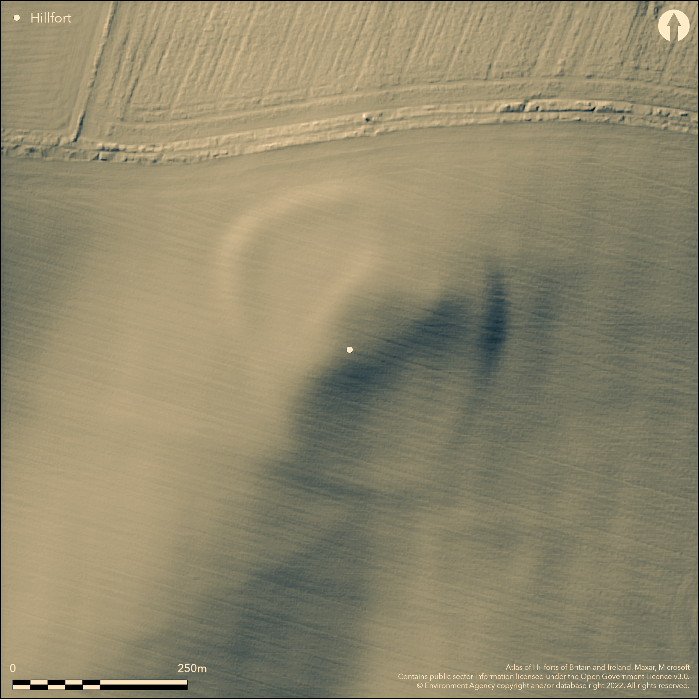
LiDAR 1m DTM Hillshade
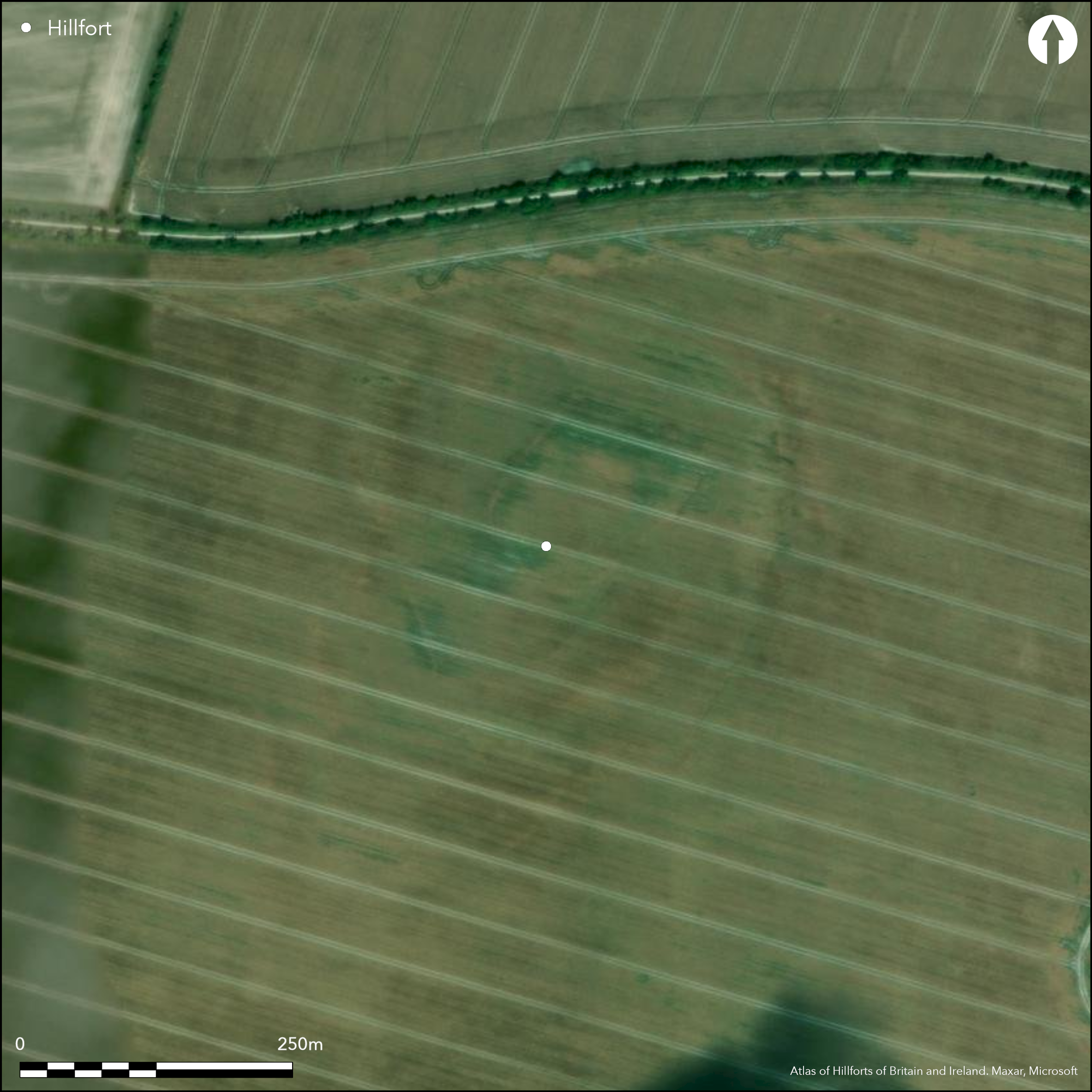
Satellite Imagery
LiDAR 1m DTM Hillshade
Satellite Imagery
Scroll left/right to view further images.
HER: Oxfordshire 10556 (MOX10014)
NMR: SU 38 NW 5 (229217)
SM: None
NGR: SU 3143 8630
X: 431430 Y: 186300 (OSGB36)
Situated on a slight hill at the N edge of the chalk downland scarp overlooking Kingston Lisle and the Vale of the White Horse. First mentioned in an Anglo Saxon charter of 963. A univallate enclosure with a single ditch of 3.5ha in an arable field and now completely ploughed away but visible on aerial photographs. The hillfort replaced a middle/late Bronze Age enclosure (dated by Needham and Ambers 1994) and in turn has a Romano-British enclosure attached to its E side. Two campaigns of excavations (Piggott and Piggott 1940; Bradley and Ellison 1975) concentrated mainly on the Bronze Age enclosure but showed the hillfort rampart to be 7.5m wide, probably a simple dump construction, and the ditch flat-bottomed, 7.5m wide and 2.1m deep. Two original entrances to the W and S, the W subsequently blocked. Dated from early Iron Age pottery in the ditch and the excavators suggest the hillfort may have been short-lived and perhaps even unfinished. No evidence for internal features.
Citizen Science: ✗
Reliability of Data: Confirmed
Reliability of Interpretation: Confirmed
X: -172309 Y: 6723579 (EPSG: 3857)
Longitude: -1.547874196801596 Latitude: 51.57464679282594 (EPSG:4326)
Country: England; None
Current County or Unitary Authority: Oxfordshire
Historic County: Berkshire
Current Parish/Community/Council/Townland: Uffington; Kingston Lisle
None
| Extant | ✗ |
| Cropmark | ✓ |
| Likely Destroyed | ✗ |
Ploughed out but visible on aerial photograph, ramparts survive as very low banks in places maximum of c.1m high.
| Woodland | ✗ |
| Commercial Forestry Plantation | ✗ |
| Parkland | ✗ |
| Pasture (Grazing) | ✗ |
| Arable | ✓ |
| Scrub/Bracken | ✗ |
| Bare Outcrop | ✗ |
| Heather/Moorland | ✗ |
| Heath | ✗ |
| Built-up | ✗ |
| Coastal Grassland | ✗ |
| Other | ✗ |
A contour fort positioned on the top of the chalk downland escarpment, views to the N over the Vale of the White Horse, in other directions over the downs.
| Contour Fort | ✓ |
| Partial Contour Fort | ✗ |
| Promontory Fort | ✗ |
| Hillslope Fort | ✗ |
| Level Terrain Fort | ✗ |
| Marsh Fort | ✗ |
| Multiple Enclosure Fort | ✗ |
| Hilltop | ✗ |
| Coastal Promontory | ✗ |
| Inland Promontory | ✗ |
| Valley Bottom | ✗ |
| Knoll/Hillock/Outcrop | ✗ |
| Ridge | ✗ |
| Cliff/Plateau-edge/Scarp | ✓ |
| Hillslope | ✗ |
| Lowland | ✗ |
| Spur | ✗ |
Dominant Topographic Feature: On the chalk scarp overlooking the Vale of the White Horse
| North | ✗ |
| Northeast | ✗ |
| East | ✗ |
| Southeast | ✗ |
| South | ✗ |
| Southwest | ✗ |
| West | ✗ |
| Northwest | ✗ |
| Level | ✓ |
Altitude: 238.0m
Boundary Type: Parish/Townland
Early Iron Age pottery in ditch fill, hillfort may be short-lived and a suggestion it is unfinished (Bradley and Ellison 1975). Replaces a middle/late Bronze Age enclosure, replaced by Romano-British enclosure.
Reliability: B - Medium
| Pre 1200BC | ✗ |
| 1200BC - 800BC | ✗ |
| 800BC - 400BC | ✓ |
| 400BC - AD50 | ✗ |
| AD50 - AD400 | ✗ |
| AD400 - AD 800 | ✗ |
| Post AD800 | ✗ |
| Unknown | ✗ |
| Pre Hillfort: | None |
| Post Hillfort: | None |
| Artefactual: | Pottery from excavation |
First mentioned in an Anglo Saxon charter of 963. 1938 and 1939, Piggott and Piggott (1940), three sections through the hillfort ramparts. Bradley and Ellison (1975) excavations mainly on the inner Bronze Age enclosure, field walking survey of surrounding area plus comments on earlier work.
| 1st Identified Written Reference (963): | Anglo Saxon charter |
| Other (1974): | Fieldwalking, Bradley and Ellison 1975 |
| Other (2003): | Visited by Hillfort Study Group |
| Excavation (None): | Piggott and Piggott 1940. |
| Excavation (None): | Bradley and Ellison 1975 |
No evidence for internal features of the hillfort
None
| None | ✓ |
| Spring | ✗ |
| Stream | ✗ |
| Pool | ✗ |
| Flush | ✗ |
| Well | ✗ |
| Other | ✗ |
None
| No Known Features | ✓ |
| Round Stone Structures | ✗ |
| Rectangular Stone Structures | ✗ |
| Curvilinear Platforms | ✗ |
| Other Roundhouse Evidence | ✗ |
| Pits | ✗ |
| Quarry Hollows | ✗ |
| Other | ✗ |
None
| No Known Excavation | ✓ |
| Pits | ✗ |
| Postholes | ✗ |
| Roundhouses | ✗ |
| Rectangular Structures | ✗ |
| Roads/Tracks | ✗ |
| Quarry Hollows | ✗ |
| Other | ✗ |
| Nothing Found | ✗ |
None
| No Known Geophysics | ✓ |
| Pits | ✗ |
| Roundhouses | ✗ |
| Rectangular Structures | ✗ |
| Roads/Tracks | ✗ |
| Quarry Hollows | ✗ |
| Other | ✗ |
| Nothing Found | ✗ |
None
| No Known Finds | ✓ |
| Pottery | ✗ |
| Metal | ✗ |
| Metalworking | ✗ |
| Human Bones | ✗ |
| Animal Bones | ✗ |
| Lithics | ✗ |
| Environmental | ✗ |
| Other | ✗ |
None
| APs Not Checked | ✗ |
| None | ✓ |
| Roundhouses | ✗ |
| Rectangular Structures | ✗ |
| Pits | ✗ |
| Postholes | ✗ |
| Roads/Tracks | ✗ |
| Other | ✗ |
Initially two, W and S, the W subsequently blocked
| 2: | None |
| 2: | None |
Guard Chambers: ✗
Chevaux de Frise: ✗
| 1. Simple Gap (South): | Simple gap to S |
| 2. Simple Gap (West): | Blocked entrance to W |
| 2. Blocked (West): | None |
Univallate with a single ditch for the entire circuit, excavation (Piggott and Piggott 1940) suggests rampart is c7.5m wide with no revetment and the ditch is flat-bottomed, 7.5m wide, 2.1m deep, possibly unfinished.
| Area 1: | 3.5ha. |
| Total: | 3.5ha. |
Total Footprint Area: Noneha.
None
| ✗ | None |
| ✓ | None |
| NE Quadrant: | 1 |
| SE Quadrant: | 1 |
| SW Quadrant: | 1 |
| NW Quadrant: | 1 |
| Total: | 1 |
| Partial Univallate | ✗ |
| Univallate | ✓ |
| Partial Bivallate | ✗ |
| Bivallate | ✗ |
| Partial Multivallate | ✗ |
| Multivallate | ✗ |
| Unknown | ✗ |
| Partial Univallate | ✗ |
| Univallate | ✗ |
| Partial Bivallate | ✗ |
| Bivallate | ✗ |
| Partial Multivallate | ✗ |
| Multivallate | ✗ |
Earthen bank but mostly ploughed away
| None | ✗ |
| Earthen Bank | ✓ |
| Stone Wall | ✗ |
| Rubble | ✗ |
| Wall-walk | ✗ |
| Evidence of Timber | ✗ |
| Vitrification | ✗ |
| Other Burning | ✗ |
| Palisade | ✗ |
| Counter Scarp Bank | ✗ |
| Berm | ✗ |
| Unfinished | ✗ |
| Other | ✗ |
Mostly removed, suggested by excavation to be 7.5m wide with no revetment
| None | ✗ |
| Earthen Bank | ✓ |
| Stone Wall | ✗ |
| Murus Duplex | ✗ |
| Timber-framed | ✗ |
| Timber-laced | ✗ |
| Vitrification | ✗ |
| Other Burning | ✗ |
| Palisade | ✗ |
| Counter Scarp Bank | ✗ |
| Berm | ✗ |
| Unfinished | ✗ |
| No Known Excavation | ✗ |
| Other | ✗ |
| ✗ | None |
| ✓ | One ditch for entire circuit, flat-bottomed, 7.5m wide, 2.1m deep. |
Number of Ditches: 1
| ✗ | None |
Piggott, C. and Piggott, S. 1940. Excavations at Rams Hill, Uffington, Berkshire. Antiq J, 20, 465-80.
Bradley, R. and Ellison, A. 1975. Rams Hill. Oxford: BAR Brit Ser 19.
Needham, S. and Ambers, J, 1994. Redating Rams Hill and reconsidering Bronze Age enclosure, Proc Prehist Soc, 60, 225-243.
Atlas of Hillforts:
Wikidata:
This work is licensed under CC BY-SA 4.0![]()
![]()
![]() and should be cited as:
and should be cited as:
Lock, Gary and Ralston, Ian. 2024. Atlas of Hillforts of Britain and Ireland. Available at: https://hillforts.arch.ox.ac.uk
Document Version 1.1