LiDAR 1m DTM Hillshade
Satellite Imagery
LiDAR 1m DTM Hillshade
Satellite Imagery
Scroll left/right to view further images.
HER: Oxfordshire 3150 (MOX14)
NMR: SU 59 SE 3 (238029)
SM: 1006364
NGR: SU 5738 9358
X: 457350 Y: 193650 (OSGB36)
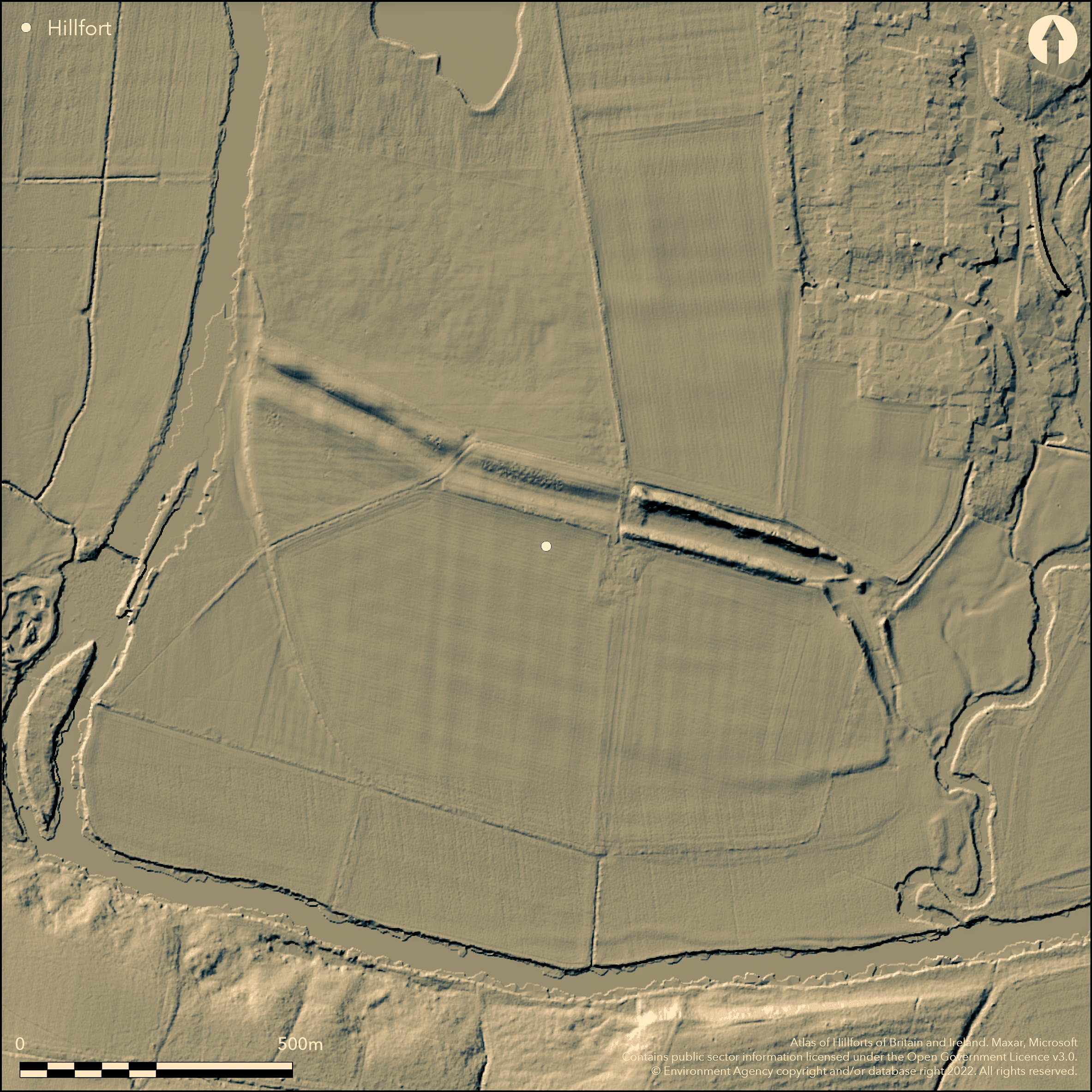
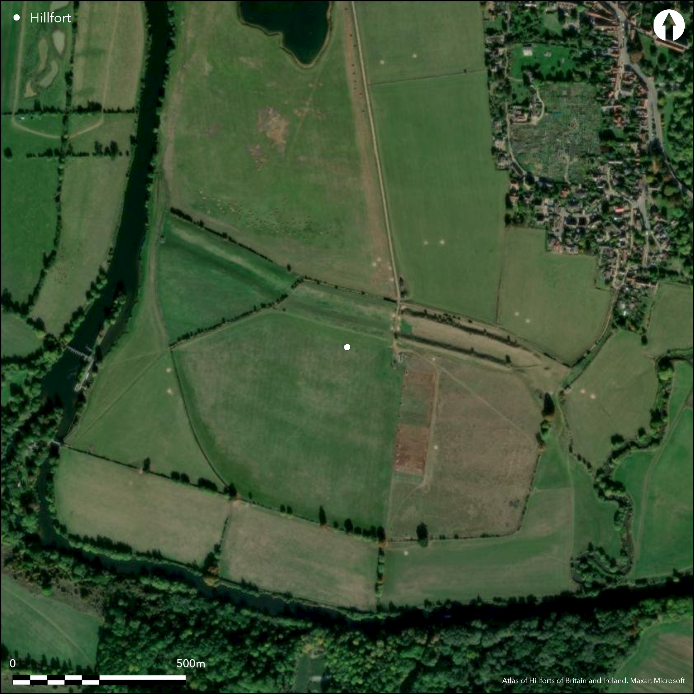
S of Dorchester-on-Thames, a low-lying enclosure formed by two large banks which cut off the promontory between the Rivers Thames and Thame, enclosing c.46ha. Shown on 1st Ed. OS map (1885-1900). Two banks are up to c5m high in places, the large ditch between the two c.16m wide which may have contained water diverted from the river originally, a smaller ditch on the outside. Original entrance possibly at the E where the ramparts turn inwards at the River Thame, at least four other breaks through the ramparts are due to 19th century destruction, current damage by animals. Aerial photographic evidence shows intense occupation within part of the interior; 66 hut circles, 19 enclosures and numerous ditches and scatters of pits (verified in 2016 by geophysics). One minor 19th century excavation through the outer bank. This may be a promontory fort or an enclosed oppidum, the latter argued based on parallels such as Abingdon and the density of occupation features, late Iron Age material and proximity to the Roman town of Dorchester (Cunliffe 1976).
Citizen Science: ✗
Reliability of Data: Confirmed
Reliability of Interpretation: Unconfirmed
X: -130542 Y: 6735058 (EPSG: 3857)
Longitude: -1.172678932231412 Latitude: 51.638690720044195 (EPSG:4326)
Country: England
Current County or Unitary Authority: Oxfordshire
Historic County: Berkshire
Current Parish/Community/Council/Townland: Dorchester
None
| Extant | ✓ |
| Cropmark | ✗ |
| Likely Destroyed | ✗ |
Banks and ditches survive although damaged, mainly through 19th century destruction and current animal activity, interior has been extensively ploughed
| Woodland | ✗ |
| Commercial Forestry Plantation | ✗ |
| Parkland | ✗ |
| Pasture (Grazing) | ✓ |
| Arable | ✓ |
| Scrub/Bracken | ✗ |
| Bare Outcrop | ✗ |
| Heather/Moorland | ✗ |
| Heath | ✗ |
| Built-up | ✗ |
| Coastal Grassland | ✗ |
| Other | ✗ |
Earthworks cut off a promontory defined by the River Thames to S and W, River Thame to E.
| Contour Fort | ✗ |
| Partial Contour Fort | ✗ |
| Promontory Fort | ✓ |
| Hillslope Fort | ✗ |
| Level Terrain Fort | ✗ |
| Marsh Fort | ✗ |
| Multiple Enclosure Fort | ✗ |
| Hilltop | ✗ |
| Coastal Promontory | ✗ |
| Inland Promontory | ✗ |
| Valley Bottom | ✓ |
| Knoll/Hillock/Outcrop | ✗ |
| Ridge | ✗ |
| Cliff/Plateau-edge/Scarp | ✗ |
| Hillslope | ✗ |
| Lowland | ✗ |
| Spur | ✗ |
Dominant Topographic Feature: Good views across the River Thames and its floodplain
| North | ✗ |
| Northeast | ✗ |
| East | ✗ |
| Southeast | ✗ |
| South | ✗ |
| Southwest | ✗ |
| West | ✗ |
| Northwest | ✗ |
| Level | ✓ |
Altitude: 47.0m
N/A
Earthworks and internal features (roundhouses) suggest Iron Age, small amounts of pottery, late Iron Age due to coins
Reliability: C - Low
| Pre 1200BC | ✗ |
| 1200BC - 800BC | ✗ |
| 800BC - 400BC | ✓ |
| 400BC - AD50 | ✓ |
| AD50 - AD400 | ✗ |
| AD400 - AD 800 | ✗ |
| Post AD800 | ✗ |
| Unknown | ✗ |
| Pre Hillfort: | None |
| Post Hillfort: | None |
| Artefactual: | Small amounts of pottery, coins |
| Morphology/Earthwork/Typology: | Earthworks and internal features (roundhouses) suggest Iron Age |
In Aubrey's Monumenta Britannica (1665-1693). Shown on 1st Ed. OS map (1885-1900). Small-scale cutting through the outer bank in 1870 (Sutton 1966). Geophysics 2016 (William Wintle).
| Excavation (1870): | None |
| Geophysical Survey (2016): | None |
| 1st Identified Written Reference (None): | None |
| 1st Identified Map Depiction (None): | 1st Ed. OS |
Aerial photographic evidence for intense occupation; 66 hut circles, 19 enclosures and numerous ditches and scatters of pits (verified by geophysics in 2016).
None but at the confluence of the Rivers Thames and Thame.
| None | ✓ |
| Spring | ✗ |
| Stream | ✗ |
| Pool | ✗ |
| Flush | ✗ |
| Well | ✗ |
| Other | ✗ |
None
| No Known Features | ✓ |
| Round Stone Structures | ✗ |
| Rectangular Stone Structures | ✗ |
| Curvilinear Platforms | ✗ |
| Other Roundhouse Evidence | ✗ |
| Pits | ✗ |
| Quarry Hollows | ✗ |
| Other | ✗ |
None
| No Known Excavation | ✓ |
| Pits | ✗ |
| Postholes | ✗ |
| Roundhouses | ✗ |
| Rectangular Structures | ✗ |
| Roads/Tracks | ✗ |
| Quarry Hollows | ✗ |
| Other | ✗ |
| Nothing Found | ✗ |
None
| No Known Geophysics | ✗ |
| Pits | ✗ |
| Roundhouses | ✗ |
| Rectangular Structures | ✗ |
| Roads/Tracks | ✗ |
| Quarry Hollows | ✗ |
| Other | ✓ |
| Nothing Found | ✗ |
Iron Age coins
| No Known Finds | ✗ |
| Pottery | ✓ |
| Metal | ✗ |
| Metalworking | ✗ |
| Human Bones | ✗ |
| Animal Bones | ✗ |
| Lithics | ✗ |
| Environmental | ✗ |
| Other | ✓ |
66 hut circles, 19 enclosures and numerous ditches and scatters of pits visible on aerial photographs
| APs Not Checked | ✗ |
| None | ✗ |
| Roundhouses | ✓ |
| Rectangular Structures | ✗ |
| Pits | ✓ |
| Postholes | ✗ |
| Roads/Tracks | ✗ |
| Other | ✓ |
Original entrance possibly at the E where the ramparts turn inwards at the River Thame. At least four other breaks through the ramparts are modern.
| 5: | None |
| 2: | None |
Guard Chambers: ✗
Chevaux de Frise: ✗
| 1. In-turned (East): | None |
Two large banks up to c5m high cutting off the promontory formed by the Rivers Thames and Thame, large ditch between the two c.16m wide which may have contained water diverted from the river originally, a smaller ditch on the outside.
| Area 1: | 46.0ha. |
| Total: | 46.0ha. |
Total Footprint Area: Noneha.
None
| ✗ | None |
| ✗ | None |
| NE Quadrant: | 2 |
| SE Quadrant: | 0 |
| SW Quadrant: | 0 |
| NW Quadrant: | 2 |
| Total: | 2 |
| Partial Univallate | ✗ |
| Univallate | ✗ |
| Partial Bivallate | ✓ |
| Bivallate | ✗ |
| Partial Multivallate | ✗ |
| Multivallate | ✗ |
| Unknown | ✗ |
| Partial Univallate | ✗ |
| Univallate | ✗ |
| Partial Bivallate | ✗ |
| Bivallate | ✗ |
| Partial Multivallate | ✗ |
| Multivallate | ✗ |
None
| None | ✗ |
| Earthen Bank | ✓ |
| Stone Wall | ✗ |
| Rubble | ✗ |
| Wall-walk | ✗ |
| Evidence of Timber | ✗ |
| Vitrification | ✗ |
| Other Burning | ✗ |
| Palisade | ✗ |
| Counter Scarp Bank | ✗ |
| Berm | ✗ |
| Unfinished | ✗ |
| Other | ✗ |
None
| None | ✗ |
| Earthen Bank | ✓ |
| Stone Wall | ✗ |
| Murus Duplex | ✗ |
| Timber-framed | ✗ |
| Timber-laced | ✗ |
| Vitrification | ✗ |
| Other Burning | ✗ |
| Palisade | ✗ |
| Counter Scarp Bank | ✗ |
| Berm | ✗ |
| Unfinished | ✗ |
| No Known Excavation | ✗ |
| Other | ✗ |
| ✗ | None |
| ✓ | None |
Number of Ditches: 2
| ✗ | None |
Page, W. (ed) 1907. The Victoria History of the County of Oxford, Vol II, London, 308.
Sutton, J.E.G. 1966. Iron-Age hill-forts and some other earthworks in Oxfordshire, Oxoniensia, 31, 28-42.
Cunliffe, B. 1976. The origins of urbanisation in Britain, in Cunliffe, B. and Rowley, T. (eds), Oppida in Barbarian Europe, BAR Int Ser 11, 135-161.
Lambrick, G. 2009. Thames Through Time. The archaeology of the gravel terraces of the upper and middle Thames. Late prehistory 1500 BC - AD 50. Oxford: Oxford Archaeology, Thames Valley Landscapes Monograph No. 29, 361-4.
Welch, C. 2014. The destruction of the Dyke Hills, Dorchester-on-Thames. Oxoniensia, 79, 77-95.
Atlas of Hillforts:
Wikidata:
This work is licensed under CC BY-SA 4.0![]()
![]()
![]() and should be cited as:
and should be cited as:
Lock, Gary and Ralston, Ian. 2024. Atlas of Hillforts of Britain and Ireland. Available at: https://hillforts.arch.ox.ac.uk
Document Version 1.1