LiDAR 1m DTM Hillshade
Satellite Imagery
LiDAR 1m DTM Hillshade
Satellite Imagery
Scroll left/right to view further images.
HER: Herefordshire 930 (None)
NMR: SO 64 NE 5 (112198)
SM: 1001739
NGR: SO671457
X: 367106 Y: 245747 (OSGB36)
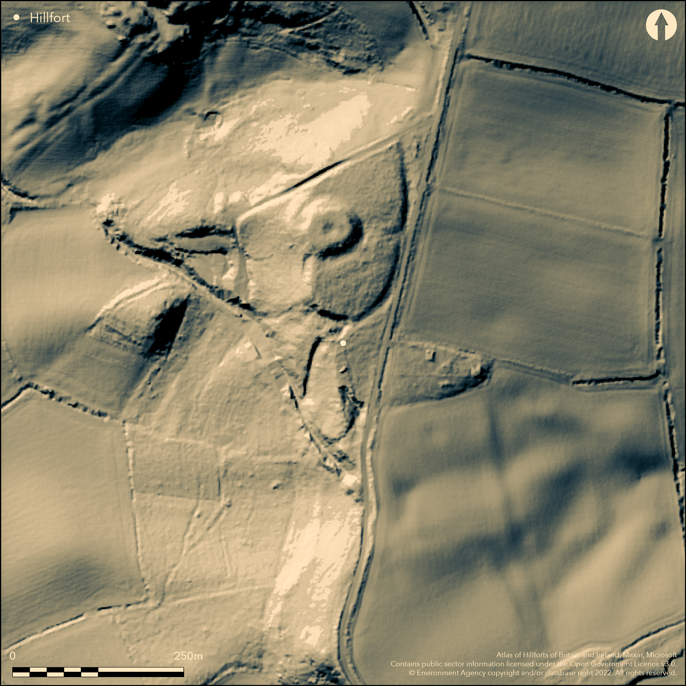
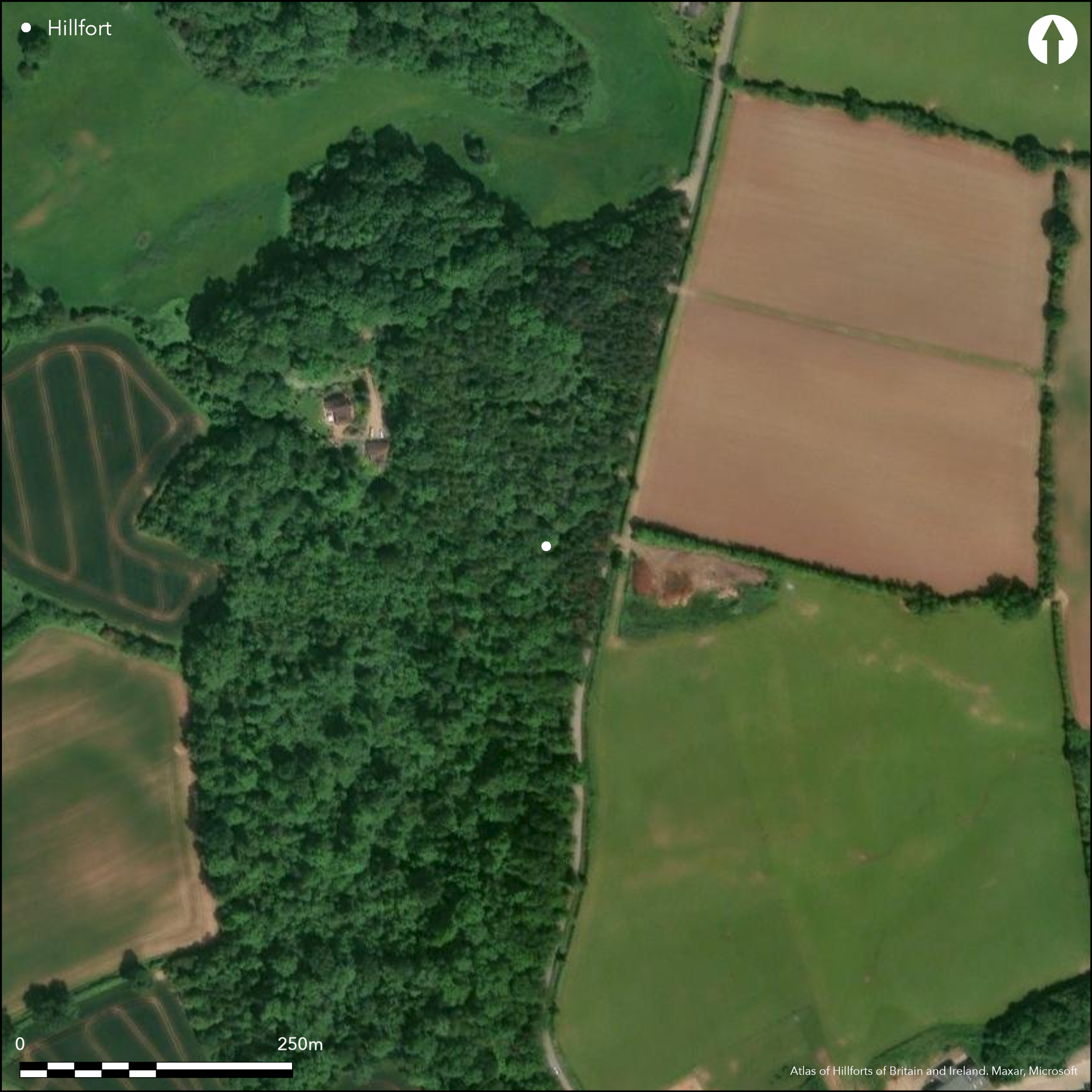
A medieval ringwork and bailey castle located on the site of a possible Iron Age hillfort just E of the church at Castle Frome and on the edge of a N-S W-facing escarpment overlooking the River Frome. A broad oval motte, some 50m in diameter at its base, with surrounding ditch, has two possible baileys to the N and S. There is a scarp on the E and S sides and to the SW of the motte there is a sunkenway, partly protected by a rampart on the W side. There have been no detailed investigations of the nature of the earlier enclosure, but certain factors point to its existence as follows: the way in which the extant remains occupy the site and the shape of the present enclosure; the degree in which the mound is located at one side of the enclosure and the known pattern of medium-sized enclosures in the area. In addition, the site has a clear line of sight to British Camp (Atlas No 0005) on Herefordshire on the top of the Malvern ridge to E. The site is covered with dense undergrowth and trees and this makes interpretation very difficult, if not impossible, in places. As a result no entrances have been determined. The medieval castle was held by the de Lacys, but was in the hands of the King from 1155 to around 1216. Although trees were felled in 1956, replanting, plus impenetrable scrub, makes any features associated with a possible hillfort impossible to ascertained at present and excavation is required. The motte and bailey castle is scheduled and monument numbers above refer to this.
Citizen Science: ✗
Reliability of Data: Unconfirmed
Reliability of Interpretation: Unconfirmed
X: -276267 Y: 6819863 (EPSG: 3857)
Longitude: -2.481744445930345 Latitude: 52.109028717901346 (EPSG:4326)
Country: England
Current County or Unitary Authority: Herefordshire
Historic County: Herefordshire
Current Parish/Community/Council/Townland: Castle Frome
Any features associated with a possible hillfort have not been ascertained at present and excavation is required. Medieval ringwork and bailey castle.
| Extant | ✗ |
| Cropmark | ✗ |
| Likely Destroyed | ✓ |
Although trees were felled in 1956, replanting, plus impenetrable scrub, makes any features associated with a possible hillfort impossible to ascertained at present and excavation is required. Medieval ringwork and bailey castle.
| Woodland | ✓ |
| Commercial Forestry Plantation | ✗ |
| Parkland | ✗ |
| Pasture (Grazing) | ✗ |
| Arable | ✗ |
| Scrub/Bracken | ✓ |
| Bare Outcrop | ✗ |
| Heather/Moorland | ✗ |
| Heath | ✗ |
| Built-up | ✗ |
| Coastal Grassland | ✗ |
| Other | ✓ |
Level terrain fort located on a gently sloping N-S W-facing escarpment overlooking the River Frome.
| Contour Fort | ✗ |
| Partial Contour Fort | ✗ |
| Promontory Fort | ✗ |
| Hillslope Fort | ✗ |
| Level Terrain Fort | ✓ |
| Marsh Fort | ✗ |
| Multiple Enclosure Fort | ✗ |
| Hilltop | ✗ |
| Coastal Promontory | ✗ |
| Inland Promontory | ✗ |
| Valley Bottom | ✗ |
| Knoll/Hillock/Outcrop | ✗ |
| Ridge | ✗ |
| Cliff/Plateau-edge/Scarp | ✓ |
| Hillslope | ✗ |
| Lowland | ✗ |
| Spur | ✗ |
Dominant Topographic Feature: N-S W-facing escarpment overlooking the River Frome.
| North | ✗ |
| Northeast | ✗ |
| East | ✗ |
| Southeast | ✗ |
| South | ✗ |
| Southwest | ✗ |
| West | ✓ |
| Northwest | ✗ |
| Level | ✗ |
Altitude: 155.0m
N/A
Possible hillfort dates not determined, but form of the enclosure site indicates probably Iron Age beneath medieval layers.
Reliability: C - Low
| Pre 1200BC | ✗ |
| 1200BC - 800BC | ✗ |
| 800BC - 400BC | ✗ |
| 400BC - AD50 | ✓ |
| AD50 - AD400 | ✗ |
| AD400 - AD 800 | ✗ |
| Post AD800 | ✓ |
| Unknown | ✗ |
| Pre Hillfort: | None |
| Post Hillfort: | None |
| Morphology/Earthwork/Typology: | Definite medieval ringwork and bailey castle |
| Morphology/Earthwork/Typology: | Possible hillfort dates not determined, but form of the enclosure site indicates probably Iron Age. |
No investigations of possible hillfort, but referred to in HER.
None.
None determined at present, but the fact that there was a medieval ringwork and bailey castle on site suggests an on site water supply.
| None | ✓ |
| Spring | ✗ |
| Stream | ✗ |
| Pool | ✗ |
| Flush | ✗ |
| Well | ✗ |
| Other | ✗ |
None
| No Known Features | ✓ |
| Round Stone Structures | ✗ |
| Rectangular Stone Structures | ✗ |
| Curvilinear Platforms | ✗ |
| Other Roundhouse Evidence | ✗ |
| Pits | ✗ |
| Quarry Hollows | ✗ |
| Other | ✗ |
None
| No Known Excavation | ✓ |
| Pits | ✗ |
| Postholes | ✗ |
| Roundhouses | ✗ |
| Rectangular Structures | ✗ |
| Roads/Tracks | ✗ |
| Quarry Hollows | ✗ |
| Other | ✗ |
| Nothing Found | ✗ |
None
| No Known Geophysics | ✓ |
| Pits | ✗ |
| Roundhouses | ✗ |
| Rectangular Structures | ✗ |
| Roads/Tracks | ✗ |
| Quarry Hollows | ✗ |
| Other | ✗ |
| Nothing Found | ✗ |
None
| No Known Finds | ✓ |
| Pottery | ✗ |
| Metal | ✗ |
| Metalworking | ✗ |
| Human Bones | ✗ |
| Animal Bones | ✗ |
| Lithics | ✗ |
| Environmental | ✗ |
| Other | ✗ |
None
| APs Not Checked | ✓ |
| None | ✗ |
| Roundhouses | ✗ |
| Rectangular Structures | ✗ |
| Pits | ✗ |
| Postholes | ✗ |
| Roads/Tracks | ✗ |
| Other | ✗ |
The impenetrable nature of undergrowth and lack of detailed investigation makes the details of any early entrance difficult to ascertain at present. Inward turn of outer bank midway along the E side of the bailey may represent the site of an original entrance or gate into the castle. Whether this is the site of an earlier entrance has not been determined.
| 1: | None |
| 2: | Possible entrance into the enclosure. |
Guard Chambers: ✗
Chevaux de Frise: ✗
| 1. In-turned (East): | Inward turn of outer bank midway along the E side of the bailey may represent the site of an original entrance or gate into the castle. Whether this is the site of an earlier entrance has not been determined. |
There have been no detailed investigations of the nature of the earlier enclosure, but certain factors point to its existence as follows: the way in which the extant remains occupy the site and the shape of the present enclosure; the degree in which the mound is located at one side of the enclosure and the known pattern of medium-sized enclosures in the area. In addition, the site has a clear line of sight to British Camp (Atlas No 0005) on the top of the Malvern ridge.
| Area 1: | Noneha. |
| Total: | Noneha. |
Total Footprint Area: Noneha.
None
| ✗ | The impenetrable nature of undergrowth and lack of detailed investigation makes the details of any area impossible to ascertain at present. |
| ✗ | The impenetrable nature of undergrowth and lack of detailed investigation makes the details of any early ramparts impossible to ascertain at present. |
| NE Quadrant: | None |
| SE Quadrant: | None |
| SW Quadrant: | None |
| NW Quadrant: | None |
| Total: | None |
| Partial Univallate | ✗ |
| Univallate | ✗ |
| Partial Bivallate | ✗ |
| Bivallate | ✗ |
| Partial Multivallate | ✗ |
| Multivallate | ✗ |
| Unknown | ✓ |
| Partial Univallate | ✗ |
| Univallate | ✗ |
| Partial Bivallate | ✗ |
| Bivallate | ✗ |
| Partial Multivallate | ✗ |
| Multivallate | ✗ |
None
| None | ✓ |
| Earthen Bank | ✗ |
| Stone Wall | ✗ |
| Rubble | ✗ |
| Wall-walk | ✗ |
| Evidence of Timber | ✗ |
| Vitrification | ✗ |
| Other Burning | ✗ |
| Palisade | ✗ |
| Counter Scarp Bank | ✗ |
| Berm | ✗ |
| Unfinished | ✗ |
| Other | ✗ |
None
| None | ✗ |
| Earthen Bank | ✗ |
| Stone Wall | ✗ |
| Murus Duplex | ✗ |
| Timber-framed | ✗ |
| Timber-laced | ✗ |
| Vitrification | ✗ |
| Other Burning | ✗ |
| Palisade | ✗ |
| Counter Scarp Bank | ✗ |
| Berm | ✗ |
| Unfinished | ✗ |
| No Known Excavation | ✓ |
| Other | ✗ |
| ✗ | None |
| ✗ | None |
Number of Ditches: 0
| ✗ | None |
RCHME 1932. An Inventory of the Historical Monuments in Herefordshire, 2, 49, London: HMSO.
White, P. 2011. The Frome Valley, Herefordshire: Archaeology, Landscape Change and Conservation, Herefordshire Studies in Archaeology: Series 3. Herefordshire Archaeology.
Atlas of Hillforts:
Wikidata:
This work is licensed under CC BY-SA 4.0![]()
![]()
![]() and should be cited as:
and should be cited as:
Lock, Gary and Ralston, Ian. 2024. Atlas of Hillforts of Britain and Ireland. Available at: https://hillforts.arch.ox.ac.uk
Document Version 1.1