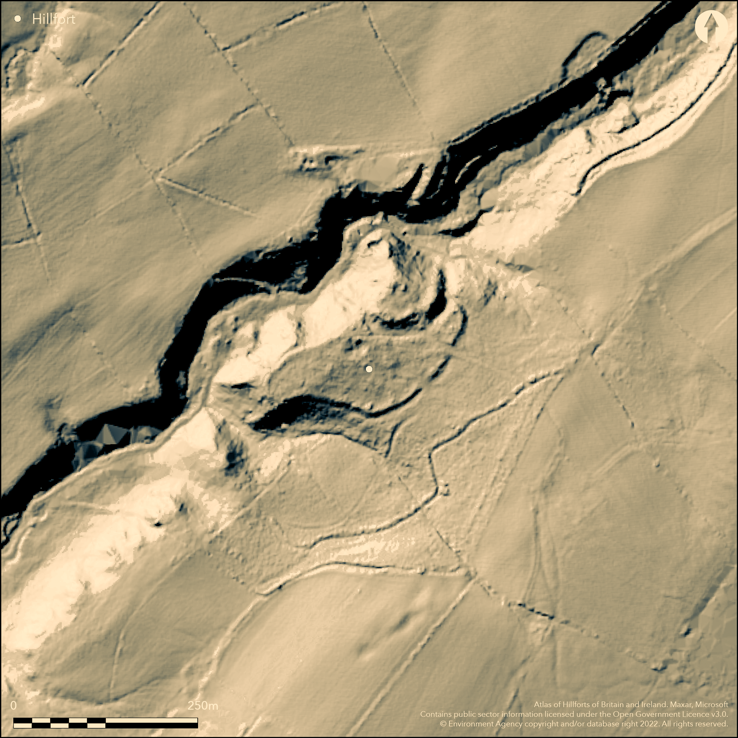
LiDAR 1m DTM Hillshade

Satellite Imagery
LiDAR 1m DTM Hillshade
Satellite Imagery
Scroll left/right to view further images.
HER: Shropshire 1327 (None)
NMR: SO 39 NW 6 (107460)
SM: 1020150
NGR: SO34449765
X: 334440 Y: 297650 (OSGB36)
Earthwork and buried remains of a small, univallate, crescent-shaped, inland promontory hillfort which encloses a medieval ringwork and bailey and post-medieval mining settlement, and sited on a projecting cliff edge shelf above steep slopes on the NW side of Brooks Hill, just to the W of the Stiperstones and in a commanding position with far reaching views to the N and W. Above the Ritton Castle Mine, the ground falls steeply to the NW with a precipitous ravine on the NE. Hillfort is sub-rectangular in plan measuring 116m by 215m enclosing c. 1.3ha, and where the ground falls steeply away scarp defences are bounded by an external terrace or berm c. 1m-2m wide. To the E, where the ground rises gently to the SE, the hillfort is defined by a bank c. 6m wide and 1m high and an external ditch 6m-8m wide and 1m in depth. To the S the ditch is bounded by a steep scarp which continues along the W and N sides of the shelf and to the NE where it turns outwards to join the scarp. Later, in the medieval period, the hillfort circuit was incorporated into the design of a ringwork and bailey, the principal residence or caput of Ritton Manor, first recorded in 1203 when Robert Corbert of Caus granted the site to Buildwas Abbey. The N part of the ringwork uses the steep scarp which originally defended the NW circuit of the hillfort and the position of the ringwork suggests that the rest of the hillfort served as a bailey and would have contained a series of ancillary buildings and stores. The S side of the ringwork has sizeable defences on its S side with curving rampart of earth and stone c. 2.2m high and with a 8m-10m wide ditch, some 2.2m deep. Later a small lead mining settlement is shown on the 1882 OS map and detritus from this remains on the site, including two small quarries, trackways and a square embanked enclosure. The entrance into the hillfort enclosure was via a causeway c. 5m in width through the NE part of the defences. The site is very overgrown. Few investigations. On 1st Ed OS map (1882).
Citizen Science: ✗
Reliability of Data: Confirmed
Reliability of Interpretation: Confirmed
X: -330488 Y: 6904342 (EPSG: 3857)
Longitude: -2.968820984042534 Latitude: 52.572675975887854 (EPSG:4326)
Country: England
Current County or Unitary Authority: Shropshire
Historic County: Shropshire
Current Parish/Community/Council/Townland: Worthen with Shelve
The fort has been incorporated into the design of the medieval ringwork and bailey castle and later 19th century lead mining settlement was located in the interior, with associated detritus, trackways, two small quarries and a squared embanked enclosure.
| Extant | ✓ |
| Cropmark | ✗ |
| Likely Destroyed | ✗ |
Very overgrown. A commercial conifer plantation was due to be felled in 2012. Medieval ringwork and bailey castle and later 19th century lead mining settlement was located in the interior.
| Woodland | ✓ |
| Commercial Forestry Plantation | ✓ |
| Parkland | ✗ |
| Pasture (Grazing) | ✗ |
| Arable | ✗ |
| Scrub/Bracken | ✓ |
| Bare Outcrop | ✗ |
| Heather/Moorland | ✗ |
| Heath | ✗ |
| Built-up | ✓ |
| Coastal Grassland | ✗ |
| Other | ✓ |
Small inland promontory fort strategically sited above steep slopes on a projecting cliff edge shelf on the NW side of Brooks Hill, just to the W of the Stiperstones and in a commanding position with far reaching views to the N and W.
| Contour Fort | ✗ |
| Partial Contour Fort | ✗ |
| Promontory Fort | ✓ |
| Hillslope Fort | ✗ |
| Level Terrain Fort | ✗ |
| Marsh Fort | ✗ |
| Multiple Enclosure Fort | ✗ |
| Hilltop | ✗ |
| Coastal Promontory | ✗ |
| Inland Promontory | ✓ |
| Valley Bottom | ✗ |
| Knoll/Hillock/Outcrop | ✗ |
| Ridge | ✗ |
| Cliff/Plateau-edge/Scarp | ✓ |
| Hillslope | ✗ |
| Lowland | ✗ |
| Spur | ✓ |
Dominant Topographic Feature: Projecting cliff edge shelf on the very steep NW slopes of Brooks Hill.
| North | ✗ |
| Northeast | ✗ |
| East | ✗ |
| Southeast | ✗ |
| South | ✗ |
| Southwest | ✗ |
| West | ✗ |
| Northwest | ✗ |
| Level | ✓ |
Altitude: 310.0m
N/A
Date of hillfort unknown, but possibly late Bronze Age to early Iron Age. Later medieval ringwork and bailey castle c. 13th century and 19th century used hillfort as a bailey.
Reliability: D - None
| Pre 1200BC | ✗ |
| 1200BC - 800BC | ✗ |
| 800BC - 400BC | ✗ |
| 400BC - AD50 | ✗ |
| AD50 - AD400 | ✗ |
| AD400 - AD 800 | ✗ |
| Post AD800 | ✗ |
| Unknown | ✓ |
| Pre Hillfort: | None |
| Post Hillfort: | Later medieval ringwork and bailey castle and 19th century lead mining settlement. |
| Morphology/Earthwork/Typology: | Later medieval ringwork and bailey castle and 19th century lead mining settlement. |
On 1st Ed OS map (1882). Field observation Ordnance Survey 1973. Field observation Shropshire CC 1981. Shropshire Council survey 2012.
| 1st Identified Map Depiction (1882): | 1st Ed OS |
| Other (1973): | Field observation OS. |
| Other (1981): | Field observation Shropshire CC. |
| Other (2012): | Shropshire Council survey. |
Much later 19th century detritus associated with a lead mining settlement to include two small quarries, trackways and a square embanked enclosure.
Probable later well could indicate earlier water supply on site.
| None | ✗ |
| Spring | ✗ |
| Stream | ✗ |
| Pool | ✗ |
| Flush | ✗ |
| Well | ✓ |
| Other | ✗ |
Much later 19th century detritus associated with a lead mining settlement to include two small quarries, trackways and a square embanked enclosure.
| No Known Features | ✗ |
| Round Stone Structures | ✗ |
| Rectangular Stone Structures | ✗ |
| Curvilinear Platforms | ✗ |
| Other Roundhouse Evidence | ✗ |
| Pits | ✗ |
| Quarry Hollows | ✗ |
| Other | ✓ |
None
| No Known Excavation | ✓ |
| Pits | ✗ |
| Postholes | ✗ |
| Roundhouses | ✗ |
| Rectangular Structures | ✗ |
| Roads/Tracks | ✗ |
| Quarry Hollows | ✗ |
| Other | ✗ |
| Nothing Found | ✗ |
None
| No Known Geophysics | ✓ |
| Pits | ✗ |
| Roundhouses | ✗ |
| Rectangular Structures | ✗ |
| Roads/Tracks | ✗ |
| Quarry Hollows | ✗ |
| Other | ✗ |
| Nothing Found | ✗ |
None
| No Known Finds | ✓ |
| Pottery | ✗ |
| Metal | ✗ |
| Metalworking | ✗ |
| Human Bones | ✗ |
| Animal Bones | ✗ |
| Lithics | ✗ |
| Environmental | ✗ |
| Other | ✗ |
None
| APs Not Checked | ✓ |
| None | ✗ |
| Roundhouses | ✗ |
| Rectangular Structures | ✗ |
| Pits | ✗ |
| Postholes | ✗ |
| Roads/Tracks | ✗ |
| Other | ✗ |
The original entrance into the hillfort enclosure was via a causeway c. 5m in width through the NE part of the defences. Later 4m wide entrance through ringwork defences to provide access within.
| 2: | The exact number of breaks in the ramparts is difficult to ascertain because of later disturbance. Later 4m wide entrance through ringwork defences to provide access within. |
| 2: | Possibly one original entrance to hillfort main enclosure and later 4m wide entrance through ringwork defences to provide access within. |
Guard Chambers: ✗
Chevaux de Frise: ✗
| 1. Simple Gap (East): | Entrance via a causeway c. 5m in width through the NE part of the defences. |
The hillfort is sub-rectangular in plan measuring 116m by 215m enclosing c. 1.3ha and where the ground falls steeply away scarp defences are bounded by an external terrace or berm c. 1m-2m wide. To the E, where the ground rises gently to the SE, the hillfort is defined by a bank c. 6m wide and 1m high and an external ditch 6m-8m wide and 1m in depth. To the S the ditch is bounded by a steep scarp which continues along the W and N sides of the shelf and to the NE where it turns outwards to join the scarp. The S side has sizeable defences on its S side with curving rampart of earth and stone c. 2.2m high and with a 8m-10m wide ditch, some 2.2m deep.
| Area 1: | 1.3ha. |
| Total: | 1.3ha. |
Total Footprint Area: Noneha.
None
| ✓ | The exact area is difficult to ascertain because of the later medieval ringwork and bailey. Possibly phased but difficult to assess. |
| ✗ | The exact circuit is difficult to ascertain because of later disturbance. |
| NE Quadrant: | 1 |
| SE Quadrant: | 1 |
| SW Quadrant: | 1 |
| NW Quadrant: | 1 |
| Total: | 1 |
| Partial Univallate | ✗ |
| Univallate | ✓ |
| Partial Bivallate | ✗ |
| Bivallate | ✗ |
| Partial Multivallate | ✗ |
| Multivallate | ✗ |
| Unknown | ✗ |
| Partial Univallate | ✗ |
| Univallate | ✗ |
| Partial Bivallate | ✗ |
| Bivallate | ✗ |
| Partial Multivallate | ✗ |
| Multivallate | ✗ |
Possible earth and stone construction as is the S bank of the ringwork.
| None | ✗ |
| Earthen Bank | ✓ |
| Stone Wall | ✓ |
| Rubble | ✗ |
| Wall-walk | ✗ |
| Evidence of Timber | ✗ |
| Vitrification | ✗ |
| Other Burning | ✗ |
| Palisade | ✗ |
| Counter Scarp Bank | ✗ |
| Berm | ✗ |
| Unfinished | ✗ |
| Other | ✗ |
None
| None | ✗ |
| Earthen Bank | ✗ |
| Stone Wall | ✗ |
| Murus Duplex | ✗ |
| Timber-framed | ✗ |
| Timber-laced | ✗ |
| Vitrification | ✗ |
| Other Burning | ✗ |
| Palisade | ✗ |
| Counter Scarp Bank | ✗ |
| Berm | ✗ |
| Unfinished | ✗ |
| No Known Excavation | ✓ |
| Other | ✗ |
| ✗ | None |
| ✓ | To the E, where the ground rises gently to the SE, the hillfort is defined by a bank c. 6m wide and 1m high and an external ditch 6-8m wide and 1m in depth. |
Number of Ditches: 1
| ✗ | None |
Dorling, P. and Wigley, A. 2012: Assessment of the archaeological and conservation status of major later prehistoric enclosures in Herefordshire and Shropshire, EH PNUM, Version 3.2, Hereford and Shrewsbury: Herefordshire Council/Shropshire Council.
Hogg, A. H. A. and King, D .J. C. 1963. Early Castles in Wales and the Marches, Arch Camb, 112, 77-124.
Atlas of Hillforts:
Wikidata:
This work is licensed under CC BY-SA 4.0![]()
![]()
![]() and should be cited as:
and should be cited as:
Lock, Gary and Ralston, Ian. 2024. Atlas of Hillforts of Britain and Ireland. Available at: https://hillforts.arch.ox.ac.uk
Document Version 1.1