LiDAR 1m DTM Hillshade
Satellite Imagery
LiDAR 1m DTM Hillshade
Satellite Imagery
Scroll left/right to view further images.
HER: Worcestershire MWR22 (WSM00045)
NMR: SP 06 NE 9 (328657)
SM: 1005309
NGR: SP0655 6940
X: 406538 Y: 269421 (OSGB36)
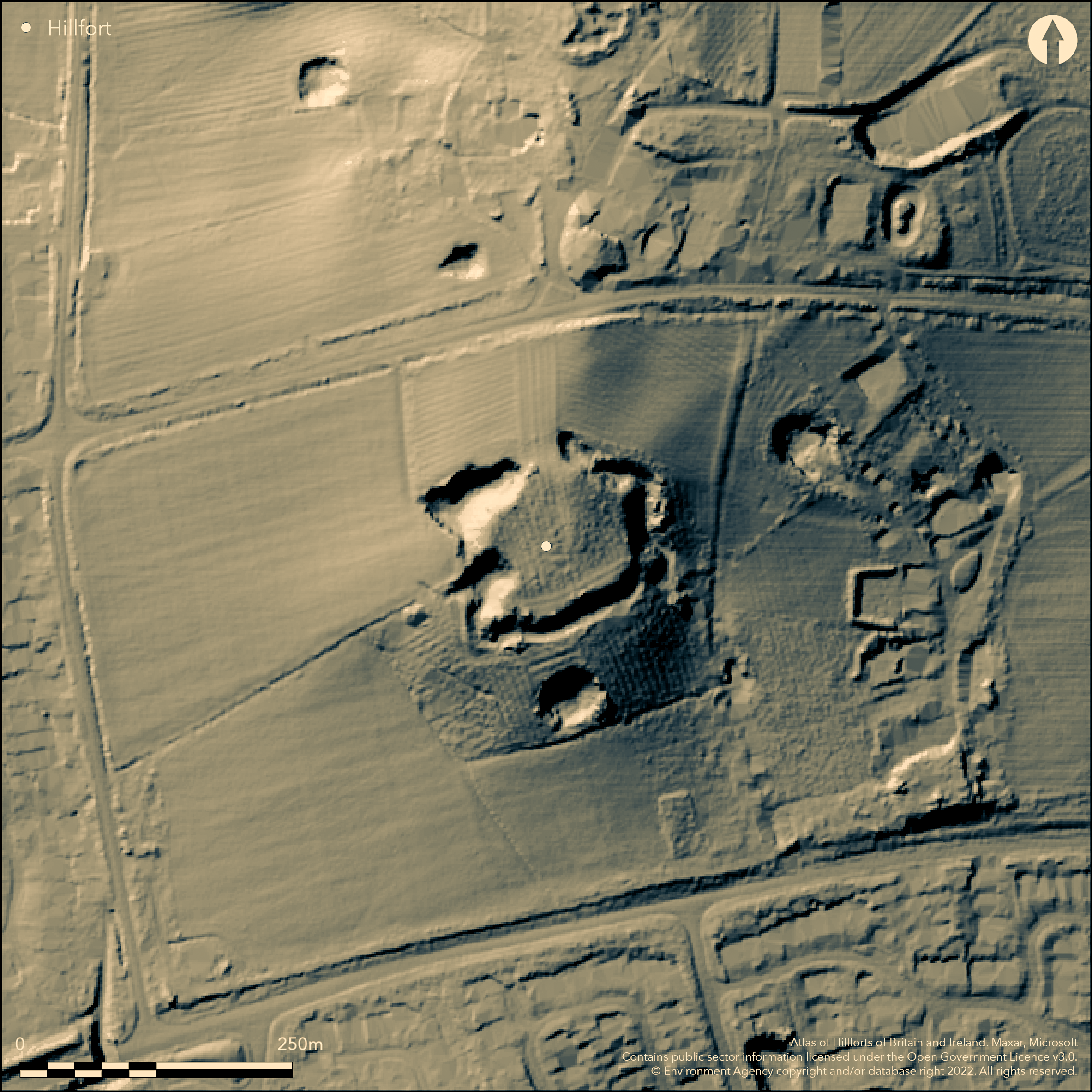
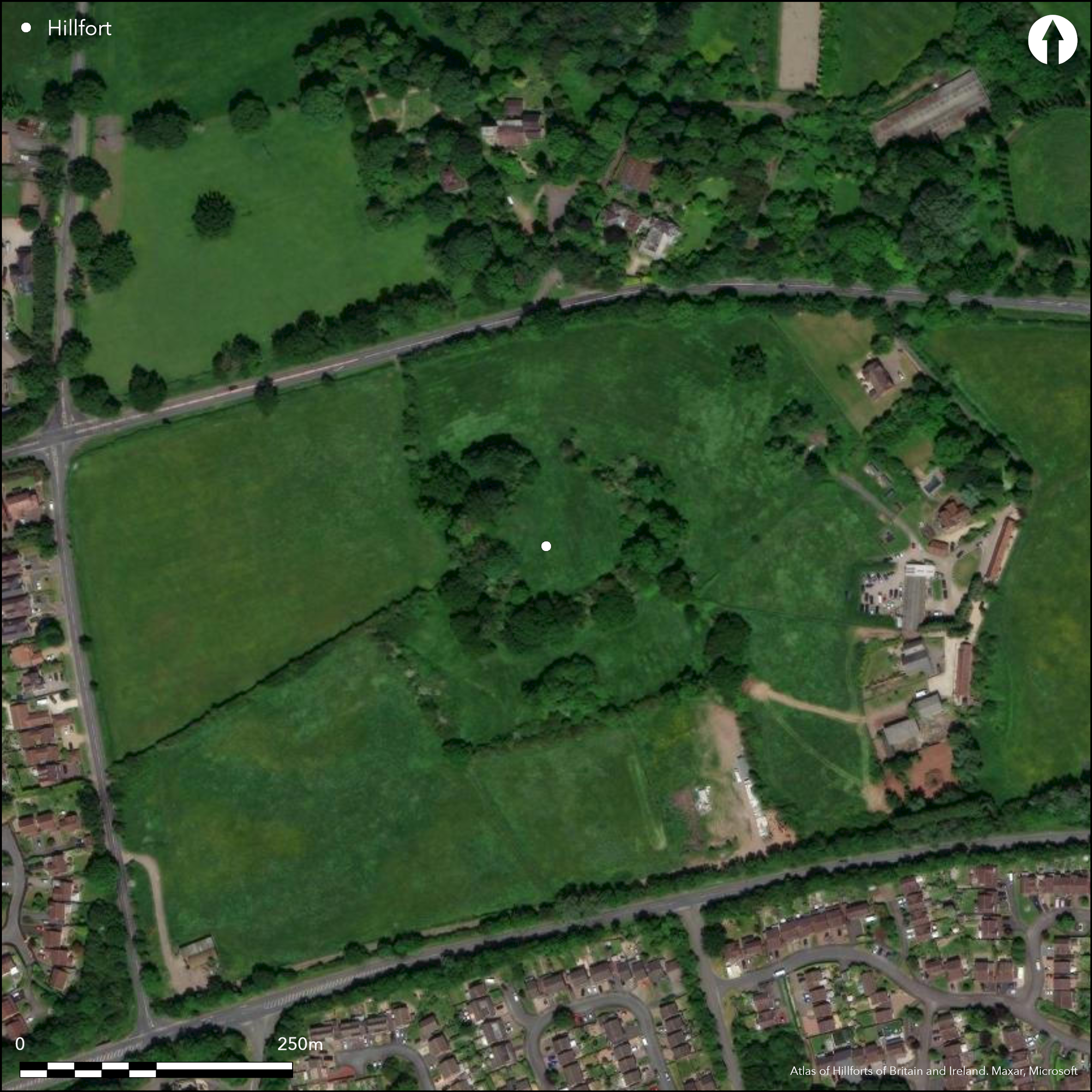
Possible oval, univallate, hillfort, latterly 13th century strongpoint and/or manor house. On 1st Ed OS map (1885-1900). Manor owned by Pershore Abbey at Domesday, later passed to the Beauchamps. Sited on a spur just below summit of hill in commanding position overlooking the River Arrow valley close to Roman Ryknield Street. S side best preserved as scarp with ditch and counterscarp bank. W and E sides have scarp and ditch. Possible entrance to the N. Site much cut into by later marl pit, especially on W. Little visible of medieval ruins and detailed plan of enclosure and the exact line of the earlier enclosure to be determined, but site scheduled. Some chance finds of black pottery and fragment of possible unglazed cinerary urn found in ditch side. General scrub and tree growth.,
Citizen Science: ✗
Reliability of Data: Confirmed
Reliability of Interpretation: Unconfirmed
X: -212120 Y: 6858707 (EPSG: 3857)
Longitude: -1.9055083551713157 Latitude: 52.32281726604748 (EPSG:4326)
Country: England
Current County or Unitary Authority: Worcestershire
Historic County: Worcestershire
Current Parish/Community/Council/Townland: Beoley
Much cut into by later marl pit. Medieval stronghold or manor house on site.
| Extant | ✓ |
| Cropmark | ✗ |
| Likely Destroyed | ✗ |
General scrub and tree growth. Medieval stronghold or manor house on site (little visible).
| Woodland | ✓ |
| Commercial Forestry Plantation | ✗ |
| Parkland | ✗ |
| Pasture (Grazing) | ✗ |
| Arable | ✗ |
| Scrub/Bracken | ✓ |
| Bare Outcrop | ✗ |
| Heather/Moorland | ✗ |
| Heath | ✗ |
| Built-up | ✗ |
| Coastal Grassland | ✗ |
| Other | ✓ |
Contour fort sited on a spur just below summit of hill in commanding position overlooking the River Arrow valley close to Roman Ryknield Street.
| Contour Fort | ✓ |
| Partial Contour Fort | ✗ |
| Promontory Fort | ✗ |
| Hillslope Fort | ✗ |
| Level Terrain Fort | ✗ |
| Marsh Fort | ✗ |
| Multiple Enclosure Fort | ✗ |
| Hilltop | ✓ |
| Coastal Promontory | ✗ |
| Inland Promontory | ✗ |
| Valley Bottom | ✗ |
| Knoll/Hillock/Outcrop | ✗ |
| Ridge | ✗ |
| Cliff/Plateau-edge/Scarp | ✗ |
| Hillslope | ✗ |
| Lowland | ✗ |
| Spur | ✓ |
Dominant Topographic Feature: The Mount hill.
| North | ✗ |
| Northeast | ✗ |
| East | ✗ |
| Southeast | ✗ |
| South | ✗ |
| Southwest | ✗ |
| West | ✗ |
| Northwest | ✗ |
| Level | ✓ |
Altitude: 137.0m
N/A
Medieval stronghold or manor house on site. Date of finds not determined, but original enclosure probably Iron Age.
Reliability: D - None
| Pre 1200BC | ✗ |
| 1200BC - 800BC | ✗ |
| 800BC - 400BC | ✗ |
| 400BC - AD50 | ✓ |
| AD50 - AD400 | ✗ |
| AD400 - AD 800 | ✗ |
| Post AD800 | ✗ |
| Unknown | ✗ |
| Pre Hillfort: | None |
| Post Hillfort: | None |
| Morphology/Earthwork/Typology: | Medieval stronghold or manor house on site. |
Mention T. Nash 1781. On 1st Ed OS map (1885-1900).
| 1st Identified Written Reference (1781): | T. Nash. |
| 1st Identified Map Depiction (None): | 1st Ed OS |
Some chance finds of black pottery and fragment of possible unglazed cinerary urn found in ditch side.
Probable medieval water supply on site, its exact nature to be determined.
| None | ✗ |
| Spring | ✗ |
| Stream | ✗ |
| Pool | ✗ |
| Flush | ✗ |
| Well | ✓ |
| Other | ✗ |
None
| No Known Features | ✓ |
| Round Stone Structures | ✗ |
| Rectangular Stone Structures | ✗ |
| Curvilinear Platforms | ✗ |
| Other Roundhouse Evidence | ✗ |
| Pits | ✗ |
| Quarry Hollows | ✗ |
| Other | ✗ |
None
| No Known Excavation | ✓ |
| Pits | ✗ |
| Postholes | ✗ |
| Roundhouses | ✗ |
| Rectangular Structures | ✗ |
| Roads/Tracks | ✗ |
| Quarry Hollows | ✗ |
| Other | ✗ |
| Nothing Found | ✗ |
None
| No Known Geophysics | ✓ |
| Pits | ✗ |
| Roundhouses | ✗ |
| Rectangular Structures | ✗ |
| Roads/Tracks | ✗ |
| Quarry Hollows | ✗ |
| Other | ✗ |
| Nothing Found | ✗ |
Some chance finds of black pottery and fragment of possible unglazed cinerary urn found in ditch side. Date undetermined.
| No Known Finds | ✗ |
| Pottery | ✓ |
| Metal | ✗ |
| Metalworking | ✗ |
| Human Bones | ✗ |
| Animal Bones | ✗ |
| Lithics | ✗ |
| Environmental | ✗ |
| Other | ✗ |
None
| APs Not Checked | ✓ |
| None | ✗ |
| Roundhouses | ✗ |
| Rectangular Structures | ✗ |
| Pits | ✗ |
| Postholes | ✗ |
| Roads/Tracks | ✗ |
| Other | ✗ |
Possible wide and unditched entrance, could be prehistoric or medieval. Possible other modern gaps.
| 1: | Possible other modern gaps. |
| 2: | None |
Guard Chambers: ✗
Chevaux de Frise: ✗
| 1. Simple Gap (North): | Possible wide and unditched entrance. |
S side best preserved as scarp with ditch and counterscarp bank. W and E sides have scarp and ditch.
| Area 1: | 0.6ha. |
| Total: | 0.6ha. |
Total Footprint Area: Noneha.
None
| ✗ | Estimated figure, likely to be greater if surveyed. |
| ✓ | None |
| NE Quadrant: | 1 |
| SE Quadrant: | 1 |
| SW Quadrant: | 1 |
| NW Quadrant: | 1 |
| Total: | 1 |
| Partial Univallate | ✗ |
| Univallate | ✓ |
| Partial Bivallate | ✗ |
| Bivallate | ✗ |
| Partial Multivallate | ✗ |
| Multivallate | ✗ |
| Unknown | ✗ |
| Partial Univallate | ✗ |
| Univallate | ✗ |
| Partial Bivallate | ✗ |
| Bivallate | ✗ |
| Partial Multivallate | ✗ |
| Multivallate | ✗ |
None
| None | ✗ |
| Earthen Bank | ✓ |
| Stone Wall | ✗ |
| Rubble | ✗ |
| Wall-walk | ✗ |
| Evidence of Timber | ✗ |
| Vitrification | ✗ |
| Other Burning | ✗ |
| Palisade | ✗ |
| Counter Scarp Bank | ✓ |
| Berm | ✗ |
| Unfinished | ✗ |
| Other | ✗ |
None
| None | ✗ |
| Earthen Bank | ✗ |
| Stone Wall | ✗ |
| Murus Duplex | ✗ |
| Timber-framed | ✗ |
| Timber-laced | ✗ |
| Vitrification | ✗ |
| Other Burning | ✗ |
| Palisade | ✗ |
| Counter Scarp Bank | ✗ |
| Berm | ✗ |
| Unfinished | ✗ |
| No Known Excavation | ✓ |
| Other | ✗ |
| ✗ | None |
| ✓ | Ditches visible around circuit. |
Number of Ditches: 1
| ✗ | None |
Hancox, E. and Russell, O. 2009: Recent changes to Scheduled Ancient Monuments in Worcestershire, Worcester: Worcestershire Historic Environment and Archaeology Service.
Nash, T. 1781. History of Worcestershire, Volume I, 68.
Page, W. and Willis-Bund, J.W. (eds) 1924. Victoria History of the Counties of England: a history of the County of Worcestershire, Vol IV, 452, London: St Catherine Press.
Atlas of Hillforts:
Wikidata:
This work is licensed under CC BY-SA 4.0![]()
![]()
![]() and should be cited as:
and should be cited as:
Lock, Gary and Ralston, Ian. 2024. Atlas of Hillforts of Britain and Ireland. Available at: https://hillforts.arch.ox.ac.uk
Document Version 1.1