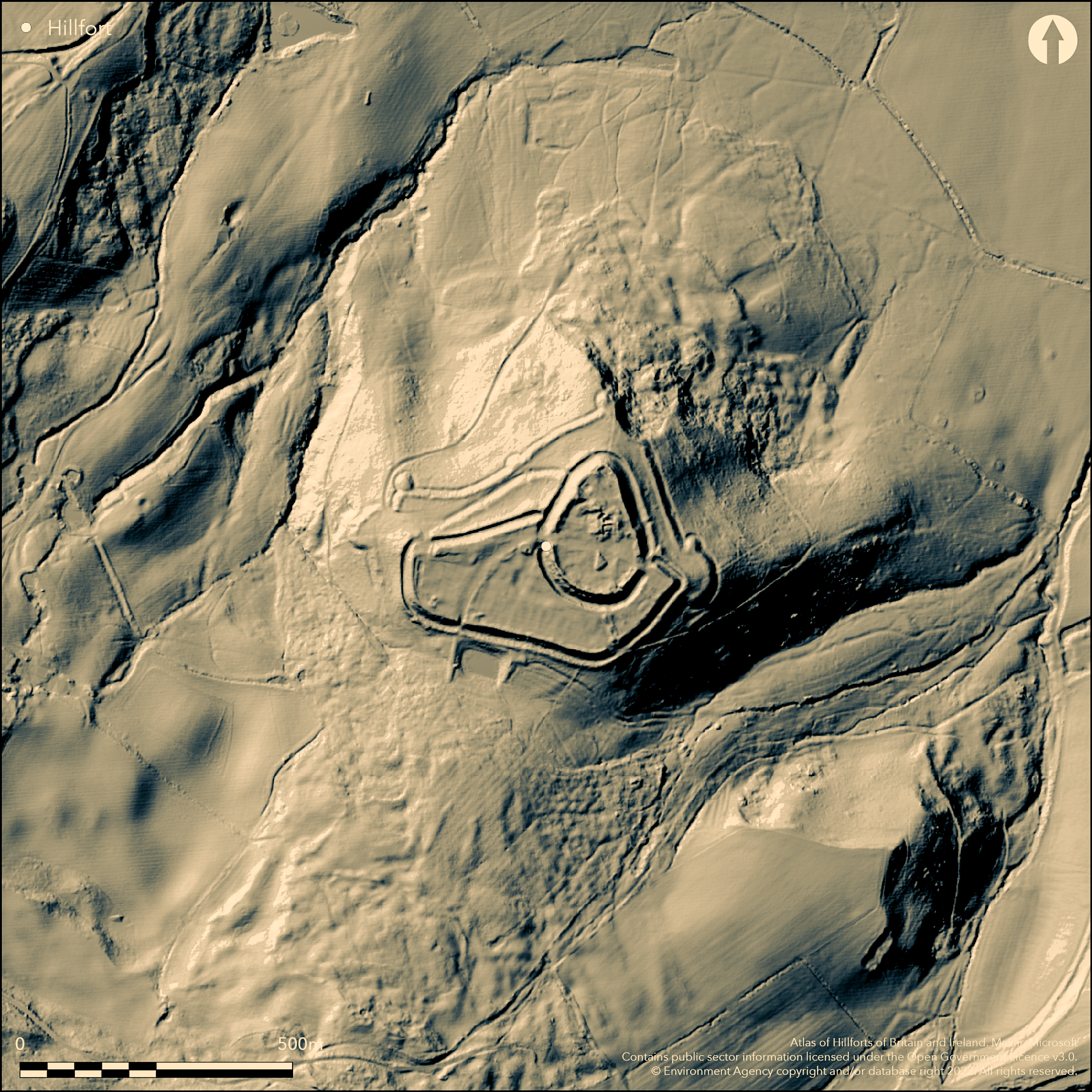
LiDAR 1m DTM Hillshade
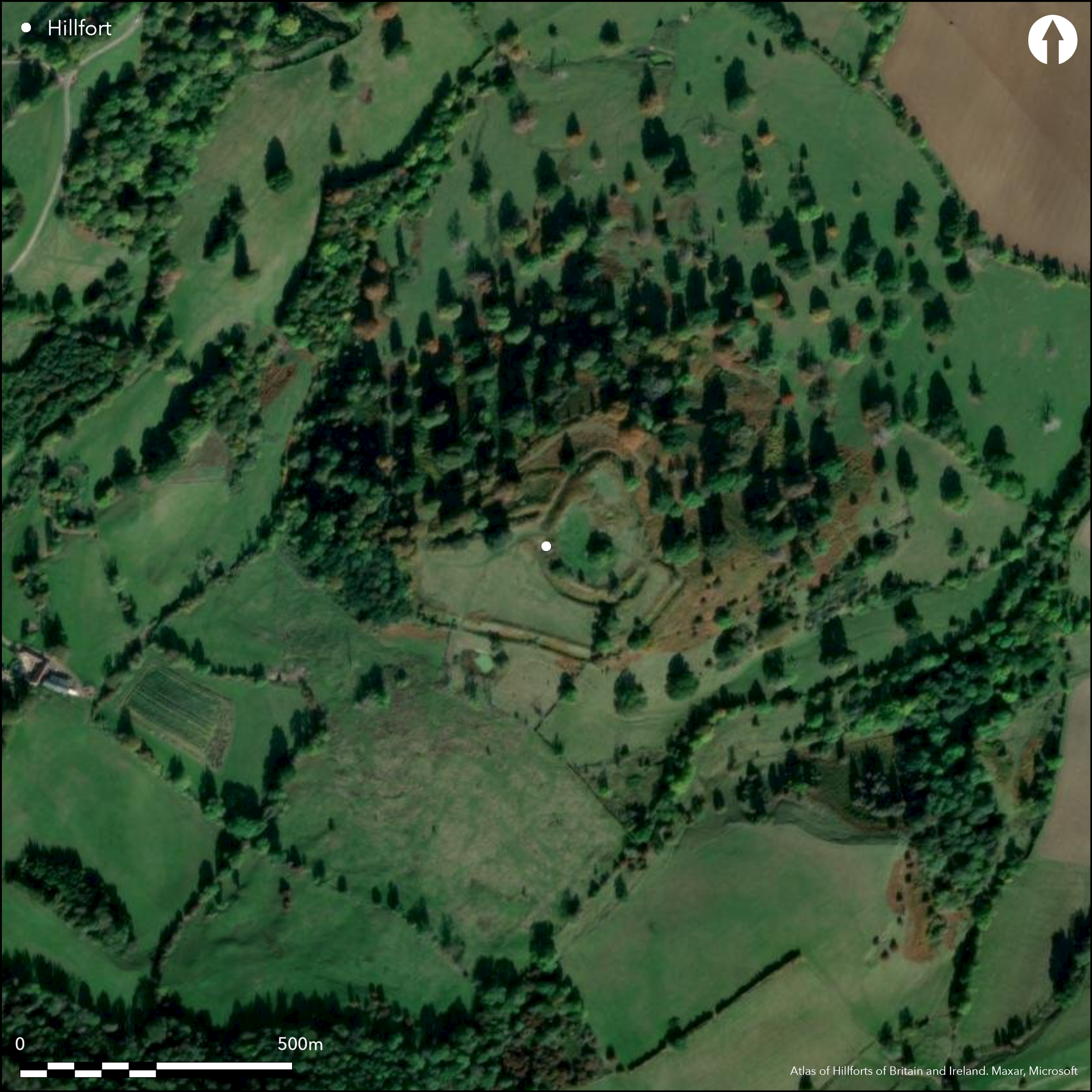
Satellite Imagery
LiDAR 1m DTM Hillshade
Satellite Imagery
Scroll left/right to view further images.
HER: Worcestershire MWR97 (WSM00283)
NMR: SO 94 SE 14 (118105)
SM: 1005279
NGR: SO978402
X: 397889 Y: 240229 (OSGB36)
Two, probably Iron Age, hillforts, or one constructed in two phases, later reused as Norman castle and later medieval castle erected by Robert le Dispenser. On 1st Ed OS map (1885-1900). Site generally follows contours. Until 1396 the seat of Beauchamp family with site a deer park from 1234 and buildings still habitable in the early 16th century. Sited on a prominent spur on the NE slopes of Bredon Hill. The exact form of the prehistoric defences are difficult to disentangle from the later Norman and medieval developments, but earthworks extensive with large inner bailey commanding a N slope with strong ditch and bank and vast outer bailey with well-preserved bank and ditch and further defences to N and E. S rampart may be a Norman re-cutting of original Iron Age feature, whilst outer N rampart was left in its original condition. Small excavation in 1959 by C.C. Dyer and survey by Herefordshire and Worcester Archaeology Service 1995 to determine location, past work, spoil heaps and erosion ahead of reinstatement works. Site mostly former deer park with scattered trees; S part pasture.
Citizen Science: ✓
Reliability of Data: Unconfirmed
Reliability of Interpretation: Unconfirmed
X: -226225 Y: 6811053 (EPSG: 3857)
Longitude: -2.032217728341138 Latitude: 52.06039747011026 (EPSG:4326)
Country: England
Current County or Unitary Authority: Worcestershire
Historic County: Worcestershire
Current Parish/Community/Council/Townland: Elmley Castle
Ramparts possibly upstanding in places.
| Extant | ✓ |
| Cropmark | ✗ |
| Likely Destroyed | ✗ |
Elmley Castle. Mostly former deer park with scattered trees. S part pasture.
| Woodland | ✓ |
| Commercial Forestry Plantation | ✗ |
| Parkland | ✓ |
| Pasture (Grazing) | ✓ |
| Arable | ✗ |
| Scrub/Bracken | ✗ |
| Bare Outcrop | ✗ |
| Heather/Moorland | ✗ |
| Heath | ✗ |
| Built-up | ✗ |
| Coastal Grassland | ✗ |
| Other | ✓ |
Site generally follows the contours and sited on a prominent spur on the NE slopes of Bredon Hill.
| Contour Fort | ✓ |
| Partial Contour Fort | ✗ |
| Promontory Fort | ✗ |
| Hillslope Fort | ✗ |
| Level Terrain Fort | ✗ |
| Marsh Fort | ✗ |
| Multiple Enclosure Fort | ✗ |
| Hilltop | ✗ |
| Coastal Promontory | ✗ |
| Inland Promontory | ✗ |
| Valley Bottom | ✗ |
| Knoll/Hillock/Outcrop | ✗ |
| Ridge | ✗ |
| Cliff/Plateau-edge/Scarp | ✗ |
| Hillslope | ✗ |
| Lowland | ✗ |
| Spur | ✓ |
Dominant Topographic Feature: Prominent spur on Bredon Hill.
| North | ✗ |
| Northeast | ✓ |
| East | ✗ |
| Southeast | ✗ |
| South | ✗ |
| Southwest | ✗ |
| West | ✗ |
| Northwest | ✗ |
| Level | ✗ |
Altitude: 240.0m
N/A
Norman and later developments within earlier Iron Age enclosure.
Reliability: C - Low
| Pre 1200BC | ✗ |
| 1200BC - 800BC | ✗ |
| 800BC - 400BC | ✗ |
| 400BC - AD50 | ✗ |
| AD50 - AD400 | ✗ |
| AD400 - AD 800 | ✗ |
| Post AD800 | ✗ |
| Unknown | ✓ |
| Pre Hillfort: | None |
| Post Hillfort: | Norman and later deer park and developments. |
| Morphology/Earthwork/Typology: | Norman and later developments within earlier Iron Age enclosure. |
On 1st Ed OS map (1885-1900). Small investigation 1959 directed by C.C. Dyer. Survey by Herefordshire and Worcester Archaeology Service in 1995 to determine location, past work, spoil heaps and erosion ahead of reinstatement works.
| Excavation (1959): | Directed by C.C. Dyer. |
| Other (1995): | Directed by M. Napthan, Herefordshire and Worcester County Council. |
| 1st Identified Map Depiction (None): | 1st Ed OS |
Rough excavation of unknown date. Some pottery, its nature not known. Aerial photographs show that S rampart may be a Norman re-cutting of the original earthwork
Probable water supply on site to be determined.
| None | ✗ |
| Spring | ✗ |
| Stream | ✗ |
| Pool | ✗ |
| Flush | ✗ |
| Well | ✗ |
| Other | ✓ |
None
| No Known Features | ✓ |
| Round Stone Structures | ✗ |
| Rectangular Stone Structures | ✗ |
| Curvilinear Platforms | ✗ |
| Other Roundhouse Evidence | ✗ |
| Pits | ✗ |
| Quarry Hollows | ✗ |
| Other | ✗ |
Rough excavation of unknown date.
| No Known Excavation | ✗ |
| Pits | ✗ |
| Postholes | ✗ |
| Roundhouses | ✗ |
| Rectangular Structures | ✗ |
| Roads/Tracks | ✗ |
| Quarry Hollows | ✗ |
| Other | ✓ |
| Nothing Found | ✗ |
None
| No Known Geophysics | ✓ |
| Pits | ✗ |
| Roundhouses | ✗ |
| Rectangular Structures | ✗ |
| Roads/Tracks | ✗ |
| Quarry Hollows | ✗ |
| Other | ✗ |
| Nothing Found | ✗ |
Some pottery, its nature not known, in Birmingham Museum and Art Gallery.
| No Known Finds | ✗ |
| Pottery | ✓ |
| Metal | ✗ |
| Metalworking | ✗ |
| Human Bones | ✗ |
| Animal Bones | ✗ |
| Lithics | ✗ |
| Environmental | ✗ |
| Other | ✗ |
Aerial photographs show that S rampart may be a Norman re-cutting of the original earthwork.
| APs Not Checked | ✗ |
| None | ✗ |
| Roundhouses | ✗ |
| Rectangular Structures | ✗ |
| Pits | ✗ |
| Postholes | ✗ |
| Roads/Tracks | ✗ |
| Other | ✓ |
Entrance not determined.
| 0: | None |
| 2: | None |
Guard Chambers: ✗
Chevaux de Frise: ✗
Earthworks extensive (but not all prehistoric) with large inner bailey commanding a N slope with strong ditch and bank and vast outer bailey with well-preserved bank and ditch and further defences to N and E. S rampart may be a Norman re-cutting of original Iron Age feature, whilst outer N rampart was left in its original condition
| Area 1: | 6.9ha. |
| Total: | 6.9ha. |
Total Footprint Area: Noneha.
None
| ✓ | Two, probably Iron Age, hillforts, or one constructed in two phases, later reused as Norman castle. |
| ✗ | Prehistoric defences cannot be exactly determined because of later features. |
| NE Quadrant: | None |
| SE Quadrant: | None |
| SW Quadrant: | None |
| NW Quadrant: | None |
| Total: | None |
| Partial Univallate | ✗ |
| Univallate | ✗ |
| Partial Bivallate | ✗ |
| Bivallate | ✗ |
| Partial Multivallate | ✗ |
| Multivallate | ✗ |
| Unknown | ✓ |
| Partial Univallate | ✗ |
| Univallate | ✗ |
| Partial Bivallate | ✗ |
| Bivallate | ✗ |
| Partial Multivallate | ✗ |
| Multivallate | ✗ |
None
| None | ✗ |
| Earthen Bank | ✓ |
| Stone Wall | ✗ |
| Rubble | ✗ |
| Wall-walk | ✗ |
| Evidence of Timber | ✗ |
| Vitrification | ✗ |
| Other Burning | ✗ |
| Palisade | ✗ |
| Counter Scarp Bank | ✗ |
| Berm | ✗ |
| Unfinished | ✗ |
| Other | ✗ |
Rough excavation showed free standing buildings and possible small keep to N angle of bailey, but no prehistoric features.
| None | ✓ |
| Earthen Bank | ✗ |
| Stone Wall | ✗ |
| Murus Duplex | ✗ |
| Timber-framed | ✗ |
| Timber-laced | ✗ |
| Vitrification | ✗ |
| Other Burning | ✗ |
| Palisade | ✗ |
| Counter Scarp Bank | ✗ |
| Berm | ✗ |
| Unfinished | ✗ |
| No Known Excavation | ✗ |
| Other | ✗ |
| ✗ | None |
| ✗ | Prehistoric defences have not been exactly determined because of later features. |
Number of Ditches: None
| ✗ | None |
Aston, M. and Bond, C.J. 1970. Elmley Castle, Worcs (SO 980403). West Midlands Archaeological News Sheet. Vol 13, 25 and facing 26.
Dyer,C. 1965, Note on the Pottery and other Objects from Elmley Castle, University of Birmingham Historical Journal. 10, 88-9.
Napthan, M. 1995. Report M/1995/Survey at Elmley Castle, Report No 246, Hereford and Worcester County Council Archaeology Service.
Page, W. and Willis-Bund, J.W. (eds) 1924. Victoria History of the Counties of England: a history of the County of Worcestershire, Vol IV, 431-3, London: St Catherine Press.
Atlas of Hillforts:
Wikidata:
This work is licensed under CC BY-SA 4.0![]()
![]()
![]() and should be cited as:
and should be cited as:
Lock, Gary and Ralston, Ian. 2024. Atlas of Hillforts of Britain and Ireland. Available at: https://hillforts.arch.ox.ac.uk
Document Version 1.1