LiDAR 1m DTM Hillshade
Satellite Imagery
LiDAR 1m DTM Hillshade
Satellite Imagery
Scroll left/right to view further images.
HER: Worcestershire MWR661 (WSM02113)
NMR: SO 84 NW 3 (115937)
SM: None
NGR: SO848491
X: 384829 Y: 249117 (OSGB36)
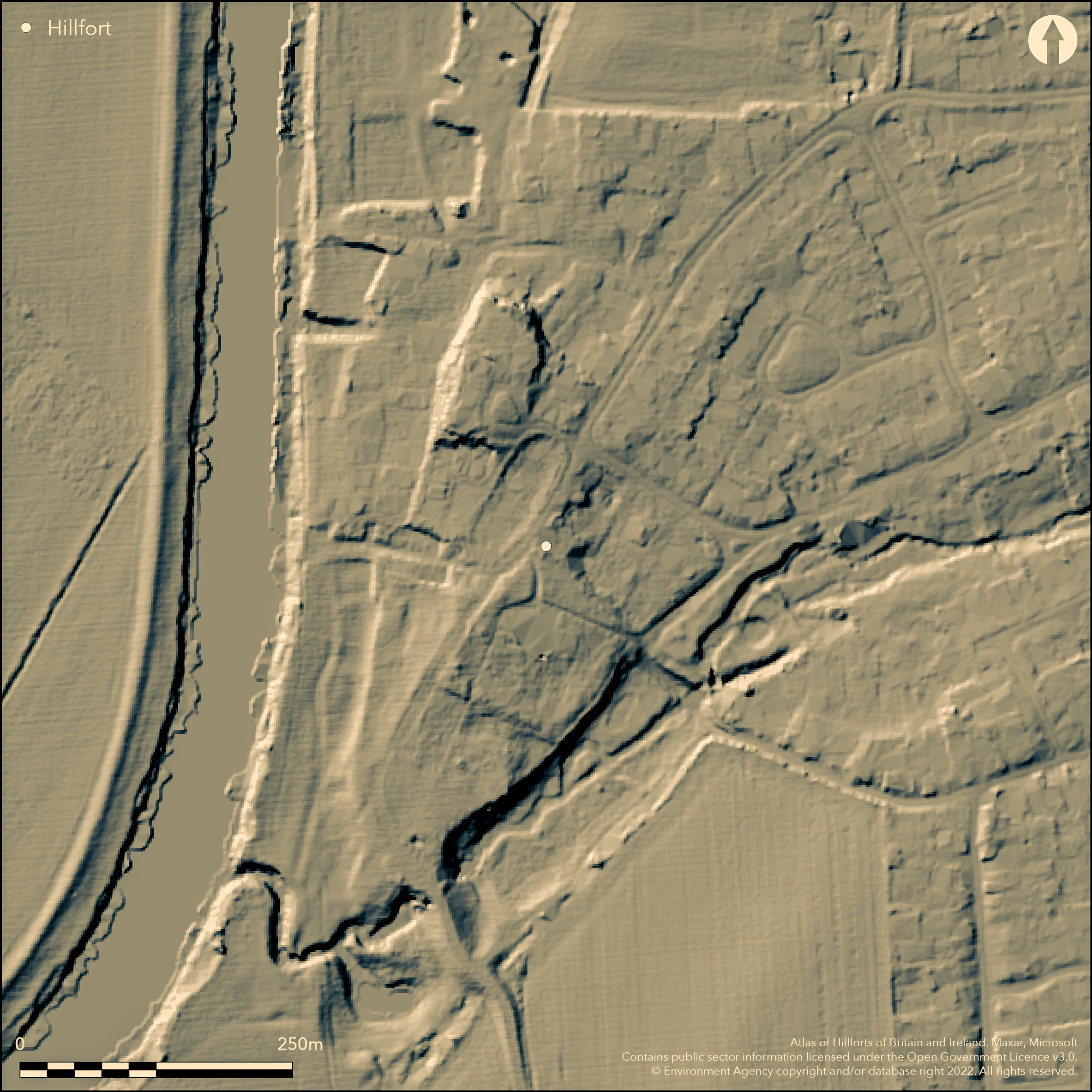
Destroyed inland promontory fort in lowland location on gravel riverine terrace, beween the the E bank of the River Severn and Hatfield Brook, some 2.5m above the flood plain. On NE artificial bank with ditch dug across terrace, the rest of the earthwork being formed by scarping of natural banks of terrace. The earthworks, formerly a Saxon monastery and Bishop's Palace, enclose the church. A slight bank on the S side of the churchyard extends beyond, returning N'wards outside the W boundary of the churchyard. Some excavation by Webster in 1954 and O' Neil in 1956. The latter trenched at the NW corner, could not find the ramparts, but down the lane towards the Severn a clay gully was suggested as a possible ditch. Single sherd of Iron Age pottery found. Rampart, though in good condition to 1836, is now destroyed, finally by housing, and only the scarps of terrace remains, rising from marshy ground.
Citizen Science: ✗
Reliability of Data: Confirmed
Reliability of Interpretation: Confirmed
X: -247475 Y: 6825497 (EPSG: 3857)
Longitude: -2.2231088296978996 Latitude: 52.14010042601525 (EPSG:4326)
Country: England
Current County or Unitary Authority: Worcestershire
Historic County: Worcestershire
Current Parish/Community/Council/Townland: Kempsey
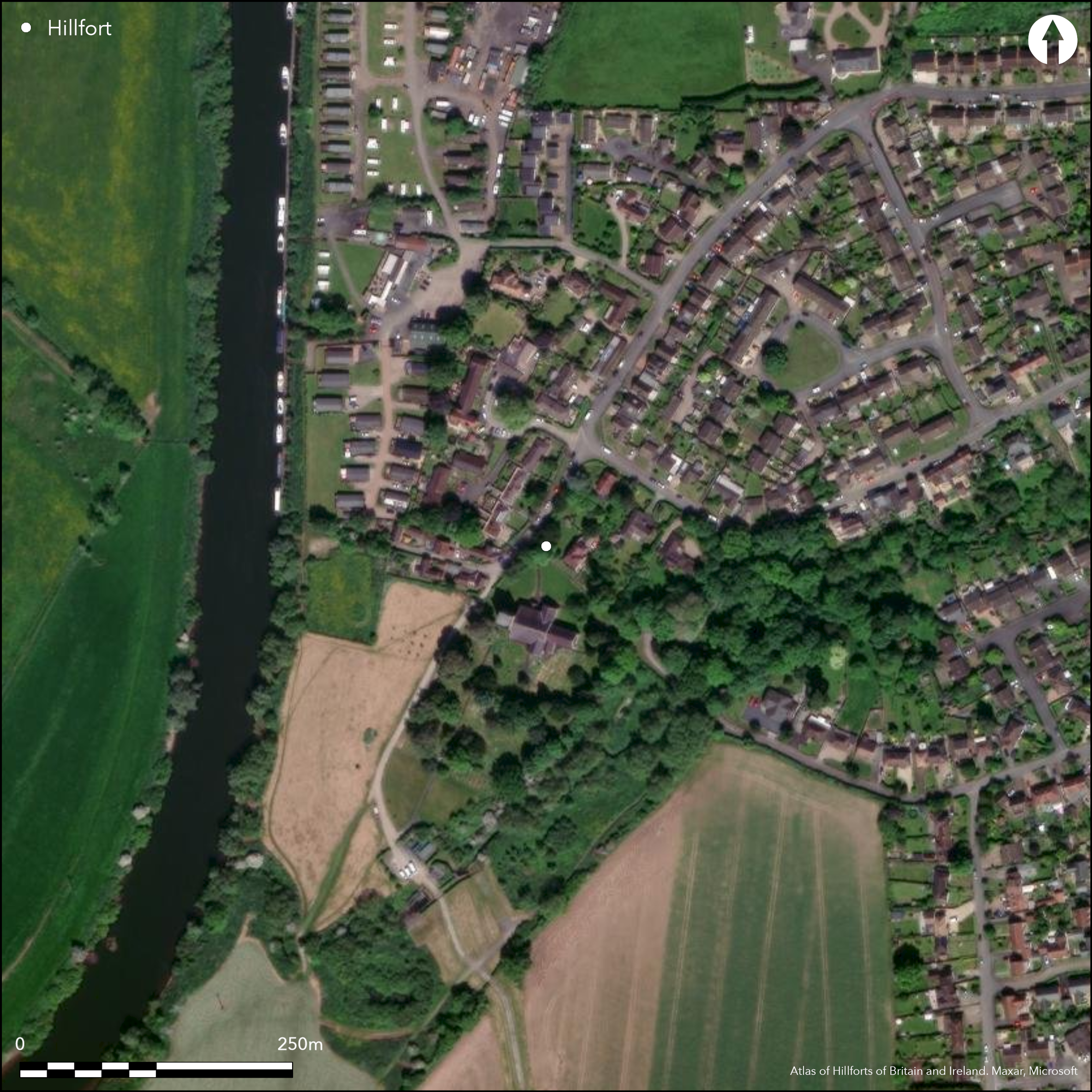
Bank finally destroyed by housing.
| Extant | ✗ |
| Cropmark | ✗ |
| Likely Destroyed | ✓ |
Site of church.
| Woodland | ✗ |
| Commercial Forestry Plantation | ✗ |
| Parkland | ✗ |
| Pasture (Grazing) | ✗ |
| Arable | ✗ |
| Scrub/Bracken | ✗ |
| Bare Outcrop | ✗ |
| Heather/Moorland | ✗ |
| Heath | ✗ |
| Built-up | ✓ |
| Coastal Grassland | ✗ |
| Other | ✗ |
Destroyed promontory fort in lowland location on gravel riverine terrace, beween the the E bank of the River Severn and Hatfield Brook, some 2.5m above the flood plain.
| Contour Fort | ✗ |
| Partial Contour Fort | ✗ |
| Promontory Fort | ✓ |
| Hillslope Fort | ✗ |
| Level Terrain Fort | ✗ |
| Marsh Fort | ✗ |
| Multiple Enclosure Fort | ✗ |
| Hilltop | ✗ |
| Coastal Promontory | ✗ |
| Inland Promontory | ✓ |
| Valley Bottom | ✓ |
| Knoll/Hillock/Outcrop | ✗ |
| Ridge | ✗ |
| Cliff/Plateau-edge/Scarp | ✗ |
| Hillslope | ✗ |
| Lowland | ✓ |
| Spur | ✗ |
Dominant Topographic Feature: Riverine gravel terrace.
| North | ✗ |
| Northeast | ✗ |
| East | ✗ |
| Southeast | ✗ |
| South | ✗ |
| Southwest | ✗ |
| West | ✗ |
| Northwest | ✗ |
| Level | ✓ |
Altitude: 18.0m
N/A
Sherd of Iron Age pottery found nearby in possible ditch.
Reliability: C - Low
| Pre 1200BC | ✗ |
| 1200BC - 800BC | ✗ |
| 800BC - 400BC | ✗ |
| 400BC - AD50 | ✓ |
| AD50 - AD400 | ✗ |
| AD400 - AD 800 | ✗ |
| Post AD800 | ✗ |
| Unknown | ✗ |
| Pre Hillfort: | None |
| Post Hillfort: | None |
| Artefactual: | Sherd of Iron Age pottery from possible ditch. |
Small excavation by G. Webster 1954 and H.E. O.Neil 1956.
| Excavation (1954): | Excavation by G. Webster. |
| Excavation (1956): | Excavation by H.E. O'Neil. |
No details found in excavations. Sherd of Iron Age pottery found in nearby possible ditch.
None
| None | ✓ |
| Spring | ✗ |
| Stream | ✗ |
| Pool | ✗ |
| Flush | ✗ |
| Well | ✗ |
| Other | ✗ |
None
| No Known Features | ✓ |
| Round Stone Structures | ✗ |
| Rectangular Stone Structures | ✗ |
| Curvilinear Platforms | ✗ |
| Other Roundhouse Evidence | ✗ |
| Pits | ✗ |
| Quarry Hollows | ✗ |
| Other | ✗ |
No details found in excavations.
| No Known Excavation | ✗ |
| Pits | ✗ |
| Postholes | ✗ |
| Roundhouses | ✗ |
| Rectangular Structures | ✗ |
| Roads/Tracks | ✗ |
| Quarry Hollows | ✗ |
| Other | ✓ |
| Nothing Found | ✗ |
None
| No Known Geophysics | ✓ |
| Pits | ✗ |
| Roundhouses | ✗ |
| Rectangular Structures | ✗ |
| Roads/Tracks | ✗ |
| Quarry Hollows | ✗ |
| Other | ✗ |
| Nothing Found | ✗ |
Sherd of Iron Age pottery found in nearby possible ditch.
| No Known Finds | ✗ |
| Pottery | ✓ |
| Metal | ✗ |
| Metalworking | ✗ |
| Human Bones | ✗ |
| Animal Bones | ✗ |
| Lithics | ✗ |
| Environmental | ✗ |
| Other | ✗ |
None
| APs Not Checked | ✓ |
| None | ✗ |
| Roundhouses | ✗ |
| Rectangular Structures | ✗ |
| Pits | ✗ |
| Postholes | ✗ |
| Roads/Tracks | ✗ |
| Other | ✗ |
No entrance recorded.
| 0: | None |
| 2: | None |
Guard Chambers: ✗
Chevaux de Frise: ✗
On NE artificial bank with ditch dug across terrace, the rest of the earthwork being formed by scarping of natural banks of terrace.
| Area 1: | 4.45ha. |
| Total: | 4.45ha. |
Total Footprint Area: Noneha.
None
| ✗ | None |
| ✗ | Rampart across neck of promontory. |
| NE Quadrant: | 1 |
| SE Quadrant: | 0 |
| SW Quadrant: | 0 |
| NW Quadrant: | 0 |
| Total: | 1 |
| Partial Univallate | ✓ |
| Univallate | ✗ |
| Partial Bivallate | ✗ |
| Bivallate | ✗ |
| Partial Multivallate | ✗ |
| Multivallate | ✗ |
| Unknown | ✗ |
| Partial Univallate | ✗ |
| Univallate | ✗ |
| Partial Bivallate | ✗ |
| Bivallate | ✗ |
| Partial Multivallate | ✗ |
| Multivallate | ✗ |
None
| None | ✓ |
| Earthen Bank | ✗ |
| Stone Wall | ✗ |
| Rubble | ✗ |
| Wall-walk | ✗ |
| Evidence of Timber | ✗ |
| Vitrification | ✗ |
| Other Burning | ✗ |
| Palisade | ✗ |
| Counter Scarp Bank | ✗ |
| Berm | ✗ |
| Unfinished | ✗ |
| Other | ✗ |
O' Neil did not find rampart in excavation.
| None | ✓ |
| Earthen Bank | ✗ |
| Stone Wall | ✗ |
| Murus Duplex | ✗ |
| Timber-framed | ✗ |
| Timber-laced | ✗ |
| Vitrification | ✗ |
| Other Burning | ✗ |
| Palisade | ✗ |
| Counter Scarp Bank | ✗ |
| Berm | ✗ |
| Unfinished | ✗ |
| No Known Excavation | ✗ |
| Other | ✗ |
| ✗ | None |
| ✓ | Ditch to bank across promontory, now a buried feature. |
Number of Ditches: 1
| ✗ | None |
O' Neil, H.E. 1956. Court house excavations: Kempsey, January 1956, Trans Worcs Arch Soc, 33, 33-44.
Page, W. and Willis-Bund, J.W. (eds) 1924. Victoria History of the Counties of England: a history of the County of Worcestershire, Vol IV, 421, London: St Catherine Press.
Webster, G. 1955. A trial excavation at Kempsey, Trans Worcs Arch Soc, 32, 13-14.
Atlas of Hillforts:
Wikidata:
This work is licensed under CC BY-SA 4.0![]()
![]()
![]() and should be cited as:
and should be cited as:
Lock, Gary and Ralston, Ian. 2024. Atlas of Hillforts of Britain and Ireland. Available at: https://hillforts.arch.ox.ac.uk
Document Version 1.1