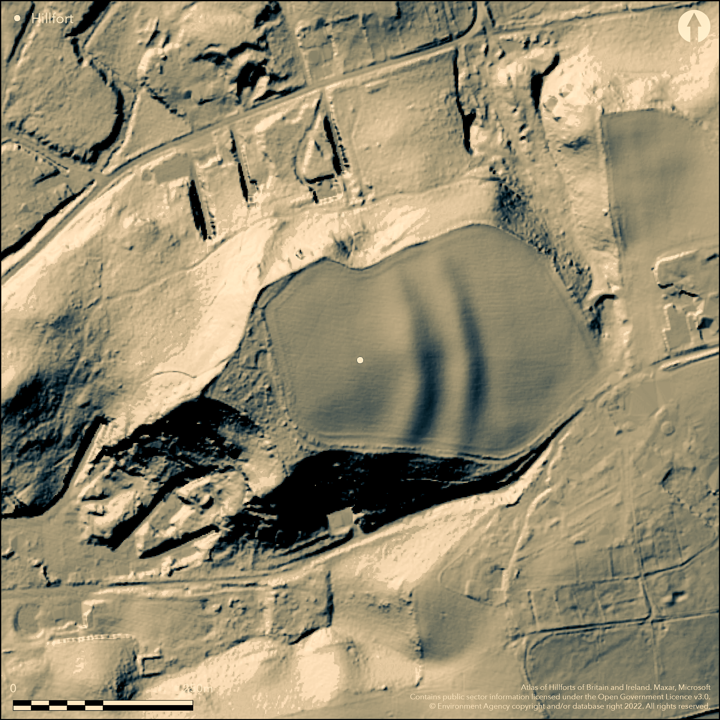
LiDAR 1m DTM Hillshade
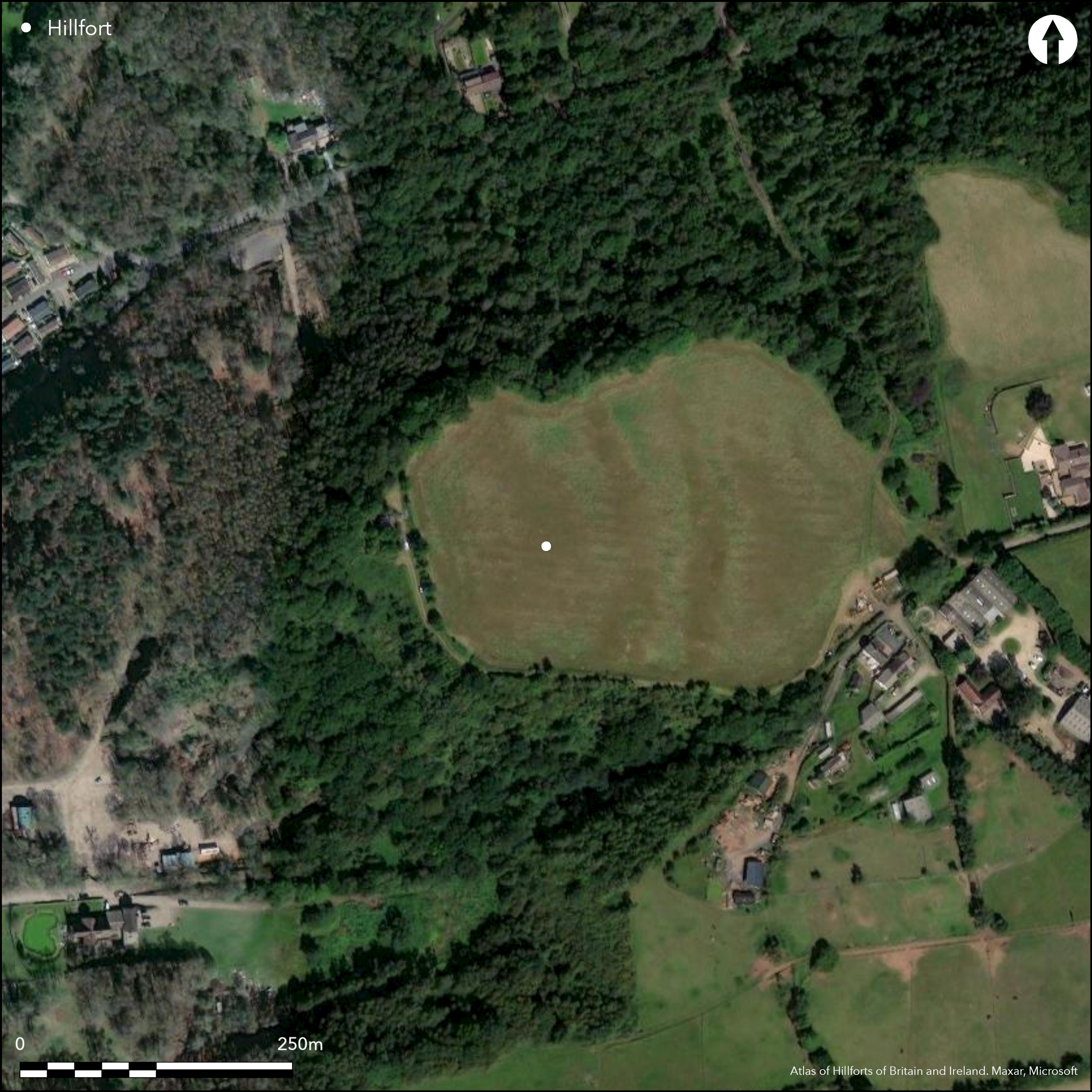
Satellite Imagery
LiDAR 1m DTM Hillshade
Satellite Imagery
Scroll left/right to view further images.
HER: Worcestershire MWR2561 (WSM08203)
NMR: SO 88 SW 13 (116769)
SM: 1010721
NGR: SO 8219 8088
X: 382198 Y: 280882 (OSGB36)
Remains of a small, multivallate, inland promontory fort sited on steep sided spur on Drakelow Hill at S end of Kinver Edge. Site measures c. 230m by 160m, with overall footprint c. 3.6ha and internal area c. 2ha. Two or three substantial cross banks and ditches curve NW to SE across spur terminating at steep slopes, thus three sides rely on steepness of natural slopes. Deep-cut holloway around S side of hill from below to give access to possible entrance which is not obviously defined. Lower half of possibly pre-Roman rotary quern found. Cultivated and ploughed down.
Citizen Science: ✗
Reliability of Data: Confirmed
Reliability of Interpretation: Confirmed
X: -251943 Y: 6877448 (EPSG: 3857)
Longitude: -2.263239652864302 Latitude: 52.42559996010973 (EPSG:4326)
Country: England
Current County or Unitary Authority: Worcestershire
Historic County: Worcestershire
Current Parish/Community/Council/Townland: Wolverley and Cookley
Ploughed down remains only.
| Extant | ✓ |
| Cropmark | ✗ |
| Likely Destroyed | ✗ |
Formerly part occupied by radar station.
| Woodland | ✗ |
| Commercial Forestry Plantation | ✗ |
| Parkland | ✗ |
| Pasture (Grazing) | ✗ |
| Arable | ✓ |
| Scrub/Bracken | ✗ |
| Bare Outcrop | ✗ |
| Heather/Moorland | ✗ |
| Heath | ✗ |
| Built-up | ✓ |
| Coastal Grassland | ✗ |
| Other | ✗ |
Multivallate promontory hillfort sited on steep sided spur of Drakelow Hill at S end of Kinver Edge and above the River Stour to the SE.
| Contour Fort | ✗ |
| Partial Contour Fort | ✗ |
| Promontory Fort | ✓ |
| Hillslope Fort | ✗ |
| Level Terrain Fort | ✗ |
| Marsh Fort | ✗ |
| Multiple Enclosure Fort | ✗ |
| Hilltop | ✗ |
| Coastal Promontory | ✗ |
| Inland Promontory | ✓ |
| Valley Bottom | ✗ |
| Knoll/Hillock/Outcrop | ✗ |
| Ridge | ✗ |
| Cliff/Plateau-edge/Scarp | ✗ |
| Hillslope | ✗ |
| Lowland | ✗ |
| Spur | ✓ |
Dominant Topographic Feature: Drakelow Hill.
| North | ✗ |
| Northeast | ✗ |
| East | ✗ |
| Southeast | ✗ |
| South | ✗ |
| Southwest | ✗ |
| West | ✗ |
| Northwest | ✗ |
| Level | ✓ |
Altitude: 100.0m
N/A
None
Reliability: D - None
| Pre 1200BC | ✗ |
| 1200BC - 800BC | ✗ |
| 800BC - 400BC | ✗ |
| 400BC - AD50 | ✗ |
| AD50 - AD400 | ✗ |
| AD400 - AD 800 | ✗ |
| Post AD800 | ✗ |
| Unknown | ✓ |
| Pre Hillfort: | None |
| Post Hillfort: | None |
Survey by Wolverley and Cookley Archaeological Society, date unknown. Watching Brief, Worcestershire CC Archeological Service 2000 (Miller and Jones 2001).
| Other (2000): | Watching Brief, Worcestershire CC Archeological Service. |
| Other (None): | Wolverley and Cookley Archaeological Society, date unknown. |
No internal features visible. Lower half of possibly pre-Roman of Hunsbury type brown sandstone rotary quern, c. 42cms in diameter, found. Now in Worcester County Museum.
None defined.
| None | ✓ |
| Spring | ✗ |
| Stream | ✗ |
| Pool | ✗ |
| Flush | ✗ |
| Well | ✗ |
| Other | ✗ |
None
| No Known Features | ✓ |
| Round Stone Structures | ✗ |
| Rectangular Stone Structures | ✗ |
| Curvilinear Platforms | ✗ |
| Other Roundhouse Evidence | ✗ |
| Pits | ✗ |
| Quarry Hollows | ✗ |
| Other | ✗ |
None
| No Known Excavation | ✓ |
| Pits | ✗ |
| Postholes | ✗ |
| Roundhouses | ✗ |
| Rectangular Structures | ✗ |
| Roads/Tracks | ✗ |
| Quarry Hollows | ✗ |
| Other | ✗ |
| Nothing Found | ✗ |
None
| No Known Geophysics | ✓ |
| Pits | ✗ |
| Roundhouses | ✗ |
| Rectangular Structures | ✗ |
| Roads/Tracks | ✗ |
| Quarry Hollows | ✗ |
| Other | ✗ |
| Nothing Found | ✗ |
Lower half of possibly pre-Roman of Hunsbury type brown sandstone rotary quern, c. 42cms in diameter, found. Now in Worcester County Museum.
| No Known Finds | ✓ |
| Pottery | ✗ |
| Metal | ✗ |
| Metalworking | ✗ |
| Human Bones | ✗ |
| Animal Bones | ✗ |
| Lithics | ✗ |
| Environmental | ✗ |
| Other | ✗ |
None
| APs Not Checked | ✓ |
| None | ✗ |
| Roundhouses | ✗ |
| Rectangular Structures | ✗ |
| Pits | ✗ |
| Postholes | ✗ |
| Roads/Tracks | ✗ |
| Other | ✗ |
Deep-cut hollow-way around S side of hill from below to give access to possible entrance which is not obviously defined.
| None: | Total not defined. |
| 2: | Possible entrance not indicated by break in rampart, but position of hollow way. |
Guard Chambers: ✗
Chevaux de Frise: ✗
| 1. Hollow Way (South): | Possible site only. |
Two substantial cross banks and ditches curve NW to SE across spur terminating at steep slopes, thus three sides rely on the steepness of the natural slopes. Sites measures 230m x 160m. Stone and earth rampart, two ditches.
| Area 1: | 2.0ha. |
| Total: | 2.0ha. |
Total Footprint Area: 3.6ha.
None
| ✗ | None |
| ✗ | None |
| NE Quadrant: | 0 |
| SE Quadrant: | 3 |
| SW Quadrant: | 0 |
| NW Quadrant: | 3 |
| Total: | 3 |
| Partial Univallate | ✗ |
| Univallate | ✗ |
| Partial Bivallate | ✗ |
| Bivallate | ✗ |
| Partial Multivallate | ✓ |
| Multivallate | ✗ |
| Unknown | ✗ |
| Partial Univallate | ✗ |
| Univallate | ✗ |
| Partial Bivallate | ✗ |
| Bivallate | ✗ |
| Partial Multivallate | ✗ |
| Multivallate | ✗ |
Stone from outside of the area ploughed out of the earthen banks.
| None | ✗ |
| Earthen Bank | ✓ |
| Stone Wall | ✓ |
| Rubble | ✗ |
| Wall-walk | ✗ |
| Evidence of Timber | ✗ |
| Vitrification | ✗ |
| Other Burning | ✗ |
| Palisade | ✗ |
| Counter Scarp Bank | ✗ |
| Berm | ✗ |
| Unfinished | ✗ |
| Other | ✗ |
None
| None | ✗ |
| Earthen Bank | ✗ |
| Stone Wall | ✗ |
| Murus Duplex | ✗ |
| Timber-framed | ✗ |
| Timber-laced | ✗ |
| Vitrification | ✗ |
| Other Burning | ✗ |
| Palisade | ✗ |
| Counter Scarp Bank | ✗ |
| Berm | ✗ |
| Unfinished | ✗ |
| No Known Excavation | ✓ |
| Other | ✗ |
| ✗ | None |
| ✓ | Possibly two ditches as buried features. |
Number of Ditches: 2
| ✗ | None |
Miller D. and Jones L. 2001. Archaeological watching brief at Drakelow Hillfort, Wolverley and Cookley, Worcestershire/Report No 893. Worcester: Worcestershire County Council, Archaeological Service.
Pagett, T. 1994. Review of a number of Iron Age forts in Worcestershire. Monograph.
Atlas of Hillforts:
Wikidata:
This work is licensed under CC BY-SA 4.0![]()
![]()
![]() and should be cited as:
and should be cited as:
Lock, Gary and Ralston, Ian. 2024. Atlas of Hillforts of Britain and Ireland. Available at: https://hillforts.arch.ox.ac.uk
Document Version 1.1